On November 17, OPB’s Oregon Field Guide aired a special 1-hour look at the Columbia River Gorge Scenic Act, commemorating the 25th anniversary of the legislation.
The show provides a comprehensive look at the history of the Gorge Act, its friends and foes and some of the future challenges, including those never anticipated when the legislation was written — such as the recent land rush for wind turbine sites. Several of the most prominent early defenders of the Gorge are included, including Chuck Williams and Nancy Russell.
The program also includes in-depth look at the Native American legacy in the Gorge, and the ironic effect of the Gorge Act bringing a surge of new residents since it was signed into law — all seeking a life amid the scenery, and bringing demand for hundreds of new homes and new industry to a new level in the Gorge.
The program overlooks the massive increase in recreation demand over the past three decades, and the lack of trails to serve the crowds. Not much attention is paid to the future role of federal stewardship in the Gorge, and especially the national park vision that Chuck Williams advocated during the fight for protection.
Tsagaglalal or She Who Watches (USFS)
Likewise, Senator Bob Packwood is given too much credit for passage of the Gorge Act (in his own words, of course, in typical Bob Packwood form), while Senator Mark Hatfield is not given enough. Had Hatfield been alive to comment, he would undoubtedly have given a humble account of his key role in developing the legislation. This political history might make for a future documentary on the evolution of the Gorge Act, itself, perhaps based on Carl Abbot’s book Planning a New West: The Columbia River Gorge National Scenic Area.
Still, the program provides a very good overview of the Gorge Act over the past quarter century, and how much it has already changed the public/private balance of interests in the Gorge. Here is the documentary in full (approximately 55 minutes):
The WyEast Blog has a new, shorter URL as of today — www.wyeastblog.org — with the goal of making it easier to find, and to underscore the non-profit mission of the Mount Hood National Park Campaign. The old URL will continue to work indefinitely, but the new address will make it a little easier to find the blog, or share the address with others.
Hike along any low-elevation stream in the Cascades and you’re likely to pass colonies of Tolmiea menziesii — more commonly known as the piggyback plant. These humble plants draw their common name from a unique habit of sprouting new plants on top of their leaves (reflected in other common names for the species, including “youth-on-age” and “thousand mothers”).
The botanical name for this species memorializes two giants in the early days of Pacific Northwest botanical discovery: Scottish-Canadian botanist William Fraser Tolmie and Archibald Menzies, the Scottish naturalist for the Vancouver Expedition.
Young leaves on a piggyback plant
These fuzzy little plants thrive in the moist shade of streamside broadleaf trees like red alder and bigleaf maple. As forest floor dwellers, piggyback plants have become expert at reproducing. They can spread along their well-developed rhizomes, through seeds, and of course, through the tiny plantlets that form on their leaves.
A close look at the piggyback plant reveals a whorl of basal leaves, typical of the many species in the saxifrage family. The leaves have 5-7 lobes, and are finely toothed. Both leaves and stems are covered in fine white hairs that give them a soft texture to the touch.
Daughter plantlet on a piggyback plant mother leaf
Piggyback plants produce leaves continually from their base, with larger, older leaves eventually sprouting a “daughter” plantlet. The genius of this reproductive strategy is how it fits into the life cycle of the deciduous forests where the plants thrive. As the older leaves mature, they extend away from the mother plant on 4-6” stems, allowing daughter plantlets that form to touch down well away from the parent plant.
This is where the over-story of deciduous trees come in. Daughter plantlets form mostly over the course of the spring and summer growing season, By autumn, they are ready for falling maple and alder leaves to bury them, pressing tiny rootlets on the daughter plants into contact with the ground, where they can grow and anchor the new plant.
Underside of a mother leaf showing rootlets on a piggyback “daughter”
By the next spring, the new plant is ready to grow on its own, still fed by the nutrients from the fading mother leaf, and still with the connecting stem from the mother leaf forming an umbilical cord to the mother plant. Over time, the mother leaf and stem connecting to the daughter plant wither and die, and the daughter becomes truly independent from the parent.
In spring, piggyback plants produce clusters of tiny, graceful blossoms on 6-10” spikes. Each blossom is capable of producing a small seed capsule filled with tiny seeds. Flower stalks die back over the course of a summer, releasing seeds to grow side-by-side with the cloned plants that have sprouted from rhizomes and “piggyback” plantlets.
Piggyback plant flower (Wikimedia)
As a survival strategy, the seed offspring have the advantage of being cross-pollinated. Over time, seed-based offspring can evolve with the genes of two parents to have new survival characteristics that single parent cloned plants from root or leaf starts inherently lack.
Piggyback Plants in the Commercial Trade
Only a few native plants from Pacific Northwest forests have been hybridized to become commercial cultivars, and still fewer are suitable as indoor plants. The piggyback plant fills this rare niche, somehow adapting to the relatively hot, arid conditions indoors. They are typically sold as hanging basket plants.
Piggyback plant cultivar “Taff’s Gold”
The curious “piggyback” habit is the main attraction for growing the plants indoors. Breeders have created commercial hybrids with larger leaves, more “piggyback” plantlets and even a few variegated cultivars, such as the “Taffs Gold” Tolmiea shown above.
Starting Your Own Piggyback Plant
There’s no need to buy a piggyback plant, kids (and parents) can enjoy collecting and growing piggyback plants collected in the wild. You can make this a two-part adventure for kids by combining the collecting with a day hike, then propagating what you’ve collected at home.
Piggyback plants are plentiful along several family-friendly trails in the Columbia River Gorge: notable among these are the short trails to Latourell Falls, Bridal Veil Falls, Elowah Falls and Wahclella Falls.
On each trail, you’ll find piggyback plants in streamside areas and where deciduous trees grow. Your kids will quickly learn to spot them, and it’s okay to collect a few plantlets for growing at home, as you will be leaving the mother plant behind to produce more (an important lesson for kids).
Materials for starting your own plant
To grow your daughter plant, you’ll need the following:
• small pot (3-4 inches)
• soil-less potting mix
• bobby pin (or paper clip)
• rubber band
• plastic sandwich or freezer bag
Planting your starts is simple: (1) fill the pot to within 1” of the top with soil; (2) place the mother leaf and plantlet in the pot, with rootlets touching the soil; pin in place by pushing the bobby pin (or paper clip) over the mother leaf stem just below the plantlet, and holding it against the soil. Next, (3) sprinkle another 1/4” of potting mix, slightly covering the stem and base of the plantlet, and water well. Finally, (4) secure the plastic bag over the pot with the rubber band to provide a humid environment for the young plantlet to become established.
Piggyback start potted and ready to grow
Keep your new piggyback plant in a bright north or east-facing window, and covered with the plastic bag until you see the plantlet growing. At this point, you can remove the bag and watch your new houseplant grow — or plant it in your yard, where it will thrive in moist shade.
This is a terrific way to get young kids excited about the outdoors, and perhaps develop a green thumb in the process! You can start a piggyback plant at any time, as the plantlets can be collected year-round on the low-elevation Gorge trails listed above.
Each year at about this time I assemble the Mount Hood National Park Scenic Calendar. The proceeds are modest, but do help support the Mount Hood National Park Campaign website and related project expenses. The main purpose is simply to promote the project, and make the case for the campaign with pictures.
I’ve published the calendars since 2004, and the photos in each calendar are from trips and trails I’ve explored in the previous year. Thus, the 2012 calendar features photos I’ve taken on my weekly outings throughout 2011.
I get a surprising number of questions about the photos, so in addition to simply announcing the 2012 calendar, I thought I would dedicate this article to the story behind the images.
The 2012 Scenes
The cover image for the 2012 calendar is a world-class favorite: Punchbowl Falls on Eagle Creek (below), one of our iconic local scenes that is recognized around the world. The Eagle Creek trail is busy year-round, so I picked a Wednesday morning in June to slip in between the crowds, and had Punchbowl Falls to myself for nearly an hour.
Cover: Punchbowl Falls on Eagle Creek
In spring, this view requires wet feet — or waders — to shoot, as I was standing in about a foot of water and 30 feet from the stream bank to capture this image. I chose wet feet over waders, and to say they were numb afterward would be an understatement!
For the January calendar image, I picked this view (below) of the southeast face of Mount Hood, as seen from the slopes of Gunsight Butte. This was taken on a very cold afternoon last January on a snowshoe trip in the Pocket Creek area. This image benefited from some Photoshop editing, as I removed my own boot prints from the otherwise pristine snow in the foreground!
January: Mount Hood from near Pocket Creek
I try to reflect the seasons with the monthly photos as best I can, but the February image (below) of the Sandy Headwall in the new calendar is an example where the scene could be in mid-winter, but was really captured just a few days ago, with the first blanket of snow transforming the summit of Mount Hood.
February: The Sandy Headwall in early autumn
This close-up photo was taken from the slopes of Bald Mountain, near Lolo Pass on a brilliant autumn afternoon. It features a new camera toy I picked up this year, too — a 70-300mm telephoto lens that replaced my older, less powerful version.
For March, the calendar image (below) is from a June hike along the Hot Springs Fork of the Collawash River. The stream is known to many (incorrectly) as “Bagby Creek”, as it is home to the historic guard station and rustic bath houses at Bagby Hot Springs.
March: The Hot Springs Fork of the Collowash River
The Bagby area has been in the news this year because of an ill-conceived and controversial Forest Service plan to privatize the operations, but I hiked the trail for the beauty of the stream, itself. It’s a beautiful forest hike through old-growth forests and past lovely stream views, albeit very well traveled by the hordes of hot-spring seekers!
The April calendar scene (below) is one that few will ever see in person, as it features an off-trail view across little-known Brooks Meadow, on the high slopes of Lookout Mountain, east of Mount Hood. The day was especially memorable for the wildlife all around me as I shot the scene — elk bugling in the forest margins, hummingbirds moving through the acres of wildflowers and several hawks prowling the meadow from the big trees that surround it.
April: Brooks Meadow and Mount Hood
I featured Brooks Meadow in this article earlier this year, and was later disappointed to see closure signs posted at the public access points. So, until the policy changes, this view is officially off-limits to the public.
For the month of May, I picked a much-photographed view of Metlako Falls from along the Eagle Creek Trail (below). This view was captured on the same day as the Punchbowl Falls scene on the calendar cover.
May: Metlako Falls on Eagle Creek
A little secret among photographers is that a clean shot of Metlako Falls requires you to plant at least one foot on the scary side of the cable fence that otherwise keeps hikers from slipping over a 200 foot cliff. It’s perfectly safe… as long as you don’t fall! My main goal was to capture the scene with the spring flowers that appear in the lower left, something I’d admired in other photos.
2011 was a wet year with a persistent snowpack in the Oregon high country, so June hiking was still focused on the lowlands, and especially on waterfalls, which benefited from the runoff. In early June, I made a trip along the Clackamas River Trail to beautiful Pup Creek Falls (below), an impressive, lesser-known cascade tucked into a hidden side canyon, just off the main stem of the Clackamas. I profiled the hike in this WyEast Blog article.
June: Pup Creek Falls
For July, the scene is another familiar view — the sweeping panorama of Crown Point and the Columbia Gorge from Chanticleer Point, at Women’s Forum State Park (below).
In a typical year, this might have been a day for hiking in the mountains, but in 2011, the lingering snowpack persisted until the end of July. This image shows the resulting swollen, flooded Columbia, with spring levels of runoff continuing well into the summer.
July: Crown Point and the Columbia from Chanticleer Point
The high country trails finally opened in early August, and I followed one of my summer rituals with a hike to Cooper Spur, high above Cloud Cap Inn on the east slopes of Mount Hood. This view (below) is from the south Eliot Glacier moraine, just below the spur. I profiled a proposal for improving the Cooper Spur trail in this WyEast Blog article.
Not visible at this scale are the ice climbers who were exploring the lower Eliot Glacier icefall that day, in the right center of the photo.
August: Eliot Glacier and Mount Hood from the slopes of Cooper Spur
In September I was doing research on historic Silcox Hut, located about a mile and a thousand vertical feet above Timberline Lodge. The venerable structure was built in 1939 by the Works Progress Administration for a mere $80,000, and served for many years as the upper terminal of the original Magic Mile chairlift. The Friends of Silcox Hut restored the structure in the 1980s, and it was reopened for overnight guests in 1994.
Though I rarely include man-made structures in the calendar, this view of Silcox Hut (below) shows how the structure seems to rise up as part of the mountain, itself, in a triumph in architectural design. The worker on the ladder is part of a 2011 American Recovery and Reinvestment Act (ARRA) project to further restore the building for generations to come.
September: Historic Silcox Hut
In October, I usually scramble to capture early fall foliage images for the calendar. Mount Hood and a group of vine maples obliged this year in this view from Lolo Pass Road (below), captured just a few days ago on a beautiful Indian Summer day.
October: Mount Hood in Autumn from Lolo Pass Road
The November calendar scene (below) is from Lolo Pass, proper, taken in late October on a crisp evening just before sunset. The scene includes all of the ingredients that make autumn on Mount Hood so rewarding for photographers: the first blanket of snow had fallen at the highest elevations, while the meadows above timberline have turned to shades of read and gold. The mountain, itself, is wrapped in swirling autumn clouds. Spectacular!
November: Mount Hood at sunset from Lolo Pass
The final image in the new calendar is of Tamanawas Falls in winter (below). The falls are located on Cold Spring Creek, a major tributary to the East Fork Hood River, and this scene was captured last January while on a hike with an old friend visiting from Nevada. In this scene, rays of intermittent sunshine were lightening up mist from the falls, creating what can only be described as a “winter wonderland”! The hike to Tamanawas Falls is described in this 2008 WyEast Blog article.
December: Tamanawas Falls on Cold Spring Creek in winter
The thirteen images I chose for the 2012 Mount Hood National Park Calendar were narrowed from 117 images that I had set aside over the course of 2011. These were the “best” of several thousand images taken on something upward of 50 outings to Mount Hood and the Gorge. As always, these adventures took me to new places and discoveries, as well as my old haunts.
And as always, the magnificent scenery further confirmed my conviction that Mount Hood should be set aside as our next National Park! Hopefully, the calendar makes that case, as well.
Where can I get one?
The 2012 calendars are available now at the Mount Hood National Park Campaign store. They are large and functional, measuring 17” across by 22” tall, with plenty of room for writing notes and scheduling activities. They sell for $24.99, with about 25% of the proceeds going to support the Mount Hood National Park Campaign.
The first hiking trails on Mount Hood were built in the late 1890s, radiating from the newly constructed Cloud Cap Inn on the mountain’s north side. The steep hike up the south Eliot Glacier moraine to Cooper Spur was perhaps the first trail, as it was part of the still-popular Cooper Spur route to the summit. The original climber’s trail is still used, though a much gentler route built in the 1960s now ascends the spur in a series of well-graded switchbacks.
The new, graded trail carries thousands of hikers to the top of Cooper Spur each summer. It is among the most spectacular alpine hikes in the country, with jaw-dropping views of the sheer north face of Mount Hood and a close-up look at the massive jumble of flowing ice that makes up the Eliot Glacier.
The snowfields in question on Cooper Spur are permanent enough to be mapped.
It’s hard to know exactly why the newer, graded trail was routed over a set of mostly permanent snowfields when it was built, but this design flaw continues to be a problem for this otherwise exceptional trail. The newer trail initially follows the climber’s route fairly closely, sticking to the rim of the Eliot Glacier where the snow melts early and reliably each summer.
But near the crest of Cooper Spur, the newer route suddenly crosses the face of the spur, traversing to the south shoulder and overlooking the Newton Clark Glacier. It is in this section where the route crosses a set of persistent snowfields that are nearly permanent in all but the driest years.
The snowfields clearly show up in this 1890s view of Mount Hood in late summer.
This flaw in the newer route is confusing and potentially dangerous to the many hikers who venture to the top of the spur each summer. At 8,514 feet, the summit of Cooper Spur is truly alpine, so one of the benefits of the modern trail is to provide a relatively manageable hike to the top of the spur for the average visitor, despite the high elevation.
But when the trail disappears into the snow in this final pitch, hikers often resort to climbing directly up the snowfield — a dangerous choice — or scrambling up the steep climber’s trail, with its loose rock and cinders creating a potentially dangerous option for many hikers.
The snowfields as viewed from Cloud Cap Inn in the late 1890s.
The design flaw in the newer route may also have environmental impacts: the climber’s trail isn’t really a “trail”, but rather, a braided confusion of boot paths made less stable and more extensive each year as the popularity of the Cooper Spur hike continues to grow.
Early 1900s maps don’t show the snowfields, but they do show the climber’s trail on Cooper Spur.
While the ecological impact might seem inconsequential at this elevation, where few plants can even survive, the physical scars left on the rocky slopes are real and warrant better management of recreation travel in the area.
The high tundra landscape on the slopes of Mount Hood represents one of the most unusual and sensitive in the region, and a stray boot print can last for years. The ever-increasing variations on the climber’s trail that form each summer can take years to recover, even if given the chance.
The USGS 7.5 minute maps of the 1960s were the first to map the snowfields as permanent features. This 1962 map pre-dates the modern Cooper Spur Trail.
This article makes the case for addressing this problem in a couple of steps:
1. Realign the upper portion of the Cooper Spur Trail with a series of designed, graded switchbacks that roughly follow the climber’s trail, along the Eliot Glacier rim.
2. Decommission the problem sections that are usually snow-covered.
This proposal would not only corral the hiking hordes onto a more manageable, new path near the climber’s route, it would also leaves the bulk of the east slope of Cooper Spur untouched by hikers by decommissioning the old trail. This could greatly reduce the impact of the trail on the alpine ecosystem that exists on the slopes of Cooper Spur.
One of the most attractive aspects of this proposal is that it would be so easy to build. Building trails at this elevation, with the absence of soils and vegetation, is straightforward and very simple. The new route would simply need to be designed and surveyed, with construction done by volunteers or youth crews like the Northwest Youth Corps.
Looking up the climber’s trail to Cooper Spur and Mount Hood.
Trail construction would consists of rolling loose boulders and rocks to form a trail bench, and smoothing the surface of the new bench into a hiking tread with the abundant volcanic ash and glacial till that makes up most of the terrain at this elevation. This work is relatively easy, and surprisingly fast (I know this firsthand because I’ve adopted a couple of nearby trails in the area, and regularly rebuild worn trail segments in this high-elevation environment of rock and ice).
How to Help
If you’ve experienced the same frustration coping with the trail to Cooper Spur, your comments to the U.S. Forest Service can have an impact. This proposal represents a fairly simple effort, and there’s a good chance the Forest Service will respond if enough hikers weigh in on the hazards of the current trail alignment.
The best way to be heard is to go to the Mount Hood National Forest contact page and speak your mind — it’s easy, and you might just help get this trail fixed for generations to come!
The summer of 2011 will be remembered as the year of the Dollar Lake Fire in the Mount Hood area, as much of the north side is still smoldering from a lightning-caused wildfire that ignited on August 26. Though a calamity to those who loved the verdant forests on Mount Hood’s northern slopes, the fire is a blip on the screen when compared to the many explosive events that have rearranged the mountain’s forests and topography over the millennia.
Among the most recent and fascinating of these events are the Old Maid eruptions. These explosions knocked over entire forests on the mountain’s south side like matchsticks, burying them under a deep layer of ash and volcanic debris. This article describes the Old Maid events, and how to see traces of their aftermath today.
The Old Maid Eruptions
While most tourists at Timberline Lodge on a given day are blissfully unaware that Mount Hood is living volcano, the occasional, heady odor of sulfur fumes blowing down from the crater are a reminder the “quiet” spell we are enjoying is only temporary.
In geologic terms, the Old Maid eruptions are incredibly recent, finally winding down in our recorded history of the early 1800s. The events are named for Old Maid Flats, the debris plain created by the eruptions in the Sandy River canyon, though the impact on the mountain was much broader.
Scientists have determined the Old Maid eruptive period to have occurred within from about 1760 to 1810 A.D. In fact, when Lewis & Clark described the shallow “quicksand” delta of the Sandy River in 1804-05, they were looking at volcanic sediments that had only recently flooded down the river from the active slopes Mount Hood.
The former floor of the White River canyon is visible as a thin layer of oxidized soil, dotted with mummified trees.
The scientific accuracy of these dates is made possible by thousands of mummified trees swept over by the Old Maid debris flows, and later exposed by streams cutting into the sediments. The White River buried forest is one of the more prominent locations where these flattened forests and the former valley floor can plainly be seen.
The Old Maid eruptions originated in the modern crater of Mount Hood, where sulfur fumes still rise from the vents known as the Devils Kitchen. The massive, 800-foot volcanic dome of Crater Rock, itself, is just 200 years old and formed during these eruptions. The heat of rising magma in the crater eventually sent pyroclastic flows down the Sandy and White River canyons — rolling clouds of super-heated ash and debris that buried the entire landscape.
A closer look at the buried valley floor reveals mummified trees.
The Old Maid eruptions deposited about one hundred feet of debris throughout the upper White River canyon, filling the formerly U-shaped glacial valley with a flat fan of volcanic boulders, cobbles and fine ash. The outflow from the White River Glacier has since carved deeply into the debris flow, revealing the old valley floor and some of the thousands of mummified trees knocked over by the Old Maid event.
A flat-topped ridge in the middle of the White River canyon known as Mesa Terrace (see earlier schematic) is a remnant of the debris flow that shows the original depth of the debris above the valley floor.
Close-up of an entire tree, tipped over and buried where it fell on the former valley floor.
Two types of debris flow swept down the southern slopes of Mount Hood during the Old Maid eruptions. The most destructive were the pyroclastic flows, which many of us are familiar with from the colossal Mount St. Helens eruption of May 18, 1980.
In addition to the hot pyroclastic flows, cooler mudflows from flash-melted glaciers and snowfields also swept down Mount Hood’s south slopes during the Old Maid events. We know the buried forests at the bottom of White River Canyon fell victim to these mudflows, as pyroclastic flows would have instantly incinerated the standing timber. Instead, the cooler debris flows simply knocked the forests over, and buried them under layers of mud and debris.
Scientists believe these trees were partially buried, then broken off by subsequent flows.
Scientists believe the old valley floor now being revealed by erosion was of glacial origin, dating back to the last major glacial advance of the White River Glacier some 10,000 years ago. Thus, forests grew undisturbed along the former valley floor of the White River for a very long time.
Hiking to the Overlook
Hiking to the White River buried forest overlook is easy and scenic, as well as historic and iconic: it follows Mount Hood’s famous Timberline Trail for 0.7 miles to the impressive rim of the White River canyon. This section of trail also serves as the Pacific Crest Trail, the 2,000-mile epic trek from Mexico to Canada.
To find the trailhead, park in the lower, overflow lot located to the east of Timberline Lodge. Park near a gated dirt on the west side of the parking area. Follow this old road steeply uphill for about 200 yards to an obvious junction with the Timberline Trail, and turn right (or, if you’re coming from the lodge, follow any of the trails beyond the lodge uphill to the Timberline Trail and turn right). The Timberline Trail quickly traverses into a side-canyon, crossing the headwaters of the Salmon River.
Next, the Timberline Trail rambles across pumice-covered slopes and soon reaches a sign marking the Richard L. Kohnstamm Wilderness, created in 2009 as an addition to the wilderness complex that encircles Mount Hood. Kohnstamm was the resort operator responsible for resurrecting a struggling Timberline Lodge in the 1950s, and setting the resort on the successful path that it continues to enjoy today.
Beyond the wilderness boundary, the trail descends across another pumice slope, then drops more steeply on a surface of loose glacial till as it traces the west moraine of the White River canyon. Soon, you will reach the overlook where the Timberline Trail follows the moraine crest, and arrives at a stand of trees. This is a good spot to stop and take in the scenery, and especially to pick out the signs of the buried forest, at the bottom of the canyon, below.
The south-facing slopes and open terrain can make this a hot, dusty hike in late summer, so be sure to carry water. You will also want a pair of binoculars to view the buried forest details more closely. If you have the time and energy after visiting the buried forest overlook, you can retrace your step to the dirt access road, then turn right and follow it to Silcox Hut, about 0.8 miles from the trailhead. The hut was the original upper terminal for the first Magic Mile ski lift in the late 1930s, and today is maintained as an historic structure.
Fans of the classic 1975 edition of Jack Grauer’s “Mount Hood: A Complete History” have memorized the many rare photos and stories found only in this unique book. For waterfall hunters, the photo on page 226 (shown above) is particularly compelling. The 1890s image is titled “Wallalute Falls on Compass Creek”, and shows the tiny figure of a man at the base of a dramatic falls.
The mystery in this caption stems from the fact that USGS maps have long shown Wallalute Falls to be the prominent cascade on the Eliot Branch, just below Cloud Cap. This huge falls is visible from Inspiration Point on the Cloud Cap Road, and is clearly not the same as the cascade shown in the Grauer book.
This article attempts to untangle the story of these waterfalls, and the confusion surrounding the names of the remarkable, mysterious group of waterfalls spread across the Eliot, Compass and Coe drainages.
The story begins in June 2010, when I posted a report at PortlandHikers.org on my first good view of the two mapped waterfalls on the Coe Branch. I had spotted them from an off-trail outcrop on the east rim of the Hood River Valley, and captured this grainy view from a very long telephoto image:
My excitement over this sighting began with the first good look at the very tall, powerful Coe Falls. Though I had explored the brink of the falls from the Timberline Trail, I had never made the rugged descent to the base of the falls. Thus, finally seeing this magnificent waterfall in its entirety was a thrill.
I watched Coe Falls for a moment through the lens, and then to my astonishment, I realized that the adjacent falls (on an unnamed tributary to the Coe Branch) was also in plain view! While Coe Falls was towering and stately, this neighboring cascade was a sprawling, graceful veil. I gave the unnamed falls the working title of “Kalakwhahtie Falls”, which is Chinook jargon for “petticoat”, and quite descriptive of the falls (and I couldn’t bring myself to add another “Bridal Veil” falls to the long list with that name!)
Wayne Harvey’s Adventures
Based on my PortlandHikers.org report and the photo schematic I provided, local waterfall adventurer Wayne Harvey was intrigued, and in July 2010 made an epic solo trip into the Coe Branch canyon to explore and document this impressive pair of waterfalls. His trip produced the first known contemporary image of Coe Falls, thundering into its huge amphitheater:
Coe Falls in 2010
Wayne also captured the first known photo of Kalakwhahtie Falls, cascading over the east wall of the Coe Falls amphitheater. Though the mid-summer stream levels in Wayne’s photo (below) were notably lower than in my grainy images from across the valley, his images captured a uniquely beautiful waterfall:
Kalakwhahtie Falls in 2010
Wayne’s photos of Coe Falls immediately raised questions about the Wallalute Falls image in the Grauer book. The resemblance was striking, and without definitive modern images of the waterfalls on Compass Creek to compare to, another possibility arose: was the falls in Jack Grauer’s book actually Coe Falls?
Further intrigued by the unfolding mystery, Wayne made a second, even more rugged solo trip into the Coe Branch canyon in July 2011, this time to explore Compass Creek and document the remaining waterfalls of Mount Hood’s north slope.
Wayne’s 2011 return trip took him across the boulder-filled floor of the Coe Branch valley, then into the dense underbrush of the remote Compass Creek canyon. His first discovery was the lower of the two mapped falls on Compass Creek to be much larger than anyone had imagined, dropping roughly 100 feet into a picturesque bowl (below).
Lower Compass Falls in 2011
The larger-than-expected lower falls also presented an obstacle for Wayne as he searched for a route upstream to the main falls. He later described a scramble up a steep chute that was “all fours in places”, and the only passable route. Beyond the scramble past the lower falls, Wayne continued upstream to an impressive view of Compass Creek Falls, dropping nearly 200 feet into a sheer amphitheater (below).
The real Wallalute Falls on Compass Creek in 2011
With this image, Wayne had solved the Wallalute Falls mystery: the falls pictured in the Grauer book is clearly the same as the falls he documented on Compass Creek. Wallalute Falls is indeed on Compass Creek, not the Eliot Branch.
Unraveling the Mapping Mystery
With Wayne Harvey’s trip report from Compass Creek in hand, it was now possible to unravel another waterfall mystery. This time, the confusion involves another historic photo from the area dating from the 1890s, and titled “Strawnahan’s Falls” (below):
1890s Stranahan Falls - known for decades as “Wallalute”
For years, waterfall hunters have recognized this falls to be the large, prominent falls on the Eliot Branch identified on maps as Wallalute Falls (shown below in its modern form). The reference to “Strawnahan” (which is clearly a misspelling of “Stranahan”, the name given to a nearby ridge in honor of area pioneers) was assumed to be either an informal name that was later replaced by “Wallalute” or simply an error on the historic photo, itself.
Stranahan Falls as it appears today, after years of recent flooding have scoured the Eliot Branch canyon
Wayne Harvey’s field documentation of the real Wallalute Falls now seems to provide definitive evidence that a map error occurred, transferring the “Wallalute” name from Compass Creek to the Eliot Branch, with the “Stranahan” name simply getting lost in the shuffle.
The following map provides the context for the USGS map error by showing the close, and potentially confusing proximity of (1) Stranahan Falls (labeled as Wallalute on USGS maps), (2) the true Wallalute Falls on Compass Creek, and (3) the lower falls on Compass Creek.
Still another twist in this saga comes from a later, more obscure edition of the Grauer book, published in 2006. In this edition, Grauer describes the work of Mount Hood pioneer Mark Weygandt building the earliest trails in the vicinity of Cloud Cap Inn:
“It was probably in this year (1900) that he built trails. One trail led from the low end of Ghost Ridge to a view of Stranahan Falls. He then extended it across Eliot Creek to Stranahan Ridge and to Wallalute Falls and Canon Balls Falls on Compass Creek, at the bottom of Adams’ Hole. Parts of this route later became part of [the] Timberline Trail. He also made a trail down Sand Creek Ridge to a viewpoint of the falls on Sand Creek, later named Polallie Creek.”
These accounts are the gold standard for Mount Hood history, partly because Grauer lived a good portion of it himself, but also because of the extensive spoken history he has documented through interviews of the historic figures, themselves.
Grauer’s description gives a name to the lower Compass Creek falls for the first time in recent memory — “Canon Ball Falls” — as well as the canyon section that encompasses both Wallalute and Canon Ball falls on Compass Creek — “Adams’ Hole”. Grauer is also definitive on the Stranahan and Wallalute names, correctly tying them to the Eliot Branch and Compass Creek, respectively.
Mapping the North Side Waterfalls
The USGS map error that created the confusion may go back more than a century, as it appears to be reflected on all USGS maps known to carry the name “Wallalute”. The follow map excerpt (below) is from 1924, and shows how the error could have occurred: note that early topographic maps didn’t always show the crosshatch used to denote waterfalls on more contemporary maps. With this omission, and the close proximity of Compass Creek and the Eliot Branch on earlier, small-scale maps, it’s easy to see how later cartographers might have been confused as to which stream Wallalute Falls was really on.
1924 USGS Map
The following USGS map excerpt (below) was published in 1962, and is the first to attach Wallalute Falls specifically to the Eliot Branch. This map appeared when the 1:24,000 topographic series was being published, and the larger scale allowed features like Wallalute Falls to be more definitively identified — or, in this case — misidentified. Though the location of Wallalute was in error on the 1962 sheets, these large-scale maps did show the the waterfalls on Compass Creek and the Coe Branch accurately for the first time.
1962 USGS Map
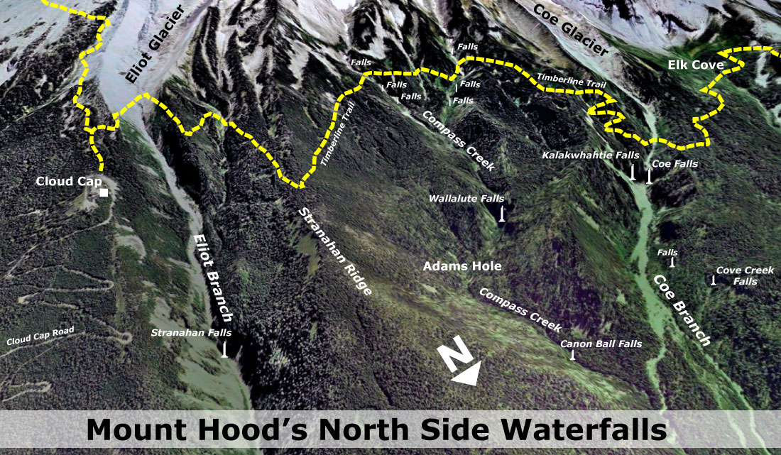
Pulling all of this together, the following is an oblique view of the north side region showing all of the waterfalls in context: Stranahan Falls on the Eliot Branch, Wallalute and Canon Ball falls on Compass Creek, and Kalakwhahtie and Coe falls on the Coe Branch.
Also shown are a couple of unnamed tributary waterfalls in the Coe Branch canyon, and there are surely other waterfalls yet to be discovered in this seldom-visited area.
In an effort to close the chapter on this naming saga, I plan to provide the documentation from this article to the Oregon Board of Geographic Names (OBGN), in hopes that they can eventually look into the matter and perhaps correct the map error of more than a century ago.
Visiting the Waterfalls
The series of waterfalls described in this article are remote and difficult to reach. Visiting these waterfalls is only for expert explorers.
Wayne Harvey approached the Coe and Compass Creek falls from the Elk Cove Trail, dropping into the canyon just beyond the prominent Coe Canyon overlook. This required a rugged descent of nearly a thousand vertical feet, followed by challenging bushwhacks at stream level to the waterfalls.
1920s Visitors to Cloud Cap taking in the view of Stranahan Falls (just to the right of the small tree in front of the car) and Mount Hood from Inspiration Point
Stranahan Falls can be seen from Inspiration Point, but represents a potentially dangerous descent into a canyon that has been destabilized by recent floods. However, there are good views of the falls from a boot path that descends to a rocky overlook, just below Inspiration Point on the Cloud Cap Road.
One of the trail concepts in the Mount Hood National Park Campaign calls for a “low trail” paralleling the Timberline Trail. On the north side of Mount Hood, this new route would connect the dots among the string of waterfalls described in this article. Wayne Harvey’s remarkable images of the waterfalls only underscore the case for providing access to these beautiful places, hiding in plain sight.
Acknowledgements: special thanks to Wayne Harvey for the use of his images and field reports, and to both Wayne Harvey and Bryan Swan of the Northwest Waterfall Survey for their help in untangling the history of geographic names in the Eliot, Compass and Coe drainages.
For this article, I’ll stray from WyEast country a bit, if only to illustrate just why those who love the Oregon landscape ought to be distrustful of the Oregon Department of Transportation (ODOT) when it comes to respecting Oregon’s scenic and cultural legacy. Sadly, the agency simply isn’t up to the job.
Case in point: the not-quite-finished Goose Rock Bridge, located on Highway 19 where it crosses the John Day River. The site seems like a no-brainer for what is called “context sensitive design” in engineering parlance. More plainly stated, this means moving away from the 1960s highway builder’s mentality of building over-engineered, one-size-fits-all concrete monoliths that pave over the local character of a place.
For the engineers who designed the new Goose Rock Bridge, the evidence that something other than a miniature version of a California freeway ramp was in order was painfully obvious:
• Located in a National Monument? Check.
• Crossing the John Day, one of Oregon’s premier scenic rivers? Check.
• Located on an Oregon Scenic Byway? Check.
• Replacing a historic highway structure? Check.
• Minimal traffic volumes? Check.
• Likely to serve bicycles and pedestrians? Check.
Any of these simple checks should have sent the engineers back to the drawing board. Instead, the public received another ugly, industrial eyesore for the millions in Oregon tax dollars spent on this blunder.
Sheep Rock rises above the John Day River, just upstream from the new bridge
So, the damage is done on the John Day River at Goose Rock, and now we’re stuck with a stinker of a bridge for the next several decades: the real question is whether ODOT can stop building goose eggs like this? The answer is yes… maybe.
What’s wrong with the design?
Why is the new bridge such a stinker? To answer that question, we can reflect on the bulleted list of design considerations listed above:
Respect the location: The project is in a National Monument, along an Oregon Scenic Byway and crosses a famed, wildly popular whitewater river. As such, the bridge should have embraced National Park Service (NPS) design elements. This is a no-brainer, and there is plenty of guidance to help ODOT with the aesthetic features, had anyone thought to look. This simple step could have made the new bridge an asset to the John Day National Monument, not an eyesore.
The famed Blue Basin is a less than a mile from the new bridge
Respect the history: The new structure replaces a bridge constructed in 1941 that may have been structurally obsolete, but had plenty of charm and historic significance to complement the setting. The original structure featured graceful, fluted concrete posts anchoring ornate, painted steel balustrades and railings. The under structure was a simple pier design, but included a graceful apron of decorative concrete arches.
Had context-sensitive design been a consideration in this project, these historic details would have been a major element in the design of the new bridge. Instead, the character of the old bridge is now but a memory.
Design for the users: The Goose Rock Bridge carries an tiny amount of traffic by urban standards — only about 300 vehicles per day, which is the equivalent of a typical suburban cul-de-sac serving just 30 homes. Just one lane of the Banfield Freeway carries this much traffic every ten minutes.
The new bridge: freeway ramp to… nowhere?
While the bridge does carry trucks, the massive design of the new structure is still wildly over-built, with freeway-scale Jersey barricades for railings that make the new bridge hostile to the cyclists, hikers and fishermen who cross this bridge while visiting the National Monument and the John Day River. Even passenger cars are punished by the new design, with the absurd concrete freeway barricades blocking views of the river for passing motorists.
Would you walk (or pedal) across this bridge?
Instead of the meager striped shoulder that supposedly serves bicycles and pedestrian, the design should have included a segregated sidewalk. This would have been a nice addition for the walkers, fishermen and less confident cyclists crossing the structure, and would have invited stopping on the bridge to admire the view — something no user would be safe doing on the new structure.
Who’s Fault is it?
Where did this simple project to replace the old bridge get off track? That’s hard to know (assuming it was ever on track). The project is one of hundreds funded through a $2 billion bridge replacement program known as the Oregon Transportation Investment Act (OTIA).
Republicans who controlled the Oregon legislature at the time OTIA was passed into law insisted that the design work for projects be sent off to private consulting firms, in this case, two firms — OTAK and Wildish Standard Paving — where the design decisions were likely made, before receiving a final approval from ODOT.
It is a poorly kept secret that the consulting firms receiving the bulk of the OTIA bridge contracts lured many of ODOT’s bridge engineers into the private sector to do the “private” work — usually with better salaries than they might have earned designing the same bridges at ODOT. While ODOT gets the bulk of the blame for accepting the lousy design of the new Goose Rock Bridge, the consultants deserve a good share of the shame, too. For its part, OTAK boasts on its website that:
Otak is the lead consulting engineer for Wildish Standard Paving on this $40 million design-build project along US395 in Eastern Oregon. Spanning nearly half the state, this project includes replacement of seven bridges along a sensitive waterway and wild and scenic corridor.
Nice words, but there is nothing in the design that suggests OTAK ever took the “sensitive waterway” and “wild and scenic corridor” into consideration when building the new bridge. It’s a firm that has done better work, elsewhere, and should have known better in this case, too.
Designed for 30,000 vehicles per day… but carrying only 300. Cyclists and pedestrians are on their own.
Another problem was probably the way in which projects were funded. Many of the bridge projects funded through OTIA followed ODOT’s “design-build” process, which combines the design, engineering and construction into a single contract.
In this case, ODOT “bundled” seven bridges scattered across the John Day country into a single ODOT contract, which unfortunately means more blunders like the Goose Rock Bridge can be expected (if they haven’t already been built). It also means that meaningful public involvement is a remote possibility, since the whole point is to speed up project delivery and cut costs wherever possible.
When will the Goose Eggs stop?
It will take a lot to pull ODOT onto a more enlightened path. This is evidenced by the $120 million the agency has already spent to devolve the design for the Columbia River Crossing to the worst conceivable option, as well as dozens of smaller eyesores built under the OTIA bridge program.
One possibility for the future is to simply remove the aesthetic design elements of project planning from the grasp of ODOT engineers, and handing this work over to architects or volunteer design panels, instead. Another is to establish a design auditor within the agency with the staffing and authority to “stop the assembly line” before construction money flows to badly designed projects.
Jersey barricades belong on the Banfield, not on John Day River bridges
Yet another option is to simply recruit and employ engineers versed in the basics of context sensitive design, and demand the same of the relatively short list of private contractors that ODOT keeps on retainer. In the long term, this is the best option, but would first take recognition by ODOT that a problem exists. Clearly, the agency isn’t there, yet, as evidenced by the Goose Rock Bridge travesty.
There are a few bright spots at ODOT, however, including several in WyEast country. These include the new Government Camp bridge over US 26 and several recent bridge replacements along I-84 in the Columbia River Gorge Scenic Area. In both cases, consistent pressure from local advocates was part of the puzzle that led to better design.
In the case of the Gorge, ODOT has adopted a comprehensive architectural guidance for engineers on all aspects of highway design has been an invaluable tool, and could be applied statewide in scenic areas, like the John Day National Monument.
Context-sensitive design from the I-84 Corridor Strategy guidelines for the Columbia Gorge
In the meantime, hold your breath. It’s nearly impossible to spot a bad project in the byzantine ODOT design process before the construction contracts are let, and another concrete eyesore appears on the landscape. We can only hope that ODOT projects currently lined up for US 26 and OR 35 along the Mount Hood Loop draw from the recent successes in the area, and not the old freeway engineer mindset that produced the Goose Rock Bridge goose egg.
Arrowleaf Balsamroot are the stars of the spring wildflower show
Each spring the parking lot at the Dog Mountain trailhead in the Columbia Gorge starts to look like Black Friday at a shopping mall: hundreds of hikers crowd the trail for the classic hike through steep meadows of blooming arrowleaf balsamroot. Who can blame them? The flower show is spectacular, even with the crowds.
But for those seeking a bit more solitude with their wildflowers — and equally impressive views — the hike up Bald Butte in the nearby Hood River Valley is a fine alternative to Dog Mountain. The blooms usually come a few weeks later here, toward the end of May and into June. Because Bald Butte lies well east of the Cascade crest, the weather is usually better here, too.
The beautiful flower display on Bald Butte frames sweeping views of Mount Hood and the Hood River Valley
Measured in travel time from the heart of Portland, Bald Butte is a bit more distant than Dog Mountain. But the somewhat longer drives includes the gorgeous final stretch up the Hood River Valley, which is a treat in itself for hikers.
Diamond in the Rough
So, why doesn’t the Bald Butte trail see more boot traffic? One answer could be the upper trailhead, which is accessed off Surveyors Ridge Road and is the unintended gateway for 4x4s, dirt bikes and quads to illegally enter the area. While the area trails are only open to hikers, bikes and horses, motorized vehicles continue to be a problem.
This 4x4 is driving illegally on the “trail” to Bald Butte
A second reason for fewer visitors at Bald Butte might be the quality of the “trail” from the upper trailhead to the summit. Here, the route officially follows the Surveyors Ridge Trail (No. 688), though the “trail” is actually an old dirt road that once served as access to a fire lookout on the summit of Bald Butte.
The road is not only difficult to enforce as a “trail”, it also provides a substandard hiking surface in many spots, with the illegal OHV use destroying the surface, and leaving a difficult mess of loose cobbles and ruts for hikers to navigate.
OHV damage to the “trail” at Bald Butte will likely require some sections to simply be closed and rehabilitated
Finally, the trail is bisected by the monstrous Bonneville Power Administration transmission corridor. This visual and ecological calamity came into being with the completion of The Dalles Dam in 1957, and is only surpassed by the dam, itself, for the negative impacts it brings to the area (see [link= https://wyeastblog.wordpress.com/2009/02/03/transmission-corridor-redux/%5DTransmission Corridor Redux[/link]
The BPA Transmission Corridor is a manageable eyesore
Despite these drawbacks, the hike is a spectacular one, and fills a unique niche by providing an early season mountain hike when many trails in the area are still snowed in.
More importantly, there are straightforward solutions for resolving these drawbacks, and thus the Bald Butte trail represents a diamond-in-the-rough opportunity, just waiting to shine. This article proposes a few the solutions that could greatly enhance the hiking experience on Bald Butte, while also mitigating some of the environmental problems that currently exist.
A new vision for Bald Butte
Spring wildflower spectacle on the slopes of Bald Butte
This proposal addresses four issues that currently diminish the Bald Butte trail:
1. Formalizes and manages the upper trailhead to prevent OHVs from straying onto trails.
2. Replaces sections of “road” that currently serve as “trail”.
3. Improves the hiking experience where the route crosses the BPA corridor.
4. Establishes a loop trail system that allows for better mixing of bikes and hikers.
Above all, the new trail connections in this proposal enhance the scenic experience for hikers by simply bringing them through more of the open meadows that are the main attraction — just as the newer, redesigned trails on Dog Mountain focus on the meadows and river views.
The following maps show these key elements for improving the trails at Bald Butte. The major new addition would be a loop trail starting at the lower end of the Oak Ridge Trail, and climbing the open slopes of Bald Butte.
The Surveyors Ridge Trail from the upper trailhead to the summit, where it follows the old road, would be converted to become a true trail. The new sections would be built across the BPA Corridor and along the south summit approach to Bald Butte. The current dirt road segments could then be completely decommissioned, giving the butte a much-needed rest from off-highway vehicles.
The BPA corridor, itself, would also be managed differently. Under this proposal, the Bonneville Power Administration would designate a scenic unit where the transmission corridor passes over the shoulder of Bald Butte. The agency would then manage the vegetation under the transmission lines with an eye toward integrating the corridor with the adjacent forests and meadows, and providing the best possible hiking experience.
This element of the proposal could be a pilot project for better management of BPA tranmission corridors in other areas, with new best-management practices developed to address OHVs, dumping, invasive species and other nuisances that tend to follow the BPA corridors. The proposed scenic unit is shown in purple on the proposal maps.
The main draw in the proposal would be a new trail crossing the open slopes of Bald Butte. This is an exceptionally scenic area, and the trail concept could be patterned after the “new” trail on Dog Mountain, with an eye toward creating a world-class hiking experience.
In addition to the spring wildflower spectacle, this expanded trail system on Bald Butte would provide a nearly year-round hiking and biking opportunity. The loop design would also allow for bikes to remain on the Oak Ridge Trail, with the new trail limited to hikers. This would allow hikers looking for a loop trip to use both trails, but reserving the new route for those uneasy with shared hike/bike routes.
Finally, the upper trailhead would be retained in this proposal, despite the problems it currently brings with illegal activity. The short access road to the trailhead is unsigned, poorly maintained and the surrounding area is in a raw, semi-developed state that sets the stage for the unlawful activities that occur here.
To help remedy the situation, the trailhead could be formalized and improved to appeal to legitimate forest visitors — families looking for a shorter hike or bike to the summit of Bald Butte or along the Surveyor’s Ridge Trail, for example. Despite the presence of the BPA towers, the view toward Mount Hood from the upper trailhead is sweeping, and could even serve as a picnic site or more formal viewpoint for motorists touring the area.
How to Visit Bald Butte Now
There is no need to wait until the trails at Bald Butte have been improved, as the current routes provide for terrific hike, especially in spring and early summer.
The Oak Ridge Trail serves as the first leg of the hike, beginning from the trailhead of the same name, just off Highway 35. The route then follows the Surveyors Ridge Trail past the BPA corridor and to the summit, following the old lookout road for the final segment.
A detailed hike description, with maps and photos is provided on the Portland Hikers.org Field Guide:
Last week, the Forest Service and Oregon Department of Transportation (ODOT) jointly announced that the main trunk of one of two remaining Barlow Road Tollgate heritage maple trees would be coming down soon:
“A 130-year-old bigleaf maple, which marks the spot of the western-most tollgate of the historic Barlow Road, has substantial decay and poses a hazard to travelers on U.S. Highway 26 (Mt. Hood Highway). The tree is planned to be felled within the next three weeks.”
On its face, the decision is both reasonable and expected. The maples were planted in the 1880s by tollgate keeper Daniel Parker, and have lived the typical lifespan of our native bigleaf maple. A third maple apparently survived until the mid-1990s, and along with the tree that will soon be removed, framed the old tollhouse that once stood on the north side of the tollgate (where the highway is located, now).
The large trunk on the right will be removed, but the three smaller trunks on the left will be spared
The good news is that the tree will live on, through suckers that have grown to become three separate trunks – a typical form for bigleaf maples. From the press release:
“The old bigleaf maple to be felled has several stems: a main stem, with a diameter of 25 inches, and three smaller 4- to 6-inch diameter stems growing from the base of the trunk. These three smaller stems, each about 25 feet tall, will be untouched by the project, while the decaying main stem will be reduced to a height of two to three feet.”
Hopefully the companion tree on the south side of the gate will also survive through new stems someday growing from its base. This is the larger of the two trees, and because of its distance from the highway, will be allowed to grow undisturbed.
The remaining maple is far enough from the road that it will be allowed to remain, undisturbed
As trees around Mount Hood go, the two maples at Tollgate aren’t particularly remarkable — there are plenty of larger, older and more impressive bigleaf maple trees growing in less traveled areas of the surrounding forests. The uniqueness of these trees, of course, is the tie to the Oregon Trail, itself, a piece of Amercian history that is deeply embedded in our cultural identity.
Sam Barlow’s Road
Most Oregonians know the story of Sam Barlow, and his daring expedition over the shoulder of Mount Hood with Joel Palmer in the fall of 1845, in search of a land route through the Cascades.
Sam Barlow and his legendary road
By 1846, the route the two men had scouted and led their own wagons over had become a business venture for Barlow: a notoriously rough toll road that thousands of Oregon settlers would travel over in the years that followed. Many described it as the worst part of their 2,000-mile journey.
The tollgate site marked by the twin maples was the final location of at least five tollgate sites that existed along the Barlow Road over the years, with this final tollgate operating from 1883 to 1918. The gatekeeper charged $5 per wagon, with smaller fees for livestock, foot travelers and even the first automobile, which arrived at the tollgate in 1903. This was a handsome price in its day, but for most travelers, it was also a one-time charge on the way to the Willamette Valley.
The Tollgate wayside fronts one of the few remaining Highway 26 segments that has remained largely unchanged little since the first highway was built in the 1920s
As the toll road era faded away in the early 1900s, plans for the first loop highway around the mountain were underway, and much of the new route followed the original Barlow Road when first leg was completed in the 1920s.
Because the Barlow Road had a number of evolving alignments over the years, many traces of the route survived the highway-building era, and can still be seen today. The original loop highway was used through the 1950s, and was then replaced with the modern alignment we know today.
The Future of Barlow Road… and Highway 26?
The tentative tone in the opening paragraph if this article stems from the terrible record ODOT and the Forest Service have in protecting the historic, scenic and environmental legacy of the Barlow Road corridor.
Highway 26 “improvement” just east of Tollgate in 2004
While the Forest Service and ODOT have made a reasonable case for removing the heritage maple at the Tollgate site, the agency has a long history of aggressive, senseless tree removals along the Mount Hood Loop. Most of this sad legacy stems from ODOT’s unstated objective to widen the highway to four lanes through the entire Mount Hood corridor at all costs — usually cloaked as a “safety” or “preservation” projects to ensure that their policy makers and the general public don’t get in the way of the underlying road widening mission that continues to drive the agency.
One strategy used by highway engineers to ease the path toward eventual road widening is to cut trees way back along highway sections in advance, as a divide-and-conquer strategy. The goal is to avoid jeopardizing a future road-widening project with public outcry over tree removal.
This practice is also rationalized under the “safety” banner, but actually encourage speeding by removing the traffic calming effect that a tree canopy creates. The use of street trees and landscaping in urban areas to discourage speeding is a widespread and fully accepted practice in the modern transportation design, but clearly hasn’t penetrated the ODOT offices yet.
Highway 35 “improvement” currently underway near Hood River Meadows is predictably cutting trees back from the roadway
In 2004, ODOT cleared the shoulders along several sections of US 26 in the vicinity of the Tollgate site, and one concern in hearing the news of the heritage tree is that this project is a precursor to tree removal along this final stretch of mostly original highway, where big trees still grow near the road.
The unstated ODOT mission to widen the loop highway to an urban freeway standard is described in detail in these earlier WyEast Blog articles:
Unfortunately, the projects described in these articles continue to advance, with a few cosmetic details thrown in to keep them moving. Sadly, they represent almost $30 million in public dollars that will make the highway a lot more like an urban freeway, while ignoring their own consultant recommendations for far less costly, more effective safety solutions.
The first phase of ODOT’s “safety and preservation” work is slated to begin just east of Tollgate this summer, and — right on schedule — the project has already been “updated” to include widening for a new westbound travel lane, along with “separate projects to remove select trees for safety reasons.” Just as predicted.
A New Vision for the Mount Hood Loop
The beautiful wayside at Tollgate is a great example of the very kind of feature that ought to be the focus of a tourism-oriented highway design along the Mount Hood Loop. Yet ODOT is about to make changes to the highway that will make it much less friendly for visitors. Is there an alternative?
1950s Mount Hood Loop wayside at White River
In a coming piece, I’ll present a different vision for the Mount Hood Loop that rejects the current ODOT plans for road widening, and the dubious “safety” claims that ODOT officials are using to cloak nearly $30 million in projects that will turn the corridor into a freeway.
This alternative vision will offer a less costly, sustainable long-term design that actually IS safer, and also much more enjoyable for the visitors to the mountain that drive the local economy.
Just east of Bridal Veil on the Historic Columbia River Highway, a colony of white-barked Quaking Aspen (Populus tremuloides) suddenly appear along the road, seemingly transported from somewhere in the Rocky Mountains. Though these are North America’s most widespread tree species, they are uncommon in Western Oregon.
Many who spot these unlikely trees might reasonably assume they were intentionally planted here, given the nearby residential district. That’s possible, but it’s more likely that this is a native stand, one of only a few sprinkled on the western fringes of the aspen range, where it extends south from Canada along the eastern crest of the Cascades.
Quaking Aspen appear suddenly along the Scenic Highway near Bridal Veil (Google Streetview)
The stand is easy to find: drive one-third mile beyond the Angels Rest trailhead in the Bridal Veil area and watch for the trees on the south side of the road. There’s room to pull off, but use caution before wading in — this might be the only Aspen grove in Oregon with knee-deep poison oak! The stand is also fringed with lupine, coltsfoot and many other wildflowers in mid-spring, making for a dramatic scene.
Why Here?
Topographic maps give a hint as to why Aspen would grow here: marshy, river bottom soils, cool mountain air flowing off Larch Mountain and down Coopey Canyon and the generally brisk Gorge winters mimic prime aspen habitat. The grove also appears to be on public land, within Shepperds Dell State Park (see map, below).
The Quaking Aspen grove is near Coopey Creek, below Angels Rest
It’s hard to know the future of Oregon’s aspen trees, given the expected effects of climate change on most northern species. The following map shows just how fragile the aspens along the Cascade Range are compared to the broad habitat found in the Rockies, Great Lakes region and Canada:
North American extent of Quaking Aspen (Wikimedia)
Even more isolated and fragile are the groves that dot the basin and range country of Southeast Oregon. These are the aspens growing on alpine islands in the desert, including Steens Mountain, Hart Mountain and a few other tall peaks in the high desert country.
Ecology of the Aspen
The name “Quaking Aspen” comes from the unique trembling that the slightest breeze creates among the leaves of Aspen trees. This is also where the botanical name of “tremuloides” is derived.
The “quaking” comes from flattened petiole, or stem, that connects the leaves to tree branches, and vibrates in the wind. The soft rustling is unmistakable to anyone who has spent time in Aspen country. Though Aspen are famous for their brilliant yellow fall color, the Gorge grove tends to be a paler yellow, possibly reflecting the milder fall temperatures at the site, compared to typical Aspen habitat.
Quaking Aspen leaves
Quaking Aspen reproduce mostly through root sprouts, with the young trees called “clones”, since they are genetically identical, and usually still connected to the parent tree. Whole groves of Aspen often consist of clones from a single originating tree, and share a single root system, and are thus called clone colonies.
This shared root system help explain why these colonies leaf out in spring and abruptly turn color in the fall as a complete unit, but often out of sync with nearby colonies running on their own clock.
Moss on Aspen trees: a uniquely Oregon thing?
The survival advantage of a clone colony can be seen in the Pando colony in Southern Utah, located high on the Colorado Plateau. Scientists estimate the 100-acre colony to have nearly 50,000 individual “stems” (trees) in the grove, all sharing a common root system. Amazingly, the root system is estimated to be at least 80,000 years old, with some scientists estimating the colony to be over million years old. This makes the Quaking Aspen both the oldest and largest organism on the planet, as defined by a continuously living DNA marker.
One disadvantage of clone colonies is that Aspen trees come in male and female varieties, and thus the clones in a colony are usually the same sex, making seed production more difficult.
Young Aspen clones emerging at the edge of the grove
Even when Aspen seeds are produced, they lack sufficient food and coating to make them durable enough to survive for long in harsh environments. This could be why Aspen rarely grow from seed, but also underscores the vulnerability of the species, since seed reproduction allows a species to migrate much more quickly in period of rapid climate change.
Aspen Die-Off
Older Aspens dying off in Southern Colorado (USFS)
In the mid-1990s, scientists began to notice a mass die-off in Quaking Aspen trees across the Western US. Often, the older trees in a grove were afflicted, but increasingly, entire clone colonies have died. There are a variety of theories about the decline, though most attribute it to a combination of changing climate and a century of fire suppression.
Like most western trees, Aspen are well adapted to fire, and quickly spring back after a burn, since the common root system of a colony is generally left unscathed, even if fire kills most of the trees growing from the root system. Under this theory, the die-off is a response to older Aspen groves simply outliving their viability, and abruptly falling victim to disease.
Entire Aspen groves dying in New Mexico (USFS)
Another theory focuses on the drought conditions that have plagued the west during the past two decades. Some scientists believe this has simply left Aspen too stressed to cope with insects and diseases that normally not be life-threatening to the trees. One study showed that more than 80% of the die-off has occurred in areas predicted to lose Aspen trees as a result of climate change — usually south-facing and lower-elevation habitats. This evidence also reinforces the risks that climate change will eventually bring for the Aspen forests.
Yet another theory is that over-grazing is causing the decline, with young tree sprouts being grazed before they can reach maturity, and replace older trees within a grove. In a unique study of wolves at Yellowstone, a variation on this research showed the same relationship where deer and elk populations were not checked by predators, causing a similar decline in Aspen colonies.
Though the die-off seems to be slowing in recent years, thanks to record rainfall in several previously drought-stricken areas, the damage has been extensive: Colorado has lost nearly 500,000 acres of aspen since the die-off began, or nearly 20 percent of its standing aspen. Other Rocky Mountain stands show similar damage, with scientists estimating that Aspen groves surviving today accounting for just 40% of what stood in the mid-1800s.
The Future of the Gorge Aspen?
Aspen can’t compete for long with Bigleaf Maple (seen in background) and other large species
The recent ecology of Aspen in the west is alarming, but researchers are busy looking for answers. In Oregon, studies are underway on the resiliency of Quaking Aspen in the Warner and Trout Creek mountains, and Oregon State University is providing ongoing research with The Aspen Project.
And what is the future of the Aspen grove near Bridal Veil? The good news is the trees seem to be on public land, and thus easier to protect and manage. New clones can also be seen growing at the edge of the stand, though the trees still face heavy competition from a thicket of underbrush, and a growing canopy of big conifers and Bigleaf Maple. In the long term, these Aspen won’t survive the competition unless the colony is actively managed to help them survive.
The western-most Quaking Aspen grove?
Other small Aspen stands dot the Gorge and the western foothills of Mount Hood, including one emerging stand along US 26, just east of Gresham, that might just be the western-most in the state. Much larger stands flank the east slope of the Cascades in places like the Hood River Valley, Metolius River and Klamath Lake.
While these isolated stands are small and remote from the prime Aspen habitat of the Rockies and Canada, that could be a very good reason to help them survive: it’s possible that these intrepid Oregon Aspen will be better situated to survive climate change, and may represent a genetic insurance policy for the species.
Scientists are learning much about Aspen and how to perpetuate the species in the face of the die-off. Hopefully, Oregon’s public land managers will also apply these lessons to the tiny, isolated healthy stands in places like the Gorge, as one more safeguard for an increasingly vulnerable species.
Mountain biking is a natural fit for the Gorge (Photo: Wikimedia Commons)
With the controversy (apparently) behind us on the now-defunct Cascade Locks casino proposal, conservationists have focused their Gorge concerns on a Nestle Corporation proposal: truck bottled water from a natural spring at a little-known fish hatchery on the edge of Cascade Locks (described in this WyEast Blog article)
The Nestle proposal is a bad idea on so many levels, and ought to be stopped. But the fracas over Nestles has overshadowed a very good idea known as the Cascade Locks International Mountain Bike Trail, or CLIMB. The concept is to simply build on the network of existing trails, old forest roads and a few new trails to create a world-class mountain biking destination, accessible from downtown of Cascade Locks.
Mountain bikers on a wintry Oakridge Trail (photo: Travel Oregon)
This proposal is exactly the kind of quiet recreation-oriented tourism strategy that put Hood River back on the map after the timber collapse in the early 1980s, and has the potential to revitalize Cascade Locks as well. The former mill town of Oakridge has kicked off a similar effort to foster bike tourism, advertising itself as the “Mountain Biking Capital of Northwest”, and bringing an impressive network of trails online over just a few years. These communities provide working examples for Cascade Locks in making a successful transition to a tourism-based economy.
Conservationists should be enthusiastically supporting the CLIMB idea, and any others like it that build on the natural and scenic character of the Gorge, as a counterpoint to the justified opposition to clunker schemes like the casino and Nestle plant that would harm the Gorge.
CLIMB West
The Cascade Locks proposal begins with a new trail traversing above the community from a western trailhead near the Bridge of the Gods to an eastern terminus at the Oxbow Fish Hatchery (where Nestle proposes to bottle the natural springs by the semi-truck load).
Along the way, the proposed trail would cross Dry Creek, intersecting the primitive access road that follows the creek upstream to beautiful Dry Creek Falls.
Curiously, the proposal does not incorporate this old road into the mountain bike network — a missed opportunity to close the route to ATVs and motorcycles that routinely use the road to loop onto the Pacific Crest Trail. Cyclists would likely find their way to the falls, of course, but including this road segment in the system would be a great way to transition the route (and surrounding area) to quiet recreation.
Dry Creek Falls
Another missing link in the western portion of the network is from the Oxbow Fish Hatchery to Herman Creek. While the terrain here is challenging, making this connection on trails — as opposed to following the freeway frontage road, as shown in the draft plan — could be critical to the viability of the network as a system based in Cascade Locks. The goal for the project should be for cyclists to start and end their tour in Cascade Locks, not at trailheads located east of town along forest roads (though that would certainly occur, as well).
Hopefully, the plan can at least include a long-term concept for making a new trail connection across Herman Creek to fully integrate the trail system with the town of Cascade Locks.
CLIMB East
Most of the proposed CLIMB network is located along the corridor between Herman Creek and Wyeth, with a combination of new trails and existing routes that would create a number of loops and interesting destinations, with trail access at several points along the way.
This part of the proposal envisions using Trail 400 and a short segment of the Herman Creek Trail as part of the network, a move that hikers might be leery of, but one that is highly workable and necessary to create trail loops. Trail 400 is gently graded and meticulously maintained, so is a good candidate for shared use. The segment of the Herman Creek Trail included in the proposal is really just an old road, so can easily accommodate the additional traffic and mix of bikes and hikers.
The eastern trail proposal would be anchored by the Herman Creek and Wyeth Campgrounds. While a plus for cyclists looking for a camping/cycling experience, this underscores the need for a direct trail connection from Herman Creek to Cascade Locks, and the potential economic benefit it would bring, including bike campers riding to town for a meal, beer or supplies.
Rustic bridge along Trail 400 at Gorton Creek
The Historic Columbia River Highway (HCRH) restoration project is considering adding the Herman Creek to Wyeth roadway to the historic highway corridor, a move that would provide a terrific complement to the mountain bike trail concept. Already, this road provides excellent opportunities for small trailheads accessing the proposed system, allowing for more route possibilities for cyclists and shuttles.
One missed opportunity in the eastern part of the proposal that could be both bold and iconic would be repurposing the Forest Service work center at Herman Creek to function as a trailhead base for cyclists. This historic structure dates back to the Civilian Conservation Corps era, but has been relegated to administrative uses by the Forest Service. The CLIMB proposal could turn this structure into a flagship facility for cyclists, possibility with a public-private lodge function patterned after the lodges at Timberline and Multnomah Falls.
Historic work center at Herman Creek
The old work center also features a nearly lost trail connection that switchbacks directly to the Herman Creek Campground (and shown on the CLIMB trail concept), providing a nice complement for cyclists camping in the area if the work center were to become some sort of base facility.
Thinking bit further outside the box, another opportunity could be to add the old quarry site at nearby Government Cove to the proposed trail network.
View from the beach at the Government Cove site
The quarry is on a peninsula that separates the Columbia River from the cove, and has the potential to be a terrific riding destination, especially for riders following street routes from Cascade Locks to the Herman Creek trailhead. It would also bring the CLIMB network to the river, which is currently a missing piece in the proposal. The property appears to be port-owned, so could be a natural fit, given the port’s role in advocating for the project.
Project Timeline
Since the project began in 2007, a feasibility study, conceptual trail plan and master trail plan have already been completed with funding support from the Port of Cascade Locks, City of Cascade Locks, and Hood River County.
The next step is to conduct an environmental review of the trail corridor. In late 2010, the Port of Cascade Locks reached an agreement with the U.S. Forest Service to perform the required National Environmental Policy Act (NEPA) analysis of the proposal using private consultants, since the Forest Service lacked the capacity to do this work in the near future. Several proposals to complete the work were received earlier this year, but at a cost of $170,000 to almost $400,000, were financially out of reach for the Port of Cascade Locks.
The Port and the USFS have since worked out a tentative agreement to allow this project to continue to move forward using limited Port funding to begin gathering environmental data, with the Forest Service taking over the environmental analysis in 2013, using this data.
Learn More & How to Help
For more information on the proposal, including more detailed maps, visit to the Port of Cascade Locks site here. You can also view photos of the proposed trail routes and promote the idea using the project’s Facebook link. Someday, we may have a world-class mountain bike network defining the economy in Cascade Locks, who knows?
But in the meantime, the best way to keep casinos and Nestle trucks from tainting the Gorge is to vote with your wallet, and simply to support local businesses in the Gorge that rely on tourism. If you traditionally stop somewhere in the Portland area for a beer or burger after a hike or trail ride, consider a stop in Cascade Locks, Stevenson or Hood River, instead.
Though no longer a well-kept secret, the relatively new Clackamas River Trail from Fish Creek to Indian Henry Campground provides a scenic, all-season alternative to the often crowded low-elevation trails in the Columbia Gorge. An added bonus is the impressive falls on Pup Creek — the main attraction for many who make this trip. But the trail also provides a unique, close-up look at a rapidly recovering forest ecosystem that burned less than a decade ago, and plenty of river scenery along the way.
The Fire Zone
In September 2002, the Bowl Fire swept through 339 acres of tall timber along the first mile or so of the Clackamas River Trail, just east of Fish Creek. Today, nine seasons of forest recovery have brought a rejuvenated understory with sun-loving wildflowers crowding the trail. While many trees were killed, a surprising number of the old giants survived, providing a living laboratory on the role of fire in our forest ecosystems.
White Clackamas iris (Iris tenuis S. Watson)
Along this section of trail, the fire has been especially beneficial to the rare Iris tenuis S. Watson, or Clackamas iris. This elegant wildflower occurs in both blue and white in its very narrow range. It is found along the Clackamas and Molalla Rivers, and nowhere else. These iris form beautiful drifts of white blossoms along the burned section of trail in late May and early June.
White Clackamas iris (Iris tenuis S. Watson)
Ancient Forests
Beyond the fire zone, the trail dips into an impressive stand of ancient forest, tucked into a shady grotto between 200-foot cliffs and the Clackamas River, at the confluence with the Roaring River. These centuries-old western red cedar and Douglas fir thrive in the boggy river bottom, well protected from the elements.
In spring, the air in this pocket of ancient forest is filled with the pungent (and unmistakable) aroma of skunk cabbage growing in the bog, while the sound of falling water reveals a string of delicate waterfalls cascading over the cliffs, and into the green grotto.
Looking down at ancient forest from a cliff-top viewpoint
After passing through this magical spot, the Clackamas River Trail climbs a steep, rocky bluff above this hidden forest, providing a unique opportunity to observe the big trees from different levels, as if riding an elevator.
Hiking The Trail
Guidebook descriptions vary, but by my estimate, the hike from Fish Creek to beautiful Pup Creek Falls is about 8 miles round-trip, with the rollercoaster trail gaining about 900 feet in elevation along the way as it climbs around several cliffs. Because the high point at Pup Creek is only 1,300 feet in elevation, the trail is usually open year-round.
The trail starts at the Fish Creek trailhead, located about 15 miles southeast of Estacada on Highway 224. The turnoff to Fish Creek is well marked, and is just past the Carter Bridge, Lockaby and Armstrong campgrounds.
Turn right onto Fish Creek road, pass the Fish Creek campground, cross the Clackamas on yet another bridge, then watch for the trailhead parking on the right, at the confluence of Fish Creek and the Clackamas. The trail begins at the far (south) end of the parking area, on the opposite side of the road, and is marked with a signpost.
The Fish Creek Trailhead
The path starts out wide and gentle, following a rustic dirt road to a small stream ford and dropping to the banks of the Clackamas. From here, the trail briefly rambles at river grade before entering the fire zone. Soon, the first uphill section begins as the trail climbs through the burn and over the first set of cliffs. On the bluff above the cliffs, white Clackamas iris line the trail in spring, along with many other wildflowers.
After the first crest, the trail descends to the river again, reaching a short pair of switchbacks just over a mile from the trailhead. Caution: watch for poison oak on both sides of the trail after the second switchback for a hundred yards or so — this is the only notable poison oak patch along the trail, but worth watching for (see map, above).
Section of the Clackamas River Trail
The trail follows the river bank only briefly, as the roller coaster trip through the burn section continues for another half-mile or so. Soon, the trail leaves the burn, and crosses the first in a series of small streams as it descends toward the ancient forest section, at about the 2-mile mark. There is a large riverside campsite among the giant cedars, here, and this makes a good spot to turn around if you are looking for a shorter hike.
Continuing through the ancient forest, the trail passes the skunk cabbage bog before crossing the largest of several streams dropping into the ancient forest grotto — and take a look upstream, too: a nearly hidden waterfall leaps off the cliffs beyond the big trees.
Next, the trail climbs a rocky bluff in a couple of switchbacks, providing that “elevator” view of the ancient forest, then a glimpse of the Roaring River confluence with the Clackamas, across the canyon. From here, the trail levels off, following the top of a bank of mossy cliffs for the next half-mile or so.
Steppingstone Creek
Soon, the trail crosses yet another lively creek, this one called “Steppingstone Creek” on the map for the helpful (and picturesque) series of stones that carry hikers across. From here, the final half-mile to the junction with the Pup Creek climbs very gently, with many river views.
The junction with the short spur to Pup Creek Falls is marked with a post, though no sign attached as of this spring. But you’ll know when you’re there: the junction is in a clearing under a transmission pylon. If you miss it, you’ll arrive at Pup Creek after 200 feet or so — by far the largest side stream on the hike, so you’ll know if you need to backtrack.
Upper Tier of Pup Creek Falls
The spur trail to the falls makes one quick switchback, but otherwise follows Pup Creek upstream to the dramatic amphitheater holding the 237-foot falls. In winter and early spring, the falls are particularly impressive, jetting a lot of spray to the small viewpoint at the end of the spur trail, so early season photographers should be prepared to battle the mist!
Because the falls are framed by a group of magnificent bigleaf maples, this is an ideal destination for late October or early November, when fall colors are peaking, and yellow maple leaves complement the bright yellow lichens on the walls of the amphitheater.
Traveler Tips
Highway Noise: on summer weekends, traffic on Highway 224 is more noticeable, so it’s a good idea to save this hike for mid-week, or the off-season for summer camping — or even winter, when you’ll have the place to yourself. That said, the highway proximity is rarely a distraction from the beautiful scenery on this trip.
“Leaves of three, let it be!”
Poison Oak: note the map, above — one enthusiastic patch of poison oak flanks both sides of the trail at the 1.2 mile mark, where the route descends through a short pair of switchbacks. The itchy stuff begins at the second switchback and continues for a couple hundred yards, but is easy to avoid if you know to watch for it.
Ticks: though rare, ticks have also been reported in the lower Clackamas canyon, so be sure to do a tick check after your trip — a good idea after any hike.
Camping: one of the handy aspects of this trail is the amazing selection of campgrounds in the vicinity — more than a dozen line the lower Clackamas. Two offer walking access to the trail: Fish Creek, near the trailhead described in this article, and Indian Henry, located about four miles beyond Pup Creek.
Forest Pass: the Fish Creek trailhead requires a Northwest Forest Pass, though this trailhead also has the option of a $5/day onsite payment for a day pass.
Over nearly a century, a summer rite of passage for thousands of Oregonians has been wading through the vertical-walled Oneonta Gorge to the beautiful falls hidden at the head of this slot-canyon. Since 1914, the old Columbia River Highway has brought a steady stream of visitors to the tempting view into the gorge from atop a graceful bridge.
More recently, this tradition has been tarnished by a series of natural events that have made the trip up Oneonta Gorge downright dangerous. First, a rockfall near the entrance to the Gorge in the late 1990s that left three pickup-sized boulders in the stream. Then a logjam formed behind the boulders, creating a slippery maze that hundreds of visitors each summer now struggle to navigate. Sadly, the danger prevents many families with children from even attempting the trip.
Two weeks ago, Portlanders were reminded of the dangers of the logjam when 22-year old hiker Hassan Roussi tragically — and needlessly — drowned after slipping on the logjam. In the spirit of preventing another tragedy at Oneonta Gorge, this article proposes a few solutions that address both the safety and quality of experience for visitors to this uniquely beautiful place.
Phase 1: Log the Logjam
The logjam must go. Immediately. Just saw it out, with chainsaws. The log pile took one life this month, and that’s one too many. Add the many unreported accidents that have likely occurred here, and it’s long overdue to simply remove the hazard.
The logjam and boulders that created it are a recent change at Oneonta
Forget any excuses about ecological concerns, the stream playing out its natural processes or budget constraints. The arguments in favor of removing the logjam are simple:
Environmental Impacts: hundreds of visitors hike through Oneonta Gorge every summer, so the stream is only as pristine as a few hundred pairs of feet allow. Running chainsaws during an “in water” window, when salmon and steelhead are not spawning, would be no more disruptive than any of the in-stream activities that occur across the Mount Hood National Forest every year — from road projects and culvert repairs to timber harvesting.
Natural Systems: it’s true that Oneonta Creek has flushed logs from the drainage for millennia, so why one just let the natural order play out? One simple reason is public safety, of course. Unless the Forest Service is willing to close the gorge to visitors, then clearing the logjam is the only responsible option.
But there is also an economic argument against allowing the logjam to grow: eventually, it could burst during a flood event, pushing a wall of rock, logs and water against the pair of highway bridges and railroad bridge, 100 yards downstream. The result could be disastrous for these historic structures. Removing the logjam just makes sense for ODOT.
Budget Constraints: this is the standard argument for doing nothing in our national forests, but at some point, the agency will be held legally accountable for allowing recreation hazards like the logjam to persist. It might take that kind of shock to the system for the Forest Service to put recreation — and especially safety needs — ahead of other forest projects. Given the logjam has been accumulating since the 1990s, there has been plenty of opportunity for the agency to remedy this problem.
Signs like this mark the bootpaths to Oneonta Gorge
Though these signs are mostly intended to absolve the USFS from legal action, they don’t excuse the agency for allowing this hazard to accumulate
Since the boulders that created the logjam will likely take decades (or centuries) to move downstream from Oneonta Gorge, periodic logging out of accumulated debris is the obvious and appropriate action. It should happen this summer — with the recent tragedy as the impetus for fast-tracking this project. There really is no excuse for waiting.
This is completely within the scope and funding capability of the Forest Service, but could also be a joint responsibility shared with ODOT, given the risk the logjam represents for the highway bridges. It’s also a moral imperative for public agency stewards, given the risk to visitors, and the fatal outcome last week.
After the present logjam is cleared, it should be logged out regularly, perhaps every year or two. Just as other trails in the forest are cleared of winter downfall, Oneonta Gorge should be regularly cleared of dangerous logs.
Phase 2: Embrace the Bootpaths
The safety concerns at Oneonta Gorge aren’t limited to the logjam. Visitors to the area are naturally tempted by the view into the gorge from the historic Columbia River Highway bridge over Oneonta Creek, and an inviting stairway leads down from the bridge to the west bank of the stream.
Oneonta Creek from the historic highway bridge
Once at the bottom of the stairs, visitors usually follow a braided system of unofficial boot paths that climb along the west wall of the canyon, formed by thousands of feet that have tramped this way for decades.
Much of this path is a watery slog in the rainy months, ending in a slippery scramble over rock outcrops, but all of it is completely salvageable as a trail, with careful design and some tread work.
The swampy boot path along the west approach to Oneonta Gorge
On the east side of the bridge, the Forest Service and ODOT have done their best to deny access to the stream, but with little success. Hikers have pushed beyond the piled logs and root wads at the “trailhead”, keeping the long-established route to the creek obvious and well-used.
Like the boot path along the west side of the creek, the east approach would be easily upgraded to a formal trail with a bit of design and tread work.
Nice try, but no dice: intrepid creek explorers aren’t stopped by this Forest Service blockade at the east approach to Oneonta Gorge
Together, the pair of boot paths flanking Oneonta Creek offer an excellent trail opportunity. Instead of trying to keep visitors out, a formal loop trail could safely bring less hardy hikers right to the mouth of Oneonta Gorge, while better managing some of the streamside impacts that the current maze of informal routes create.
The Proposal
Over the past decade, ODOT has spent a considerable amount restoring a section of the Historic Columbia River Highway at Oneonta Creek. The project included repaving the old highway and converting it to a hike/bike trail, with new parking for visitors and, most notably, restoring the old highway tunnel through Oneonta Bluff.
The beautifully restored Oneonta Tunnel
The highway restoration project was done beautifully, but many in the recreation community questioned the expense, given the many other unmet recreation needs in the area — the Oneonta logjam among them. Now is the time to backfill this project with trail improvements that connect the restored highway to the Oneonta Gorge — the main attraction in this area.
This proposal is simple: build on the beautiful restoration of the old highway and tunnel with a simple loop trail that follows the existing boot paths to the mouth of Oneonta Gorge. Coupled with removal of the logjam, these paths would lessen the impact of the many visitors who head up the gorge each summer. But the loop would also provide an excellent opportunity for less able hikers and families with children to take a short hike and see Oneonta Gorge, up close.
The loop would expand on several existing elements. First, it would take advantage of the historic stairway at the west end of the old highway bridge as the starting point for the loop, since most visitors already approach from this side of Oneonta Creek.
The stairway sets a wonderful rustic tone for the trail, more like a narrow footpath than a modern trail. This scale should be reflected in how the rest of the loop is designed, as it is perfectly scaled (and completely irresistible) to small children.
The wonderful old stairway at the west end of the Oneonta Bridge
The stairway is in amazingly good repair, given the neglect it has suffered for nearly a century. Though at least one of the railing posts needs to be restored, the stairway is completely serviceable in its present condition.
The bench at the top of the stairs is another important design element, and would be repeated at three new locations along the proposed loop. If the tiny stairway is a perfect magnet for children, the bench is ideal for less able visitors who might walk a portion of the loop, or perhaps just the first few feet of the trail.
The historic bench at the top of the old stairway
Using these basic design cues, the loop would formalize the boot paths on both sides of Oneonta Creek, with the new trail specifically designed for periodic flooding. This is because the entire riparian area between the walls of the gorge is subject to being submerged by high water, so trail elements would have to be designed accordingly.
An excellent design prototype already exists on another Columbia Gorge trail for accomplishing this all-weather design. The newly reconstructed trail at nearby Bridal Veil Falls provides an excellent blueprint for constructing a gravel-surfaced, flood-resistant trail. In the Bridal Veil design, the gravel trail is contained by a low border of basalt rocks (below).
The newly reconstructed Bridal Veil Falls trail
The proposal also calls for steps at a couple of rock outcrops along the west side of Oneonta Creek, and where the loop connects to the old highway on the east side of the creek. These would be mortared steps, in the “CCC” style seen throughout the Columbia River Gorge.
The most unusual element of this trail proposal is the means of crossing Oneonta Creek, at the mouth of Oneonta Gorge. In low water months, this is a slippery rock hop for visitors, but with some careful design and periodic maintenance, it could be designed as a more formalized series of steppingstones, providing a safe crossing over a much longer season.
The steppingstone design would be a durable alternative to a conventional footbridge (which would not be appropriate in this location, given the visual impact), and would also be in tune with the rustic nature of the trail, itself. Depending on water levels and ability, hikers could opt to stop at the crossing, or venture across to complete the loop.
Steppingstone crossing near Pup Creek Falls on the Clackamas River Trail
The Forest Service has also provided an excellent prototype for the steppingstone crossing, though not in the Columbia Gorge. Instead, the stream crossing pictured above, on the Clackamas River Trail, serves as an excellent blueprint. The stream flow in the scene is pictured in mid-winter, and similar to the summer flows on Oneonta Creek. A design like this is clearly feasible at Oneonta, though it would take periodic maintenance to ensure that steppingstones are adjusted or replaced, as needed, to maintain a safe crossing.
Finding a Creative Path Forward
Many of the ideas in these proposals require a break from conventional Forest Service practices, but “no action” at Oneonta Gorge isn’t a serious option. The Forest Service must address the logjam hazard, at a minimum.
Hiker visiting Oneonta Gorge in 1923
The loop trail proposal would move the Oneonta area from a band-aid, substandard level of recreation support to an experience that could be a memorable highlight for many Columbia River Gorge visitors. The public should expect no less from our agency stewards.
How to get there? Clearly, the Forest Service must re-allocate funding to address the safety issue at the logjam, and soon. ODOT could be a partner in this effort, given their interest in protecting the highway bridges downstream.
But it’s also possible that ODOT or the Oregon State Parks could partner with the Forest Service in developing the loop trail. The work could also be underwritten by a corporate sponsor, given the high profile of Oneonta Gorge as a destination along the old highway.
The only limit at Oneonta Gorge is our imagination — and the willingness of our public land stewards to step up to the challenge. Now is the time.
Brooks Meadow is one in a string of sunny meadows located on the gentle northern slopes of Lookout Mountain, just east of Mount Hood. At 35 acres, Brooks Meadow is among the largest, and has a long human history thanks to the water and forage it offers. It was likely visited for centuries by Native Americans, and in the late 1800s, was grazed with sheep following white settlement of the region.
Early settlement trails in the area connected the dots between meadows and water sources, with several converging at the Brooks Meadow by the early 1900s. A guard station was constructed at the upper end at that time, near the junction of three trails at the north edge of the meadow. Later, the trails became primitive forest roads.
Brooks Meadow was surrounded by clearcuts by the 1980s
By the 1950s, sheep and cattle grazing in the Lookout Mountain area was on the decline, giving way to a boom in commercial logging. Timber harvests focused on the big ponderosa and larch stands unique to the east slopes, and mills in the area thrived. The timber boom hit its peak in the 1980s, when miles of logging roads and hundreds of clearcuts transformed the slopes of Lookout Mountain.
When the sawdust settled in the early 1990s, Brooks Meadow was somehow spared, a lush island in a forest that had been almost completely logged in all directions. By sheer luck, when the commercial logging boom swept the area, the old primitive road and trail system was mostly bypassed or destroyed by the modern, paved roads that carries logs to the mills.
A thin veil of trees were spared along the periphery of Brooks Meadow
At Brooks Meadow, a new paved route was built around the north side of the meadow (shown above), bypassing the historic dirt track through the center of the meadow. The Dufur Mill Road was also paved, and routed just south of the meadow, proper.
Thankfully, the relocated roads kept the steady stream of log trucks out of the meadow, and allowed the fragile ecosystem to survive the logging era relatively intact. In fact, the curtain of trees that was spared along the margins largely hides the meadow from today’s travelers, allowing Brooks Meadow to remain surprisingly unknown.
Old topographic maps still show the abandoned dirt roads and former Guard Station at Brooks Meadow
When the paved roads were built, the primitive roads through the meadow were simply abandoned, and never properly decommissioned. In the intervening years, these abandoned roads have begun to reforest, thanks to the drainage that keeps the old roadbed drier than the surrounding meadow, and survivable for trees.
A closer view (below) of Brooks Meadow shows the abandoned road, and the dotted line of young trees that have begun to grow along the old roadbed. The location of the former guard station that once stood here is also shown.
The old road through Brooks Meadow is revealed by the young trees growing along it
Many of the meadows in the Mount Hood area are shrinking, thanks in part to a century of fire suppression and climate changes that allow for gradually encroaching forests. For Brooks Meadow, the threat comes from within, as well, with the strip of forest along the old road threatening to divide-and-conquer the meadow with reforestation.
This doesn’t have to happen, of course. The purpose of this article is to prod the U.S. Forest Service to consider a brushing project to remove the young trees along the old roadbed, and perhaps consider changes to the road’s drainage features that would help the old roadbed blend into the meadow, once again.
The brushing project is straightforward: there are about 60 young trees scattered along the old road, and they are small enough to removed by volunteers armed with bow saws and loppers. The drainage project would likely require more work, but could still be done by volunteers, assuming it is akin to trail maintenance work using hand tools.
Here is my offer to the U.S. Forest Service: I will assemble work crews of 10-12 volunteers for the brushing and drainage work needed to save Brooks Meadow. I believe the brushing could be done in a single day, and the drainage work in 2-3 volunteer days. Let’s get it done – we just need the green light from you!
Visiting Brooks Meadow
The best time to visit Brooks Meadow is in June and early July, when the wildflowers are at their best. In many spots, the flowers are waist-deep, and you will be surrounded by the sound of buzzing bees, singing birds and perhaps even spot elk or deer. There is no formal trail, but the going is easy if you follow the tree line along the edges of the meadow.
Elk grazing in the upper section of Brooks Meadow in 2009
The route begins at the pullout “trailhead” at the west end of the meadow (see driving instructions, below). The best way to tour the meadow is clockwise from the pullout, following just inside the treeline. This will keep your feet fairly dry, and protect the most pristine inner portions of the meadow from human traffic.
In the clockwise loop around the meadow, you will be rewarded with mountain views from the upper end, and huge drifts of wildflowers in early summer. Autumn is also a beautiful time to visit the meadow, though you should wear hunters colors whenever hiking on the east side in fall. In morning and evening, there are often elk and deer browsing in the meadow. Be forewarned not to approach elk herds — simply enjoy them from a distance.
One uncommon plant to look for in the meadow is Agoseris elata, or tall agoseris. This plant is in the sunflower family, and looks a bit like a dandelion blossom on steroids. Agoseris elata grows in just two places in the entire Mount Hood National Forest — Brooks Meadow and nearby Bottle Prairie.
How to Get There
Brooks Meadow is located just off Forest Road 44, east of Mount Hood. Follow Oregon 35 from either Hood River or US 26 to the Forest Road 44 junction. Turn east, and follow Road 44 uphilll for several miles to the obvious intersection with Forest Road 17, where Forest Road 44 abruptly turns right. Continue straight at this intersection, onto Road 17, and immediately watch for a pullout just 100 yards from the intersection.
(There are no restrooms or water sources at this informal trailhead. The nearest facilities are at the Sherwood campground, located along Highway 35, north of the Road 44 junction)
Postscript
After publishing this article, I noticed that the Forest Service and City of The Dalles have been busy posting the boundaries of The Dalles Water Watershed, again, including the informal trailhead at Brooks Meadow.
At least the shooters appreciate the new targets posted at Brooks Meadow
It’s a bit hard to take the closure seriously (most don’t, actually), given how the agencies have carved up this once pristine area with miles of logging roads and hundreds of clearcuts. More absurd is the fact that the “protected” stream flowing from the meadow is soon piped under paved Brooks Meadow Road in an open culvert — apparently, an area where protection isn’t required. Beer cans tossed in the culvert from passing pickup trucks complete this ironic picture.
So, use your judgment in visiting Brooks Meadow. While it’s hard to believe that hikers visiting the meadow to appreciate its beauty would actually be prosecuted (and spend the advertised six months in jail and a $500 fine, no less!) the posted closure is for real, unfortunately.