Gorge Aspen Colony

Quaking Aspen grove near Bridal Veil

Just east of Bridal Veil on the Historic Columbia River Highway, a colony of white-barked Quaking Aspen (Populus tremuloides) suddenly appear along the road, seemingly transported from somewhere in the Rocky Mountains. Though these are North America’s most widespread tree species, they are uncommon in Western Oregon.

Many who spot these unlikely trees might reasonably assume they were intentionally planted here, given the nearby residential district. That’s possible, but it’s more likely that this is a native stand, one of only a few sprinkled on the western fringes of the aspen range, where it extends south from Canada along the eastern crest of the Cascades.

Quaking Aspen appear suddenly along the Scenic Highway near Bridal Veil (Google Streetview)

The stand is easy to find: drive one-third mile beyond the Angels Rest trailhead in the Bridal Veil area and watch for the trees on the south side of the road. There’s room to pull off, but use caution before wading in — this might be the only Aspen grove in Oregon with knee-deep poison oak! The stand is also fringed with lupine, coltsfoot and many other wildflowers in mid-spring, making for a dramatic scene.

Why Here?

Topographic maps give a hint as to why Aspen would grow here: marshy, river bottom soils, cool mountain air flowing off Larch Mountain and down Coopey Canyon and the generally brisk Gorge winters mimic prime aspen habitat. The grove also appears to be on public land, within Shepperds Dell State Park (see map, below).
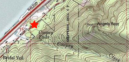
The Quaking Aspen grove is near Coopey Creek, below Angels Rest

It’s hard to know the future of Oregon’s aspen trees, given the expected effects of climate change on most northern species. The following map shows just how fragile the aspens along the Cascade Range are compared to the broad habitat found in the Rockies, Great Lakes region and Canada:

North American extent of Quaking Aspen (Wikimedia)

Even more isolated and fragile are the groves that dot the basin and range country of Southeast Oregon. These are the aspens growing on alpine islands in the desert, including Steens Mountain, Hart Mountain and a few other tall peaks in the high desert country.

Ecology of the Aspen

The name “Quaking Aspen” comes from the unique trembling that the slightest breeze creates among the leaves of Aspen trees. This is also where the botanical name of “tremuloides” is derived.

The “quaking” comes from flattened petiole, or stem, that connects the leaves to tree branches, and vibrates in the wind. The soft rustling is unmistakable to anyone who has spent time in Aspen country. Though Aspen are famous for their brilliant yellow fall color, the Gorge grove tends to be a paler yellow, possibly reflecting the milder fall temperatures at the site, compared to typical Aspen habitat.
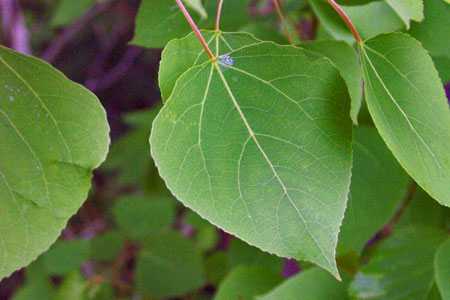
Quaking Aspen leaves

Quaking Aspen reproduce mostly through root sprouts, with the young trees called “clones”, since they are genetically identical, and usually still connected to the parent tree. Whole groves of Aspen often consist of clones from a single originating tree, and share a single root system, and are thus called clone colonies.

This shared root system help explain why these colonies leaf out in spring and abruptly turn color in the fall as a complete unit, but often out of sync with nearby colonies running on their own clock.
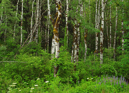
Moss on Aspen trees: a uniquely Oregon thing?

The survival advantage of a clone colony can be seen in the Pando colony in Southern Utah, located high on the Colorado Plateau. Scientists estimate the 100-acre colony to have nearly 50,000 individual “stems” (trees) in the grove, all sharing a common root system. Amazingly, the root system is estimated to be at least 80,000 years old, with some scientists estimating the colony to be over million years old. This makes the Quaking Aspen both the oldest and largest organism on the planet, as defined by a continuously living DNA marker.

One disadvantage of clone colonies is that Aspen trees come in male and female varieties, and thus the clones in a colony are usually the same sex, making seed production more difficult.

Young Aspen clones emerging at the edge of the grove

Even when Aspen seeds are produced, they lack sufficient food and coating to make them durable enough to survive for long in harsh environments. This could be why Aspen rarely grow from seed, but also underscores the vulnerability of the species, since seed reproduction allows a species to migrate much more quickly in period of rapid climate change.

Aspen Die-Off

Older Aspens dying off in Southern Colorado (USFS)

In the mid-1990s, scientists began to notice a mass die-off in Quaking Aspen trees across the Western US. Often, the older trees in a grove were afflicted, but increasingly, entire clone colonies have died. There are a variety of theories about the decline, though most attribute it to a combination of changing climate and a century of fire suppression.

Like most western trees, Aspen are well adapted to fire, and quickly spring back after a burn, since the common root system of a colony is generally left unscathed, even if fire kills most of the trees growing from the root system. Under this theory, the die-off is a response to older Aspen groves simply outliving their viability, and abruptly falling victim to disease.

Entire Aspen groves dying in New Mexico (USFS)

Another theory focuses on the drought conditions that have plagued the west during the past two decades. Some scientists believe this has simply left Aspen too stressed to cope with insects and diseases that normally not be life-threatening to the trees. One study showed that more than 80% of the die-off has occurred in areas predicted to lose Aspen trees as a result of climate change — usually south-facing and lower-elevation habitats. This evidence also reinforces the risks that climate change will eventually bring for the Aspen forests.

Yet another theory is that over-grazing is causing the decline, with young tree sprouts being grazed before they can reach maturity, and replace older trees within a grove. In a unique study of wolves at Yellowstone, a variation on this research showed the same relationship where deer and elk populations were not checked by predators, causing a similar decline in Aspen colonies.

The phenomenon is now known collectively as “Sudden Aspen Decline”, and is the focus of much concern among researchers.

Though the die-off seems to be slowing in recent years, thanks to record rainfall in several previously drought-stricken areas, the damage has been extensive: Colorado has lost nearly 500,000 acres of aspen since the die-off began, or nearly 20 percent of its standing aspen. Other Rocky Mountain stands show similar damage, with scientists estimating that Aspen groves surviving today accounting for just 40% of what stood in the mid-1800s.

The Future of the Gorge Aspen?
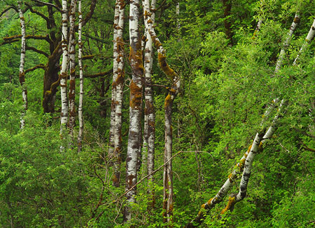
Aspen can’t compete for long with Bigleaf Maple (seen in background) and other large species

The recent ecology of Aspen in the west is alarming, but researchers are busy looking for answers. In Oregon, studies are underway on the resiliency of Quaking Aspen in the Warner and Trout Creek mountains, and Oregon State University is providing ongoing research with The Aspen Project.

And what is the future of the Aspen grove near Bridal Veil? The good news is the trees seem to be on public land, and thus easier to protect and manage. New clones can also be seen growing at the edge of the stand, though the trees still face heavy competition from a thicket of underbrush, and a growing canopy of big conifers and Bigleaf Maple. In the long term, these Aspen won’t survive the competition unless the colony is actively managed to help them survive.

The western-most Quaking Aspen grove?

Other small Aspen stands dot the Gorge and the western foothills of Mount Hood, including one emerging stand along US 26, just east of Gresham, that might just be the western-most in the state. Much larger stands flank the east slope of the Cascades in places like the Hood River Valley, Metolius River and Klamath Lake.

While these isolated stands are small and remote from the prime Aspen habitat of the Rockies and Canada, that could be a very good reason to help them survive: it’s possible that these intrepid Oregon Aspen will be better situated to survive climate change, and may represent a genetic insurance policy for the species.

Scientists are learning much about Aspen and how to perpetuate the species in the face of the die-off. Hopefully, Oregon’s public land managers will also apply these lessons to the tiny, isolated healthy stands in places like the Gorge, as one more safeguard for an increasingly vulnerable species.

Clackamas River Trail

Pup Creek Falls on the Clackamas River Trail

Though no longer a well-kept secret, the relatively new Clackamas River Trail from Fish Creek to Indian Henry Campground provides a scenic, all-season alternative to the often crowded low-elevation trails in the Columbia Gorge. An added bonus is the impressive falls on Pup Creek — the main attraction for many who make this trip. But the trail also provides a unique, close-up look at a rapidly recovering forest ecosystem that burned less than a decade ago, and plenty of river scenery along the way.

The Fire Zone

In September 2002, the Bowl Fire swept through 339 acres of tall timber along the first mile or so of the Clackamas River Trail, just east of Fish Creek. Today, nine seasons of forest recovery have brought a rejuvenated understory with sun-loving wildflowers crowding the trail. While many trees were killed, a surprising number of the old giants survived, providing a living laboratory on the role of fire in our forest ecosystems.

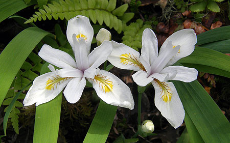
White Clackamas iris (Iris tenuis S. Watson)

Along this section of trail, the fire has been especially beneficial to the rare Iris tenuis S. Watson, or Clackamas iris. This elegant wildflower occurs in both blue and white in its very narrow range. It is found along the Clackamas and Molalla Rivers, and nowhere else. These iris form beautiful drifts of white blossoms along the burned section of trail in late May and early June.

White Clackamas iris (Iris tenuis S. Watson)

Ancient Forests

Beyond the fire zone, the trail dips into an impressive stand of ancient forest, tucked into a shady grotto between 200-foot cliffs and the Clackamas River, at the confluence with the Roaring River. These centuries-old western red cedar and Douglas fir thrive in the boggy river bottom, well protected from the elements.

In spring, the air in this pocket of ancient forest is filled with the pungent (and unmistakable) aroma of skunk cabbage growing in the bog, while the sound of falling water reveals a string of delicate waterfalls cascading over the cliffs, and into the green grotto.

Looking down at ancient forest from a cliff-top viewpoint

After passing through this magical spot, the Clackamas River Trail climbs a steep, rocky bluff above this hidden forest, providing a unique opportunity to observe the big trees from different levels, as if riding an elevator.

Hiking The Trail

Guidebook descriptions vary, but by my estimate, the hike from Fish Creek to beautiful Pup Creek Falls is about 8 miles round-trip, with the rollercoaster trail gaining about 900 feet in elevation along the way as it climbs around several cliffs. Because the high point at Pup Creek is only 1,300 feet in elevation, the trail is usually open year-round.

[Click here for a larger map]

The trail starts at the Fish Creek trailhead, located about 15 miles southeast of Estacada on Highway 224. The turnoff to Fish Creek is well marked, and is just past the Carter Bridge, Lockaby and Armstrong campgrounds.

Turn right onto Fish Creek road, pass the Fish Creek campground, cross the Clackamas on yet another bridge, then watch for the trailhead parking on the right, at the confluence of Fish Creek and the Clackamas. The trail begins at the far (south) end of the parking area, on the opposite side of the road, and is marked with a signpost.

The Fish Creek Trailhead

The path starts out wide and gentle, following a rustic dirt road to a small stream ford and dropping to the banks of the Clackamas. From here, the trail briefly rambles at river grade before entering the fire zone. Soon, the first uphill section begins as the trail climbs through the burn and over the first set of cliffs. On the bluff above the cliffs, white Clackamas iris line the trail in spring, along with many other wildflowers.

After the first crest, the trail descends to the river again, reaching a short pair of switchbacks just over a mile from the trailhead. Caution: watch for poison oak on both sides of the trail after the second switchback for a hundred yards or so — this is the only notable poison oak patch along the trail, but worth watching for (see map, above).

Section of the Clackamas River Trail

The trail follows the river bank only briefly, as the roller coaster trip through the burn section continues for another half-mile or so. Soon, the trail leaves the burn, and crosses the first in a series of small streams as it descends toward the ancient forest section, at about the 2-mile mark. There is a large riverside campsite among the giant cedars, here, and this makes a good spot to turn around if you are looking for a shorter hike.

Continuing through the ancient forest, the trail passes the skunk cabbage bog before crossing the largest of several streams dropping into the ancient forest grotto — and take a look upstream, too: a nearly hidden waterfall leaps off the cliffs beyond the big trees.

Next, the trail climbs a rocky bluff in a couple of switchbacks, providing that “elevator” view of the ancient forest, then a glimpse of the Roaring River confluence with the Clackamas, across the canyon. From here, the trail levels off, following the top of a bank of mossy cliffs for the next half-mile or so.

Steppingstone Creek

Soon, the trail crosses yet another lively creek, this one called “Steppingstone Creek” on the map for the helpful (and picturesque) series of stones that carry hikers across. From here, the final half-mile to the junction with the Pup Creek climbs very gently, with many river views.

The junction with the short spur to Pup Creek Falls is marked with a post, though no sign attached as of this spring. But you’ll know when you’re there: the junction is in a clearing under a transmission pylon. If you miss it, you’ll arrive at Pup Creek after 200 feet or so — by far the largest side stream on the hike, so you’ll know if you need to backtrack.

Upper Tier of Pup Creek Falls

The spur trail to the falls makes one quick switchback, but otherwise follows Pup Creek upstream to the dramatic amphitheater holding the 237-foot falls. In winter and early spring, the falls are particularly impressive, jetting a lot of spray to the small viewpoint at the end of the spur trail, so early season photographers should be prepared to battle the mist!

Because the falls are framed by a group of magnificent bigleaf maples, this is an ideal destination for late October or early November, when fall colors are peaking, and yellow maple leaves complement the bright yellow lichens on the walls of the amphitheater.

Traveler Tips

Highway Noise: on summer weekends, traffic on Highway 224 is more noticeable, so it’s a good idea to save this hike for mid-week, or the off-season for summer camping — or even winter, when you’ll have the place to yourself. That said, the highway proximity is rarely a distraction from the beautiful scenery on this trip.

“Leaves of three, let it be!”

Poison Oak: note the map, above — one enthusiastic patch of poison oak flanks both sides of the trail at the 1.2 mile mark, where the route descends through a short pair of switchbacks. The itchy stuff begins at the second switchback and continues for a couple hundred yards, but is easy to avoid if you know to watch for it.

Ticks: though rare, ticks have also been reported in the lower Clackamas canyon, so be sure to do a tick check after your trip — a good idea after any hike.

Camping: one of the handy aspects of this trail is the amazing selection of campgrounds in the vicinity — more than a dozen line the lower Clackamas. Two offer walking access to the trail: Fish Creek, near the trailhead described in this article, and Indian Henry, located about four miles beyond Pup Creek.

Forest Pass: the Fish Creek trailhead requires a Northwest Forest Pass, though this trailhead also has the option of a $5/day onsite payment for a day pass.

Brooks Meadow: Discovering a Hidden Gem

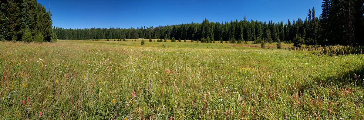
Brooks Meadow from the west

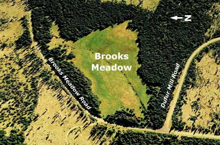
Brooks Meadow is one in a string of sunny meadows located on the gentle northern slopes of Lookout Mountain, just east of Mount Hood. At 35 acres, Brooks Meadow is among the largest, and has a long human history thanks to the water and forage it offers. It was likely visited for centuries by Native Americans, and in the late 1800s, was grazed with sheep following white settlement of the region.

(Click here for larger view of Brooks Meadow)

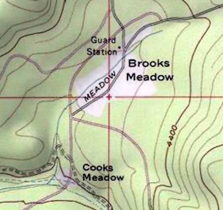
Early settlement trails in the area connected the dots between meadows and water sources, with several converging at the Brooks Meadow by the early 1900s. A guard station was constructed at the upper end at that time, near the junction of three trails at the north edge of the meadow. Later, the trails became primitive forest roads.

Brooks Meadow was surrounded by clearcuts by the 1980s

By the 1950s, sheep and cattle grazing in the Lookout Mountain area was on the decline, giving way to a boom in commercial logging. Timber harvests focused on the big ponderosa and larch stands unique to the east slopes, and mills in the area thrived. The timber boom hit its peak in the 1980s, when miles of logging roads and hundreds of clearcuts transformed the slopes of Lookout Mountain.

When the sawdust settled in the early 1990s, Brooks Meadow was somehow spared, a lush island in a forest that had been almost completely logged in all directions. By sheer luck, when the commercial logging boom swept the area, the old primitive road and trail system was mostly bypassed or destroyed by the modern, paved roads that carries logs to the mills.

A thin veil of trees were spared along the periphery of Brooks Meadow

At Brooks Meadow, a new paved route was built around the north side of the meadow (shown above), bypassing the historic dirt track through the center of the meadow. The Dufur Mill Road was also paved, and routed just south of the meadow, proper.

Thankfully, the relocated roads kept the steady stream of log trucks out of the meadow, and allowed the fragile ecosystem to survive the logging era relatively intact. In fact, the curtain of trees that was spared along the margins largely hides the meadow from today’s travelers, allowing Brooks Meadow to remain surprisingly unknown.

Old topographic maps still show the abandoned dirt roads and former Guard Station at Brooks Meadow

When the paved roads were built, the primitive roads through the meadow were simply abandoned, and never properly decommissioned. In the intervening years, these abandoned roads have begun to reforest, thanks to the drainage that keeps the old roadbed drier than the surrounding meadow, and survivable for trees.

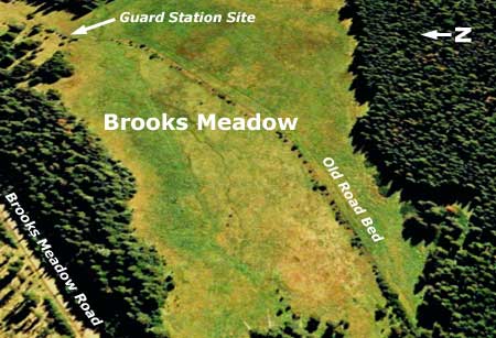
A closer view (below) of Brooks Meadow shows the abandoned road, and the dotted line of young trees that have begun to grow along the old roadbed. The location of the former guard station that once stood here is also shown.

The old road through Brooks Meadow is revealed by the young trees growing along it

Many of the meadows in the Mount Hood area are shrinking, thanks in part to a century of fire suppression and climate changes that allow for gradually encroaching forests. For Brooks Meadow, the threat comes from within, as well, with the strip of forest along the old road threatening to divide-and-conquer the meadow with reforestation.

This doesn’t have to happen, of course. The purpose of this article is to prod the U.S. Forest Service to consider a brushing project to remove the young trees along the old roadbed, and perhaps consider changes to the road’s drainage features that would help the old roadbed blend into the meadow, once again.

The brushing project is straightforward: there are about 60 young trees scattered along the old road, and they are small enough to removed by volunteers armed with bow saws and loppers. The drainage project would likely require more work, but could still be done by volunteers, assuming it is akin to trail maintenance work using hand tools.

Here is my offer to the U.S. Forest Service: I will assemble work crews of 10-12 volunteers for the brushing and drainage work needed to save Brooks Meadow. I believe the brushing could be done in a single day, and the drainage work in 2-3 volunteer days. Let’s get it done – we just need the green light from you!

Visiting Brooks Meadow

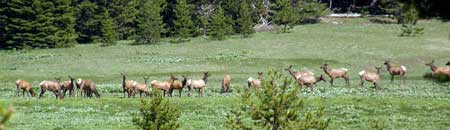
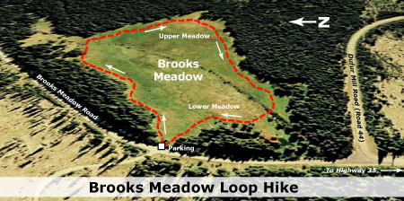
The best time to visit Brooks Meadow is in June and early July, when the wildflowers are at their best. In many spots, the flowers are waist-deep, and you will be surrounded by the sound of buzzing bees, singing birds and perhaps even spot elk or deer. There is no formal trail, but the going is easy if you follow the tree line along the edges of the meadow.

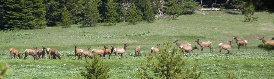
Elk grazing in the upper section of Brooks Meadow in 2009

(Click here for a larger view)

The route begins at the pullout “trailhead” at the west end of the meadow (see driving instructions, below). The best way to tour the meadow is clockwise from the pullout, following just inside the treeline. This will keep your feet fairly dry, and protect the most pristine inner portions of the meadow from human traffic.

In the clockwise loop around the meadow, you will be rewarded with mountain views from the upper end, and huge drifts of wildflowers in early summer. Autumn is also a beautiful time to visit the meadow, though you should wear hunters colors whenever hiking on the east side in fall. In morning and evening, there are often elk and deer browsing in the meadow. Be forewarned not to approach elk herds — simply enjoy them from a distance.

(Click here for a larger map)

One uncommon plant to look for in the meadow is Agoseris elata, or tall agoseris. This plant is in the sunflower family, and looks a bit like a dandelion blossom on steroids. Agoseris elata grows in just two places in the entire Mount Hood National Forest — Brooks Meadow and nearby Bottle Prairie.

How to Get There

Brooks Meadow is located just off Forest Road 44, east of Mount Hood. Follow Oregon 35 from either Hood River or US 26 to the Forest Road 44 junction. Turn east, and follow Road 44 uphilll for several miles to the obvious intersection with Forest Road 17, where Forest Road 44 abruptly turns right. Continue straight at this intersection, onto Road 17, and immediately watch for a pullout just 100 yards from the intersection.

(There are no restrooms or water sources at this informal trailhead. The nearest facilities are at the Sherwood campground, located along Highway 35, north of the Road 44 junction)

Postscript

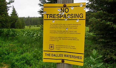
After publishing this article, I noticed that the Forest Service and City of The Dalles have been busy posting the boundaries of The Dalles Water Watershed, again, including the informal trailhead at Brooks Meadow.

At least the shooters appreciate the new targets posted at Brooks Meadow

It’s a bit hard to take the closure seriously (most don’t, actually), given how the agencies have carved up this once pristine area with miles of logging roads and hundreds of clearcuts. More absurd is the fact that the “protected” stream flowing from the meadow is soon piped under paved Brooks Meadow Road in an open culvert — apparently, an area where protection isn’t required. Beer cans tossed in the culvert from passing pickup trucks complete this ironic picture.

So, use your judgment in visiting Brooks Meadow. While it’s hard to believe that hikers visiting the meadow to appreciate its beauty would actually be prosecuted (and spend the advertised six months in jail and a $500 fine, no less!) the posted closure is for real, unfortunately.

The Hidden Shame of Latourell

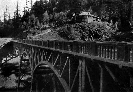
Since tourists first began exploring Samuel Lancaster’s graceful new Columbia River Highway in 1915, Latourell Falls has been a favorite stop. In the early days, a pair of roadhouses (the Falls Chalet and the Falls Villa) flanked the highway at the east end of the dramatic highway bridge spanning the creek, and offered lunch with a view of the falls.

Today, the falls are the main focus of Guy Talbot State Park, with thousands of visitors each year exploring the series of loop trails that circle the lower falls and follow Latourell Creek to the upper falls.

The Falls Chalet in 1915

The scenes along Latourell Creek are beautiful and iconic, and most visitors simply accept that this place will be protected forever for the public. Yet, experienced hikers notice something different about this western-most of the waterfall trails in the Columbia Gorge: it’s not pristine, at least not in the way that other streams in the Gorge are. Despite the beautiful setting, big trees, wildflowers and waterfalls, something about this stream seems degraded.

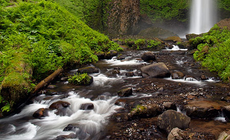
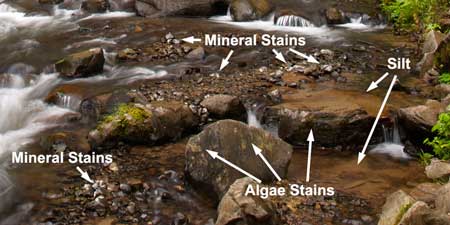
When crossing the rustic footbridge at the thundering base of Latourell Falls, there is often a distinct odor of algae in the air. A closer look at the stream reveals not only algae on the rocks, but also crusty mineral deposits that also suggest degraded water quality in this beautiful stream, and would help explain the algae blooms.

This close-up view (below) is a detailed look at the lower right corner of the previous image of Latourell Falls. The close-up view reveals white mineral deposits and yellow-grown algae stains on several boulders and cobbles. This view also shows fine silt deposits (brown areas in the lower right) that suggest some sort of major disturbance in the watershed.

Why is this? What’s behind the water quality problems on this otherwise untouched stream?

Going to the Source

Upstream from the waterfalls and throngs of visitors along the lower canyon section of Latourell Creek, an explanation for the degraded water quality is revealed. Though few visitors to the lower reaches of the stream would imagine it, the headwaters of Latourell Creek are privately owned, with a number of homes and a lot of logging along the stream.

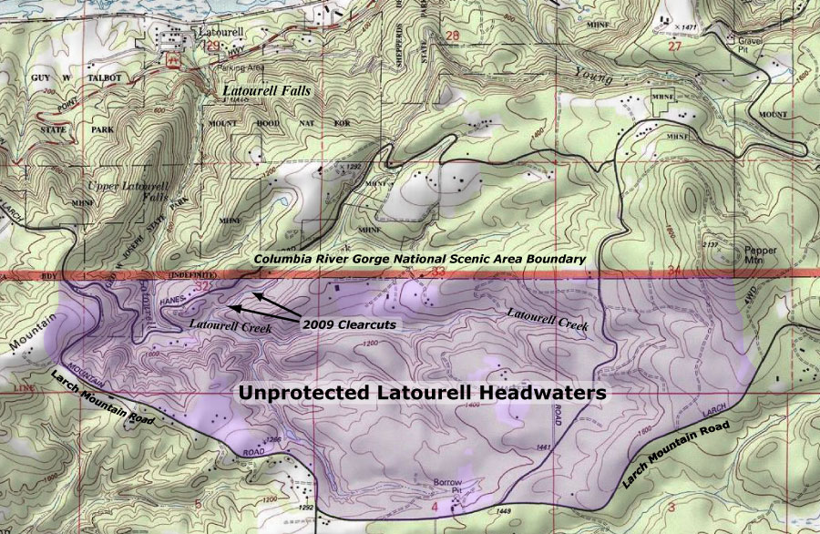
Amazingly, more than three quarters of the Latourell Creek watershed lies outside the protection of public parks and the Columbia River Gorge National Scenic Area (CRGNSA).

While the private homes are partly responsible for the nutrients that feed algae and leave mineral deposits in Latourell Creek (from lawn chemicals, septic tanks and other sources), the aggressive logging of private lands in the upper watershed is the greatest risk to stream quality.

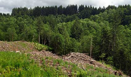
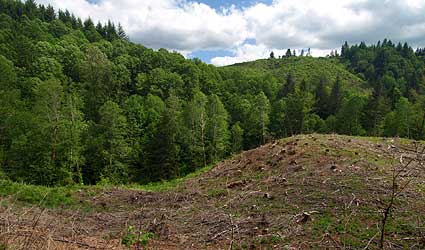
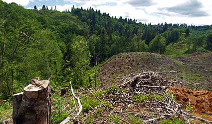
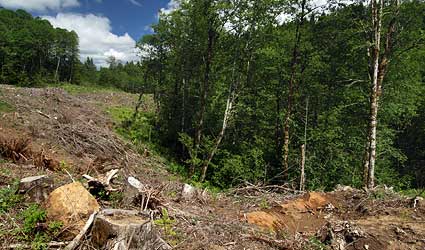
The environmental impact of logging in the headwaters is painfully obvious, with canyon slopes recklessly harvested in clearcuts. This is a discredited, outmoded form of timber management that shouldn’t be practiced anywhere, much less a stream of this caliber that flows into a National Scenic Area.

The clearcut photos shown here were taken in the summer of 2010, with most of these harvests just a couple of years old. In this view (below), an older clear cut can also be seen on the hillside across the canyon, and is just beginning to recover with a light green layer of growth. Most of these forests have been cut several times, with ever-shortened growth cycles between harvests, thanks to a growing market value for marginal timber.

In this view (below) raw skid roads in the lower right drain directly into Latourell Creek, which flows along the tree line, at the edge of the clearcut. Erosion from bare slopes and logging roads is responsible for the most fine sediments (mud) seen below, in the protected sections of Latourell Creek. These sediments not only spoil the stream bottom, they also introduce minerals at a rate which promotes the growth of algae, which in turn, can also harm stream health.

Sadly, Oregon law continues to allow timber harvesting using the clearcut method, and the few environmental protections that do exist for stream protection on private timberlands are little compensation for the effects of clear cutting.

The tragic reality is that in Oregon, the timber lobby is still king. Twenty years of non-stop public relations advertising (kicked off during the early 90s Spotted Owl crisis) by Big Timber have been surprisingly effective in keeping the public largely misinformed on what is really happening in private forests.

In this view (below) of upper Latourell Creek, the private property owner has left the minimal amount of riparian “buffer” required by Oregon law. The trees in this photo are less than ten feet from the edge of Latourell Creek, and most of what you see is actually growing on the opposite bank from the clearcut. Clearly, this practice threatens severe erosion and sediments from the logged area entering the stream in a region where rainfall amounts can reach 100 inches annually.

Clearcuts threaten more than steams and water quality, however. In the 1990s, the Oregon timber lobby was forced to accept limits on clearcutting above roads and dwellings because of a number of catastrophic slides that had been triggered around the state by the practice.

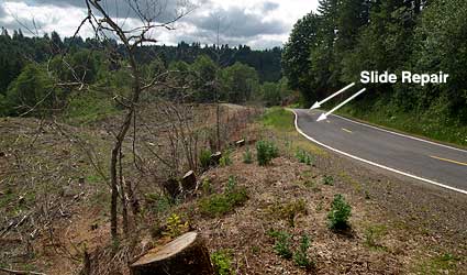
Yet, few limits on logging below developed roads exist, and in the case of the upper Latourell canyon clearcuts, the impact of logging on the slopes below the local roadways is real. In the following view, large trees have not only been recklessly cut from the slope below the road, but the remaining smaller trees and shrubs have been sprayed with herbicide — a routine treatment after clearcutting — and thus killing what was left of root systems that help hold the slope together. As the image indicates, there are already active slides along this slope, triggering road repair costs that will fall upon the public to fix, not the private land owner.

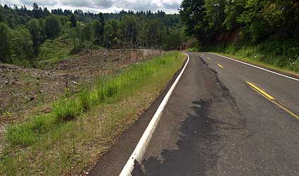
This photo (below) shows the slide repair in more detail — a 200-foot section of road that has already been filled and patched repeatedly, and now will likely continue to fail thanks to a slope that has been further destabilized by aggressive logging.

What’s the Solution?

For much of Oregon, the fate of clearcutting is an open question, with the timber lobby thus far successful in its efforts to prevent the practice from being outlawed. That’s a shame, and a sad commentary on our state politics. But in the case of Latourell Creek, there’s another option.

When the authors of the Columbia River National Scenic Area (CRNSA) were drawing up maps, they focused on scenery and what could be seen from points along the Columbia River. As a result, the scenic act ignored a crucial lesson learned from the newer national parks of the 1960s — most notoriously, Redwoods National Park — that when acquiring park lands, complete ecosystems and watersheds should define the boundaries.
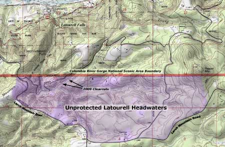
A look at the CRNSA boundary in the Latourell Creek headwaters shows the problem: the upper watershed falls outside the scenic area, and thus is excluded as a place for meaningful regulation or public land acquisition.

Click here for a larger map

It doesn’t have to be this way, however. These lands should be added to the CRNSA, and managed holistically, with the health of the spectacular lower canyon in mind.

After all, Latourell Creek is the only major stream on the Oregon side of the Gorge to straddle the boundary, and thus a good case can be made for amending the CRNSA boundary to incorporate the complete watershed. This would allow for better regulation of private lands in the headwaters, at a minimum, and also allow for CRNSA land acquisition funds to be used here.

Upper Latourell Falls

Another argument in favor of expanding the CRNSA boundary is the convenience of Larch Mountain Road in defining the Latourell Creek watershed. This popular recreation route is already viewed as “part” of the scenic area, albeit outside the boundary in this section. Therefore, an expanded boundary would allow the full Larch Mountain Road corridor to be managed as an extension of the scenic area. This extent is reflected on the map, above.

What Would it Take?

Amending the CRNSA requires an act of Congress, and though it sounds daunting, minor changes to federal boundaries of this sort are common as “riders” on larger federal lands bills.

While better regulation of private lands in the upper Latourell watershed would surely come from an expanded CRNSA, the chief benefit would be the ability to acquire lands for restoration. Already, the Forest Service has acquired hundreds of acres of private elsewhere in the Gorge, and the upper reaches of Latourell Creek would be best protected by fully restoring the watershed.

Upper Latourell Falls

Yet another option could be for advocacy organizations — like the Friends of the Columbia Gorge or Trust for Public Lands — to acquire the upper watershed lands. However, these groups generally operate inside the existing CRNSA boundary, and focus limited funds on still-pristine lands or those with exceptional scenic value.

In the end, it seems that our best bet is for the Oregon Congressional delegation to consider a “housekeeping” update to the CRNSA, including boundary refinements. Perhaps a 20-year review of the CRNSA is in order in 2016?

Discovering Bald Mountain

The country is filled with “Bald Mountains”, but for sheer scenic spectacle, few can compare to the Bald Mountain that rises just four miles away from the towering west face of Mount Hood. At one time, a fire lookout stood atop this Bald Mountain, and the view from the tower must have been the envy of fire lookouts around the Northwest.

Today, Bald Mountain isn’t entirely bald, having grown a dense forest of noble fir along the crest and northern slopes over the past half-century. Yet, it was in the 1970s, when the Timberline Trail was rerouted to lead hikers across the steep, open meadows on the south slope of the mountain, that hikers became familiar with Bald Mountain. Today, this spectacular traverse continues to provide one of the most popular, exhilarating sections along the classic loop hike.

Though most visitors to Bald Mountain keep to the Timberline Trail, you can still follow the historic old path that leads to the former lookout site, with its magnificent, close-up views of Mount Hood. Thanks to the quiet efforts of a few anonymous volunteers over the decades, the trail remains open and lightly maintained, with only an occasional log to step over along the way.

As the old path climbs toward the summit, hikers find themselves in a dense, young forest, and have to use their imagination to picture the open slopes of beargrass — with no forests — that existed when the first lookout was built on “Bald” Mountain more than a century ago.

Along the old trail, hikers will also spot blazes on the few trees that stood at the time of the former lookout tower. These blazes mark most historic trails (see this recent article on blazes) in the Mount Hood area, and confirm that the present alignment of the summit path to Bald Mountain dates back to at least the World War II era, and likely before.

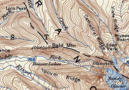
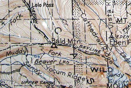
A look at the 1911 USGS map of Mount Hood (below) shows that a “lookout” stood on Bald Mountain long before roads crossed Lolo Pass, and decades before the Timberline Trail was built. The early lookout structure was likely no more than a wood platform, later replaced with a conventional lookout tower. Interestingly, the Beaver Lakes shown on the map have since faded away, too, filled in with forest:

The 1946 USGS map of the Mount Hood area (below) is the last to show a lookout on Bald Mountain (and the Beaver Lakes), but in the intervening years from the 1911 map, the Timberline Trail and Skyline Trail had been completed, with both routes passing just below the lookout.

In fact, it’s likely that the section of Skyline Trail from Lolo Pass to Bald Mountain was originally built for lookout access, since the trail over Lolo Pass was among the earliest built in the area, and in fact, followed an ancient Indian route connecting the Sandy and Hood River valleys.

The alternating ticks shown along the dashed trail segments on the 1946 map indicate a telephone line along the route. Today, these routes often have ceramic insulators still attached to trees, and on this route further suggest that this section of trail was originally built with the lookout in mind. The route is now part of the Pacific Crest Trail, which replaced the old Skyline Trail, and remains one of the best approaches for hiking to Bald Mountain.

What did the old tower look like?

Fire lookouts in the Pacific Northwest followed a few standard designs beginning in the 1930s, after much improvisation in the early lookout designs that were built through the 1920s. The Bald Mountain lookout probably followed this evolution, with some sort of simple platform beginning at the turn of the twentieth century, and later, a more substantial structure built to Forest Service standards.

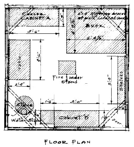
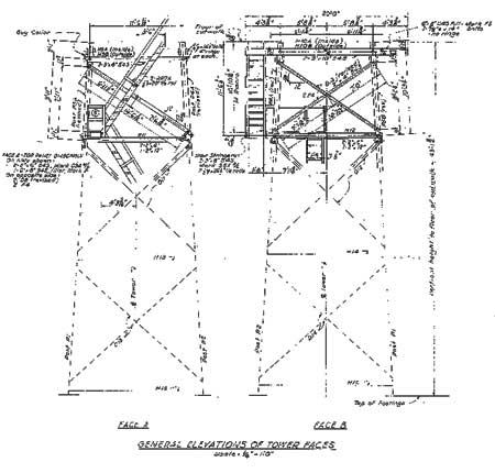
We have a much more exact picture after June 1944, when archived Forest Service documents show a new lookout was designed, apparently to replace an existing structure on Bald Mountain. The following are samples from the 1944 architectural plans for Bald Mountain. There are no clear records of when this lookout was removed, but it was likely in the late 1950s or 1960s, when hundreds of lookouts were viewed as outmoded by the Forest Service and destroyed.

The cab — or cabin — in the 1944 designs for Bald Mountain is a 14×14 foot structure (above) that would closely resemble the surviving cab on the Devils Peak lookout, just to the southwest of Mount Hood in the Salmon-Huckleberry Wilderness. This simple design featured five windows per side and a low, pitched roof.

Inside the cab (below), the living space was organized around a Osborne fire finder, located in the center of the floor, surrounded by a wood stove, table, kitchen, storage cabinets, shelves and bunk. A catwalk wrapped around the outside of the cab, allowing lookouts to maintain the windows, raise and lower shutters and haul firewood and supplies up from below with pulleys.

The 14×14 foot cab rested atop a 43-foot wood-frame tower (below), complete with a spiraling stairway that ascended within the tower uprights. Though the tower was anchored directly to the ground, the main stabilization came from guy wires anchoring the tower to concrete footings in four directions.

The most remarkable aspect of this tower (and many others) is the fact that most of the materials were carried to the site over trails using livestock. That included the cut lumber, concrete, construction hardware, fixtures and windows — an amazing feat when you consider this was repeated dozens of times at lookout sites around the region.

The lookout plans for Bald Mountain also contain one “standard” element that wasn’t so standard, at least compared to other lookouts in the vicinity: a garage and storage shed built around the base of the tower. In this view, the stairway to the tower can be seen on the right, with the dashed lines above the garage marking the location of the tower uprights:

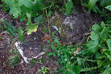
As this design detail from the 1944 plans suggests, there were a number of concrete footings used in the construction of the Bald Mountain lookout tower. Today, these seem to be the only remaining traces of the structure. Three footings are loose, and have been moved around and used by campers over the years. Other footings remain in the ground, mostly reclaimed by the undergrowth. This footing is located along the spur trail leading to the east viewpoint from the lookout site:

Visiting Bald Mountain

There is some irony in the historic Bald Mountain trail being “lost”, as the mountain is now almost completely circled by the Timberline Trail, and thousands of hikers make their way along this route every year. Almost all of these visitors walk right past the unmarked summit path leading to Bald Mountain.

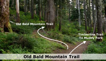
But for those seeking the route less traveled, the hike to the summit is easy, provided you successfully navigate the maze of popular trails in the area. The key is knowing how to spot the unmarked junction with the Timberline Trail. Take a close look at this photo to help you recognize the spot if you choose to visit the old trail — this view is how the trail appears from either of the approaches described below:

From Lolo Pass: The Classic Approach

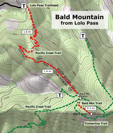
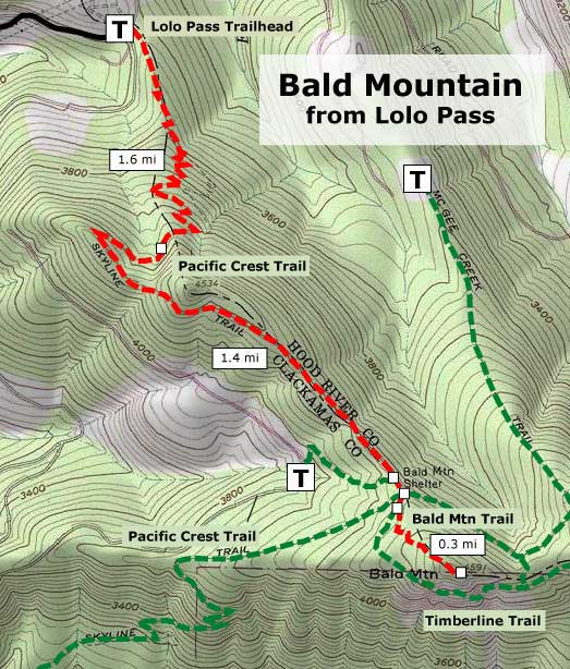
The classic hike begins at Lolo Pass, and follows the Pacific Crest Trail through handsome forests for three miles to the base of the Bald Mountain summit path. The total mileage on this option is 6.6 miles round trip, with an elevation gain of 1,400 feet. The following is a map of the Lolo Pass approach that accompanies the hike description I wrote for the Portland Hikers Field Guide:

Click here for a larger map

For a detailed description of the Lolo Pass approach, visit the Portland Hikers Field Guide page:

Lolo Pass to Bald Mountain Hike

The Field Guide description also includes driving instructions to the trailhead. This is a dry hike, so carry water — and in early summer, plan on the usual bugs that plaque hikers just after snow melt. My favorite time to hike this trail is on a clear day after the first autumn snow dusts the mountain in late September or October. This is when the area is free of bugs AND crowds.

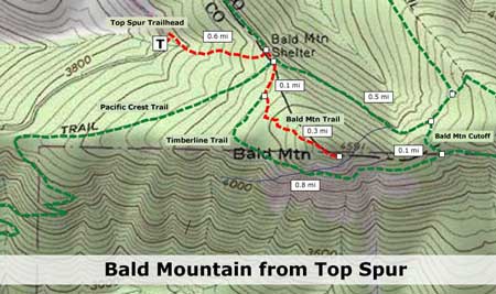
From Top Spur: The Family Route

For a shorter hike that works well for families with kids (or for adults looking for a short afternoon or evening activity) you can also approach Bald Mountain from the Top Spur trailhead. Be forewarned that this is one of the most popular trailheads in the Mount Hood region, and mobbed on summer weekends.

But even on busy weekends, you can smile to yourself as you leave the crowds behind, and head up the quiet, old lookout path for some solitude — hidden in plain sight! From the summit viewpoint, you can literally look down on hikers passing hundreds of feet below on the Timberline Trail, oblivious to your presence.

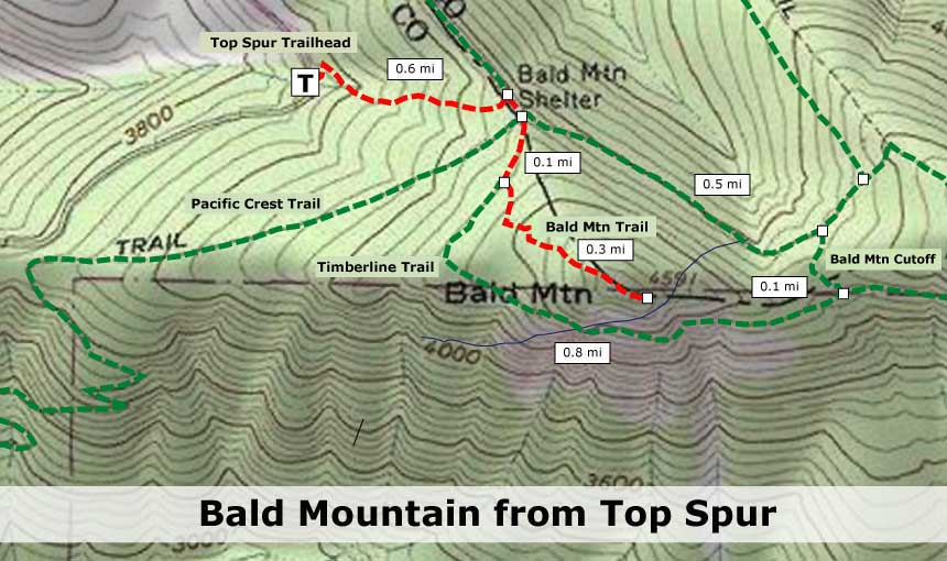
Click here for a larger map

The Top Spur option is just two miles long, round-trip, with an elevation gain of 550 feet. Though short, portions of both the Top Spur and Bald Mountain trails are steep, so you will notice the elevation gain! The tradeoff for kids is the feeling of climbing a real mountain. Bring a pair of binoculars for kids to explore the details of Mount Hood or watch hawks float across the Muddy Fork Valley, below.

For a detailed description of the Top Spur approach, including travel instructions, visit the Portland Hikers Field Guide page:

Top Spur to Bald Mountain Hike

One of the most magical times to visit Bald Mountain is evening, when you can watch the awesome west face of Mount Hood light up at sunset, but still have enough light to hike back to the Top Spur trailhead.

Both hikes are usually open from mid-June through mid-November, and both require a Northwest Forest Pass to park. Both trailheads usually have portable toilets, but no water — be sure to carry your own.

Close Call at White River Falls

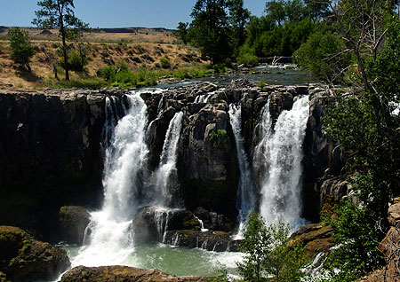
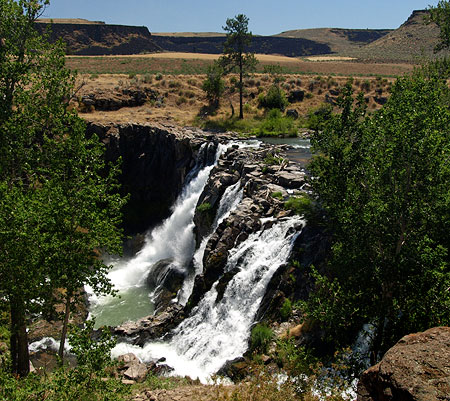
The magnificent desert falls on the White River survived a close brush with disaster this month, when a throwback proposal by Wasco County to divert the river as part of a new hydropower project was scrapped.

Like so many hydro projects of decades passed, this one would have had “little impact”, according to proponents. Yet, as we take in the summertime view of the 90-foot plunge pictured above, it’s obvious that diverting the river would have an immediate impact on the natural beauty of the area. Would half the falls be diverted? Two-thirds? All of it?

(click here for a PDF of Dalles Chronicle article)

Though the Wasco County proposal was ultimately dropped because of concerns voiced by the Oregon State Parks Commission, it wasn’t for lack of “goodies” offered up in exchange for the diversion. The County promised trail improvements for recreation, and interpretive facilities for the structures left behind from the last hydro project here.

White River Falls with the rocky gulch of Devils Halfacre in the background

The old plant was shut down in 1960, and the land subsequently transferred to the state, first as the “Tygh Valley State Wayside”, then today’s “White River Falls State Park.”

The falls and adjacent White River Gorge are truly a forgotten gem in Oregon, save for a few fishermen in spring and fall, and a lot of teenagers in summer, seeking out the swimming holes below the falls. Yet, the area is only two hours from Portland, and offers some of the most accessible desert scenery in the state.

In recent years, hikers have begun to explore the area, following boot paths and game trails downstream toward the confluence with the Deschutes River, just over two miles below the falls.

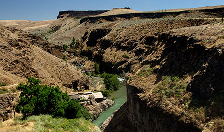
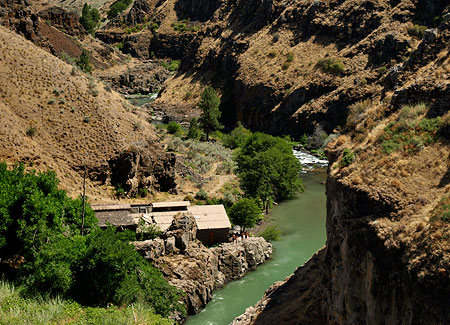
White River Gorge from the falls overlook

What most visitors don’t know is that much of the rugged backdrop for the falls is private land. Most surprisingly, these private holdings include the most of the White River gorge, all the way to the Deschutes confluence, and this beautiful area has somehow escaped development over the years.

Concept: White River Gorge Recreation Area

With Wasco County politicians dreaming up hydro projects for the White River, this article is intended as a more forward-looking counterpoint that actually embraces the scenic and recreational values in the area.

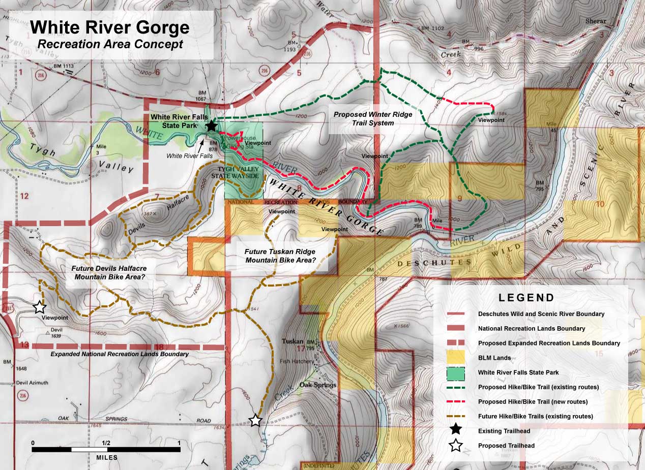
As a starting point, the National Recreation Lands boundary that encompasses the larger Deschutes Canyon could be expanded to include White River Falls, White River Gorge and the adjacent Winter Ridge and Devils Halfacre areas. This could provide the direction needed for state and federal land agencies to begin acquiring private land and planning for recreation.

It’s unclear what the “National Recreation Lands” boundary actually means, however. It seems to mirror the Wild and Scenic River designation for the Deschutes Canyon on USGS maps, but may be an orphan from old federal plans and policies no longer in force. Current federal planning documents for the lower Deschutes Canyon are also badly out of date, so a better legal mechanism likely exists for recognizing the potential for recreation in the White River Gorge area. In the end, some sort of designation is needed to identify the extent of the new recreation area.

The following map outlines the concept, with the proposed new White River Gorge recreation area bounded in dashed red, existing White River Falls State park in green and federal land holdings (BLM) in yellow:

(Click here for a much larger, more readable map)

The proposal: a network of new desert trails

The main focus of the concept is to build new trails in the White River Gorge, proper, and on the adjacent highlands that I’ve called Winter Ridge for the purpose of this article. The gorge is mostly private land outside the present state park boundaries, so like all of the trail proposals called for in this article, a new White River Gorge trail implies public ownership or easement.

The dashed red lines on the map show the new trail extending through the canyon from the falls to the confluence with the Deschutes, along with a short viewpoint loop within the current state park boundaries. This would become a premier hiking trail in the region, providing a unique riverside hiking experience in a roadless desert canyon.

The first portion of this new trail would simply follow the existing route down to the old power plant, with a new loop climbing back to the trailhead, via a canyon viewpoint above the falls. This part of the proposal could be built now, as it falls entirely within the current state park boundary.
Remains from the former power station in White River Gorge

The canyon trail would offer a unique interpretive opportunity where relics of the old power plant still exist. The Wasco County hydro proposal recognized the historic importance of these structures, and called for interpretive improvements along this existing trail, at the penstock and in the old power plant. These historic structures have been badly vandalized over time, and could greatly benefit from some modest renovation and protection.

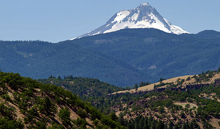
In addition to the White River Gorge trail, the proposal calls for a network of hike and bike trails over the broad slopes of Winter Ridge. This area rises steeply above the confluence of the Deschutes and White rivers, with views nearly 800 feet down into the gorge from the open crest. The west slopes drop gently to the trailhead at White River Falls, with sweeping views of Devils Halfacre, Tygh Ridge, Mount Hood and Mount Jefferson.

The proposed trails shown on Winter Ridge (in green on the map) are almost entirely along existing paths and roads, and would require little beyond signage to improve them for hikers and mountain bikers.

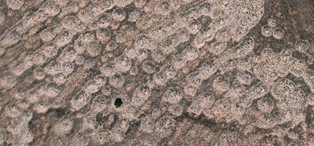
Desert mounds along Winter Ridge (the black dot is a juniper tree, for scale)

Though a portion of Winter Ridge is farmed with winter wheat, much of the terrain is in a native state. The upper slopes of the ridge feature an odd landform unique to the Lower Deschutes River country: countless mounds of soil and rock, often organized in rows. They span 10-20 feet in width, and stand a few feet in height.

These odd “desert mounds” appear on shallow slopes and hilltops throughout the Tygh Ridge area, and this would be one of the few areas where visitors could examine these mysterious formations, up close, and learn some of the many theories about their origin.

Thinking Big: an expansive trail network at Devils Halfacre

It is impossible to stand at White River Falls and not notice the rugged, picturesque rim rock cliffs and massive bluffs that rise to the south of the White River Gorge. This rocky maze is the Devils Halfacre, and though in private holdings now, it offers an especially interesting potential for recreation.

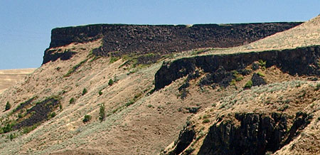
Black basalt cliffs and talus slopes of Tuskan Ridge rise above the White River Gorge

The area falls into two general units: the rocky gulch of Devils Halfacre, proper, and the huge mesa forming the east wall of the gulch, which I’ve called Tuskan Ridge for the purpose of this proposal (see map). A network of trails and dirt tracks already exists here, and could easily be adapted to become an exceptional hike and bike trail network. These trails would lead hikers, bikers or possibly equestrians past rugged rock formations to spectacular, cliff-top viewpoints.

The Devils Halfacre area has excellent potential for trailhead access from both Highway 216 and Oak Springs Road. The terrain here rivals popular destinations in the eastern Columbia River Gorge, and would offer a unique chance to bring sustainable recreation tourism to the local economy.

Looking Forward

The concept presented here is just one way in which recreation and landscape restoration could be combined to preserve the White River Gorge area.

The intense demand for mountain biking opportunities also offers the potential to transform the local economy, especially since the area is just far enough from the Portland metropolitan area to draw overnight and weekend visitors who could support local businesses.

Mount Hood, rising across Tygh Valley from Winter Ridge

At a minimum, now is the time for Wasco County to aim for a more sustainable vision for White River Falls and its surroundings, instead of rehashing old, exploitive ideas that would degrade the area, and that have already failed here, before.

The Oregon State Parks Commission was right to challenge the County’s attempt to turn back the clock at White River Falls. Now would be the perfect time for the County to partner with the Parks Commission and federal agencies to forge a new vision that does justice to the remarkable landscape that exists here.

Return of the Mountain Goat

Rocky Mountain Goats by Albert Bierstadt

Along their return trip across the continent, on April 10, 1806, the Lewis and Clark expedition visited a small Indian village on what is now Bradford Island, in the heart of the Columbia River Gorge. Here, they traded for a beautiful white hide from what we now know as a Rocky Mountain Goat. Meriwether Lewis described it unmistakably in his journal as a “sheep”, white in color with black, pointed horns. The Bradford Island villagers told the expedition the hide had come from goat herds on the high cliffs to the south of what is now Bonneville, on the Oregon side.

Two days later, the expedition encountered another group of Indians, this time near present-day Skamania, on the Washington side of the river. A young Indian woman in the group was dressed in another stunning white hide, and this group also told of “great numbers of these animals” found in “large flocks among the steep rocks” on the Oregon side.

Rocky Mountain Goats by John Woodhouse Audubon

A century later, New York attorney Madison Grant produced the first comprehensive study of the Rocky Mountain Goat for the New York Zoological Society, in 1905. Grant described the historical range of the species extending from British Columbia south along the Cascade Crest to Mount Jefferson. At the time of his research, he reported that mountain goats had “long since vanished from Mt. Hood and from other peaks in the western part of the State, where they once abounded”.

Coincidentally, Grant’s report was published just a few years after the Mazamas mountaineering club formed on the summit of Mount Hood, selecting the Rocky Mountain Goat as their namesake and mascot — apparently, decades after the species had been hunted out in the Mount Hood region.

Early 1900s linen postcard from Glacier National Park

Another century later, on July 27, 2010, the Oregon Department of Fish and Wildlife (ODFW) and Confederated Tribes of Warm Springs made history by releasing 45 Rocky Mountain Goats in the remote backcountry of Whitewater Canyon, on the east slopes of Mount Jefferson, just inside the Warm Springs Reservation.

The Mt. Jefferson release marked a symbolic and spiritual milestone for both conservationists and the Warm Springs Tribe, alike, restoring goats to their native range after nearly two centuries. The release also marked the first step in a major goat reintroduction effort, as envisioned in the landmark 2003 plan developed by ODFW to return goats to their former ranges throughout Oregon.

2010 release near Mt. Jefferson (Photo by Jim Yuskavitch/ODFW)

When the 2003 ODFW plan was developed, about 400 goats were established in the Wallowa and Elkhorn ranges, a few dozen in Hells Canyon, and a few scattered goats had dispersed just beyond these concentrations. The plan calls for moving goats from these established populations to historic ranges in the Oregon Cascades, including in the Columbia River Gorge. The proposed Gorge introduction sites include the rugged Herman Creek headwaters, the open slopes and ridges surrounding Tanner Butte and the sheer gorge face below Nesmith Point. The plan also calls for reintroducing goats at Three Fingered Jack and the Three Sisters in the Central Oregon Cascades.
Members of the Confederated Tribes holding goat kids at 2010 release (Photo by Jim Yuskavitch/ODFW)

The new effort to bring goats back to the Oregon Cascades is not without controversy. Conservation groups have taken the U.S. Forest Service and ODFW to court over lack of adequate environmental review of the plan to bring goats to the Gorge, and the agencies are now completing this work. The legal actions that have slowed the Gorge reintroductions helped move the Warm Springs effort forward, and are likely to move sites near Three Fingered Jack and the Three Sisters ahead of the Gorge, as well.

The 2003 reintroduction plan is also based on selling raffle-based hunting tags that fund the reintroduction program. This strategy is surprising to some, given the small number of animals surviving in Oregon. However, with the raffle for a single tag in 2010 raising nearly $25,000 for the program, it’s clear that selling hunting rights will help guarantee funding the reintroduction effort at a time when state budgets are especially tight.

Mountain Goats on Mount Hood?

The renewed interest in bringing mountain goats back to the Cascades, and the notable omission of Mount Hood from the ODFW plan as a release site, raises an obvious question: why not? The plan doesn’t provide details, but the likely arguments are lack of available habitat and the overwhelming presence of humans on Mount Hood.

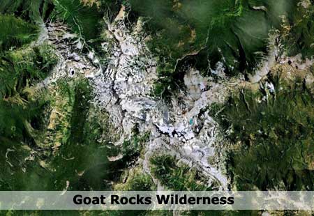
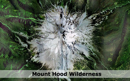
The ODFW plan prioritizes sites that can support at least 50 goats, including space for adult males to roam separately from herds of females and juveniles. Without knowing a specific acreage requirement for individual animals, the following comparison of Mount Hood to the Goat Rocks area helps provide perspective — with an estimated 300 mountain goats thriving at Goat Rocks. These images are at identical scale, showing comparative amounts of alpine terrain:
The Goat Rocks (above) clearly has more prime habitat terrain at the margins of timberline, thanks to the maze of ridges that make up the range. But in total alpine area, the Goat Rocks are not much larger than Mount Hood (below), so it appears that Mount Hood has the space and habitat for at least 50 goats.

The human presence at Mount Hood is a more compelling argument against reintroducing goats. The south side of the mountain is busy year-round, thanks to three ski resorts, with lifts reaching high above timberline into what would otherwise be prime goat habitat. Snowshoers and Nordic skiers fill the less developed areas along the loop highway, making the south side one of the busiest winter sports areas in the region.

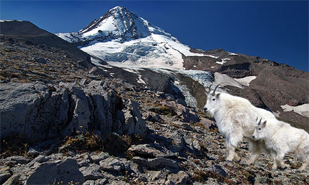
However, on the east, north and west sides of the mountain, human presence is mostly seasonal, limited to hikers in summer and fall along the Timberline Trail. These faces of the mountain have also been spared from development by the Mount Hood Wilderness, and thus offer long-term protection as relatively undisturbed habitat. This view of the mountain from the north gives a good sense of the many rugged alpine canyons and ridges that are rarely visited, and could offer high-quality goat habitat:

Since we know goats once thrived on Mount Hood, and adequate habitat seems to exist for goats to survive today, the real hurdle might simply be perception — that wildlife managers cannot imagine wild goats coexisting with the human presence that exists on some parts of the mountain. If so, we may miss a valuable opportunity to reintroduce goats where a large number visitors could view and appreciate these animals.

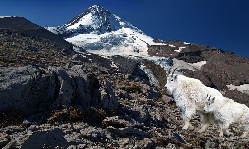
To help remedy this apparent blind spot, the following are a couple of digital renderings of what once was — and perhaps would could be — on Mount Hood. The first view is from Gnarl Ridge, on the east side of the mountain. Here, goats would find plenty of habitat in the high ramparts bordering the Newton Clark Glacier. This area is among the most remote on Mount Hood, so ideal for goats seeking a little privacy from human visitors:

The most obvious Mount Hood habitat is on the north side, on the remote, rocky slopes that border the Eliot, Coe and Ladd glaciers. This part of the mountain is only lightly visited above the Timberline Trail, and rarely visited in winter. It’s easy to picture goats making a home here, on the slopes of Cooper Spur:

(click here for a larger view)

Wildlife managers probably have good reason for skepticism about bringing goats back to Mount Hood. After all, the risks are clearly greater here than at less developed sites.

But let’s reverse these arguments: what if mountain goats were viewed as an end goal in restoring Mount Hood? What if this challenge were reframed as “what would it take for mountain goats to thrive here?” What if successful restoration of Mount Hood’s ecosystems were simply defined by the ability to support an iconic native species like the mountain goat, once again?
________________________

To read an Oregonian article (PDF) on the 2010 Mt. Jefferson goat release, click here.

Warren Falls Lives! (temporarily, at least)

Warren Falls flowed briefly in early December

As an update to this recent article on restoring Warren Falls, I made a trip to the site of the former falls during a classic “pineapple express” pattern of winter monsoons earlier this month. I was thrilled to find a small amount of Warren Creek cresting the weir that has diverted the creek into a bypass tunnel for the past 75 years, and pouring over the falls.

It was remarkable to be in the amphitheater with water cascading over the escarpment, once again, and even if only temporarily. The small amount making its way over the brink completely changed the place from an eerie, somber cavern to a bright, sparkling glen. It was even more exciting to imagine the full force of Warren Creek plunging over the high cliffs, given the thundering display at Hole-in-the-Wall Falls (which is created by the bypass tunnel).

Here is a short video from that day that captures the scene and tells the story of Warren Falls:

Sunshine Rock

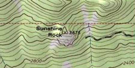
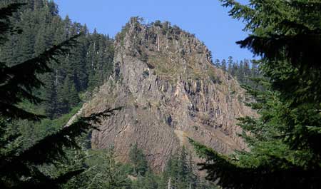
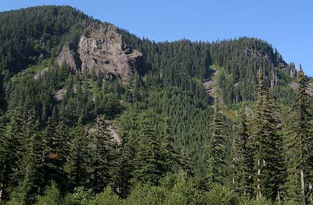
Located in a deep canyon near Lost Lake, Sunshine Rock is a 700-foot monolith that would rival famous Beacon Rock in the Columbia Gorge, were you to set them side-by-side. The two rocks might even look a bit like twins: both feature walls of distinctive columnar basalt, and rise to a broad, fluted crest.

Despite its impressive size, Sunshine Rock is nearly hidden from view in the Lake Branch canyon, a few miles upstream from the West Fork Hood River. The rock briefly comes into view traveling down Lake Branch Road from Lost Lake, but only for a moment. With a little exploration, though, better views of this massive rock can be had from less-traveled routes in the area.

Sunshine Rock from Lake Branch Road

Sunshine Rock is a classic basalt plug — the solidified lava throat of an ancient volcano that was once a mountain. Geologic maps of the area identify the rock as andesitic basalt, dating back to the Miocene period of more than 7 million years ago.

This means that Sunshine Rock was formed as part of the “Old Cascades”, the range or deeply eroded peaks and ridges that pre-date today’s relatively young big volcanoes, like Mount Hood, by millions of years.

View across the Lake Branch valley to Sunshine Rock

Over the millennia, the Old Cascades have been carved by erosion and folded by fault lines, with countless new volcanoes emerging to cover older peaks in successive layers. Like most of the rock from the Miocene area, Sunshine Rock was buried by huge shield volcanoes of the Pliocene era, which dates back 2-5 million years.

Shield volcanoes are broad, gently sloped peaks that we now know as the mostly forested summits surrounding Mount Hood, including Larch Mountain, Lost Lake Butte, Mountain Defiance and several other volcanoes in the area. In the case of Sunshine Rock, nearby Indian Mountain is the overlying shield volcano that covers the older Miocene geology.

Giant firs give scale to one of the lower ramparts on Sunshine Rock

In more recent geologic times, the U-shaped valley of the Lake Branch was excavated by 7-mile long glacier that stretched from near present-day Lost Lake to the West Fork valley. There, it joined an enormous, 1,000-foot thick mega-glacier that extended 17 miles from Mount Hood to what are now the apple orchards of Dee Flat, along the Lost Lake Road.

The glacial period covers the Pleistocene era, which spans the most recent 2-million years, and numerous ice ages. The most recent ice advance peaked just 15,000 years ago, and was responsible for the most recent extent of the prehistoric Lake Branch glacier that exposed Sunshine Rock, along the flanks of the valley.

Recent History

Sunshine Rock seems to first appear in the modern record in early lookout tower survey photos. These photos were taken in the 1930s from new lookout sites, and include views from nearby Buck Peak, Raker Point and Lost Lake Butte. The view (below) from Raker Point in 1933 shows the rock most prominently, along with Indian Mountain in the background (another early lookout site).

The venerable Oregon Geographic Names doesn’t list Sunshine Rock among its thousands of entries, so short of historical files kept by the U.S. Forest Service, the inspiration behind the name may be lost to history. The name doesn’t appear on maps until the 1950s, suggesting that it came into being after the logging era was well under way, in the post-war period.

While the exact origin of the name is unknown, the thinking behind it seems evident: the position of the rock on a southeast facing valley wall allows it to catch morning sunlight, and thus would have been a bright beacon for nearby lookouts or loggers in the area.

Visiting Sunshine Rock

Forest Road 13 to Lost Lake forms a large loop, with Sunshine Rock located on the northern leg, along the Lake Branch Road segment of the loop. The best way to spot the rock is to approach from Lost Lake, winding down the Lake Branch valley, and watching for it through the trees.

You can also get a close-up view from Road 1330, which intersects Forest Road 13 near the rock, and leads to an abandoned quarry directly opposite the rock. For more adventurous explorers, Road 1320 climbs nearly to the top of the rock, with old logging spurs leading to the base of its cliffs.

Flag Point Lookout

In the early days at the turn of the 20th Century, the U.S. Forest Service was primarily a security force, tasked with guarding our public lands from timber thieves and squatters. This role expanded to include fire suppression in the early 1900s, a move that we see today as ecologically disastrous, but at the time, responded to massive fires destroying living trees that were valued in board feet, not biology.

The most enduring legacy from this era was the construction of thousands of fire lookouts, hundreds of forest guard stations and a sprawling network connecting trails and primitive dirt roads.

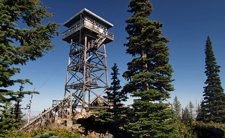
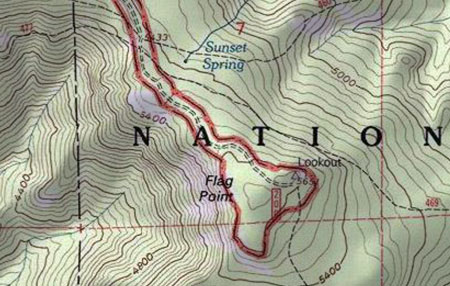
Though the lookouts and guard stations are mostly gone, the trail network still survives as the backbone of today’s recreation trail system. A few trails still lead to surviving lookouts scattered across the country. This article describes one such survivor, the Flag Point Lookout, located at 5,636 feet on a rocky, flat-topped bluff two miles east of Lookout Mountain.

The primitive road to Flag Point is surrounded on three sides by the Badger Creek Wilderness

The Flag Point Lookout is unique in that it continues to serve as an active fire lookout during the summer. The view from the lookout surveys a broad sweep of the eastern slopes of Lookout Mountain, far into the Eastern Oregon sagebrush and ranchland, and south into the rugged Badger Creek Wilderness.

The second structure on Flag Point was this L-4 cabin constructed in 1932, and later replaced by the current structure

Since the establishment of the Badger Creek Wilderness in 1984, The Flag Point lookout and the long, rugged 1930s-era dirt road leading to it have been surrounded on three sides by federally protected wilderness (The same 1984 legislation left two other surviving lookouts in the Mount Hood area, the Devils Peak and Bull of the Woods towers, inside new wilderness areas, where they are now maintained by volunteers as hiking destinations).

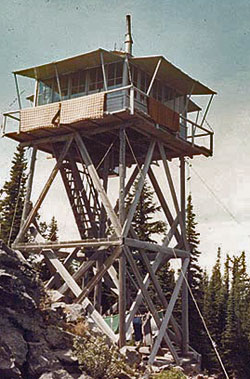
The first lookout structure at Flag Point was a six-foot square cabin on a 40-foot pole tower, built in 1924. It must have been terrifying in rough conditions, and was soon replaced with the popular L-4 style cabin (pictured above) on a 30-foot pole tower in 1932, a design that was found across Oregon.

Later improvements to the second tower were made in 1955, and a series of outbuildings were added over the years, replacing the original tent camp that accompanied the first structure.

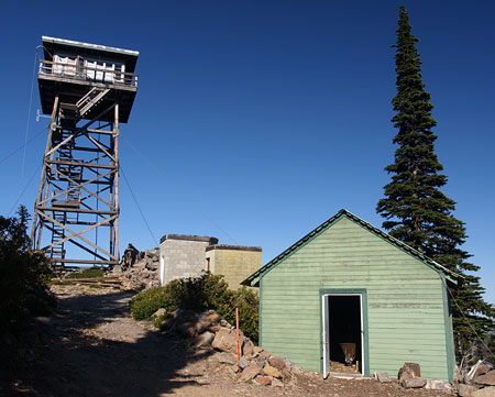
The current lookout tower and outbuildings at Flag Point

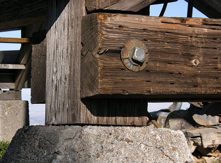
In 1973, the third and current lookout structure was built — an R-6 flat top cabin on a 41-foot tower constructed of sturdy, pressure-treated cross-timbers. Like many lookouts, the structure is primarily held in place by stay cables, and simply rests upon its four concrete foundation feet.

Though the current structure is still too young to be listed on the National Historic Register, it has been listed on the National Lookout Register. It will become eligible for the historic register in just 13 years, in 2023.

Amazingly, the tower is anchored by cables, and simply sits upon its four foundation piers

The Flag Point Lookout is also notable for the remarkable forest ecosystem that surrounds it, where stands of fir and mountain hemlock blend with western larch and ponderosa as east meets west. The rain shadow effect of the Cascade Range is plainly visible from Flag Point, where the sweeping view extends far into the sagebrush deserts of Eastern Oregon.

Ironically, these are fire forests, an ecosystem that has specifically evolved around wildfire cycles, and thus have suffered greatly from the well-intended “protection” from fire that the lookouts have provided. Today, natural fires in the Badger Creek Wilderness are likely to be allowed to burn, with the Forest Service intervening only when homes or private property outside the wilderness are threatened.

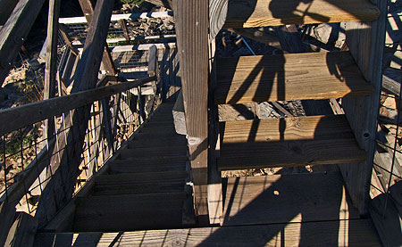
The plank staircases are beautifully constructed with rabbet and dado joints, and enclosed with galvanized steel mesh

Beneath the forest canopy, the wildflowers of Flag Point are as diverse as the conifers, with mountain and desert species mingling in the sunny, open meadows. The Divide Trail, connecting Flag Point to Lookout Mountain, provides one of the best wildflower hikes in the region in early summer, traversing through miles of meadows and rock gardens along the way.

Flag Point was an important forest destination in its time, and still serves as the hub for several forest trails that are a legacy of the early lookout era. In addition to the Divide Trail, the lookout has trails radiating to Ball Point, Gordon Butte and Badger Creek. Today, most visitors to the lookout arrive via the access road, but hikers and horse packers also regularly visit the lookout from this network of wilderness trails.

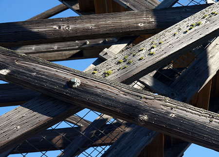
The key to the design of the Flag Point tower is a sturdy maze of treated cross-timbers

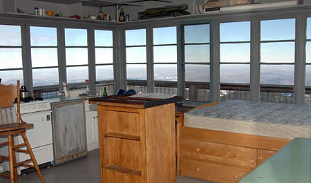
The cabin atop the Flag Point lookout consists of a 14-by-14 foot interior, surrounded by an airy exterior catwalk. Steel mesh fills the gap between catwalk railings, adding some degree of confidence for vertiginous visitors.

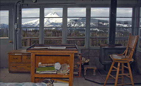
The small cabin is furnished with a bed, a wood stove for heat, gas cook stove, table and chair, and a solar lighting system — a modern amenity that early lookouts couldn’t have imagined.

Looking east, the view extends beyond the Cascades and across the Oregon desert country (USFS Photo)

At the center of the cabin is a map table that echoes the original Osborne fire finders used to pinpoint fire locations. Outside, a rope and pulley system is used to haul supplies and firewood to the catwalk from the base of the tower.

Water for drinking, cooking and washing must be hauled in to the tower by truck, though early lookouts simply carried water from the nearby Sunrise and Sunset springs. Outbuildings include an outhouse, woodshed and an A-frame communications shack has been added to the west of the tower.

The view to the west provides a spectacular look at Mount Hood and nearby Lookout Mountain (USFS Photo)

Visiting the Lookout

Anyone can visit the Flag Point Lookout by simply parking at the locked gate, and hiking about one quarter mile to the lookout complex. The tower is generally staffed from June 1 through October 15, so be courteous and let the lookout know you’re visiting before climbing the tower. If you’re lucky, the lookout will be on site and invite you up for a tour. If the tower is closed, you can still climb to the lower catwalk for a close-up look at the structure, and views of the surrounding terrain.

The Flag Point lookout also makes for an interesting add-on to the Divide Trail hike to Lookout Mountain. You can simply hike to the lookout along the Flag Point Road from the Divide Trail (about 3/4 mile each way), or shuttle your car to the gate, saving about a mile of road hiking, round-trip.

In winter, the Forest Service rents the lookout cabin to skiers looking for a rugged, remote experience. Of the handful of lookouts open as winter rentals, the Flag Point Lookout is one of the most challenging to reach. You can learn more about winter rentals at the lookout here.

Relic from a bygone era, this 1940s DeSoto is slowly fading into the forest near Flag Point, where it was mysteriously parked decades ago

How to Get There

Reaching the lookout is an adventure in its own right. The last few miles of forest roads are generally open from June through October. From Portland, drive east on US 26 through Government Camp, then follow Highway 35 across the White River, and down the East Fork Hood River valley, beyond the Meadows ski resort.

Turn east (right) on Road 44, where signs point to Dufur and Camp Baldwin, and follow this paved road for 8 miles to the poorly marked junction with Road 4420. Turn south (right) and follow this paved forest road as it eventually curves past the Fifteenmile Campground. Just beyond the sharp bend at the campground, watch for dirt road No. 200, heading abruptly uphill and to the right. This is the Flag Point road, and it bumps along for the next 3.5 miles to the lookout gate. Parking is available near the gate.

Note: unfortunately, the Forest Service has recently ditched this road with a series of water bars that make for very slow going, and make the trip a rough ride for passenger vehicles – take it slowly!

Proposal: South Fork Water Works Trail

Lower falls on the South Fork Clackamas River in 1963

In 1913, the young cities of Oregon City and West Linn suffered a serious outbreak of typhoid from an increasingly polluted Willamette River, their sole source of water at the time. The incident spurred Oregon City’s leaders to appoint a “Pure Mountain Water League” and directed it to locate a safer source of drinking water.

The League settled on the pristine South Fork of the Clackamas River in the Cascade foothills. The City of West Linn signed on with Oregon City, offering to pay for one third of the cost of a new pipeline to bring the South Fork water to the two cities. A South Fork Water Board was created to carry out this ambitious project.

By the fall of 1915, the new water district had managed to lay twenty-six miles of 18” pipe from a site at the confluence of Memaloose Creek and the South Fork Clackamas all the way to Oregon City and West Linn. The new pipeline began to carry municipal water on October 7, 1915.

Main falls on the South Fork Clackamas River in 1963

In 1939 the South Fork Water Board expanded the system with the help of one of Franklin Roosevelt’s New Deal recovery programs, the Works Project Administration. This project extended a 24” pipeline upstream from the Memaloose Creek intake to a point upstream, above the 120-foot main falls on the South Fork. This project involved carving a series of three dramatic tunnels and a cantilevered pipeline through solid basalt cliffs.

The new intake improved water pressure downstream, and this system continued to serve as the water supply for the two cities until a new filtration plant was constructed on the lower Clackamas River, in 1958. Both systems were used until 1985, when the South Fork pipeline was decommissioned. Since then, the network of roads, tunnels, plank walkways, log bridges and old pipeline has slowly been fading into the green rainforest of the South Fork canyon.

The story might have ended there, except for the series of spectacular series of waterfalls along the South Fork and Memaloose Creek. By the late 1990s, some of the region’s more adventurous kayakers had scouted both streams, and in the early 2000s, had documented the first known descent of the South Fork by kayak.

Main falls on the South Fork with hiker in 1923

These intrepid kayakers portaged the big waterfalls on the South Fork by following the abandoned tunnels and log bridges left behind by the South Fork Water Board. In doing so, they brought renewed interest to the area, as word of a high concentration of waterfalls spread to other adventurers.

In total, there are five major waterfalls along the final two miles of the South Fork, and two along the last mile of Memaloose Creek, where it flows into the South Fork. The old water works roads and tunnels reach two of the South Fork waterfalls, including the main 120-foot falls, as well as the main falls on Memaloose Creek. The remaining waterfalls are remote, and not reached by the water works roads.

The tunnels and roads along this system are entirely intact and walkable – as several explorers have now documented. A timber bridge over the South Fork at Memaloose Creek is also intact, and is now used by waterfall explorers to cross the stream. These old roads and tunnels offer a unique opportunity for a new trail system that could build on the existing network, and offer an unparalleled blend of natural spectacle, historical artifacts and lots of insight into the history of the South Fork water works project, itself.


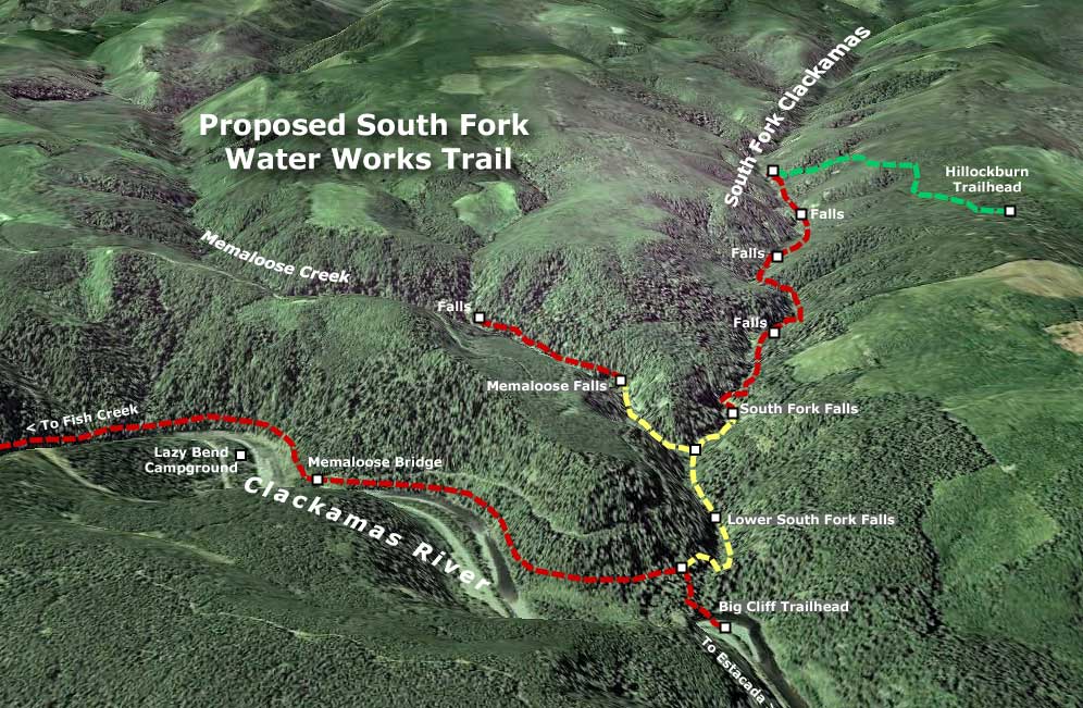
(Click here for a larger map)

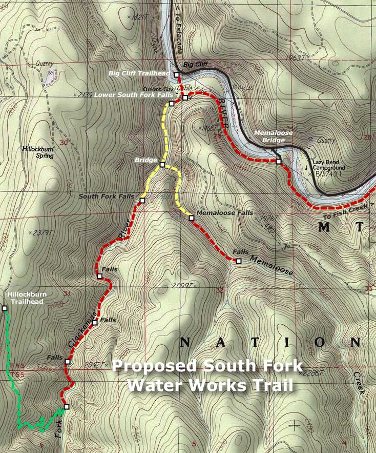
What would this trail look like? The accompanying maps (above and below) show the sections that would follow old water works grades in yellow. All of these roads have been recently scouted, and are in good shape, and thus easily converted to trails. The six tunnels along the way (one along Memaloose Creek and five along the South Fork) are also in good shape, and easily walked, although at two are long enough that a headlamp is required.

New trails would also be needed to complete the system, and are shown in red on the accompanying maps. A new trailhead and access trail would located on the east side of the Memaloose Bridge, following the Clackamas River downstream, then turning up the South Fork canyon and joining the converted water works grade at the lower South Fork falls (this section along the Clackamas would also serve as an extension of the Clackamas River Trail, extending east to Fish Creek, and the current trail terminus).

Two trail extensions would carry hikers deeper into the canyons of the South Fork Clackamas and Memaloose Creek, beyond the water works roads. A new Memaloose trail would climb a half-mile to a second falls, upstream from the main Memaloose falls. An extended South Fork trail would continue from the final waterworks tunnel, and travel 1.5 miles upstream along the west bank of the river, passing three remote waterfalls before ending at the existing Hillockburn Trail (shown in green on the maps).


(Click here for a larger map)

Look closely at the maps, and you will also see a proposal to add a trailhead at Big Cliff, along the Clackamas Highway, with a footbridge connecting across the Clackamas River to the new South Fork trail network. The concept here is to provide a family-oriented day-use area on this scenic bend in the river that serves as the long-term gateway to the South Fork canyon. Today, this spot is an eyesore – a huge dirt and gravel expanse that suffers from dumping, shooting and other unlawful behavior. The trailhead and day-use concept would turn this blank expanse into a place for families to explore the river and nearby trails, less than an hour Portland.

Future trailhead and day-use area at Big Cliff?

In deep, rocky canyons like the lower South Fork, building new trails is complex, costly and at odds with modern conservation ethics, where blasting a trail through cliffs is no longer an accepted practice. Thus, the ability to convert the water works roads would bring hikers into a landscape that probably would never be reached with modern trails. In many ways, the canyon is an accidental version of the venerable Eagle Creek Trail, in the Columbia Gorge, where the route is famously carved into the cliffs.

The logistics for this proposal are also fortuitous. The water works area of the lower South Fork canyon was specifically excluded from the 2009 Lewis & Clark wilderness act that set aside the upstream portions of the South Fork canyon as new wilderness. This means that while the upper canyon trail must be built with wilderness restrictions in mind, converting the roads, repairing bridges and preserving the historical artifacts in the lower canyon won’t be encumbered by wilderness restrictions.

This is a project whose time has come – in part, because the word is out about the scenic wonders of this beautiful canyon, but also because the historic features ought to be preserved before they are lost to time and the elements.

Proposal: Gorton Creek Accessible Trail

GortonCreek01

Emerald Falls on the proposed Gorton Creek Accessible Trail

The Mount Hood National Park Campaign proposes a major expansion of the trail system in the Columbia Gorge and around Mount Hood, including more opportunities for elderly, disabled and young families to experience nature. After all, hiking is the most basic form of active recreation, and should be available to all of us — especially as our region continues to grow and urbanize.

Proposed Gorton Creek Accessible Trail

Accessible trails are designed to provide access for everyone, and these facilities will be in growing demand as our country continues to age. By 2030, nearly a third of our population will be over the age of 55, and accessible trails will be in demand as never before.

In the spirit of providing accessible trails, this proposed new trail at Gorton Creek would allow for easy access to streamside vistas and photogenic Emerald Falls. This section of trail would bring visitors through a lush forest of Douglas fir, bigleaf maple and red alder.

GortonCreek02

Autumn on Gorton Creek as viewed from the proposed location of an accessible viewpoint

Gorton Creek becomes increasingly prominent as the trail draws near the stream and the sound of rushing water fills the air. Just below the proposed viewpoint of Emerald Falls and rushing Gorton Creek, there is a large gravel beach at a bend in the stream that could even provide the potential for universal access to the stream, itself — a first in the region.

The accessible portion of the new trail would largely follow an existing boot path that, in turn, follows a very old roadbed still shown on USGS maps. Thus, the gentle grade that would meet accessible trail design requirements. The dashed yellow line on the map, below, shows where the roadbed segment could be improved to provide universal access to a streamside overlook just below Emerald Falls.

GortonCreek03

Proposed Gorton Creek Family Trail

Family trails are designed to allow young children on foot, in backpacks or in strollers to have their first nature experience, and hopefully begin a lifetime of active recreation in nature.

The second part of the proposed Gorton Creek Trail would be designed for young families, with a short, easy grade leading to a viewing platform below Gorton Creek Falls. The falls is a towering 120 foot plunge set against a magnificent wall of columnar basalt, and would provide an exciting destination for budding young hikers. This section of proposed trail is shown in red on the map, above.

The family trail portion of this project would a couple of important objectives. First, it would provide a new hiking option for families with beginning hikers, with easy access from Portland and the potential to camp at Wyeth Campground as part of the adventure. Such trails are in surprisingly short supply in the Gorge, and therefore often crowded when families are most likely to visit, depriving them of a quality nature experience.

Second, this segment of the trail would combine with the lower, accessible segment to allow for extended family outings — grandparents enjoying the lower streamside viewpoint as young children and parents hike the short family spur to the main falls viewpoint, for example, with the extended family camping or picnicking at the Wyeth Campground.

Gorton Creek Restoration

While this proposal would meet growing needs for accessible trails in the region, it would remedy an escalating problem at Gorton Creek: the secret is out on Gorton Creek Falls, and waterfall enthusiasts are wreaking havoc on the trail-less canyon section above Emerald Falls as they scramble to reach the main falls, upstream. The damage to the canyon slopes (see photos, below) and stream bed is particularly worrisome given the important role the stream has as fish habitat.

GortonCreek04

Gorton Creek Falls is no longer a well-kept secret. Each summer, more visitors are pushing cross-country through the upper canyon, leaving damaged slopes and trampled vegetation in their wake

Finally, trail construction could also allow for the washed-out waterworks at Emerald Falls (see photo, below) to be permanently relocated within the trail corridor, and less prone to the periodic failures that plague the current streamside alignment. The water pipeline is currently in a precarious condition, and would greatly benefit from a trail project happening in this canyon sooner than later.

GortonCreek05

The washed out water supply line for Wyeth Campground hangs from cables anchored to stakes below Emerald Falls

To visit Gorton Creek, drive east of Cascade Locks to the Wyeth exit, turn right, then turn right again on the old highway that parallels I-84. Watch for the Wyeth Campground on the left, just before a bridge over Gorton Creek. If the campground gate is closed, park to the side, and walk through the campground to the well-marked trailhead at the south end — otherwise, you can drive to the trailhead.

To reach Emerald Falls, follow the formal trail 0.1 miles to a junction with Trail No. 400, where it crosses Gorton Creek on an impressive footbridge that kids will want to explore. Continue straight, past the bridge and Trail 400, following the obvious footpath up the east side of the stream canyon for another 0.4 miles. Watch your step around Emerald Falls, as the water works erosion has left abrupt holes and weakened stream banks. Do the canyon a favor, and don’t scramble upstream to Gorton Creek — wait for a trail to be built, instead!

(Editors Note: Trail No. 408 already carries the name “Gorton Creek Trail”, but never comes close to the creek, traversing high above the canyon rim on the shoulder of Nick Eaton Ridge. This trail eventually climbs to the summit of Green Point Mountain — and thus, might be better named the “Green Point Mountain Trail” should a new trail along Gorton Creek become a reality, if not before)

Tiny Timberline Survivors

TinyTimberline00

Bright yellow Sulphur Flower carpet the slopes below Palmer Glacier in August

During the peak of summer in the high country around Mount Hood, hikers flock to the lush mountain meadows in places like Paradise Park, Cairn Basin, Elk Cove and Elk Meadows to take in the huge drifts of waist-deep wildflowers. Along the way, they usually pass through the cinder slopes and glacial moraines that seem barren in comparison, but in fact are home to some of the toughest survivors of the wildflower community.

These diminutive flowers are incredibly rugged, resilient plants that somehow manage to persist in the harshest of alpine environments, cheerfully blooming each August during a snow-free growing season that spans only three or four months. Most are perennials, persisting from summer to summer, despite a thick snow pack for much of the year.

Their tiny size is but one of their adaptations to the extreme conditions that exist above the tree line. Most also feature long taproots that anchor them deep in the loose mountain soil, and thick, leathery leaves that help conserve water while maximizing photosynthesis during the very short growing season.

There are a number of tough species in this community of survivors, but the following are seven that are among the most common and interesting, and worth getting to know. These plants were all photographed on the same August evening, high on the south slopes of Mount Hood.

TinyTimberline01

Creeping Penstemon (Penstemon davidsonii)

Creeping Penstemon
This tiny flower grows just six inches tall, though its woody stems are almost shrub-like, and allow the plants to form carpets several feet across, usually on the protected side of a boulder. The oval, evergreen leaves are small and leathery, and also seem almost shrub-like, resembling tiny rhododendron leaves. The flowers can range in hue from lavender to nearly pink, and bloom in short spikes in early and mid-summer.

TinyTimberline02

Desert Parsley (Lomatium martindalei)

Desert Parsley
This little plant (also called Few-Fruited Desert Parsley) also grows in loose sand or pumice at the tree line, and is anchored by a large taproot that can up to a foot long. The thick roots of wild parsleys were collected by Native Americans as a food. Desert Parsley is most notable for its graceful, fernlike leaves, but also sports bright yellow blossoms in mid-summer. The plant is rarely more than four or five inches high.

TinyTimberline03

Low Mountain Lupine (Lupinus lepidus)

Low Mountain Lupine
This wonderfully tiny lupine is an obvious cousin to its many tall relatives, except that it grows no more than three or four inches tall. The tiny leaflets resemble the large, palmate leaves of larger lupines, except that they are the size of a button. The leaves are also covered in soft, silvery velvet that further helps the plants conserve water. The plants are anchored by a long taproot, like most alpine dwarfs. Their blossoms are globe-shaped, like a clover, though clearly related to the tall flower spikes of their larger cousins. Low Mountain Lupine blooms from early August through early September.

TinyTimberline04

Partridge Foot (Luetkea pectinata)

Partridge Foot
This delicate plant can form an extensive groundcover below timberline, but also blankets moist spots in the harsh country above the tree line, especially where melting snow trickles in small streams across rocky slopes. Partridge Foot is only a few inches tall, with creamy white flower spikes reaching 3-4 inches in mid-summer. The common name comes from the shape if its leaves, which apparently resemble a bird’s foot.

TinyTimberline05

Pussypaws (Spraguea umbellate)

Pussypaws
This tiny wildflower also has a self-evident common name, owing to the soft, fleshy, paw-shaped leaves that help the plant store moisture in its harsh habitat. In mid-summer, Pussypaws are covered with tufts of pom-pom flowers that open white, then fade to rose-pink. These little plants are no more than two inches high, with flower stems reaching three or four inches. It thrives in nearly soil-less pumice, and has an amazing taproot that can be as long as ten feet!

TinyTimberline06

Spreading Phlox (Phlox diffusa)

Spreading Phlox
Easily the lowest alpine flower, Spreading Phlox grow in a mat just 1-3 inches high, with their stunny explosion of cheery blossoms literally covering the plants in early August. The button-like flowers range from white to blue, with all shades of pink and violet between. Like its alpine neighbors, Spreading Phlox is deeply rooted, and thus well adapted to the dry, loose pumice and sandy slopes that it thrives in.

TinyTimberline07

Suphur Flower (Erigonum umbellatum)

Sulphur Flower
Also known as Sulphur Buckwheat, this is a tough survivor that lives in the least hospitable reaches of the alpine environment. This plant has silvery leaves covered with tiny hairs that help conserve moisture, allowing the plants to grow in what seem to be impossible habitats — from cracks between rocks and in loose scrabble on moraines. The flowers can range from cream to yellow, and light up slopes in early summer, before fading to a rosy hue. The top photo in this post shows a colony of Sulpher Flower on Mount Hood’s dry south slopes.

How to See Them
These timberline survivors can be seen all around Mount Hood, and on some of the higher surrounding peaks, too, such as Lookout Mountain and the high spots in the Columbia Gorge that reach above the tree line.

An easy way to see these plants up close is to explore the trails around Timberline Lodge. Several paved footpaths circle the lodge, and head up the mountain from the back of the lodge. You can follow one all the way to Silcox Hut, which is located far above the tree line, but still features many of these tiny flowers along the way.

Another option from Timberline is to follow the Pacific Crest Trail (PCT) south from the lodge, crossing the glacial headwaters of the Salmon River then to an impressive overlook of the White River canyon. This section of the PCT is lined with these tiny alpine survivors. Visit these trails in early August, and you’re guaranteed to see them in bloom.

Dry Creek Ponds: Orphaned Gems

Dry Creek flows into a series of lush ponds just south of I-84.

Dry Creek flows into a series of lush ponds just south of I-84.

Just inside the city limits of Cascade Locks — and just outside the protection of the Columbia Gorge National Scenic area — lie a series of beautiful ponds and an adjacent group natural springs so pure that a national bottled water corporation is considering a new plant here. The ponds, themselves, are posted with real estate signs advertising dream home sites in this pretty location, albeit within earshot of noisy I-84.

The ponds underscore one of the dilemmas facing natural sites in the Columbia Gorge that happen to fall within the designated “urban areas” that are excluded from scenic area protection. Most of the Gorge towns are too small to have the fiscal means to protect these orphaned gems, even if they wanted to. Meanwhile, the non-profit organizations and federal agencies involved in land acquisition focus exclusively outside these urban areas. The result is a surprising number of natural features that face great risk of development, with no clear path for protection.

Dry Creek is better known for its waterfall, about a mile upstream from the ponds.

Dry Creek is better known for its waterfall, about a mile upstream from the ponds.

In the case of the Dry Creek Ponds, much of the land is already up for sale, and the real question is whether some sort of public purchase could intervene, and save the ponds from development. The ponds are not entirely pristine: a frontage road along I-84 borders one of the ponds, and there are a few homes tucked into the forest near the ponds. But the ponds are largely undeveloped, and surely worth more to the public as protected natural areas than to a few as exclusive home sites.

One option for protecting the ponds is the federal acquisition program operated by the Forest Service to consolidate lands within the scenic area. Their guidelines focus outside the urban areas, but a case could easily be made to cross those boundaries when natural sites are adjacent to surrounding public land. This is the case for the Dry Creek ponds, which not only abut the scenic area, but also the federal Oxbow fish hatchery.

Dry Creek ponds are located outside the protection of both the National Scenic Area boundary and the nearby Oxbow fish hatchery.

Dry Creek ponds are located outside the protection of both the National Scenic Area boundary and the nearby Oxbow fish hatchery.

A second option for protection are the private agencies involved in land acquisition within the scenic area. These organizations typically turn most of their acquisitions over to the federal government for long-management, so in the case of the Dry Creek Ponds, it would still be important to find a way for federal acquisitions to exist inside the urban areas.

A third option is for local governments to step up to the challenge, and create a municipal park or natural area for its local citizenry. In this case, the City of Cascade Locks is the local government in question, and like most of the small cities in the Gorge, is financially strapped. So a hybrid approach where the federal agencies, or perhaps the non-profits (or both) help the small cities make strategic acquisitions of places like the Dry Creek Ponds.

The ponds are teeming with wildlife, despite the noise of the nearby freeway.

The ponds are teeming with wildlife, despite the noise of the nearby freeway.

One of the truisms about sudden growth in small communities like Cascade Locks is that the civic awareness of threats to natural areas usually comes too late in the development boom. After years of slow growth, Cascade Locks is slowly awakening. So, like other Gorge communities, the town is entering a short window of opportunity for natural area protection that will be fleeting.

The Dry Creek Ponds are worth saving. The ponds are home to waterfowl, beaver and a thriving population of other species in the wetlands and forest that border the ponds. The ponds are unique in having such close proximity to Cascade Locks, and therefore easy access for visitors. This is one of only a few places in the Gorge where it is easy to get very close to a pond ecosystem, and thus could provide a valuable place for learning and wildlife watching.

Wetland birds thrive in tall marshes that border the ponds.

Wetland birds thrive in tall marshes that border the ponds.

The ponds could also provide a starting point for hikers to head up Dry Creek to the falls — or points beyond along the Pacific Crest Trail, which passes just above the ponds, inside the scenic area.

In the end, the fate of the ponds will be a measure of our collective will to protect the larger Gorge landscape for generations to come, no matter where we’ve drawn lines on maps or how we have divided public land management responsibilities. In this way, the ponds provide an opportunity for local citizens, public land stewards and non-profit environmental advocates to show that our collective vision extends across those artificial boundaries.

Restoring forests, one community at a time

Interior Secretary Ken Salazar set the Pacific Northwest forest recovery effort back on track in July when he reversed the Bureau of Land Management’s (BLM) Western Oregon Plan Revisions (the WOPR, a brilliantly unintentional blunder as acronyms go, as it became known as “The Whopper”). This represented a major step back from scientifically corrupt policies intended to enrich timber corporations at great cost to our public lands.

In this recent opinion piece in The Oregonian, Dominick DellaSala and Randi Spivak respond to Salazar’s move, and provide an excellent framework for how we should move forward to restore our public forests. Their prescription: emphasize needed thinning of the sickly, biologically sterile tree plantations left from the logging heyday of past decades, and embrace the value that our restored forests will have in the global effort to reduce carbon emissions.

The eastside forests spreading out below Lookout Mountain look healthy enough from a distance, but in reality are in dire need of a bold new restoration strategy.

The eastside forests spreading out below Lookout Mountain look healthy enough from a distance, but in reality are in dire need of a bold new restoration strategy.

As described in their article, the Siuslaw National Forest has already begun to embrace this new approach, and other public forest managers are beginning to take notice. But a truly comprehensive restoration effort must be more aggressive, and should also focus on stabilizing the forest-based communities that were left to die when the big timber operations pulled out in the 1980s and 90s

Traditional thinning offers a couple of opportunities for local communities: the timber operations involve most of the same logging skills that were once the mainstay of rural Oregon. In addition, the harvested wood from thinning offers not only traditional saw logs for small mills, but also a new economic niche in the smaller woody debris that was once discarded or burned on site in the forests. New uses for small woody debris include engineered wood products and even energy production as biomass.

A closer view of typical second-growth forests near Lookout Mountain reveals a dying, overcrowded ecosystem under great biological stress.

A closer view of typical second-growth forests near Lookout Mountain reveals a dying, overcrowded ecosystem under great biological stress.

One practical challenge in reaching this new approach will be the scaled-back network of logging roads, since the over-built system constructed in the second half of the 1900s is rapidly crumbling and infeasible to maintain for the long term. One strategy is to tie road decommissioning to forest thinning and restoration efforts, pulling out obsolete roads after forests have been largely restored. Another could be aerial operations, perhaps even balloon logging. Still another could be roadless logging with light equipment or even horses — a practice well established on small, private woodlots in Oregon.

The key to finding this new balance in sustainable forest restoration a role of direct stewardship among the forest communities — to view them as the keepers of the forest, as opposed to the “forest dependent” mindset of the industrial logging era. This means establishing an ongoing relationship between community-based forest management organizations and the federal agencies that govern most of our public forest land. These new organizations could follow the lead of watershed councils and farm bureaus, using formal governance coupled with direct management responsibilities as forest recovery agents.

A bright spot in the restoration of the eastside forests near lookout mountain, this thinned plantation is beginning to resemble a natural forest, with multi-aged stands and a recovering understory.

A bright spot in the restoration of the eastside forests near lookout mountain, this thinned plantation is beginning to resemble a natural forest, with multi-aged stands and a recovering understory.

How would the economics of community-based stewardship work? In a commodity-based model of selling products recovered from thinning, the objective is straightforward — but unlikely to be profitable as a private enterprise.

Instead, the public will likely need to provide some level of subsidy for the restoration work involved, with commodity proceeds offsetting public costs. The advantage of a public subsidy is that it provides an ongoing public interest in the health and viability of the forest communities, themselves, and could help avoid the volatility that private timber harvesting brought to these communities in their first century.

A few stands of late succession ponderosa and Western larch forest still exist on the slopes of Lookout Mountain, providing a glimpse of what a restoration policy must aim for.

A few stands of late succession ponderosa and Western larch forest still exist on the slopes of Lookout Mountain, providing a glimpse of what a restoration policy must aim for.

But the more interesting idea is to create a long-term financial model for stewardship communities based on carbon sequestration as part of global efforts to reduce carbon emissions. Carbon credits would be sold as offsets to carbon polluters, and providing a permanent incentive to bring the northwest forests back to health.

The credits could be managed as a community trust, or managed through a public-private corporation. Under this paradigm, there would be little incentive to harvest large trees, since they would exist primarily as carbon storage units under the new carbon-based economic framework.

Of course, we also know that big trees and mature forests also provide a much wider array of ecological and social benefits, but these costs have never factored in to the short-term price for raw logs in the old timber harvesting paradigm. As DellaSala and Spivak point out in their article, the Pacific Northwest is uniquely capable of storing carbon in our living forests, and to a degree nearly unmatched in the world. If this potential is given a value, then we may well seen an end to the destruction of our mature forests for saw logs and pulp that could just as easily be manufactured from private plantation materials.

The concept of community-based stewardship in carrying out forest restoration is attainable, as evidenced by the many successful public-private partnerships that exist today. But it’s unclear if the Forest Service and BLM bureaucracies are flexible or willing enough to embrace the idea.

Instead, a new conservation-based form of administration may be needed — broader than the National Park Service in scope, but borrowing from the Park Service ethic of conservation and sustainability. The Cascade Forest Preserve, perhaps, extending from the Sierras to the Canadian border? Given the grave implications of climate change, it is impossible to think too big or boldly as we search for a way forward.