Proposal: Mark O. Hatfield Memorial Trail

Senator Mark O. Hatfield campaigning in 1967

One of the legacies of former Oregon Senator Mark O. Hatfield was expansion of the state’s wilderness system in 1978 and 1984, the largest expansion before or since that time. Though Hatfield was harshly criticized by conservationists for also sponsoring pro-logging legislation that led to the destruction of ancient forests, his role in creating new wilderness in Oregon remains a singular achievement that no other senator has yet matched.

To honor the senator, Congress renamed one of these new wilderness areas, the former Columbia Wilderness, as the Mark O. Hatfield Wilderness in 1996. This recognition marked the senator’s retirement from Congress after nearly a half century of public service that included serving as an Oregon legislator, Oregon’s Secretary of State, then Governor, before finally being elected to the U.S. Senate in 1967, where he served for 30 years

Senator Hatfield with wife Antoinette in 2008 (Willamette University)

The recognition also triggered another round of critiques by conservationists over Hatfield’s environmental legacy. But for many, it was also a fitting tribute to the senator who had pushed the Columbia River Gorge Scenic Act through Congress in the 1980s when it would have been easy for the Oregon Republican to simply leave the task to his Democratic counterparts.

Hatfield’s long service, and his independent stance on a number of topics, forced him to break ranks with the Republican Party on a number of progressive issues. These ranged from successfully sponsoring Oregon’s landmark civil rights legislation in 1954 (a full decade ahead of the U.S. Civil Rights Act) to his early opposition to American involvement in the Vietnam conflict, and later, the Gulf War.

His independence and principled “sanctity of life” stance that led him to champion civil rights for minorities and gays, while opposing wars, the death penalty and abortion later earned him his own chapter in Tom Brokaw’s “The Greatest Generation”.
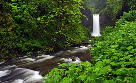
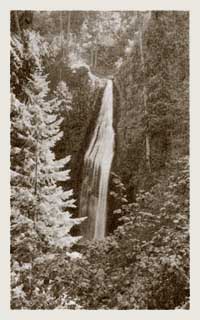
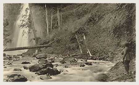
Multnomah Creek along the proposed Hatfield Trail

Though his environmental legacy is a conflicted one, Hatfield’s landmark environmental protections in Oregon still exceed that of his fellow Democrats, who claim the natural constituency of environmentalists, but have seldom acted with such determination and vision.

The Mark O. Hatfield Wilderness originally spanned the most remote high country on the Oregon side of the Columbia River Gorge, but in 2009, President Obama signed a new wilderness bill into law that expanded the Hatfield wilderness significantly. The new boundary stretches the Hatfield Wilderness from Larch Mountain and Multnomah Creek on the west to the steep ridges and canyons of Mount Defiance, on the east.

The Concept

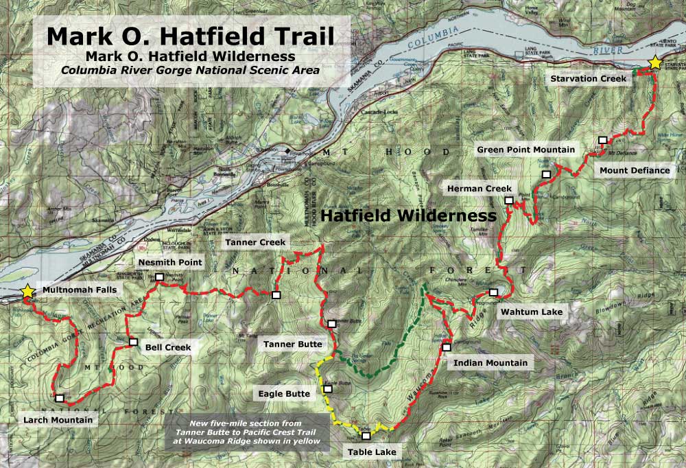
This Mark O. Hatfield Trail proposal is for a 60-mile memorial trail that spans the Hatfield Wilderness, beginning at Multnomah Falls and culminating at Starvation Creek Falls, passing through the most rugged, lonely country to be found in the Columbia River Gorge along the way. This new trail would join classic hikes like the Timberline Trail at Mount Hood and the Wonderland Trail at Mount Rainier as premier backpacking destinations of national prominence.
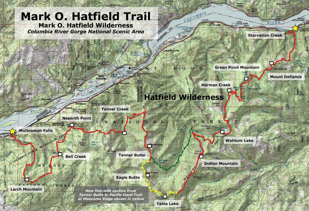
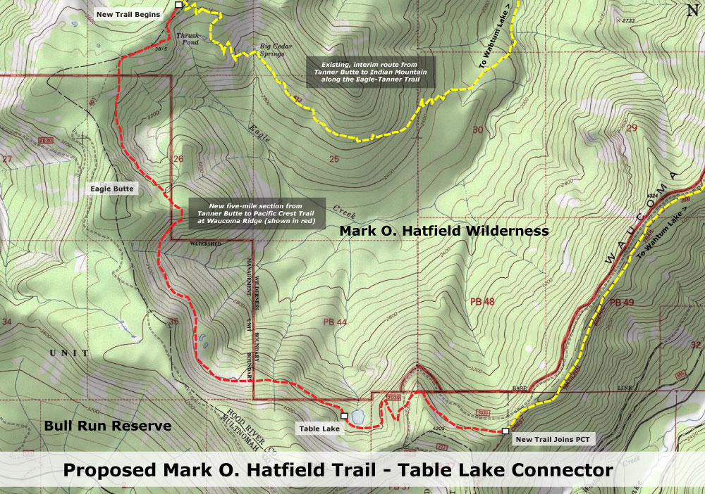
(click here to view a larger map)

The new trail would largely be assembled from existing routes, but with a notable exception: a new, five-mile segment would curve just inside the Bull Run Reserve, along the headwaters of Eagle Creek. The new segment would bring hikers to little known Eagle Butte and rare views into the Eagle Creek backcountry that few have seen before.

Though this new trail segment would not physically enter the Bull Run watershed, it would nonetheless pass inside the reserve boundary. This would require special approval by the U.S. Forest Service, similar to that given the Pacific Crest Trail, where it crosses along the edge of Bull Run. Simply raising the issue might even challenge the absurd notion that trails and hikers present a risk to the watershed – a separate topic for another column!
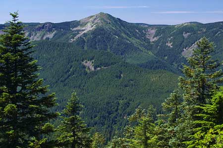
Rugged Tanner Butte in the Hatfield Wilderness

Along the route, there are also many trails that would be “saved” by this proposal – routes that have been badly neglected for decades, but deserve to be maintained. In some spots, short realignments would be needed to improve old or confusing sections. In the area of Starvation Creek, for example, a redesigned trail along the final stretch near I-84 is needed to improve on the current, rather jarring re-entry into civilization.

The Trail

The 60-mile route is designed as a six-day trek, beginning at the Multnomah Falls Lodge, then leaving civilization behind for most of the next six days as the route traverses through the rugged high country of the Hatfield Wilderness.

The following trip log shows the most prominent landmarks along the trail, with proposed camp spots for five nights on the trail. The up-and-down elevation changes inherent to the Hatfield Wilderness terrain will make this a challenging trek for any hiker. Segment and cumulative mileage is shown, along with net elevation gains and losses:

Day 1 to Bell Creek: the 60-mile trek would begin along the very popular Larch Mountain Trail, following Multnomah Creek beyond the reach of the throngs at Multnomah Falls, then climbing to historic Sherrard Point on Larch Mountain, another popular tourist destination. From here, the trail leaves the tourists behind, dropping into ancient forests along Bell Creek and the first campsite at 10.5 miles.

Day 2 to Dublin Lake: this is the most strenuous day along the circuit, covering 12.8 miles as the trail climbs over the shoulder of Nesmith Point, drops into Tanner Creek canyon, then climbs out again to arrive at Dublin Lake. At Nesmith Point, hikers can look down on the Columbia River nearly 4,000 feet below from the highest point on the Gorge rim, and on Van Ahn Rim hikers will get a rare look into the backcountry of the Tanner Creek canyon and into the Bull Run Reserve.
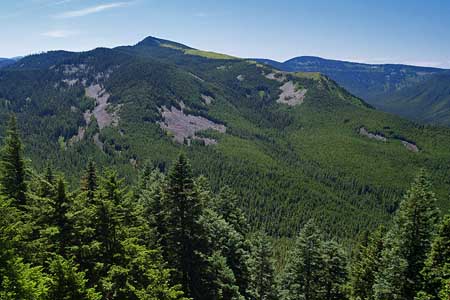
Indian Mountain with Eagle Butte in the distance

Day 3 to Table Lake: the third day of the proposed Hatfield Trail is a less challenging 9-mile hike along the high ridges of the Eagle Creek backcountry, allowing time for the spectacular side trip to Tanner Butte, along the way. The new trail segment begins north of Tanner Butte, and traverses across the rugged talus slopes and mountain tarns of Eagle Butte and Table Mountain, with expansive views into the Eagle Creek canyon, 3,000 feet below. The campsite for this proposed new segment is inside the Bull Run Reserve, at little-known Table Lake. Though the trail is inside the Bull Run boundary, the entirely of the trail is within the upper reaches of the Eagle Creek drainage, and is outside the physical watershed of the Bull Run.

Day 4 to Herman Creek: on the fourth day, the route joins the Pacific Crest Trail and passes high over the shoulder of Indian Mountain, then drops to popular Wahtum Lake. The lake provides a midpoint trailhead access for those looking for a shorter trip, an alternative camping spot or possibly a feed drop for those planning stock trips along the trail. From Wahtum Lake, the trail climbs over Anthill Ridge, then descends past Mud Lake before reaching a campsite at Herman Creek at the 12.6 miles.
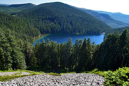
Wahtum Lake from Anthill Ridge along the proposed Hatfield Trail

Day 5 to Warren Lake: this is also a less demanding day, with most of the climbing in the first few miles, as the route climbs out of the Herman Creek canyon, and passes the rocky summit of Green Point Mountain, with expansive views of the surrounding wilderness. From here, the route passes above Rainy, North and Bear lakes before curving around the rocky north face of Mount Defiance, then dropping to beautiful Warren Lake at 9.5 miles.

While the recommended circuit includes a night at Warren Lake to enjoy the exceptionally rugged setting and wilderness scenery, the relatively short, final leg to Starvation Creek will draw many hikers to make this a 5-day trip, and skip the final campsite at Warren Lake. For these hikers, the lake might simply offer the opportunity for a quick swim before heading back to civilization.

Bear Lake and Mount Defiance along the proposed Hatfield Trail

Day 6 to Starvation Creek: the short, 5.6 mile final leg travels steeply down the north slope of Mount Defiance along Starvation Ridge, dropping 3,600 feet in just over five miles. Along the way, the trail passes above dizzying cliff-top viewpoints and shady side-canyon waterfalls before reaching the Columbia River and the end of the trail at Starvation Creek.

The restrooms, telephone, easy highway access and shady, un-crowded streamside picnic sites below lofty Starvation Creek Falls make this an ideal terminus for hikers seeking to relax after their adventure.

The following table summarizes the recommended 6-day hike, with running mileage and daily elevation gains:

What would it take?

Much of the trail network described is exceptional in scenic value, but suffers from years of deferred maintenance and modernization. Since most of the route is already in place, the Mark O. Hatfield trail concept would mostly require a stepped up commitment to maintaining and improving existing routes.

This would include basic maintenance, like brushing out overgrown routes, tread repair and drainage, but would also new signage and log bridges across major streams, consistent with the Wilderness Act . This work could begin immediately, but will require funding, as the route is generally too remote and rugged to depend entirely on volunteer labor.
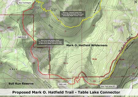
(Click here for a larger map of the new trail)

Constructing the new 5-mile segment proposed inside the Bull Run Reserve is the boldest element of this proposal, and a tall order for the federal bureaucracy. However, a simple interim plan is to route the new trail along the existing Eagle/Tanner (No. 433) and Indian Spring (No. 435) trails. These trails are shown in yellow on the map, above, and in green on the map showing the entire Hatfield Trail proposal.

This interim route would reduce the total hike distance by about two miles, and add about 1,000 feet of elevation gain. However, the interim option would allow for full implementation the Hatfield Trail concept in the near term, rather than waiting for the bureaucracy to address the watershed issue.
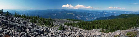
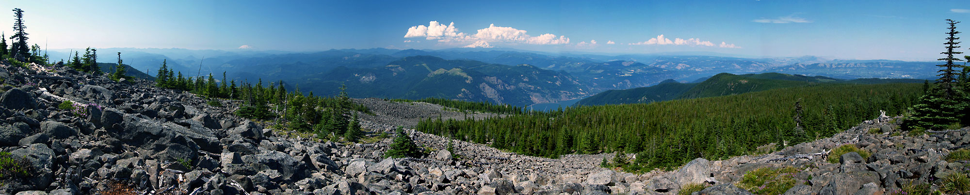
Columbia River from rugged Mount Defiance, near Warren Lake

(Click here for a large view of the panorama)

Another possibility for the long term is to finally complete the long-stalled Gorge Trail (No. 400) connection from Wyeth to Starvation Creek. This missing piece is a segment that would curve around the steep face of Shellrock Mountain (the focus of a future WyEast Blog article), creating a 30-mile trail connection from Multnomah Falls to Starvation Creek.

This connection would allow for a loop hike for hardy backpackers looking for a 90-mile backpack. However, because substantial portions of the existing Gorge Trail 400 are exposed to freeway noise and other reminders of civilization, the loop is not included in the Mark O. Hatfield Trail concept.

Why now?

This isn’t a difficult project to realize, and it would pay fitting tribute to begin work on this concept in time for Senator Hatfield to personally see the project begin – possibly even to participate in the ground breaking.

Accomplishing this project would be well-deserved recognition for the heavy lifting he did as our senator to protect the Columbia Gorge and Oregon’s wilderness for generations to come. The better question: why not now?

Stop Salting the Palmer Glacier!

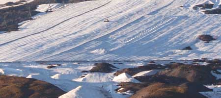
The plowed surface of the Palmer Glacier shows up on summer evening view of Mount Hood’s south face

A recent article in Willamette Week by Adrienne So goes where The Oregonian and other media have not dared in the nearly 30 years since the controversial Palmer Lift opened the Palmer Glacier to year-round skiing. In her article, So asks the obvious question: is it really such a good idea to pour nearly a million pounds of salt on the glacier each summer to melt the ice for skiers?
But So also asks the more maddening question: how can it be that the Forest Service and Oregon Department of Environmental Quality (DEQ) are fine with this practice? The sad answer lies in the cozy relationship the Forest Service maintains with the ski resorts and the ironic fact that the DEQ can only regulate the salting when damage finally shows up downstream. In other words, when it’s too late.

The Palmer Glacier is not the smallest on Mount Hood, but surely the most fragile thanks to its low elevation and southern exposure

What lies downstream from the Palmer Glacier? Initially, a steep maze of alpine canyons carries melt water from the glacier to the tree line. Soon, these mountain streams combine to become the Salmon River. The river flows just a few miles before reaching Red Top Meadows. A short distance beyond, the river enters wilderness and the broad expanse of Salmon River Meadows, by far the largest wetland complex on Mount Hood.

From the meadows, the rapidly growing river turns west, then drops into one of the wildest, deepest canyons in Oregon, thundering over a string of tall waterfalls that are so remote as to have only been discovered in the 1960s. The Salmon River National Recreation Trail follows the canyon section, and is among the most popular hikes in the Pacific Northwest, year-round.

Beyond the steep gorge section, the river slows and broadens, rambling through ancient forests where it is recognized as one of the state’s premier salmon and steelhead habitats. Here, it is strictly managed for its fisheries with special seasons and limits. Trails follow the river in this section, too, leading to shady forest camps and fishing holes. The giant cedar groves along the lower river are the most accessible ancient forest in the region, just 45 minutes from Portland.

For their part, the Timberline operators make a point of never calling the Palmer Glacier by its true name. Instead, they use the term “Palmer Snowfield” in their marketing, apparently to downplay the fact that their summertime skiing is putting one of Mount Hood’s most vulnerable glaciers at risk.

Since the construction of the Palmer Lift, Timberline ski resort operators have plowed the Palmer Glacier like an icy farm field, with the benefit of salt to soften the surface

The motivations of the Timberline resort are easy enough to understand: it’s a commercial venture (albeit on public land and in a public structure), and they are not in the business of protecting the Salmon River ecosystem for the public at large. The salting makes money for the Timberline resort, after all, or they wouldn’t do it.

But to wrap your head around the Forest Service policy of allowing the salting is to believe that dumping just under 500 tons of salt (that’s about 500 pickup loads) on Palmer Glacier each year won’t have an environmental impact. That the impacts could extend from the headwaters of this river complex to the pristine meadows, forests, waterfalls and fisheries that lie below makes the policy that much more appalling.

As destructive and shortsighted as this policy seem, there’s really nothing you and I can do about it – at least not until the salt starts showing up downstream in concentrations that constitute “pollution”. If that seems like a Catch-22, well, that’s because it is.

In the meantime, the only available alternative is awareness. You can start by reading So’s excellent article, over here (PDF):

Salt and a Wound: Summertime and salting is easy on Palmer Glacier

Next, share what you learn with those who love Mount Hood – and especially those who ski at the Timberline resort. It’s likely they don’t even know about this obviously reckless practice, and Timberline hasn’t been particularly up-front about it.

Next, print this bumper (or rear-window) sticker to kick off your own awareness campaign:

Click here for a bumper-sized version to print

There’s a worn adage that when you find yourself at the bottom of a hole, the first thing to do is stop digging. Until more is understood about the impacts of the salting practice on the Palmer Glacier and the sensitive environments that lie downstream, it’s time to stop the salting. Now.

Restoring Warren Creek Falls

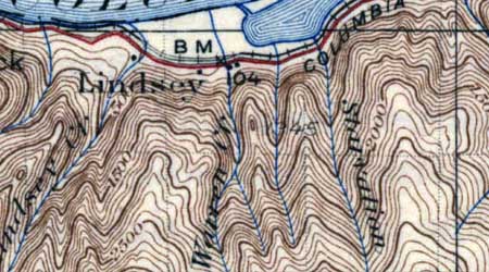
Early 1900s map of Warren Creek, before the falls was diverted

Until the 1930s, Warren Creek was much like it’s neighbors to the east and west in the Columbia River Gorge, plunging in a spectacular waterfall as it reached the final wall of cliffs lining the river. For millennia, the stream had slowly carved a huge amphitheater in sheer basalt, thundering into a deep splash pool at the base of the cliffs, before rushing to the Columbia.

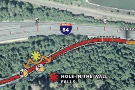
The railroads crossed Warren Creek in the late 1800s, and by the 1920s, Samuel Lancaster’s iconic Historic Columbia River Highway had been constructed, and passed the stream near the falls. Sometime in the late 1930s, the Oregon Highway Department determined that Warren Creek posed a risk to the highway grade, and made the improbable decision to re-route the falls through a tunnel, depositing the stream a few hundred yards to the west.

Man-made Hole-in-the-Wall Falls flows from a tunnel

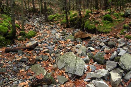
The legacy of this bizarre project is man-made waterfall now known as Hole-in-the-Wall Falls, for the fact that Warren Creek continues to burst out of the diversion tunnel blasted in the 1930s. The true falls are still “upstream”, so to speak — the streambed of Warren Creek above the man-made diversion is now dry, though it looks to have flowed yesterday.

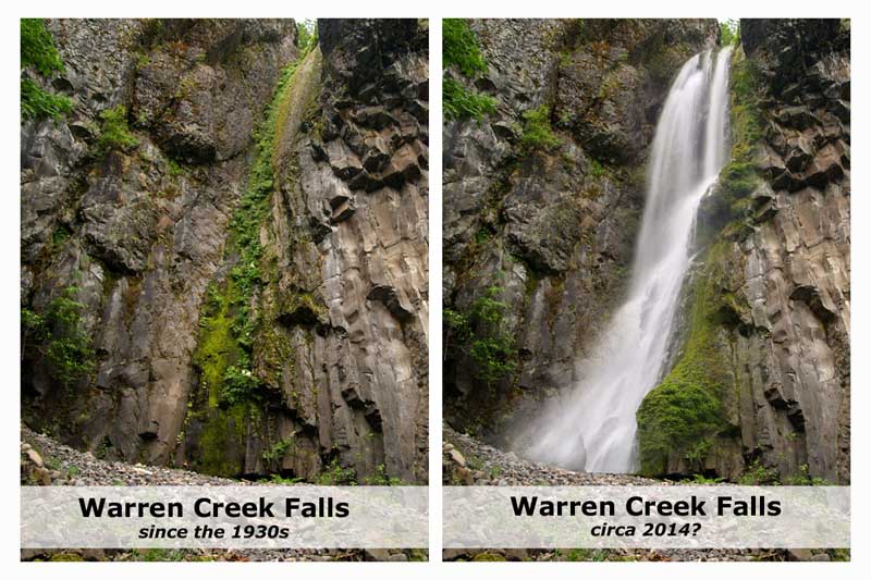
At the head of the dry streambed, the former Warren Creek Falls also looks as if it flowed recently, even though the diversion has been in place for more than 70 years. A bright green ribbon of moss and ferns traces the graceful chute where a horsetail-shaped falls once roared down the cliffs. A huge mound of debris has since accumulated at the base of the falls, perhaps from occasional overflows of the weir above the falls that normally directs the stream flow to the diversion tunnel.

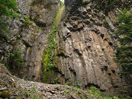
The dramatic basalt amphitheater of Warren Creek Falls

Someday, a natural storm or geologic event will surely block the tunnel, or destroy the weir, and Warren Creek Falls will once again flow through its magnificent grotto. But why wait? What better statement of our dedication to healing the misguided scars of the human past than to bring back this lovely waterfall?

The benefits would be many. First, the natural setting of the falls is unique and spectacular, and would become an instant destination for hikers and waterfall lovers. Though there are hundreds of waterfalls pouring over basalt cliffs in the Gorge, the basalt columns at Warren Creek Falls are especially dramatic. Restoring the falls would also add back several hundred yards of salmon and steelhead habitat, since Warren Creek flows directly from the falls site to the Columbia.

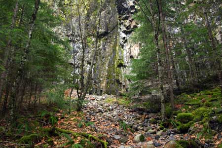
Approaching Warren Creek Falls from the dry streambed

The project could also serve a preventive purpose, since the long-term impact of introducing water to the bypass tunnel may be undermining the stability of the huge cliff face that it passes behind. Already, there are signs of spalling rock on the cliffs near the tunnel, suggesting that the diversion is having an impact on the structural integrity of the cliff. Decommissioning the tunnel could at least arrest this impact.

A section of the long-dry streambed that looks to have flowed yesterday

As fanciful as this project seems to be in a time of tight public budgets, there happens to be a once-in-a-generation opportunity to link the restoration project to a nearby transportation improvement. According to tentative plans for the Historic Columbia River Highway (HCRC) project, the segment of old highway that passes in front of the falls will soon be restored and reopened as a bikeway and pedestrian path, similar to other sections that have been restored over the past two decades.

There is perfect symmetry to linking the waterfall restoration to the reopening of the highway, since it was the highway that led to the demise of the falls. This symbolism is important as a statement of healing and environmental justice. Therefore the project planning should include not only the planners, scientists, architects and engineers needed to design the effort, but also Native Americans representing the countless generations of native peoples who likely visited this spot over the millennia, and perhaps considered it to be of spiritual significance.

The HCRH plan is the key for restoring Warren Creek Falls

How would this work?

How would restoration of Warren Creek Falls work? The first task would be to prepare the dry stream bed for the return of an energetic, flowing stream. Warren Creek is fed year-round by snowmelt from the high slopes of Mount Defiance, and the dry streambed provides a perfect opportunity to engineer an ideal salmon and steelhead habit.

Next, the crowded thicket of young Douglas fir that has colonized the spray slope of the splash pool, near the falls, would need to be thinned and prepared to grow into a healthy stand, perhaps someday framing the falls.

There is also a fair amount of English ivy in the area (dating back to the roadhouses and homesteads that once dotted the old highway) that must be pulled, and this would make for an ideal volunteer project. Likewise, groups like Trailkeepers of Oregon could design and build the short footpath needed to take visitors from the old highway to the base of the newly restored falls.

Finally, the stream diversion at the top of the falls would need to be dismantled. Blocking the diversion tunnel is straightforward – the tunnel is only about five feet in diameter, and could be filled with natural stone or a manufactured plug. The weir at the top would also be removed, allowing the stream to flow into its natural course, and over the falls.

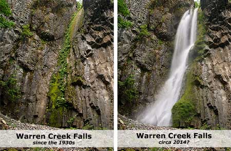
Upon completion of the project, Warren Creek Falls might look something like this:

(click here for a larger view)

What would become of the man-made Hole-in-the-Wall Falls? It would be reduced to a mossy spot on the cliffs, much like Warren Creek Falls is today. But interpretive signage along the adjacent trails could simply point to this curiosity as a symbol of humanity’s hubris, and an earlier time when engineers moved inconvenient waterfalls simply because they could.

This should be an easy project to accomplish, but unlike those bold days of the 1930s, when an engineer could simply decide to move a waterfall, modern times call for more planning and preparation. The HCRH project provides the perfect venue for accomplishing the planning and for funding the project.

However, it will require ODOT to be creative, and involve other state and federal agencies that can help with the project details. But with some ingenuity and dedication, it is quite possible that the falls could be flowing again by 2014, the centennial celebration of Samuel Lancaster’s spectacular road. It’s hard to imagine a better tribute to Lancaster’s original vision than to restore a falls that he specifically had in mind when he designed this section of his elegant highway.

Visiting the falls

It’s fun and interesting to visit the dry Warren Creek Falls. Simply follow I—84 to the Starvation Creek State Park exit, park at the rest area, then follow the trail signs pointing west to the Starvation Ridge Trail. The route briefly follows noisy I-84, then ducks into the trees, following the moss-covered surface of the old highway past Cabin Creek Falls, a tall, wispy cascade framed by house-sized boulders.

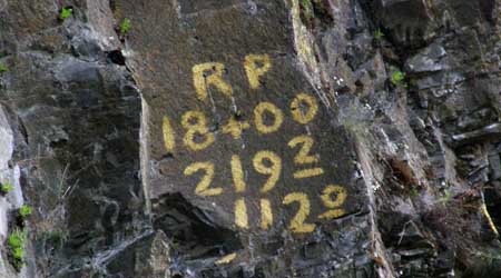
A short distance beyond Cabin Creek, the route becomes a forest trail, soon arriving at the bridge over Warren Creek at the half-mile mark, at the base of Hole-in-the-Wall Falls. Look to the left before crossing the bridge, and you will see the dry former stream bed of Warren Creek coming around a bend. Simply follow the old stream bed for 200 yards to the massive, hauntingly quiet amphitheater of the former falls. Look closely, and you’ll see markings on the cliff that date back to the construction work on the bypass tunnel that passes behind this cliff.

Cliff markings at Warren Creek Falls dating to the construction of the diversion tunnel

You can extend your hike another half mile to Lancaster Falls by continuing over the bridge, then uphill to a T-junction: go right for a short distance to reach the bottom tier of this very tall falls, named for Thomas Lancaster. For still more hiking, you can retrace your steps to the T-junction, then continue about one-half mile east and uphill on the Starvation Ridge Trail to Warren Creek. You’ll pass scenic cliffs and viewpoints along the way, and the bridge-less trail crossing at Warren Creek makes for a pleasant lunch spot.

The New Mount Hood National Recreation Area

When the Omnibus Public Land Management Act of 2009 was signed into law by President Obama last year, most of the media attention focused on the new wilderness lands set aside in Oregon. This included a number of new wilderness areas and expansion of existing areas around Mount Hood and in the Columbia Gorge.

But the legislation also contained a new creature of federal law that hardly noticed: creation of the Mount Hood National Recreation Area (NRA). The new designation joined a number of similar “national recreation areas” on United States Forest Service (USFS) land, and added to the confusion that already exists between USFS areas under this designation, and the completely different National Park Service (NPS) designation of “national recreation area.”

The difference is usually found in the fine print, where commercial logging or other extractive uses are allowed in the USFS version of a “national recreation area”, albeit with limitations, whereas such activities are never permitted under NPS management.

This is true for the new Mount Hood NRA, as well. While the 2009 legislation called for the USFS to “provide for the protection, preservation, and enhancement of recreational, ecological, scenic, cultural, watershed, and fish and wildlife values” in the new recreation area, the Forest Service isn’t quite prohibited from carrying out the activities they’ve come to be known for — timber harvest and road building – unless the NRA overlaps a designated wilderness area.

Timber Harvest – The new law allows the “cutting, sale, or removal of timber within the Mount Hood NRA to the extent necessary to improve the health of the forest in a manner that maximizes the retention of large trees, improves the habitats of threatened, endangered, or sensitive species or maintains or restores the composition and structure of the ecosystem by reducing the risk of uncharacteristic wildfire.”

That’s a mouthful, but it does represent a major departure from the status quo commercial timber harvesting that the USFS has employed over the past sixty years across the Mount Hood region. Simply prioritizing the “retention of large trees” is revolutionary for the agency, since these were the prime targets of thousands of timber sales over the past many decades under the pseudo-science of being “decadent” and “unproductive”.

Road Building – The act states that “no new or temporary roads shall be constructed or reconstructed within the Mount Hood NRA except as necessary to protect the health and safety of individuals in cases of an imminent threat of flood, fire, or any other catastrophic event that, without intervention, would cause the loss of life or property; to conduct environmental cleanup required by the United States; to allow for the exercise of reserved or outstanding rights provided for by a statute or treaty; to prevent irreparable resource damage by an existing road; or to rectify a hazardous road condition.”

Another mouthful, and less of a change for the USFS, since pretty much any new road project could be justified under these criteria. But in reality, the agency has experienced collapsing timber revenues and steep cuts in its operating budgets in recent years to pay for new roads. The road building era of the USFS is over, and the Mount Hood National Forest is among several that going through a process to plan for the closure and decommissioning of unneeded roads to reduce maintenance liability and enhance fish habitat. Nonetheless, the new legislation probably makes it a bit harder to build new roads within the NRA, even if the funds are available.

Bicycles – The act doesn’t come out and say it, but the driving purpose behind the creation of the Mount Hood NRA is to provide new protections against logging and development in areas that not only have a high scenic value, but are also popular with mountain bikers. Because bicycles are not allowed inside wilderness areas (yet), the NRA designation became an important political compromise with bike advocates who initially opposed the legislation for the numerous areas that would become off-limits to bikes.

The implication in this intent is that the areas included in the “national recreation area” will be a priority for developing new bike trails and trailhead facilities, including the conversion of surplus logging roads to bicycle trails in some cases. The act provided no funding for this new programmatic emphasis, however, so the work of building and maintaining bicycle trails in the new “national recreation area” will continue to be an uphill struggle, and require the help of volunteers.

Where is the Mount Hood National Recreation Area?

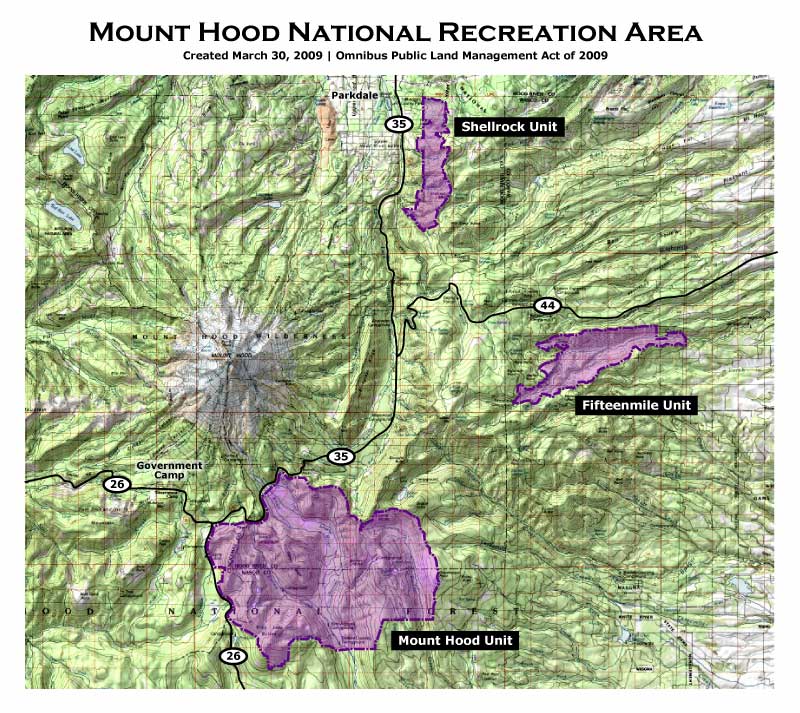
The new Mount Hood NRA covers approximately 34,550 acres in an arc composed of three separate units, each located to the east and south of the mountain. The map below shows the extent and relationship of the three Mount Hood NRA units:

click here for a larger version of the map

The three units of the NRA are located in close proximity to the Mount Hood Loop Highway, and easily accessed from the Portland region, and the communities of Mount Hood and the Gorge. All three are already popular recreation destinations, so the new NRA designation simply embraces and protects this function, while ensuring that cyclists continue to have access.

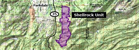
The Shellrock Unit (map below) of the Mount Hood NRA is the smallest and most northern in the complex. This unit is centered on the popular Surveyor’s Ridge trail complex that features miles of some of the finest single-track cycling in Oregon, and has easy access from Forest Roads 44 and 17.

This is also one of the most heavily logged corners of the Mount Hood National Forest, and will require decades of restoration management to recover. However, the extensive network of logging roads also serves as a prime candidate for conversion to single or dual track bicycle trails. This area features some of the finest views of Mount Hood to be found, so the future is bright for recreation in this unit.

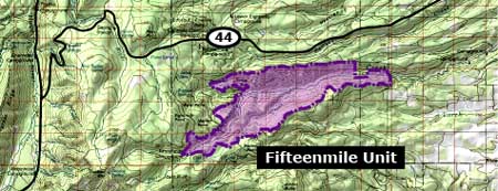
The Fifteenmile Unit (map below) is located due east of Mount Hood, along Forest Road 44, and adjacent to the Badger Creek Wilderness (located to the south). This is also a popular area with cyclists, and like the Shellrock Unit, this area has been brutally logged over the past three decades.

Worse, the remaining forest stands in the Fifteenmile Unit have been hit hard by beetle infestations and drought cycles, resulting in some of the most stressed forests in the Mount Hood region. These conditions, combined with a century or fire suppression where fire is an essential component in the forest ecology has left a tinderbox just waiting for a catastrophic fire.

It will take decades of restoration management to bring back the parkland forests of ponderosa pine, western larch and Oregon white oak that once dominated the area. But as with the Shellrock Unit, the potential for converting logging roads in the Fifteenmile Unit to single and dual track bicycle routes is excellent. The area has a unique blend of high desert and Mount Hood viewpoints that already make it a popular destination, so the NRA designation bodes well for both restoring the forests and expanding recreation here.

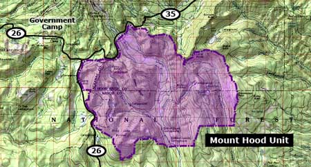
The Mount Hood Unit (map below) is the third and final piece of the Mount Hood NRA complex. This is by far the largest of the three units, extending from the Salmon River on the west to the Badger Creek Wilderness on the east, and encompassing a large segment of the upper White River valley. Unlike the other units, the Mount Hood portion of the NRA complex incorporates new wilderness areas, including the Twin Lakes, Barlow Ridge and Bonney Butte wilderness areas. A segment of the Pacific Crest Trail passes through the west edge of this unit of the NRA.

The range of recreation activities is diverse in this largest of the three NRA units, ranging from heavy winter use by skiers, snowshoers and snowmobiles, and summer use by hikers, equestrians and cyclists. The most popular cycling areas are in the eastern portion, along the Gunsight Trail and in the vicinity of Bonney Meadows and the Boulder Lakes.

The eastern portion of this unit is also the most heavily logged, especially in the southeast corner of the NRA, near Boulder Creek. However, like the Shellrock and Fifteenmile units, the logging road network in the Mount Hood unit provide an excellent opportunity for conversion to single or dual track bicycle routes.

What’s Next?

In the near term, the new Mount Hood NRA functions mostly as a curiosity, though in time it will shape USFS decisions on forest management. The main benefit in the short term is more protection for recreation in these areas, and perhaps expanded opportunities for bicycling.

But in the long term, the designation has an intriguing possibility of serving as a steppingstone to National Park status. For example, it could be eventually expanded to cover a much larger (or all) of the Mount Hood National Forest. This could happen in the near term, as demand for recreation from the rapidly growing Portland area continues to outpace what the Forest Service is able to deliver under its current management approach, and is clearly the preferred public use for the forest.

Thus, if a large portion (or all) of the Mount Hood National Forest were to be designated as an NRA, the step to transferring the area to the National Park Service becomes much more plausible, since the Park Service already administers a number of NRAs under its jurisdiction.

In this way, an obscure, almost accidental element of the Omnibus Public Land Management Act of 2009 might have paved a new way for Mount Hood to finally join the ranks of other national parks.

Mount Hood National Park on Hike Yeah

Yesterday, I had the great pleasure of meeting Alex Head, host of the weekly Hike Yeah program. We recorded a two-part podcast that covers all aspect of the Mount Hood National Park Campaign, and you can stream or download the first 30-minute segment (Podcast 40) from the Hike Yeah website now:

Hike Yeah | Podcast 40 | Mount Hood National Park Campaign

The second segment will air next Friday at 2 PM, and will appear as Podcast 41 on the Hike Yeah website. Alex is a fine interviewer, and had really done his research into the MHNP project before the show, so we were able to jump right in to the questions that people are most curious about: how would National Park management differ from the Forest Service? Would there be additional entry fees? What about my dog..?? Those questions, and many more are covered in the interview.

The second segment airing next week is a bit more expansive, as Alex focused more on things that I’m doing outside the MHNP Campaign, but I did manage to bring it back to the cause I care about most! Alex provides a terrific service with this program, so if you’re a hiker be sure to subscribe and catch his show every week.
______________________________

Edited to add in the link to the second part – rambles onto other subjects like waterfall hunts, restoring old trails and the birth of Trailkeepers of Oregon, but does get back to the main theme of Mount Hood National Park toward the end:

Hike Yeah | Podcast 41 | Mount Hood National Park Campaign

Thanks for the opportunity, Alex – it was fun!

The Mount Hood Quarter

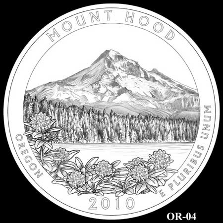
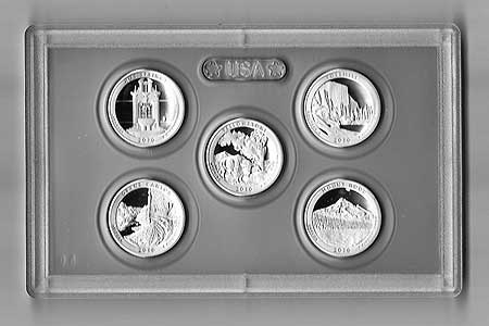
Beginning this year, the new America the Beautiful Quarters program will release the first of 56 new United States quarter coins. The new coins feature national parks and other national sites in each state, the District of Columbia and U.S. Territories. Notably, Mount Hood is one of just two “national sites” in the new set that is not protected by the National Park Service (the other is the White Mountains in New Hampshire).

Still more significant is the timing: Mount Hood will join Yellowstone, Yosemite, the Grand Canyon and Hot Springs National Parks in being the first five coins featured in the inaugural year. This honor is yet another reminder of the mountain’s second-class status among the nation’s natural shrines, but is also more inspiration to correct that oversight. Mount Hood stands in hallowed company in this initial rollout of the new coin series.

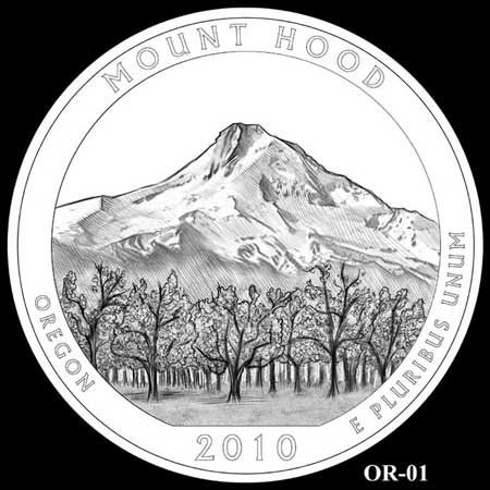
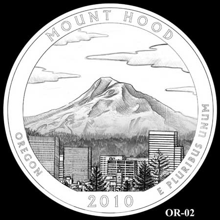
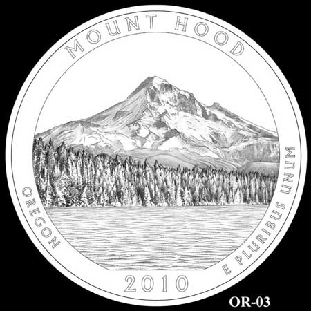
The process for selecting the design of the new Mount Hood quarter is nearly complete. The design has already been narrowed to four options, with one option jointly nominated by a pair of blue-ribbon advisory committee as the preferred design. Secretary of Treasury Timothy Geithner will make the final decision on designs for the first five quarters, and the U.S. Mint will issue the quarters later this year.

The first design option for the Mount Hood quarter features the picturesque view of mountain from the fruit orchards of the upper Hood River Valley. Though it would make a fine choice, this was not the design forwarded by the advisory committees.

The second option is somewhat awkward, since it places the Portland skyline somewhere in the vicinity of Hood River. Thankfully, this option passed over by both advisory committees, and is unlikely to be selected. It’s somewhat baffling how such an iconic view could be botched like this, and we can only hope that the error would have been caught had the design been selected!

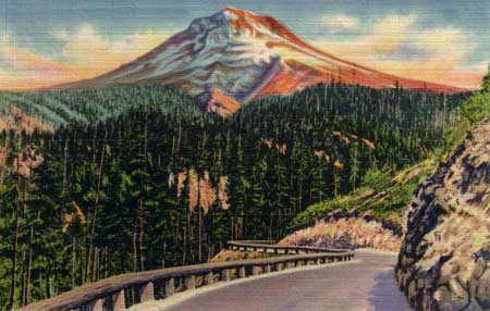
The third option is the familiar and classic view of the mountain from Lost Lake, as seen in a century of countless postcards and other tourist collectables over the decades. This design is the recommended choice of both advisory committees, and seems likely to be the final design.

The fourth option is a variation of the (so far) favored Lost Lake option, adding clusters of Pacific rhododendron blossoms to the foreground. This would have been my pick for the coin, but was passed over by the advisory committees as “too cluttered”.

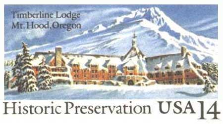
Surprisingly, there were no Mount Hood quarter finalists featuring Timberline Lodge and the familiar south side of the mountain, arguably the best-known view of the mountain. This might be explained by the U.S. Postal Service issuance of a commemorative postcard in 1987 (below) that featured the lodge on its fiftieth anniversary.

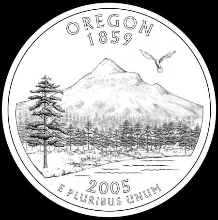
All of this comes on the heels of what was a spirited discussion in 2004, when Mount Hood was one of four designs under consideration for the State Quarters series. This anatomically challenged, clumsy rendering of the mountain was released for public comment on the designs options (along with three other alternatives that featured an Oregon Trail theme, native salmon and Crater Lake):

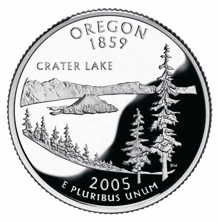
Despite the less-than-inspiring design of the Mount Hood coin in this earlier competition, there was a last-minute flurry of interest in combining the Oregon Trail and Mount Hood themes. After much debate, Governor Ted Kulongoski eventually picked the Crater Lake design (below), and this has now become a favorite among coin collectors.

This earlier choice probably helped move the Mount Hood coin to the front of the line for the America the Beautiful series, though it wasn’t necessarly a given. California, for example, will feature Yosemite on its America the Beautiful quarter, despite having featured the park (and John Muir) on its state quarter. Likewise, Arizona will portray the Grand Canyon on the new quarter, but also featured it on the state quarter series.

So, we’re fortunate that Mount Hood is now getting its due, and will be profiled in such fine company, with more than fifty national parks, monuments and historic sites. It’s an honor well-deserved, and perhaps a foreshadowing of the company that Mount Hood will share in the future.

Addendum

For Mount Hood memorabilia collectors, the 2010 America the Beautiful proof set is here! The following are a couple of scans of the set I received this week. With the set, you will receive the Mount Hood quarter, along with the other four inaugural year quarter — Grand Canyon, Yellowstone, Yosemite and Hot Springs — in this sealed enclosure:

The set comes in this collectable box, with an enclosed certificate of authenticity:

You can order the set direct from the United States Mint.

Proposal: South Fork Water Works Trail

Lower falls on the South Fork Clackamas River in 1963

In 1913, the young cities of Oregon City and West Linn suffered a serious outbreak of typhoid from an increasingly polluted Willamette River, their sole source of water at the time. The incident spurred Oregon City’s leaders to appoint a “Pure Mountain Water League” and directed it to locate a safer source of drinking water.

The League settled on the pristine South Fork of the Clackamas River in the Cascade foothills. The City of West Linn signed on with Oregon City, offering to pay for one third of the cost of a new pipeline to bring the South Fork water to the two cities. A South Fork Water Board was created to carry out this ambitious project.

By the fall of 1915, the new water district had managed to lay twenty-six miles of 18” pipe from a site at the confluence of Memaloose Creek and the South Fork Clackamas all the way to Oregon City and West Linn. The new pipeline began to carry municipal water on October 7, 1915.

Main falls on the South Fork Clackamas River in 1963

In 1939 the South Fork Water Board expanded the system with the help of one of Franklin Roosevelt’s New Deal recovery programs, the Works Project Administration. This project extended a 24” pipeline upstream from the Memaloose Creek intake to a point upstream, above the 120-foot main falls on the South Fork. This project involved carving a series of three dramatic tunnels and a cantilevered pipeline through solid basalt cliffs.

The new intake improved water pressure downstream, and this system continued to serve as the water supply for the two cities until a new filtration plant was constructed on the lower Clackamas River, in 1958. Both systems were used until 1985, when the South Fork pipeline was decommissioned. Since then, the network of roads, tunnels, plank walkways, log bridges and old pipeline has slowly been fading into the green rainforest of the South Fork canyon.

The story might have ended there, except for the series of spectacular series of waterfalls along the South Fork and Memaloose Creek. By the late 1990s, some of the region’s more adventurous kayakers had scouted both streams, and in the early 2000s, had documented the first known descent of the South Fork by kayak.

Main falls on the South Fork with hiker in 1923

These intrepid kayakers portaged the big waterfalls on the South Fork by following the abandoned tunnels and log bridges left behind by the South Fork Water Board. In doing so, they brought renewed interest to the area, as word of a high concentration of waterfalls spread to other adventurers.

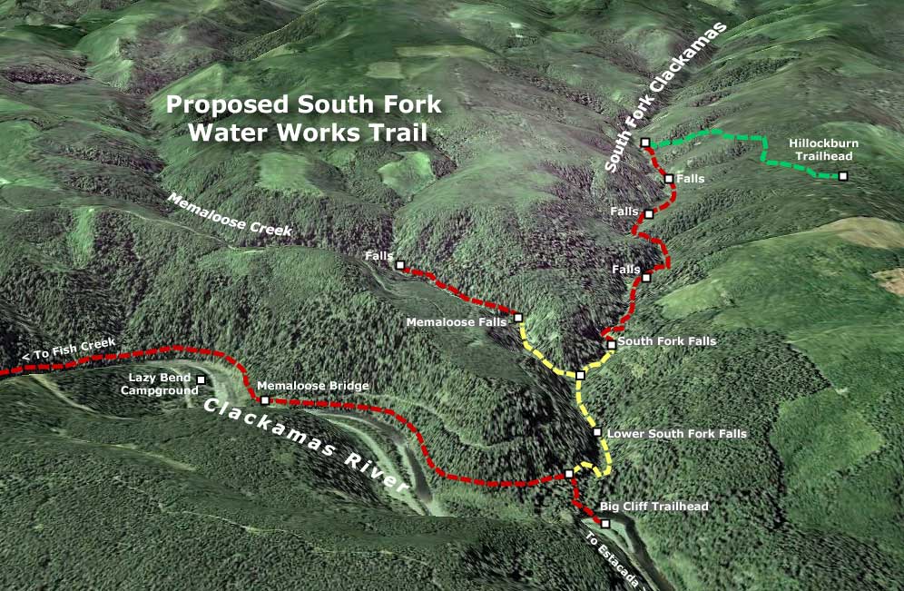
In total, there are five major waterfalls along the final two miles of the South Fork, and two along the last mile of Memaloose Creek, where it flows into the South Fork. The old water works roads and tunnels reach two of the South Fork waterfalls, including the main 120-foot falls, as well as the main falls on Memaloose Creek. The remaining waterfalls are remote, and not reached by the water works roads.

The tunnels and roads along this system are entirely intact and walkable – as several explorers have now documented. A timber bridge over the South Fork at Memaloose Creek is also intact, and is now used by waterfall explorers to cross the stream. These old roads and tunnels offer a unique opportunity for a new trail system that could build on the existing network, and offer an unparalleled blend of natural spectacle, historical artifacts and lots of insight into the history of the South Fork water works project, itself.


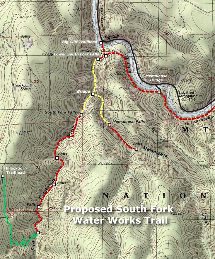
(Click here for a larger map)

What would this trail look like? The accompanying maps (above and below) show the sections that would follow old water works grades in yellow. All of these roads have been recently scouted, and are in good shape, and thus easily converted to trails. The six tunnels along the way (one along Memaloose Creek and five along the South Fork) are also in good shape, and easily walked, although at two are long enough that a headlamp is required.

New trails would also be needed to complete the system, and are shown in red on the accompanying maps. A new trailhead and access trail would located on the east side of the Memaloose Bridge, following the Clackamas River downstream, then turning up the South Fork canyon and joining the converted water works grade at the lower South Fork falls (this section along the Clackamas would also serve as an extension of the Clackamas River Trail, extending east to Fish Creek, and the current trail terminus).

Two trail extensions would carry hikers deeper into the canyons of the South Fork Clackamas and Memaloose Creek, beyond the water works roads. A new Memaloose trail would climb a half-mile to a second falls, upstream from the main Memaloose falls. An extended South Fork trail would continue from the final waterworks tunnel, and travel 1.5 miles upstream along the west bank of the river, passing three remote waterfalls before ending at the existing Hillockburn Trail (shown in green on the maps).


(Click here for a larger map)

Look closely at the maps, and you will also see a proposal to add a trailhead at Big Cliff, along the Clackamas Highway, with a footbridge connecting across the Clackamas River to the new South Fork trail network. The concept here is to provide a family-oriented day-use area on this scenic bend in the river that serves as the long-term gateway to the South Fork canyon. Today, this spot is an eyesore – a huge dirt and gravel expanse that suffers from dumping, shooting and other unlawful behavior. The trailhead and day-use concept would turn this blank expanse into a place for families to explore the river and nearby trails, less than an hour Portland.

Future trailhead and day-use area at Big Cliff?

In deep, rocky canyons like the lower South Fork, building new trails is complex, costly and at odds with modern conservation ethics, where blasting a trail through cliffs is no longer an accepted practice. Thus, the ability to convert the water works roads would bring hikers into a landscape that probably would never be reached with modern trails. In many ways, the canyon is an accidental version of the venerable Eagle Creek Trail, in the Columbia Gorge, where the route is famously carved into the cliffs.

The logistics for this proposal are also fortuitous. The water works area of the lower South Fork canyon was specifically excluded from the 2009 Lewis & Clark wilderness act that set aside the upstream portions of the South Fork canyon as new wilderness. This means that while the upper canyon trail must be built with wilderness restrictions in mind, converting the roads, repairing bridges and preserving the historical artifacts in the lower canyon won’t be encumbered by wilderness restrictions.

This is a project whose time has come – in part, because the word is out about the scenic wonders of this beautiful canyon, but also because the historic features ought to be preserved before they are lost to time and the elements.

Highway 26 Widening Postscript… and Requiem?

Original Loop Highway section on Laurel Hill in the 1920s, later destroyed when the present highway was built in the 1960s

As a postscript to the previous two-part article, I offer some final thoughts on the proposed widening of the Mount Hood Highway in the Laurel Hill area:

First, the Oregon Department of Transportation (ODOT) process used to gather public input on projects like those proposed for Laurel Hill is abysmal. Information on the web is cryptic, at best, and generally absent. Amazingly, there is no opportunity to comment online, nor information on how or where to comment. When I contacted project managers about making comments, I was given different comment deadlines, a full month apart. The ODOT website contains no information on comment deadlines.

ODOT posts a “users guide” to the State Transportation Improvement Program (STIP) process used for funding decisions, but this document manages to be more cryptic than the draft STIP document, itself, since it has been written for government workers and program insiders, not citizens. The process is also designed to buffer the Oregon Transportation Commission from public comment, with any input that does make it to the ODOT region offices collected and processed in a way that effectively buries public concerns under official recommendations by ODOT managers and obscure “citizen” commissions called ACTs. Since there is no ACT for the Mount Hood area, the comment opportunities for the Laurel Hill proposals fall into an even murkier void. In the end, this is a process that is staff-driven, and out of step with the ethic of citizen-centered transportation planning.

Second, the STIP selection process is a done deal by the time most citizens see it, since projects emerge from within the ODOT bureaucracy, not through an open solicitation of public ideas and needs, or even a long-range plan that maps out a pool of projects to draw from.

Thus, the projects in the Laurel Hill area will be very difficult to stop, since they surfaced in the past STIP cycle, and are now about to be funded in 2010 and 2011 as a “routine” final step. Since citizens are discouraged from participation in the selection phase of project funding, these projects will likely advance to a design and construction phase that makes them inevitable before any real public outreach or discourse can really occur. This was the case in the previous “widening for safety” projects in the Wildwood area, where the broader public outreach to citizens in the adjacent corridor began long after the project was conceived and funded. This left area residents with a Hobson’s choice between various widening options for “safety” as opposed to real choices for improving safety that could have been less costly and destructive.

Loop highway construction in the Brightwood area in the 1930s

Third, it is time for the Oregon Transportation Commission to pull the plug on the notion of “widening for safety”. This is a dubious loophole in the funding process the OTC sets forth for project selection, where safety benefits generally bring projects to the top of the list.

That’s a laudable goal, but it allows widening projects cloaked under the “safety” mantle to advance, unquestioned, and become the first to be funded. But as the Wildwood project details admitted, these projects are mostly about “matching the cross-section” of previously widened highway sections in the vicinity, not safety. So, this is nothing more than an highway capacity agenda, and it should be openly considered as such, not slipped under the radar of the OTC.

The stakes are much higher for the Laurel Hill “widening for safety” projects. While future generations may choose to tear up the asphalt and replant the forests that were cut away to make room for a wider highway in the Wildwood and Rhododendron sections, the Laurel Hill projects will require ODOT to blast away more of Laurel Hill’s rocky face. These changes are permanent and destructive, and it would take centuries for the area to recover, should our children or grandchildren conclude that we made a grave error in judgement in an our efforts to save skiers a few minutes driving time. The decision ought to be considered carefully in this light, not slipped through without public discussion.

Simpler days: the original loop highway corkscrewed up Laurel Hill, molding to the terrain as it climbed the steep slopes made infamous by Oregon pioneers

It is also true that ODOT has the means for a very open discussion about the projects proposed on Highway 26, and could give the OTC a true sense of public support for these proposals. For example, ODOT could simply post signs along the highway advertising the projects, and direct interested citizens to an online opportunity to comment. The agency could even use the giant electronic message sign in Rhododendron for this purpose, if meaningful public involvement were truly the objective.

I submit these critiques as one who works in the transportation planning realm daily, so it is both frustrating and discouraging to imagine what an ordinary citizen would have to overcome to be heard in this process. It is a fact that transportation planning is an arcane and difficult to understand realm, and for this reason, Federal Highway Administration (FHWA) regulators are looking for more meaningful public involvement in transportation decisions at the state and local levels. The ODOT processes fall far short of what the FHWA envisions, where ordinary citizens could easily access information about projects that affect them, and make meaningful comment to decision makers.

To meet its regulatory expectations from the federal government, and its obligation to Oregon citizens who fund the very existence of ODOT, it is time for the agency to engage the public in a more meaningful way, and allow each of us to weigh in on how our tax dollars will be spent. The looming decisions about the Mount Hood Highway would be a good starting point for this needed reform.
_________________________________________

Download a copy of the Mount Hood National Park Campaign (PDF) comments on the Highway 26 projects: click here

Download a slide presentation of the 2009 safety audit (PDF) of the Laurel Hill section of Highway 26: click here

Highway 26 Widening Projects – Part Two

The Oregon Department of Transportation (ODOT) is set to begin construction of more than $27 million in road widening projects along the Mount Hood Highway in 2010 and 2011. These projects are supposed to improve safety along the segment of Highway 26 located east of Rhododendron, and along the Laurel Hill grade. In reality, they will do little more than speed up traffic, and perhaps even make the highway less safe as a result.

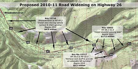
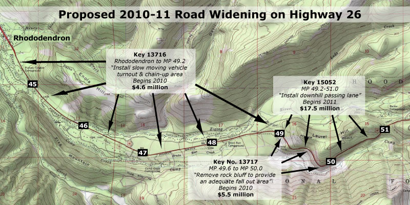
There are a total of three projects proposed for the Mount Hood corridor in this round of funding, including two “safety” projects that would widen the highway, and a third “operations” project that appears to be driven by the other two “widening for safety” proposals. The projects and their ODOT key numbers are shown on the map below.

Three projects are proposed for Highway 26 in 2010-11 that will add capacity to the road, though only if you read the fine print

(click here for a larger map)

The most alarming of the projects in this round of road widening is a proposed downhill passing lane on Laurel Hill, supposedly making it “safer” for throngs of Portland-bound skiers to pass slow vehicles on the downhill grade on busy weekends. This project is a repeat of the outmoded “widening for safety” philosophy that has already impacted the lower sections of the corridor, and was described in Part One of this article.

The ODOT project details for the “downhill passing lane” are sketchy, but such projects generally assume that drivers forced to follow slow vehicles become frustrated, and attempt to pass in an unsafe manner — a potentially deadly decision on a winding, steep mountain road. But is the answer to build a wider, faster road? Or should ODOT first use all of the other tools available to manage the brief periods of peak ski traffic before spending millions to cut a wider road into the side of Laurel Hill?

The answer to these questions seem obvious, but in fact, ODOT is moving forward with the most expensive, environmentally destructive options first, in the name of safety.

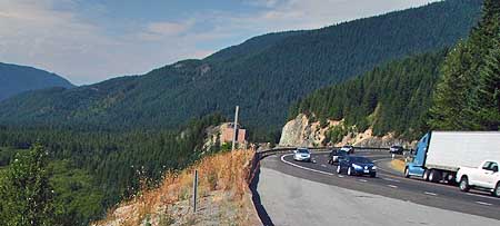
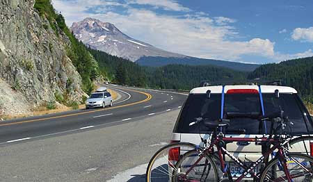
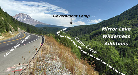
The westward view of the Laurel Hill Grade in a section proposed for widening to allow a downhill passing lane. The newly protected wilderness of the Camp Creek valley spreads out to the left.

A better solution, at least in the interim, would be to employ some of the less-expensive, less environmentally degrading approaches that have been successfully used elsewhere in the corridor. One option could be simply enforcing the current 55 mph speed limit and no-passing zones, for example, which would be much more affordable than the millions proposed to widen the highway in this difficult terrain.

Another possibility could be to extend — and enforce — the 45 mph safety corridor speed limit east from Rhododendron to the Timberline Junction, in Government Camp. Enforcing this slower 45 mph limit would result in skiers spending only an additional 90 seconds traveling the nine-mile section of Highway 26 from Government Camp to Rhododendron. This would seem a reasonable trade-off in the name of safety, especially compared to the millions it would cost to build downhill passing lanes on this mountainous section of highway.

The view east (in the opposite direction of the previous photo) where road widening is proposed to add a fourth downhill lane, carved from the sheer side of Laurel Hill.

Delaying the current road-widening proposals and taking a less costly approach to improving safety would also allow ODOT to more fully evaluate the effects that growing traffic on Highway 26 is having on the surrounding area. And while it is true that delaying a project that has already moved this far in the ODOT funding pipeline is an uphill battle, it is also true that a more fiscally conservative approach is clearly more consistent with the agency’s own transportation policy than the costly widening projects that are proposed.

However, while the visionary Oregon Transportation Plan (OTP) calls for a departure from old school thinking when it comes to new highway capacity, it does not establish a detailed vision for the Mount Hood Highway. But the general direction provided by the OTP does support a least-cost approach to managing highways, and slowing down the latest road widening proposals in the Mount Hood corridor would be consistent with that policy.

Unfortunately, the badly outdated Oregon Highway Plan (OHP) sets the wrong direction for the Mount Hood Highway, emphasizing speed and road capacity over all else. But until a better vision is in place for the highway, the response by ODOT planners and engineers to safety concerns and traffic accidents in this corridor will be more road widening projects sold as “safety improvements.”

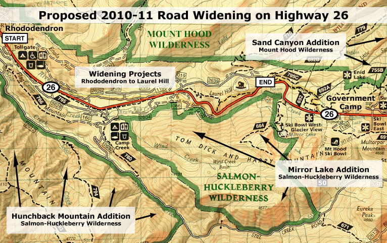
Both the Salmon-Huckleberry and Mount Hood wilderness areas saw major expansions in 2009 that were not considered in the proposed ODOT expansion projects for Highway 26

(click here for a larger map)

Over the years, this old-school approach has already created a road that is rapidly approaching a full-blown freeway in size and noise impacts on surrounding public lands. At the same time, the pressure to minimize highways impacts on the forest surroundings is still growing.

In 2009, wilderness areas around Mount Hood were significantly expanded, and the new boundaries now draw close to the highway along the Laurel Hill grade, where the “safety” widening is proposed. What will the noise impacts of the proposed highway expansion be on the new wilderness?

Already, highway noise dominates the popular Tom Dick and Harry Mountain trail inside the new wilderness, for example, more than a mile to the south and 1,500 feet above the Laurel Hill Grade. How much more noise is acceptable? How will hikers destined for these trails safely use roadside trailheads to access wilderness areas?

Nearby Camp Creek should be a pristine mountain stream, but instead carries trash and tires from the Mount Hood Highway. While it is protected by wilderness now, how will storm water runoff from an even wider highway be mitigated to avoid further degradation? How will existing pollution impacts be addressed?

The answers to these questions were not considered when this new round of “widening for safety” projects were proposed, but should be addressed before projects of this scale move to construction.

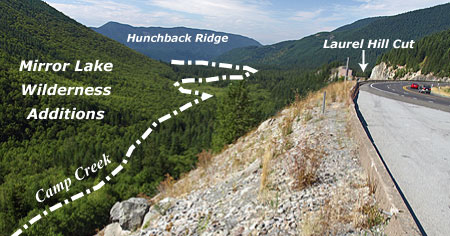
This view west along the Laurel Hill Grade shows the proximity of the new Mirror Lake wilderness additions to the highway project area.

This view east along the Laurel Hill Grade, toward Mount Hood, shows the proximity of the new wilderness boundary to the project area.

In the long term, the solution to balancing highway travel needs with protection of the natural resources and local communities along the Mount Hood corridor needs a more visionary plan to better guide ODOT decisions. Such a plan could establish an alternative vision for the Mount Hood Highway that truly stands the test of time, where the highway, itself, becomes a physical asset treasured by those who live and recreate on the mountain. This should be the core principle of the new vision.

The very complexities and competing demands of the Mount Hood corridor make it a perfect pilot for such a plan — one that would help forge a new framework for managing the highway in a sustainable way that protects both community and environmental resources.

There is also room for optimism that ODOT can achieve a more visionary direction for the corridor. The agency is showing increasing sensitivity to the way in which transportation projects affect their surroundings, as evidenced by in recent projects in the Columbia Gorge and even on Mount Hood.

To underscore this point, I chose the logo at the top of this article because it shows a re-emerging side of ODOT that understands both the historic legacy and the need for a new vision for the Mount Hood Highway that keeps the road scenic and special. After all, Oregon’s highway tradition that includes the legacy of the Historic Columbia River Highway, the Oregon Coast Highway and the amazing state park and wayside system was largely developed as an extension of our early highways. ODOT can do this simply be reclaiming what is already the agency’s pioneering legacy..

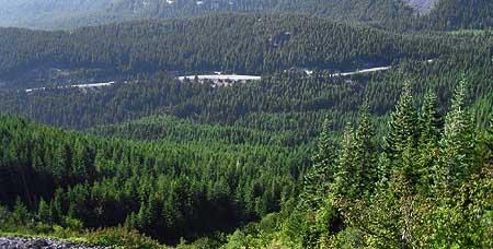
The Laurel Hill Grade on Highway 26 as viewed from a popular trail in the new Mirror Lake additions to the Salmon Huckleberry Wilderness.

The missing piece is direction from the Oregon Transportation Commission (OTC) to develop a new vision that governs how the highway is managed, and establishes desired community and environmental outcomes by which highway decisions are measured. But until a new vision for the Mount Hood Highway is in place, it makes sense to slow down the current slate of costly projects that threaten to permanently scar the landscape, and take the necessary time to develop a better plan.

If you care about the Mount Hood Highway, you should make your thoughts known on both points, and the sooner the better. The process used by ODOT to make these decisions is difficult for citizens to understand and track, especially online. So, the easiest option for weighing in is to simply send your comments in the form of an e-mail to all three tiers in the decision-making structure, using the contact information that follows.

Comments to ODOT are due by January 31, but you also can comment to the Clackamas County Commission and OTC at the same time. Contact information can be found on these links:

ODOT Region 1
(Select one of the Region 1 coordinators listed)

Clackamas County Commission

Oregon Transportation Commission (OTC)

When describing the projects, you should use the “key numbers” shown in the first map, above, as well as the project names. Simply state your concerns in your own words, but consider these critical points:

  1. The proposed Mount Hood Highway widening projects should be delayed until less-expensive, less irreversible solutions can be explored;
  2. The Mount Hood Highway needs a new vision and a better plan

Remember, these are your tax dollars being spent and your public lands at stake. You have a right to be heard, and for your voice to have an impact. With any luck, these projects can be delayed, and more enlightened approaches explored for managing our highway.

Highway 26 Widening – Part One

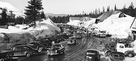
The Mount Hood Highway in the late 1950s, when it was a 2-lane scenic byway that curved through Government Camp on its famous circuit around the mountain.

Several years ago, the Oregon Department of Transportation (ODOT) began a series of safety projects in the Mount Hood Highway (Highway 26) corridor in response to a growing number of deadly highway accidents. So far, the projects are a mixed bag, with some of the projects dramatically widening the highway in an unfortunate attempt to make it “safer”. In making the decisions, ODOT is continuing to follow a path that is gradually transforming the Mount Hood Highway into something that looks more like an urban freeway, one dubious “safety” expansion project at a time.

This recent work went into high gear when Highway 26 was designated a safety corridor by the Oregon Transportation Commission (OTC), which has the effect of doubling fines for speeding and other traffic infractions. While this simple change in fines may be having an effect on driver behavior, the more aggressive action of setting (and enforcing) a new 45 mph speed limit on a portion of the corridor from Wildwood to Rhododendron has clearly been successful in bringing down speeds along this problematic corridor.

Other projects, like the cable median dividers installed on the Cherryville Hill section of the highway, are simple, inexpensive retrofits to the existing road that leave the corridor mostly untouched. These projects provide a significant improvement in safety, according to early reports (view PDF), while leaving the community character and forested highway shoulders intact.

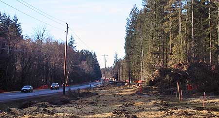
Recent road widening projects along Highway 26 has been sold as safety improvements, but are more likely to simply encourage more speeding.

But on other safety projects in Mount Hood Highway corridor, ODOT has fallen into the old-school highway engineering trap of widening and adding lanes in the name of “safety”. The traditional thinking behind this approach is that making roads wider and adding new lanes will allow faster traffic to pass slow vehicles more safety, and to have better driver visibility and response time, thus reducing accidents.

But this traditional approach is rapidly falling out of favor, as transportation research continues to show that drivers simply drive faster with wider roads and more lanes. A truism is that on highways, speed kills, so widening a highway for safety is a contradiction, since the wider road will simply encourage more speeding and likely produce still more deadly crashes.

The “widen for safety” approach can also have profound effects on the natural environment and health and safety of communities along a corridor. Building oversized roads in rural areas brings an array of environmental and local community impacts that are rarely considered in the transportation decision-making. For example, wider roads not only require more right-of-way to be clear for new lanes, but engineers typically clear forests well beyond the roadway in such projects, justifying wide shoulders with safety and maintenance concerns, but rarely considering options that would leave roadside forests intact.

Faster speeds also have a number of unintended effects on rural communities. The immediate impact is to make it more dangerous for local traffic to enter or cross the wider highway that doubles as their main thoroughfare. Often, historic local access points are eliminated completely in the name of safety. And studies on Washington’s Snoqualamie Pass Highway also show that speeding up traffic results in drivers feeling less safe in pulling off the highway to patronize rural businesses, thereby directly affecting rural tourism economies.

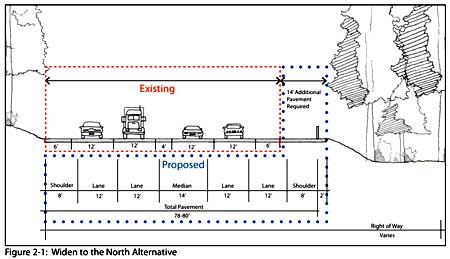
ODOT cross-section of the now constructed Wildwood to Wemme safety widening that eliminated the A.J. Dwyer Scenic Area (2007).

One of the recent projects of this sort was built between Wildwood and Wemme, where scores of trees were cut in a wide swath along the highway to add road width for “safety”. Yet, the project forever altered what the traveling public had assumed was a protected corridor, thanks to a rustic “A.J. Dwyer Scenic Area” sign that had stood for decades on the highway shoulder. As it turned out, the Dwyer preserve never had a chance in the face of a major highway project presented as a “safety improvement.”

The purpose statement in the 2007 ODOT Environmental Assessment for this “safety” project reveals the underlying highway expansion mindset behind the project — to larger goal was simply to widen the highway to “match” already wide segments abutting this segment:

“The purpose of the proposed project is to improve safety on US 26 between milepost 38.75 and milepost 40.01 and to match the cross section (width of lanes, center turn lane and shoulders) to that of the roadway to the east and west of the proposed project area.”

(Source: US 26: Wildwood-Wemme Revised Environmental Assessment 2007)

Another problematic part of such “safety” projects like the Wildwood to Wemme widening is the manner in which the larger public is excluded from participating. ODOT routinely sends notices to property owners in the vicinity — in this case, several hundred residents of the Wemme community, and holds local community meetings. But public involvement beyond the local community is largely absent, especially for those outside the local area who wish to comment online.

In this example, the local outreach effort drew only three written comments, and three oral comments at a public meeting — with one individual responsible for both a written comment and oral testimony — bringing the total public input to five individuals. Surely, a project of this magnitude and permanence deserved greater review and input from the hundreds of thousands of Oregonians who use this corridor each year, but do not happen to live in the local community.

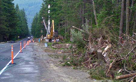
This recent safety project near Zigzag leveled hundreds of trees and converted a scenic 2-lane road into a wide highway.

A similar, recent project built between Zigzag and Rhododendron also destroyed a wide swath of forest (pictured above), and closed traditional access points for local streets in the name of safety. Because a 45 mph speed limit was also established (and enforced) in this section at the same time as the new capacity was added, we will never know if simply enforcing the lower limit might have had the very same safety benefits without the substantial costs and impacts.

One lesson from these recent “widening for safety” projects might be to strictly enforce the “safety corridor” doubling of fines first, or considering applying lower speed limits, to learn whether improved safety can be addressed more simply and cost effectively with simple changes — and with less impact on the environment and community character.

This brings us to the present, and the next round of “safety” projects in the corridor that area about to unfold, a bit further up the highway. These projects are more of the same, but entirely on public lands and in much more difficult terrain. The implication of these projects, and how to have your voice heard, is the focus of Part Two of this article.

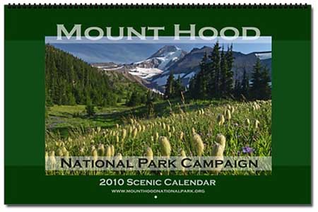
2010 Campaign Calendar

Since founding the Mount Hood National Park Campaign in 2004, I have published an annual scenic calendar that features my best photos of “our next national park” taken during the course of the previous year. While there are familiar spots featured each year, I also include lesser-known scenes, and a number of secret locations that you won’t find in other calendars, and further illustrate why Mount Hood needs more protection.

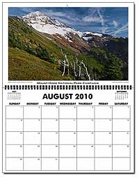
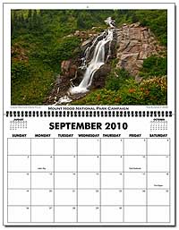
The 2010 calendar features Elk Cove on the cover, photographed early last August on my annual pilgrimage, during the peak of the summer wildflower show. The snowy January scene was captured on a snowshoe trip up the White River last winter. February’s image is also wintry, with a frozen Rock Cove in the foreground, and the snowy, white cliffs on the Oregon side of the Columbia Gorge rising above mists in the background, and catching the last bit of evening light.

The March scene features the first flowers of the season in the eastern Columbia Gorge, at Rowena Crest. Look closely, and you can pick out both a hiker (and fellow photographer) and a grain barge in the river, far below. The town of Lyle, Washington is in the distance. The April scene features a little-known lily pond near Cascade Locks in brilliant shades of vibrant spring green. The May image is another lesser-known spot, the Mazama Tarn. This tranquil pond is located on the northwest side of Mount Hood, and for some reason, rarely photographed.

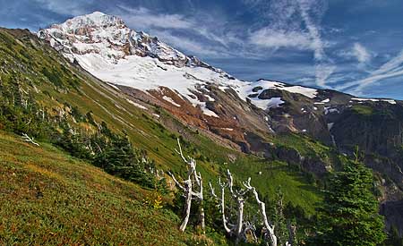
June takes us back to the Columbia Gorge, with a golden-hued sunset as viewed from the bluffs above Mosier. The July and August images are both from the McNeil Point area, first at the reflective McNeil Tarn, then higher up on the shoulder of Mount Hood, near the Sandy Glacier. The August image was captured on perhaps the most magical visit I have made to this beautiful spot over the years, with a mid-summer coat of snow on the mountain and dramatic clouds blowing in, ahead of another storm.

For September, another lesser-known location is pictured — one of several unmapped waterfalls along beautiful Heather Creek, on the southeast shoulder of Mount Hood. Lovely Emerald Falls in the Gorge follows in October, and autumn colors are showing along Gorton Creek in the November scene. The final image for December is a misty morning view of the East Fork Hood River and Mount Hood after a heavy winter snowstorm.

The early Mount Hood National Park calendars were in a smaller format, and thus somewhat forgiving of my photographic efforts. But for the past several years, I’ve used a more popular, oversized 11×17″ format, and the switch has pushed me to assemble a set of images that show off at that larger size. Above all, the images I include are intended to underscore the message: Mount Hood SHOULD be America’s next national park!

You can preview all of the images in the calendar and purchase copies for $24.99 from the Mount Hood National Park store at CafePress. Here’s the link:

MHNP Campaign Store: 2010 Calendar

A portion of each calendar sale goes to the Mount Hood National Park Campaign, and I use all of the proceeds to defray costs of maintaining the website, post office box and other logistics. Thanks to all of you who have purchased them over the years, and supported the campaign in the process!

WyEast Blog: First Year Reflections

Mount Hood on a magical afternoon above McNeil Point last August, one of my photo-trek highlights of the year

November marks the one-year anniversary of the WyEast Blog, so I will indulge with a few reflections on the blog and how I intend to carry it forward as part of the larger Mount Hood National Park Campaign.

The unifying theme is the national park campaign, and blog has, indeed, had a significant impact on traffic at the main website (which was also revamped in late 2008, in tandem with the start-up of the blog). This was the primary objective in starting the blog, so I’m pleased with the response thus far.

For the first several months, I didn’t advertise the blog at all — but it slowly picked up readers as the scope of articles became evident. From the beginning, the blog was designed in a magazine format, with lots of images and topics ranging from science, history and recreation to politics and commentary.

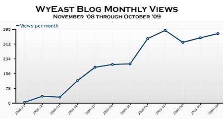
By mid-year, the site was logging about 200 views per month, but in July I posted a link to the site from my PortlandHikers.org signature, and the resulting boost in traffic is evident (see chart, above). The blog has been recording more than 300 views per month since. I was a bit anxious about taking this step, since I have been fairly low-key about the Mount Hood National Park project in my work with Portland Hikers, but the response has been very positive.

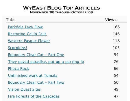
I had planned to write 3-4 articles per month when I started the blog, and have settled closer to three per month, with a total of 34 articles published since the first post. One surprise has been the response to individual articles. There seems to be no rhyme nor reason to the topics that are interesting to others (all of them are interesting to me, naturally!), though the most popular topics are an encouraging mix of natural and cultural history topics and more challenging policy critiques that I didn’t expect to resonate with readers.

The top article on the list was the Parkdale Lava Flow piece, and I admit, this comes as a bit of a surprise. As a geoscientist by training, the lava flow is of great interest to me, but I’m excited to find that others are equally intrigued by this little-known spectacle. That bodes well for its protection, and perhaps even improved public access for adventuresome visitors.

The many visits to the two-part article on the Boundary Clear Cut were also a pleasant surprise, and underscore the ongoing interest in federal forest policy — the Fire Forests of the Cascades article also ranked well in views, for example.

The article that drew the most commentary was a bold call to decommission The Dalles Dam and restore Celilo Falls. The contributors were particularly thoughtful and articulate in sharing their own ideas for realizing this vision, and they reaffirmed my own belief that big ideas are a necessary avenue to achieving environmental reforms and building public consensus for change (and thus the Mount Hood National Park Campaign).

Things to Come

In the coming year, I will continue to publish topical articles related to Mount Hood and the Columbia Gorge, and have at least 50 topics in various states of research and development. My early concern that I would somehow run out of new and interesting topics is no longer, as each article I’ve written has spawned a couple others.

I will also be spotlighting some of the Mount Hood National Park concepts a bit more in the coming year, in the spirit of getting those “big ideas” out there, and stimulating an outside-the-box look at an area we all love and want to protect and restore.

Thanks to all for reading the blog over the past year — thanks for putting up with my periodic typos and run-on sentences, and thanks for the personal comments and encouragement along the way. I’ll do my best to continue to improve the site in the years to come!

Tom Kloster
WyEast Blog

Proposal: Gorton Creek Accessible Trail

GortonCreek01

Emerald Falls on the proposed Gorton Creek Accessible Trail

The Mount Hood National Park Campaign proposes a major expansion of the trail system in the Columbia Gorge and around Mount Hood, including more opportunities for elderly, disabled and young families to experience nature. After all, hiking is the most basic form of active recreation, and should be available to all of us — especially as our region continues to grow and urbanize.

Proposed Gorton Creek Accessible Trail

Accessible trails are designed to provide access for everyone, and these facilities will be in growing demand as our country continues to age. By 2030, nearly a third of our population will be over the age of 55, and accessible trails will be in demand as never before.

In the spirit of providing accessible trails, this proposed new trail at Gorton Creek would allow for easy access to streamside vistas and photogenic Emerald Falls. This section of trail would bring visitors through a lush forest of Douglas fir, bigleaf maple and red alder.

GortonCreek02

Autumn on Gorton Creek as viewed from the proposed location of an accessible viewpoint

Gorton Creek becomes increasingly prominent as the trail draws near the stream and the sound of rushing water fills the air. Just below the proposed viewpoint of Emerald Falls and rushing Gorton Creek, there is a large gravel beach at a bend in the stream that could even provide the potential for universal access to the stream, itself — a first in the region.

The accessible portion of the new trail would largely follow an existing boot path that, in turn, follows a very old roadbed still shown on USGS maps. Thus, the gentle grade that would meet accessible trail design requirements. The dashed yellow line on the map, below, shows where the roadbed segment could be improved to provide universal access to a streamside overlook just below Emerald Falls.

GortonCreek03

Proposed Gorton Creek Family Trail

Family trails are designed to allow young children on foot, in backpacks or in strollers to have their first nature experience, and hopefully begin a lifetime of active recreation in nature.

The second part of the proposed Gorton Creek Trail would be designed for young families, with a short, easy grade leading to a viewing platform below Gorton Creek Falls. The falls is a towering 120 foot plunge set against a magnificent wall of columnar basalt, and would provide an exciting destination for budding young hikers. This section of proposed trail is shown in red on the map, above.

The family trail portion of this project would a couple of important objectives. First, it would provide a new hiking option for families with beginning hikers, with easy access from Portland and the potential to camp at Wyeth Campground as part of the adventure. Such trails are in surprisingly short supply in the Gorge, and therefore often crowded when families are most likely to visit, depriving them of a quality nature experience.

Second, this segment of the trail would combine with the lower, accessible segment to allow for extended family outings — grandparents enjoying the lower streamside viewpoint as young children and parents hike the short family spur to the main falls viewpoint, for example, with the extended family camping or picnicking at the Wyeth Campground.

Gorton Creek Restoration

While this proposal would meet growing needs for accessible trails in the region, it would remedy an escalating problem at Gorton Creek: the secret is out on Gorton Creek Falls, and waterfall enthusiasts are wreaking havoc on the trail-less canyon section above Emerald Falls as they scramble to reach the main falls, upstream. The damage to the canyon slopes (see photos, below) and stream bed is particularly worrisome given the important role the stream has as fish habitat.

GortonCreek04

Gorton Creek Falls is no longer a well-kept secret. Each summer, more visitors are pushing cross-country through the upper canyon, leaving damaged slopes and trampled vegetation in their wake

Finally, trail construction could also allow for the washed-out waterworks at Emerald Falls (see photo, below) to be permanently relocated within the trail corridor, and less prone to the periodic failures that plague the current streamside alignment. The water pipeline is currently in a precarious condition, and would greatly benefit from a trail project happening in this canyon sooner than later.

GortonCreek05

The washed out water supply line for Wyeth Campground hangs from cables anchored to stakes below Emerald Falls

To visit Gorton Creek, drive east of Cascade Locks to the Wyeth exit, turn right, then turn right again on the old highway that parallels I-84. Watch for the Wyeth Campground on the left, just before a bridge over Gorton Creek. If the campground gate is closed, park to the side, and walk through the campground to the well-marked trailhead at the south end — otherwise, you can drive to the trailhead.

To reach Emerald Falls, follow the formal trail 0.1 miles to a junction with Trail No. 400, where it crosses Gorton Creek on an impressive footbridge that kids will want to explore. Continue straight, past the bridge and Trail 400, following the obvious footpath up the east side of the stream canyon for another 0.4 miles. Watch your step around Emerald Falls, as the water works erosion has left abrupt holes and weakened stream banks. Do the canyon a favor, and don’t scramble upstream to Gorton Creek — wait for a trail to be built, instead!

(Editors Note: Trail No. 408 already carries the name “Gorton Creek Trail”, but never comes close to the creek, traversing high above the canyon rim on the shoulder of Nick Eaton Ridge. This trail eventually climbs to the summit of Green Point Mountain — and thus, might be better named the “Green Point Mountain Trail” should a new trail along Gorton Creek become a reality, if not before)

New Maps of Mount Hood and the Gorge

Mount Hood and the Columbia River Gorge were in fine company earlier this year when the National Geographic Society released a pair of new maps in their Trails Illustrated series covering both areas. This map series is generally limited to national parks, so the few outstanding areas outside the National Park System (NPS) included in the set read like a who’s who of places that should be made into national parks or recreation areas.

NatGeo01

For locals already familiar with these areas, the new maps feature surprisingly accurate, up-to-date information on trails, campgrounds, forest roads and — most impressively — the many new and expanded wilderness areas that were legislated this year with the new Mount Hood wilderness bill. This information, alone, makes them a worthy addition to your map collection.

As with any National Geographic map, the cartography is lush, and containes a wealth of details. One example are Bureau of Land Management (BLM) and Oregon State Forest (OSF) lands that are helpfully mapped where they abut national forest boundaries. But most importantly, the new maps show numbered forest trails on a backdrop of contour lines an relief shading, making for an excellent trip planning tool or handy map for the field.

The Mount Hood map (No. 820) extends from Lost Lake south to the edge of the Mount Jefferson Wilderness, and from Table Rock on the west to the Warm Springs reservation on the east. New, expanded boundaries for the Mount Hood, Badger Creek, Bull of the Woods and Salmon Huckleberry Wilderness Areas are shown, and are interesting to study for those who have only seen the new wilderness legislation on cryptic web maps.

NatGeo02

This detail of the Cloud Cap area includes a note about the washed-out Eliot Branch crossing on the Timberline Trail

The Mount Hood map also includes the newly created Clackamas and Roaring River wilderness areas, the new “Mount Hood National Recreation Area” (a new designation adjacent to Badger Creek Wilderness) and the various new additions to the Wild and Scenic River system. Map blurbs provide travel information, area history and surprisingly detailed specifics on each of the wilderness areas that will be valuable to visitors exploring the area.

The Columbia Gorge map (No. 821) extends from Troutdale east all the way to the Deschutes River, encompassing the entire Columbia River Gorge National Scenic Area. The map also extends from Lost Lake on the south well into the Gifford Pinchot country north of the river, incorporating a good portion of the Indian Heaven Wilderness and all of the Silver Star Mountain backcountry.

Like the Mount Hood map, the Gorge map includes trail and travel information, map blurbs with travel information, area history, details on popular destinations within the Gorge and depicts the new wilderness boundaries resulting from the recent Mount Hood wilderness legislation.

NatGeo03

This except from the new Roaring River Wilderness shows the new boundaries in green, and the new Wild and Scenic River designation for the South Fork Roaring River

Both maps are printed on waterproof paper for use in the field, and measure approximately 4.25″ x 9.25″ folded, fitting neatly into a coat pocket or backpack. Both are at a scale of 1:75,000, which is a bit small for some hikers, but has the advantage of being a great travel planning map – or just a nice way to explore those new wilderness areas from the comfort of your traveling armchair. Each map retails for about $12 directly from National Geographic or from online book sellers.

Tiny Timberline Survivors

TinyTimberline00

Bright yellow Sulphur Flower carpet the slopes below Palmer Glacier in August

During the peak of summer in the high country around Mount Hood, hikers flock to the lush mountain meadows in places like Paradise Park, Cairn Basin, Elk Cove and Elk Meadows to take in the huge drifts of waist-deep wildflowers. Along the way, they usually pass through the cinder slopes and glacial moraines that seem barren in comparison, but in fact are home to some of the toughest survivors of the wildflower community.

These diminutive flowers are incredibly rugged, resilient plants that somehow manage to persist in the harshest of alpine environments, cheerfully blooming each August during a snow-free growing season that spans only three or four months. Most are perennials, persisting from summer to summer, despite a thick snow pack for much of the year.

Their tiny size is but one of their adaptations to the extreme conditions that exist above the tree line. Most also feature long taproots that anchor them deep in the loose mountain soil, and thick, leathery leaves that help conserve water while maximizing photosynthesis during the very short growing season.

There are a number of tough species in this community of survivors, but the following are seven that are among the most common and interesting, and worth getting to know. These plants were all photographed on the same August evening, high on the south slopes of Mount Hood.

TinyTimberline01

Creeping Penstemon (Penstemon davidsonii)

Creeping Penstemon
This tiny flower grows just six inches tall, though its woody stems are almost shrub-like, and allow the plants to form carpets several feet across, usually on the protected side of a boulder. The oval, evergreen leaves are small and leathery, and also seem almost shrub-like, resembling tiny rhododendron leaves. The flowers can range in hue from lavender to nearly pink, and bloom in short spikes in early and mid-summer.

TinyTimberline02

Desert Parsley (Lomatium martindalei)

Desert Parsley
This little plant (also called Few-Fruited Desert Parsley) also grows in loose sand or pumice at the tree line, and is anchored by a large taproot that can up to a foot long. The thick roots of wild parsleys were collected by Native Americans as a food. Desert Parsley is most notable for its graceful, fernlike leaves, but also sports bright yellow blossoms in mid-summer. The plant is rarely more than four or five inches high.

TinyTimberline03

Low Mountain Lupine (Lupinus lepidus)

Low Mountain Lupine
This wonderfully tiny lupine is an obvious cousin to its many tall relatives, except that it grows no more than three or four inches tall. The tiny leaflets resemble the large, palmate leaves of larger lupines, except that they are the size of a button. The leaves are also covered in soft, silvery velvet that further helps the plants conserve water. The plants are anchored by a long taproot, like most alpine dwarfs. Their blossoms are globe-shaped, like a clover, though clearly related to the tall flower spikes of their larger cousins. Low Mountain Lupine blooms from early August through early September.

TinyTimberline04

Partridge Foot (Luetkea pectinata)

Partridge Foot
This delicate plant can form an extensive groundcover below timberline, but also blankets moist spots in the harsh country above the tree line, especially where melting snow trickles in small streams across rocky slopes. Partridge Foot is only a few inches tall, with creamy white flower spikes reaching 3-4 inches in mid-summer. The common name comes from the shape if its leaves, which apparently resemble a bird’s foot.

TinyTimberline05

Pussypaws (Spraguea umbellate)

Pussypaws
This tiny wildflower also has a self-evident common name, owing to the soft, fleshy, paw-shaped leaves that help the plant store moisture in its harsh habitat. In mid-summer, Pussypaws are covered with tufts of pom-pom flowers that open white, then fade to rose-pink. These little plants are no more than two inches high, with flower stems reaching three or four inches. It thrives in nearly soil-less pumice, and has an amazing taproot that can be as long as ten feet!

TinyTimberline06

Spreading Phlox (Phlox diffusa)

Spreading Phlox
Easily the lowest alpine flower, Spreading Phlox grow in a mat just 1-3 inches high, with their stunny explosion of cheery blossoms literally covering the plants in early August. The button-like flowers range from white to blue, with all shades of pink and violet between. Like its alpine neighbors, Spreading Phlox is deeply rooted, and thus well adapted to the dry, loose pumice and sandy slopes that it thrives in.

TinyTimberline07

Suphur Flower (Erigonum umbellatum)

Sulphur Flower
Also known as Sulphur Buckwheat, this is a tough survivor that lives in the least hospitable reaches of the alpine environment. This plant has silvery leaves covered with tiny hairs that help conserve moisture, allowing the plants to grow in what seem to be impossible habitats — from cracks between rocks and in loose scrabble on moraines. The flowers can range from cream to yellow, and light up slopes in early summer, before fading to a rosy hue. The top photo in this post shows a colony of Sulpher Flower on Mount Hood’s dry south slopes.

How to See Them
These timberline survivors can be seen all around Mount Hood, and on some of the higher surrounding peaks, too, such as Lookout Mountain and the high spots in the Columbia Gorge that reach above the tree line.

An easy way to see these plants up close is to explore the trails around Timberline Lodge. Several paved footpaths circle the lodge, and head up the mountain from the back of the lodge. You can follow one all the way to Silcox Hut, which is located far above the tree line, but still features many of these tiny flowers along the way.

Another option from Timberline is to follow the Pacific Crest Trail (PCT) south from the lodge, crossing the glacial headwaters of the Salmon River then to an impressive overlook of the White River canyon. This section of the PCT is lined with these tiny alpine survivors. Visit these trails in early August, and you’re guaranteed to see them in bloom.