Latourell Falls Makeover (Part 1)

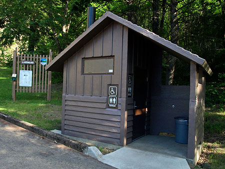
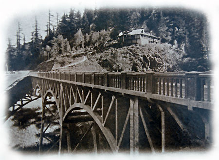
Today’s wayside is located at the east end of the Latourell Bridge, where the Falls Chalet roadhouse once stood in 1914 (shown here)

Today’s wayside is located at the east end of the Latourell Bridge, where the Falls Chalet roadhouse once stood in 1914 (shown here)

Over the past few years, Oregon Parks & Recreation has set the high bar for recreation improvements on the state lands it manages in the Columbia River Gorge Scenic Area. The latest project is a handsome, thoughtful makeover of the Latourell Falls wayside, located along the Historic Columbia River Highway (HCRH) in Talbot State Park.

The Latourell wayside serves thousands of Gorge tourists each year, and also functions as the trailhead for the very popular Latourell Falls loop trail. The site has a long history, and was once home to a pair of roadhouses during the heyday of Samuel Lancaster’s world-class highway in the early 1900s.
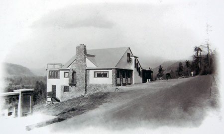
The Falls Villa roadhouse was located across the road from today’s wayside through the 1930s, now marked only by a stand of mature bigleaf maple

The Falls Villa roadhouse was located across the road from today’s wayside through the 1930s, now marked only by a stand of mature bigleaf maple

Modest improvements to the wayside over the years included interpretive historic signs added in the 1990s that tracked the colorful human history of the area, but for the most part, the site was dated and dingy. The restoration work completed last summer is thus a major upgrade that deserves a review here. The work was completed with a special grant secured by the Oregon State Parks department

Makeover Review

Front and center in the rebuilt wayside is the official state park sign, constructed in the standardized style used for both national forest and state park units throughout the Columbia Gorge National Scenic Area (CGNSA). The sign is mounted on a newly constructed basalt base, also designed in the uniform CGNSA style.

Welcome (again) to Guy W. Talbot State Park!

Welcome (again) to Guy W. Talbot State Park!

One missed opportunity in repurposing the existing entry sign was the chance to tell the story of Guy Talbot (picture below, in the early 1930s), one of the business titans of early Portland. Talbot donated the land containing Latourell Falls and the gorgeous canyon above the falls, so deserves more than passing mention in the human story of the area (along with other benefactors who donated the lands we now know as the state parks gems dotting the Historic Columbia River Highway).

Guy W. Talbot as he appeared in 1933 on the front page of the Oregonian, announcing his retirement

Guy W. Talbot as he appeared in 1933 on the front page of the Oregonian, announcing his retirement

Two enamel interpretive panels installed at the wayside in the 1990s were salvaged and reinstalled in the new layout. One focuses on the history of the historic highway (the photos of the roadhouses, above, are from this display) and is now mounted in outside a new restroom (below). It’s a well-trafficked location, albeit sorely lacking in aesthetic appeal! The second interpretive sign is located at the main falls overlook, and briefly describes the history of private land donations for parks in the Gorge.

The new restroom is located at the east end of the wayside, tucked away from most of the picnic tables and a good distance from the new falls overlook plaza. While modern budgets probably require the low-maintenance advantage of pit toilets, the more civilized flush toilets that were removed were an aesthetic notch above the smelly nature of a chemical toilet.
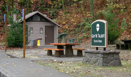
The new restroom is (unfortunately) the standard pit-toilet style found elsewhere along the old highway

The new restroom is (unfortunately) the standard pit-toilet style found elsewhere along the old highway

Considering the volume of visitors to this park, plumbed toilets may be essential — we shall find out soon enough! Fortunately, flush toilets at historic highway waysides still survive at Bridal Veil, Multnomah Falls, Ainsworth State Park, Eagle Creek, Bridge of the Gods and Starvation Creek.

But a major improvement that comes with the new restroom is the location on the south side of the old highway, adjacent to the parking area — the old restroom required crossing the highway. The new toilets are also ADA accessible, along with the drinking fountain located outside the restroom and two of the nearby picnic tables.
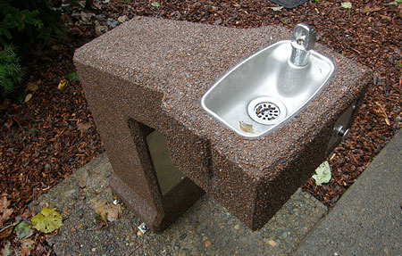
Accessible drinking fountain located outside the restroom

Accessible drinking fountain located outside the restroom

An unexpected benefit from the relocated restrooms: it turns out the old restrooms blocked a very nice view of the Latourell Bridge (below), framed by mossy bigleaf maple trees. The old restroom site is marked only by a flat spot below the highway. The low-headroom trail under the bridge that once accessed the restroom has also been decommissioned.
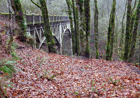
The view that used to be behind the restroom..!

The view that used to be behind the restroom..!

Other details of the new wayside design include basalt curbs that edge the repaved parking area (below), and bicycle racks for cyclists touring the old highway to safely stop and admire the upper viewpoint, fill water bottles, picnic or use the restrooms.
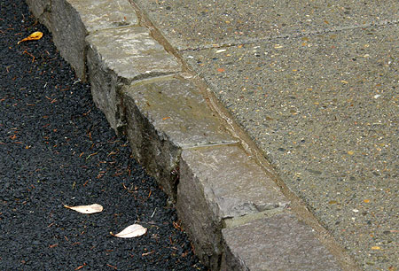
Stone curbs show the attention to details paid by the designers

Stone curbs show the attention to details paid by the designers

One thoughtful aspect of the new bicycle racks is the central location: too often, bicycle parking is relegated to an unused corner. This makes for much less secure parking than a more prominent location, where the public eye is more likely to deter sketchy behavior.
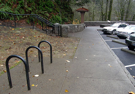
Centrally located bike racks front the main parking area

Centrally located bike racks front the main parking area

The west end of the wayside is the primary focus for visitors, with a handsome plaza and several new visitor amenities. A concrete-capped stone wall in the Gorge style wraps around the plaza, with notched insets for visitor information and interpretive sign installations.

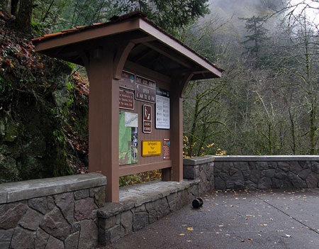
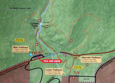
An attractive, new visitor information sign (below) is an excellent addition to the wayside. While it contains the standard park information found at most state parks, an excellent trail map describing the Latourell Creek loop hike is also featured. Even better, the map isn’t of the cartoonish variety often found at tourist waysides. Instead, it shows accurate trail information and even includes elevation contours!
The handsome new visitor information sign at the Latourell wayside

The handsome new visitor information sign at the Latourell wayside

The visitor map does a good job of showing the hiking options and trail highlights, as well as helpful tips on the multiple (and somewhat confusing) trailheads that provide access to the loop. A nice cartographic touch is attention to showing private lands that abut the park (though hopefully some future version of this map will show those lands in public ownership, through the Columbia Gorge Scenic Area acquisition program!)

The excellent, new Latourell Falls Loop map

The excellent, new Latourell Falls Loop map

One minor map glitch exists: the labeling of “Upper Falls” and “Lower Falls” may work for most people, but using the proper place name for Latourell Falls (instead of “Lower Falls”) would be more accurate and informative to those visiting the park for the first time (the upper falls is known unofficially as “Upper Latourell Falls”, so not an issue). There’s rarely a good reason to deviate from official geographic names on maps, after all.
A closer look at the excellent detail on the new park map

A closer look at the excellent detail on the new park map

Hopefully, the State Parks folks will also provide a downloadable, online copy of this map at some point — one that non-profits like Portland Hikers could also offer on their user-created Field Guide, for example.

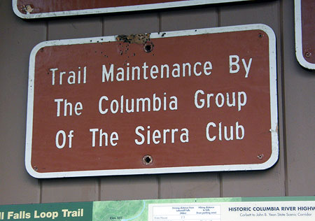
Another nice touch on the visitor information sign is the high-profile shout-out to the Columbia Group of the Sierra Club, the volunteer trail stewards for the Talbot State Park (thanks, Sierra Club!). Not only are the signs a welcome recognition of trail volunteers, but also a subtle tool for raising public awareness to the unfortunate reality that volunteers have become an essential partner to public agencies in keeping our trail system open.
Kudos to the Sierra Club volunteers!

Kudos to the Sierra Club volunteers!

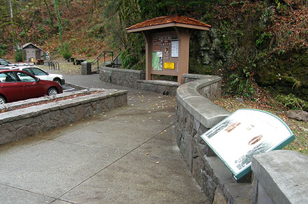
The photo below shows the new visitor information sign from the perspective of the new plaza, with the restrooms visible in the far distance.
The view toward the visitor signboard and steps leading to the upper falls viewpoint from the new plaza (interpretive sign in foreground)

The view toward the visitor signboard and steps leading to the upper falls viewpoint from the new plaza (interpretive sign in foreground)

This view also shows the second notched inset in the curving basalt wall that defines the plaza overlook, where the second refurbished interpretive sign has been installed. This sign briefly describes how Latourell Falls and other nearby parks came into public ownership in the early 1900s, and is the only mention of Guy Talbot in the wayside beyond the entry signs — an oversight that is a missed opportunity in the redesign (more about that coming in Part 2 of this article).
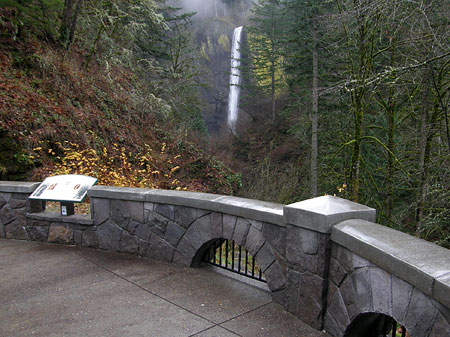
Latourell Falls from the new plaza overlook (with the interpretive sign on the left)

Latourell Falls from the new plaza overlook (with the interpretive sign on the left)

The new plaza corrects many serious problems with the old design, starting with the need for a more spacious falls overlook that respects the historic design of the Samuel Lancaster’s Columbia River Highway. The new plaza meets this test with flying colors, including a subtle, but helpful detail of steps replacing ramps at both the upper and lower loop trailheads.
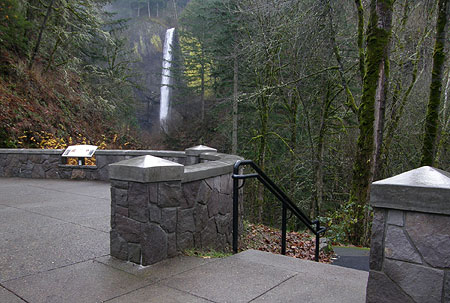
Another view from the plaza showing the interpretive sign (in the distance) and steps leading to the lower end of the Latourell Falls loop

Another view from the plaza showing the interpretive sign (in the distance) and steps leading to the lower end of the Latourell Falls loop

Because the opening segments of the loop in both directions are paved, there has always been a temptation for people with strollers (or worse, wheelchairs) to assume the trail is safe for wheeled vehicles — it is not! Thus, the new steps will help visitors with strollers and mobility devices to avoid the dangerous mistake of venturing onto the loop trail.

The plaza forms a semi-circle in order to incorporate a second view of the spectacular Latourell Bridge in addition to the falls view. This is an unexpected discovery for visitors arriving over the bridge, unaware of its soaring height and graceful arches.
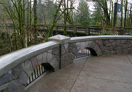
Wayside details: Samuel Lancaster would approve!

Wayside details: Samuel Lancaster would approve!

On this detail, the designers hit a home run, with a series of arches built into the basalt walls that beautifully echo the bridge design, and seamlessly tie the wayside into the highway, itself, as a natural extension of Samuel Lancaster’s masterpiece. Each arch also includes a painted steel grate – a nice detail that will keep kids and pets on the plaza-side of the stone walls.

A newly installed, arch-back bench at the head of the lower loop trailhead gives a similar nod to the historic bridge, while also helping terminate the decommissioned path that once accessed the old restroom, via a narrow, sketchy path that ducked beneath the bridge (the wood post rails in the photo below block the route of the old path).
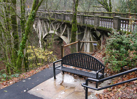
This stately bench salutes the old highway bridge, a nice touch!

This stately bench salutes the old highway bridge, a nice touch!

In the center of the new plaza, the designers have incorporated a long planter-bench (below) that will be a welcome respite for visitors to sit and enjoy the view. However, the design of the bench planter is problematic: The narrow planting compartment is not irrigated, and thus presents a tough landscape dilemma. The designers planted mahonia nervosa, or longleaf Oregon grape that should be drought-tolerant enough to survive, and compact enough to fit the narrow space. But it will also a prickly companion to share the bench with! Perhaps this was intentional (as a means to keep the plants from being crushed)?

The other dilemma with planters of this type is the frustrating reality that it will become an oversized ashtray over time. In the end, it might have made more sense to simply design a wide bench with a solid top for the plaza (which is certainly an option for retrofitting this bench, as needed).
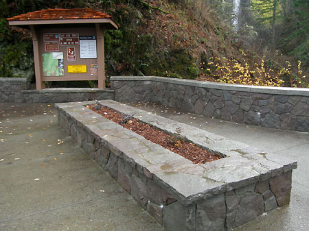
A large planter bench anchors the new plaza

A large planter bench anchors the new plaza

The revamped wayside also includes improvements to the popular upper viewpoint, located just east of the visitor information sign. The upper viewpoint path is also the trailhead for the upper portion of the Latourell Falls loop.

The stairway to the upper viewpoint path (below) also forms the terminus of the stone wall that defines around the plaza, and is nicely designed to simply lead wandering visitors to the overlook. Like the steps at the opposite end of the plaza that lead to the lower trail, these steps may help deter wheelchairs and strollers from the steep, unsafe climb to the upper viewpoint.
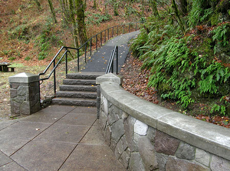
New steps leading to the upper falls viewpoint and loop trail

New steps leading to the upper falls viewpoint and loop trail

Unfortunately, the upper viewpoint path is one of the disappointments in the Latourell makeover. The short, existing section of paved trail to the viewpoint is steep and slick even for able-bodied hikers. Worse, it becomes a terrifying skating rink in winter ice conditions — which happens to be a time when the Gorge is often crowded with visitors admiring the spectacle of waterfalls transformed into ice cathedrals.

While the new handrails help, a home-run design here would have been a series of steps and landings all the way to the viewpoint — picture a scaled down version of the stairs approaching the lower Multnomah Falls viewpoint as an example. Instead, the improved steps at the base of the path taper onto the old path in a fairly awkward transition, an understandable budget constraint, no doubt, but a missed opportunity, nonetheless.
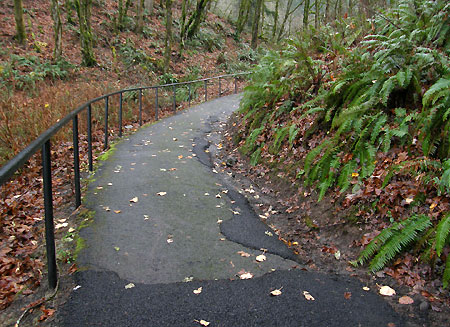
Unfortunately, this ugly, occasionally dangerous path remains a sore thumb…

Unfortunately, this ugly, occasionally dangerous path remains a sore thumb…

After walking the brief section of old paving, visitors suddenly reach a completely reconstructed upper falls viewpoint (below) with nice attention paid to views. The basalt surround at the viewing platform has a subtle cutout where a steel fence allows the falls to be more fully viewed when approaching the overlook. This design replaces an old stone wall that once blocked the view from the trail, so is an especially thoughtful detail.
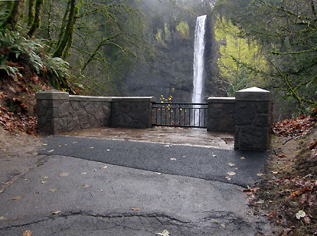
The revamped upper viewpoint platform is a major upgrade, albeit marred by the ugly approach on a steep, outmoded old trail

The revamped upper viewpoint platform is a major upgrade, albeit marred by the ugly approach on a steep, outmoded old trail

The awkward transition from the ugly remnant section of the old pathway to the new platform detracts from the otherwise beautiful scene, but is also something that can be remedied with future enhancement to the viewpoint.
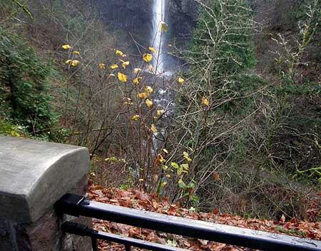
The disappearing Latourell Falls view: a thorny problem?

The disappearing Latourell Falls view: a thorny problem?

Some unfinished business exists at the upper viewpoint, and it might fit into the State Parks operations budget: any photographer will attest to some much-needed “view management” here. Over the past decade or two, the brushy slope below the viewpoint (below) has swallowed up the bottom third of the falls. It’s something that a bit of pruning would greatly enhance. As recently as the 1990s the splash pool at the base of Latourell Falls was clearly visible from the viewpoint.

A Legacy Achievement

Though there will always more work to do in bringing the Gorge trails and byways closer to the national park standard, the Latourell Falls makeover is a terrific step in that direction. The project achieves a level of quality and permanence that few improvements manage.
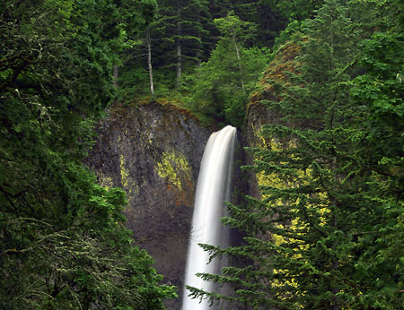
Latourell Falls from the new wayside plaza

Latourell Falls from the new wayside plaza

The new space created and constructed by the State Parks team will easily last for decades, joining the rest of the historic Columbia River Highway as a stunning blend of nature and architecture that continue to thrill visitors from around the world. It’s truly a legacy project, and all who were involved in the design and construction deserve our kudos – thank you!
______________________________

(Next up in the Part 2 of this article: a look at the Latourell Loop trail and possible improvements that would bring this popular trail to its full potential)
______________________________

Read an article on the Latourell wayside makeover

Read an article on the local stone masons uniquely skilled to do the kind of work on display at Latourell Falls

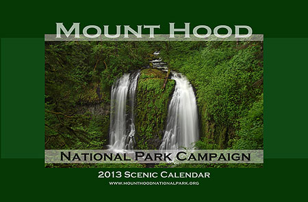
2013 Mount Hood National Park Calendar

Each year at about this time I assemble the Mount Hood National Park Scenic Calendar. The proceeds are modest, but do help support the Mount Hood National Park Campaign website, WyEast Blog and related project expenses. But the main purpose is to simply promote the national park concept, and make the case for the campaign with pictures.

What the calendar looks like – oversized 11×17” pages you can actually use!

I’ve published the calendars since 2004, so this year’s calendar marks the ninth edition. All of the photos in the calendar are from trips and trails I’ve explored over the past year. I get a surprising number of questions about the photos, so in addition to simply announcing the 2013 calendar, this article tells a bit of the story behind the new images — and some are surprising!

The 2013 Scenes

The cover image for the 2013 calendar is Upper McCord Creek Falls, located just west of Cascade Locks. This is a popular destination for Columbia Gorge lovers, though often overshadowed by its more famous downstream sibling, Elowah Falls.

Cover Scene: Upper McCord Creek Falls

Upper McCord Falls is unique in that it flows as a twin cascade. A little known fact is that a third segment used to flow during the rainy season as recently as the 1970s, just to the left of the two segments shown in the photo (above). The third segment has since been blocked by stream debris, however, so for now, Upper McCord is best known as a twin cascade.

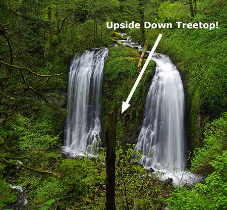
The falls is popular with photographers, but in 2010 was briefly obstructed by a large treetop that had split from atop a nearby maple, landing perfectly on its head, directly in front of the falls. While the local photography community simply grumped and groaned about this unfortunate development, Gorge waterfall explorer and photographer Zach Forsyth did something about it: he scrambled down the slope, and neatly tipped the 40-foot up-ended tree on its side. Thus, Zach made this year’s calendar cover possible – thanks, Zach!

Upper McCord Creek Falls with “the stump” in 2010

Upper McCord Creek Falls is tucked away in the hidden upper canyon of McCord Creek, just a few hundred yards from the brink of Elowah Falls. The trail to the upper falls is especially spectacular, following a ledge chiseled into sheer cliffs in the early 1900s to pipe water to the former Warrendale Cannery, below (portions of the pipe system can be seen along the trail). The falls is hidden from view until you abruptly arrive at the dramatic overlook, directly in front of the falls – one of the finest and most unexpected scenes in the Gorge.

The January calendar scene is a wintery view of the rugged west face of Mount Hood, just emerging from the clouds after a fresh snowfall. This view was captured just a few weeks ago near Lolo Pass, as the evening light was briefly catching the summit.

January Scene: West face after an early winter storm

Like most “mountain in the mist” images, this one was a reward for patience: I waited for two chilly hours for the clouds to clear! It worth the wait, though I’ve also had my share of disappointments when that glorious glimpse of the mountain didn’t materialize.

For the month of February, I picked an image from a trip last winter along the Little Zigzag River. I had planned to snowshoe to Little Zigzag Falls from the Kiwanis Camp, but there were only about 18 inches of snow on the ground, much of it fluffy and new. So, I simply trudged through leaving some very deep boot prints in my wake — and happily, the only footprints on the trail that afternoon.

February Scene: Little Zigzag River in winter

The weather was extremely cold on this visit, revealing one of the surprising effects of running water in winter: it turns out the sheer volume of relatively “warm” water (that is, above freezing) flowing down the Little Zigzag river actually heats the narrow canyon, much like an old steam radiator heats a room.

Following this radiator analogy, the temperate gradient is most noticeable when air temperatures are really cold. It was about 12º F that day, yet the air right next to the stream, and especially in front of Little Zigzag Falls measured in at a “balmy” 30º F. I found myself peeling off layers while shooting the stream and falls, only to hurriedly put them back on as I ventured back down the trail and into the real cold!

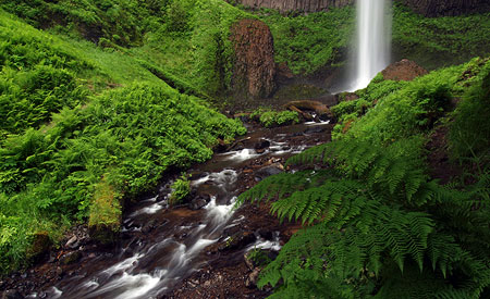
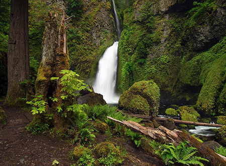
For the month of March I chose another waterfall scene, this time the lush, verdant base of popular Latourell Falls in the Columbia Gorge.

March Scene: Latourell Falls in spring

On this visit to the falls, Oregon State Parks construction crews were starting work on several major upgrades to viewpoints along this busy trail. As a result, the most popular trailhead at the Latourell Wayside was closed. Instead, I took a back route to the falls and had the place to myself for the better part of an hour — nearly unheard of on what should have been a busy spring weekend at Latourell Falls.

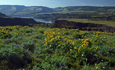
The April calendar scene is from Rowena Plateau at the McCall Preserve, in the dry, eastern Columbia Gorge. The iconic yellow balsamroot and blue lupine were in peak bloom on this sunny afternoon in mid-spring, and the glassy surface of the Columbia River in the background reveals a rare day of calm in the normally windy Gorge. The very tip of Mount Adams peeks over the hills on the horizon, on the Washington side of the river:

April Scene: Balsamroom and lupine on Rowena Plateau

The trip to Rowena was especially memorable for me, as I was hiking with an old college friend who was visiting Oregon for a few days. Rowena was a great place to catch up on news and old memories.

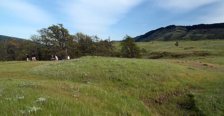
My friend also happens to be an eminent geologist working for the federal government, so we had a great conversation about the mystery of “desert mounds” (also known as “biscuit scablands”), which found on Rowena Plateau and in other areas in the Columbia Basin (watch for a future WyEast Blog article on this subject…).

Hikers passing one of the mysterious desert mounds on Rowena Plateau

Continuing the balsamroot-and-lupine theme, the May scene in the new calendar comes from Hood River Mountain, a tract of private land that is (for now) open to the public, but at risk of closure, due to heavy use by hikers.

This is one piece of land that will hopefully come into public ownership someday, before a less responsible private owner places trophy homes on these beautiful slopes. I wrote about this unfortunate oversight in the Columbia River Gorge Scenic Act in this article from a few years ago.

May Scene: Hood River Mountain in May

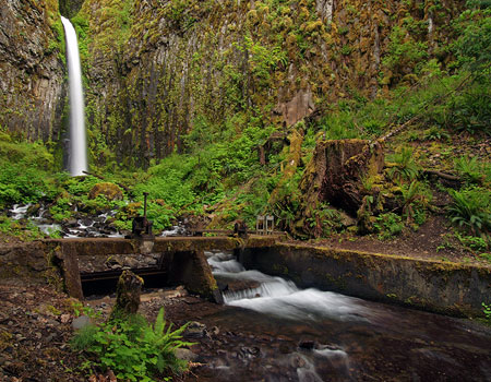
On Memorial Day last spring, I made a trip to Dry Creek Falls, a beautiful waterfall saddled with one of the most unfortunate and uninspiring place names in the Gorge! The June calendar image is from that trip, and captures Dry Creek rambling through the forest a few hundred yards below the falls.

June Scene: (not so) Dry Creek in spring

This area has a unique history: an old, derelict diversion dam and waterworks survives at the base of the falls, where the City of Cascade Locks once tapped the stream for municipal water in decades past. Perhaps this is the origin of “Dry Creek” name — did the stream below the diversion actually go dry when the dam was installed? Perhaps, but today it flows year-round, and makes for a beautiful streamside hike in spring.

Dry Creek Falls and the remains of the old diversion dam and waterworks

The July scene in the 2013 calendar is from a trip to Elk Cove last August. This is one of my annual pilgrimages, and I have photographed this particular spot just east of Cove Creek too many times to count — yet I’m always excited to get there, and recapture the stunning scene.

July Scene: Summer wildflowers at Elk Cove

The wildflower bloom on Mount Hood was delayed by several weeks this year, so even though I was a bit late in visiting Elk Cove, there was still a bumper-crop of purple aster mixing with the blue lupine and mop-heads of western anemone, or Old Man of the Mountain.

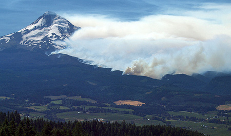
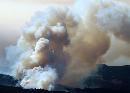
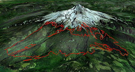
Not visible in the calendar view of Elk Cove are the blackened forests directly behind me: the Dollar Fire of 2011 swept across a 5-mile swath along the northern foot of Mount Hood, charring the northern fringes of Elk Cove, including several large stands of mountain hemlock that frame the view from 99 Ridge.

The Dollar Fire burned a 5-mile swath across the north slope Mount Hood

Though it’s initially shocking to see healthy forests killed by fire, it is also part of the natural cycle of forest renewal. Thus, we’ll now have a front-row seat to the fire recovery process that will unfold over the coming years along the popular north side trails. I wrote this blog article on the Dollar Fire earlier this year.

For the August calendar image, I picked a less familiar scene from an otherwise popular hike: the soaring trail to the 8,514’ summit of Cooper Spur. To beat the crowds, I set my alarm for 3 AM and raced to the trailhead at Cloud Cap. I was the first to arrive at the string of dramatic viewpoints along the trail, and caught the first rays of sun lighting up the northeast face of the mountain.

August Scene: Eliot Glacier from Cooper Spur

This view is from the north shoulder of Cooper Spur, just below the summit, and looking into the impressive jumble of crevasses and icefalls along the Eliot Glacier. Though the sky was crystal clear (you can see the moon setting to the left of the mountain), the winds from the south were strong and blustery. So, getting this shot from the lee side of the spur also meant enjoying some respite from the intense wind and blowing volcanic grit.

For the September image, I selected a lesser-known view of the mountain: the remote and rugged Newton Canyon, on the southeast side, where Mount Hood has a broad, massive profile.

September Scene: Rugged Newton Creek Canyon on the east side of Mount Hood

Glacial Newton Creek is best known for the havoc it brings far below, where the stream has repeatedly washed out Highway 35 with violent debris flows that toss Toyota-size boulders and whole trees across the road in their wake. Construction crews were busy this summer completing yet another repair, this time for damage that occurred in the 2006 floods. As always, the new road is bigger and higher than the old. We’ll see if Newton Creek is persuaded to flow through the new series of larger flood culverts this time…

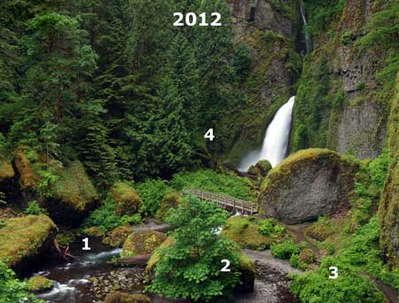
The October scene is from Wahclella Falls on Tanner Creek, a popular family hike that also provides terrific viewing of spawning salmon and steelhead in early autumn.

October Scene: Wahclella Falls in autumn

Fall colors were somewhat muted in 2012, thanks to an unusually long, dry summer that extended well into October. As a result, the broadleaf trees in many areas had already dropped a lot of leaves due to the stress of the drought, before they would even have a change to change with the seasons.

While fall colors at Tanner Creek were less affected by the summer drought, the autumn scene in this year’s calendar has to make due without without the help of the particular tree, the Wahclella Maple I wrote about earlier this year. You can see the hole it left by comparing this year’s image (above) and a 2010 image (below).

Wahclella Falls in 2010 with the Wahclella Maple still standing above the footbridge

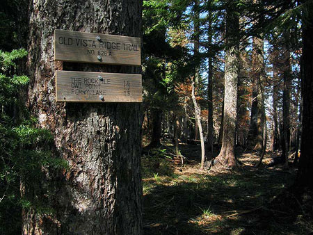
Since 2007, I’ve made annual trips with friends and volunteers to tend to the Old Vista Ridge Trail on the north side of Mount Hood. This historic gem from the early 1900s was an overgrown, forgotten victim of the Forest Service clear-cutting juggernaut for some 40 years, but somehow managed to escape their chainsaws.

Volunteers re-opened the Old Vista Ridge Trail in 2007, spurred in part by a Forest Service scheme to turn the area into a playground for dirt bikes and ATVs — an appalling plan that was eventually abandoned, in part because the rediscovered trail had revealed the beauty of the area to so many.

In 2010, the trail became the official northern boundary of the expanded Mount Hood Wilderness, when President Obama signed a new wilderness bill into law. This change should close the door on future Forest Service threats to the area, and today the hike into one of the best on the mountain.

November Scene: Mount Hood from Owl Point

The November calendar scene is from a viewpoint along the Old Vista Ridge Trail known as Owl Point, the rocky outcrop with stunning views of the mountain. Bright red huckleberries light up the foreground in this scene, and the first dusting of snow highlights the mountain. In the distance, you can also pick out the browned forests on the slopes of Mount Hood, where the Dollar Fire swept across the base of the mountain in 2011.

The final image in the new calendar is another taken from Lolo Pass, perhaps one of the most spectacular views of Mount Hood. This image was taken just before sundown after a fresh snowfall had blanketed the mountain.

December Scene: Winter arrives at Lolo Pass

I paid the price for taking in the sunset that night at Lolo Pass, as my car was broken into at the trailhead – something I’d somehow managed to avoid in all my years of hiking! As frustrating as it was to deal with the repairs and lost belongings… I’d do it all over again just to spend those magical hours watching the mountain that night — it was truly breathtaking! Here, take a closer look, and see for yourself:

Mount Hood from Lolo Pass | 2012
_________________

The thirteen images I chose for the 2013 calendar are from a few thousand images I’ve taken this year on something just shy of 40 outings to Mount Hood and the Gorge — a bit less time on the trail than a typical year would allow, but no complaints! As always, these adventures took me to new places and discoveries, as well as fond visits to my favorite old haunts.

And as always, the magnificent scenery further confirmed my conviction that Mount Hood should (and will!) be set aside as our next National Park! Hopefully, the calendar makes the case, as well.

How can you get one, you ask?

The new calendars are available online:

2013 Mount Hood National Park Calendar at CafePress

They are large and functional, measuring 17” across by 22” tall when hung, with plenty of room for writing notes and scheduling activities. CafePress packages them carefully, with each calendar sealed against a corrugated cardboard backing for support.

The calendars sell for $29.99 + shipping, with about 25% of the proceeds going to support the Mount Hood National Park Campaign. They make terrific stocking stuffers (…although you’ll need an 11×17” stocking…), and CafePress now makes it even easier by offering PayPal as an option.

And as always, thanks for your support!
_______________________________________
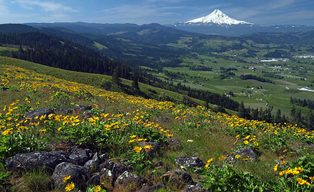
Addendum: Gorge uber-Guru Scott Cook set me straight on a couple of comments in the above article:

Hey Tom, so of course I read your blog like a good Gorge denizen. A couple of points…I’m not trying to sound like a know-it-all…but I know that you do like to get at the bottom of things and eschew conjecture:

The pipes visible on the Upper McCord trail are from Myron Kelly’s pulp mill, not Warren’s cannery. There are some pix on my blog of Kelly’s mill and iterations of his pipes. I have another old pic too showing the pipe running along the cliff cleft, illustrating to me that the cleft was a pipeway instead of a WPA/CCC construction.

2013MHNPCalendar16
(author’s note: here’s a photo I shared with Scott that shows CCC crews clearing out the old waterline shelf to make way for the trail to Upper McCord Falls — note the Historic Columbia River Highway, far below, and the CCC crew bosses in full uniform)

…and, about Dry Creek falls, the Creek was called Dry Creek before the water works were installed. The reason is that just downstream of the PCT trail bridge, just down the access road 200yards, the creek dries up in the summer to nothing, just a dry creek bed as the creek goes subterranean until re-emerging downstream of the powerline corridor.

If you walk down the access road in the summer, the stream is of course flowing under the bridge, but when you walk downstream the sound goes away and you just figure the stream curved away from the road, but nope, if you bushwhack over just 100 feet you’ll see the dry stream…as you will if you continue down the access road also.

Down the (Dry Creek) access road is a bunker-looking building that was built in the 30’s to store the water from the stream’s waterworks for the city’s first municipal supply. The water shed is still in use today, but the water is pumped upwards into it from wells in the town below.

Next edition of Curious I’ll have Dry Creek Falls as a loop using the powerline access road…so people can learn the history and see the Dried-up Creek as well (cuz everyone loves a loop). Look for my pix on Google Earth of all this stuff and the dried-up creek. -Scott

Thanks, Scott!

Warren “Barney” Cooper

Early 1900s map with Warren Creek identified

While tracking down the human history behind the mysterious (and temporarily defunct) falls on Warren Creek in the Columbia River Gorge over the past year, I was surprised to learn that “Warren” is not the surname of a local homesteader or early explorer.

Instead, it is the first name of an early Forest Service ranger, Warren “Barney” Cooper, whose own surname puts him among Mount Hood’s pioneering royalty: the remarkable Coopers of the Hood River Valley.

The David Rose Cooper Family

David Rose and Marion Cooper with their family in 1884. Barney Cooper is on the right (photo: A Complete History of Mount Hood)

Barney Cooper was part of a pioneer family that figures prominently in the history of the Hood River Valley. His father, David Rose Cooper, uprooted from Aberdeenshire, Scotland in 1872 (where the Cooper family had lived for more than 300 years), and moved his wife Marian and their children to settle in America. After a trek across the country, David and Marion Cooper originally settled near Roseburg, in Southern Oregon. Here, they gave birth to several children, including Warren.

In 1882, the Coopers moved again to become some of the first white settlers in the upper Hood River Valley. David Rose Cooper was captivated by Mount Hood, and the idea of building a road to the foot of its enormous north side glaciers. In 1884, he teamed up with two local settlers, Henry Coe and Oscar Stranahan, to form the Mount Hood Trail and Wagon Company.

Under this venture, they built a trail to the mountain, completing work in 1886. The trail was quickly expanded to become a rough wagon road, and in 1888 opened as a 12-mile toll route. The new road led adventurers to the rocky crest on the shoulder of the mountain where the historic Cloud Cap Inn still stands today.

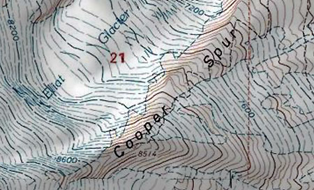
Cooper Spur was named for Warren’s father, David Rose Cooper

The legacy of these early pioneers lives on in our place names. A well-known Mount Hood adventurer from Portland, Dr. Thomas Lamb Eliot, spent time exploring the mountain with the men who built the first road, and named several prominent landmarks on the mountain in their honor: Cooper Spur for David Rose Cooper, Coe Glacier for Henry Coe and Stranahan Ridge and Falls for Oscar Stranahan.

With the new road in place, David Rose Cooper opened a “tent hotel” near today’s Tilly Jane camp in 1888, offering guide services where he led guests across the high country on Mount Hood’s northeast slopes. Marian Cooper and the couple’s younger children all helped in the tent hotel operation, including Warren Cooper, who was just 12 years old at the time. The oldest Cooper children stayed behind, tending the family farm in the valley below.

The Cooper tent hotel near Tilly Jane in 1888 – a young Warren Cooper is atop the horse in the center (photo: A Complete History of Mount Hood)

The modest tent hotel was short-lived. In 1889, a group of Portland investors had begun work on the Cloud Cap Inn, and purchased the Cooper toll road as part of forming a new Mount Hood Stage Company. The new lodge opened in August 1889, ushering in a new era of tourism on the mountain that continues to this day. The seed that started it all was the Cooper family’s tent hotel.

Barney Cooper and the Forest Service

Warren McCalley “Barney” Cooper was born in 1876 in the town of Wilbur, where the Cooper family first settled in Southern Oregon. Time spent on the slopes of Mount Hood after the family moved to the Hood River Valley had a lasting impression on Barney. During the 1890s, he became a forest ranger for the Cascade Forest Preserve, the huge federal holding that preceded formation of the U.S. Forest Service.

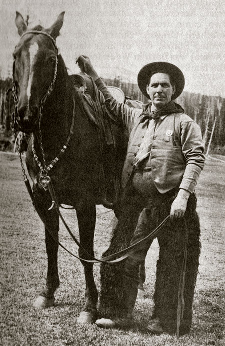
Warren M. “Barney” Cooper at Elk Meadows around 1915

Barney Cooper eventually served as the first district ranger for the Hood River Ranger District with the creation of the U.S. Forest Service in 1905. He served in this capacity for 15 years. During his tenure, the Mount Hood portion of the Cascade Forest Reserve was be set apart in 1908 to become the Oregon National Forest (and was later renamed the Mount Hood National Forest, in 1924).

There was no ranger station at the time, so Barney conducted Hood River Ranger District operations from his home near Parkdale. Duties were initially focused on protecting the forest from timber thieves and squatters, but soon shifted toward fire prevention. During this formative era, many of the familiar names we know in the Mount Hood area were placed on early maps by the first forest rangers, and many of the trails and roads we still use were planned and built.

A scene from the original route to Cloud Cap that David Rose Cooper conceived and built

In 1915, Barney led an expedition of state officials on a preliminary survey of the Mount Hood Loop Highway. Sam Lancaster’s Columbia River Highway was nearing completion in the Gorge, and there was great interest in completing a loop around the mountain. Barney led the group up Cold Spring Creek to Elk Meadows, then down to Hood River Meadows, bypassing the steep East Fork canyon — though the highway would eventually follow the more rugged canyon route.

Barney and Kate Cooper

When Barney Cooper was 28 years old, he married Catherine Elizabeth “Kate” Gribble, who had just turned 25 years old. They were wed on December 28, 1904 in Wasco County, east of Hood River.

In 1907, Barney and Kate lost their first child at birth, a daughter. In 1913, they gave birth to a second child, Wilbur David Cooper, who would live to be 97 years old. He died only recently, on October 28, 2010 in El Cerrito, California. Sadly, both Barney and Kate died in 1920, leaving young Wilbur Cooper an orphan at the age of seven. He was raised by the extended Cooper family living in the Hood River Valley.

Warren McCalley “Barney” Cooper

Barney Cooper’s cause of death is listed as “sleeping sickness”, which might seem odd today, given our familiarity with the tropical version of “sleeping sickness”. But from 1916 to 1926, another form of sleeping sickness — encephalitis lethargica — swept the globe in a widespread epidemic. Barney Cooper died in Portland on February 18, 1920.

Kate Cooper died just a week before Barney, on February 11, 1920. Kate died of “consumption”, or what we know today to be tuberculosis. Kate also died in Portland.

There’s no known history on the sequence of events that sent both Kate and Barney into a Portland hospital at the same time, but it must have been devastating for the extended Cooper family. They were in the prime of their lives, as Kate was just 41, and Barney 44 years old.

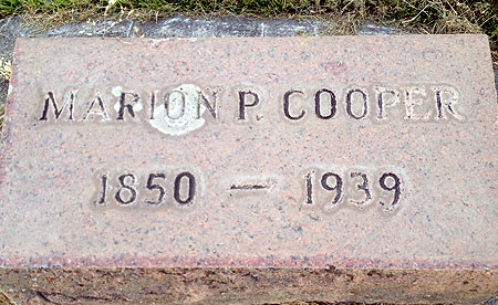
David Rose Cooper died shortly thereafter, in 1922, at the age of 77. Marion Cooper lived on for several years in the family homestead near Parkdale. She died at age of 89 in 1939, having experienced an amazing span of history during the course of her long life.

A visit to Upper Valley Cemetery

After researching the remarkable Cooper family history, I made a trip to the Upper Valley Cemetery near Parkdale a few weeks ago to visit the family’s gravesites. This quiet little cemetery is modest and unassuming, appropriately nestled between working apple orchards on all sides.

David Rose Cooper’s gravesite is located in the open center of the cemetery, and Marion Cooper’s grave is just a few feet away. Standing by their grave markers, Mount Hood rises to the south, and Bald Butte fills the skyline to the east.

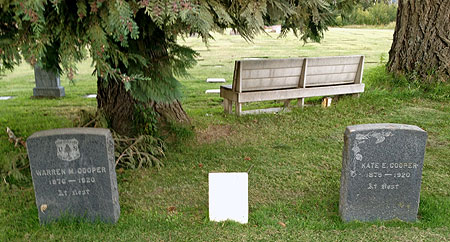
Barney and Kate Cooper were laid to rest along the west edge of the cemetery, beneath the canopy of a huge Douglas fir and Port Orford cedar. A wood bench is located nearby, between the trees, facing the main part of the cemetery.

Gravesites of Barney, Kate and Baby Cooper

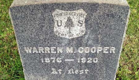
Barney’s grave marker is engraved with the U.S. Forest Service emblem – a forest ranger forever! Kate’s marker is a few feet away, and adorned with what seems to be a morning glory vine — her favorite flower, perhaps?

Between Barney and Kate lies their infant daughter, the first to be buried here in their shady family plot.

________________________

A Lasting Tribute?

Before he died at the age of 97 in 2010, Wilbur Cooper had survived his wife of 73 years, Juanita, and one of their twin daughters, Leslie. According to published accounts, he is survived by his daughters Rosemarie and Carrolyn, son-in-law Jon, four grandchildren and two great-grandchildren.

My hope is to somehow contact his surviving family so that they might learn about my efforts to restore Warren Falls on Warren Creek — places named for a grandfather they never met. This effort is complicated by the fact that Wilbur Cooper had no sons, and thus the Cooper surname may not have carried forward in his branch of the family.

A fitting tribute to Barney Cooper?

Learning a bit more about Warren “Barney” Cooper in researching this article further inspires me in restoring Warren Falls. It would be a fitting tribute to his contributions as one of Mount Hood’s first rangers.

I’m also hopeful his surviving descendents might be able to shed more light on Warren Falls and Warren Creek — and on Barney Coopers life in the woods. If you know someone in the Cooper family who might be able to help me in that effort, please forward this article to them.
________________________

For more family history on Barney and Wilbur Cooper:

• L.J. Cooper’s Recollections of Barney Cooper (PDF)

• Wilbur Cooper’s 2010 obituary (PDF)

As always, Jack Grauer’s “Complete History of Mount Hood” (first edition) was invaluable in putting this article together.

The author on Cooper Spur in September 2012

Money Plant

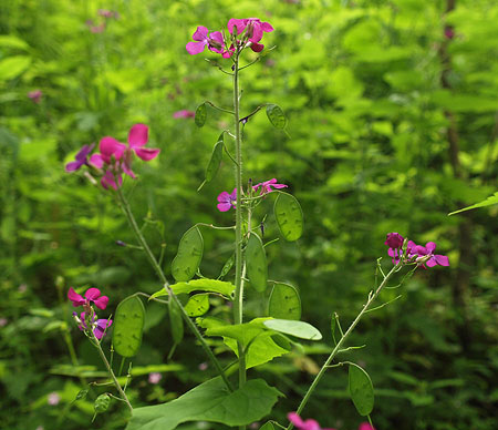
Spring brings a stunning array of wildflowers to the Columbia River Gorge, and one of the most striking is the Money Plant (Lunaria annua), also known commonly as Silver Dollar Plant and Honesty. Its botanical name “lunaria” refers to its moon-shaped seed pods. But it turns out that Money Plant isn’t really a native — more about that in a moment.

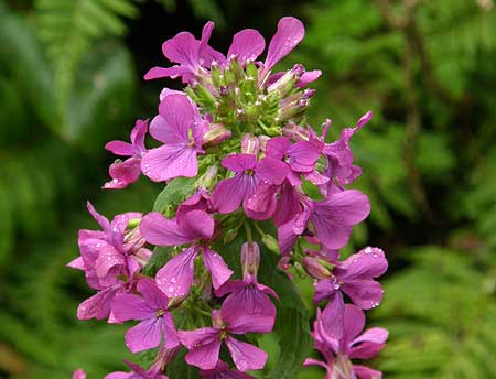
This beautiful species produces lush purple, lilac and white blossoms on tall stalks in spring. But it is the namesake “silver dollar” seed pods — known as a “silique” — in fall and winter that are most familiar to us.

Money Plant typically grows in scattered roadside drifts, and can be found along the western sections of the Historic Columbia River Highway where it favors sites with rich soils and filtered sunlight.

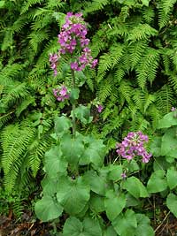
Typical Money Plant coming into bloom in its second year

Money Plant is a biennial, which means it takes two years to complete its lifecycle from germination to flowering and seed production.

In its first year the Money Plant sprouts from seeds in early spring, and over the course of summer develops leaves, stems, and roots substantial enough to survive the subsequent winter, when the plant becomes dormant.

In its second year, the Money Plant emerges from dormancy and “bolts” to produce tall flowering stems by late spring. The blossoms open from the bottom of the emerging stalk, and proceed to bloom at the growing tip of the flower stem, even as the earliest flowers have transformed into green, developing seed pods.

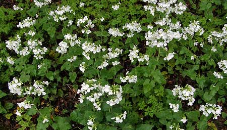
Money Plants blooms come in purple, lilac …and white

By early summer, most of the blooms have dropped, and the flower stalks have transformed into a bouquet of flat, green discs. These are the pods, or “siliques”, that hold developing seeds, and will soon mature to become the more familiar “silver dollars”.

Middle stage: green “dollars” forming along the flower stalk

“Dollars” are already forming on this plant, even as the tip of each flower stalk continues to bloom

Close-up view of the young seed pods shows the tiny dots that will mature into pea-sized seeds

By late summer of their second year, Money Plants have put all of their energy into producing viable seeds, whereupon the plant dies and turns a tawny brown as it dries.

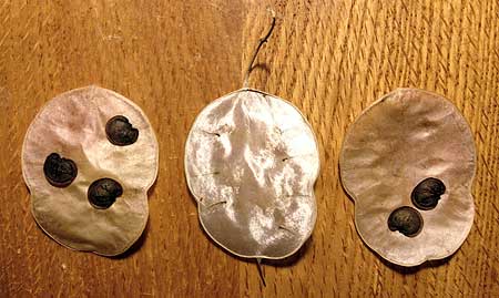
Finally, the outer skin of each seed pod shrinks enough to become brittle, eventually popping off to release the seeds. Two to four flat, kidney-shaped seeds adhere to the pair of outer skins, allowing them to carried a short distance from the mother plant in the first fall storms, with the skin serving as a mini-sail.

Mature seeds still attached to the mother plant

Some of the seeds have fallen from these pods, revealing the first few “silver dollars”

Close view of the two outer skins of a silique and the shiny inner membrane “dollar”

Once the outer skins are shed from the seed pods, the Money Plant takes on its most familiar form. Each pod has an iridescent central membrane that dries to form the “silver dollar” that is reveled when the outer skins and seeds have been shed. These “dollars” remain on the plant through the winter and beyond, and even have commercial value as floral material.

Money Plant at the end of its lifecycle, with all of its seeds shed, leaving only a skeleton of the plant (source: Wikimedia)

Surprisingly… not native!

As non-natives go, Money Plant looks right at home among the native wildflowers of the Columbia Gorge. The plants are attractive, aren’t particularly aggressive and tend form only scattered small drifts among our native species.

It’s no secret how Money Plant naturalized: you can find Money Plant sold as a garden ornamental around the world, as the appeal of the plant is universal: showy flowers, attracts butterflies, valued for its dried form and easily grown from seed.

In a garden center near you?

Thus, this native to the Balkans of Southeastern Europe has since naturalized throughout the world – including our own Columbia River Gorge.

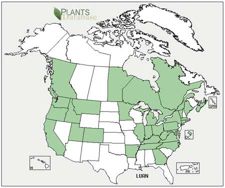
The following map shows Money Plant naturalizing in pretty much every temperate state, but notably where winters are cool enough to trigger its biennial growth stages:

Source: USDA

In Oregon, the plant is listed as “moderately invasive” by numerous public land agencies and native plant organizations, though not on the “100 Worst List” of noxious species targeted by the State of Oregon for eradication.

Meanwhile, Money Plant seeds have found a new niche as a promotional gimmick, with marketers selling customized seed packets — most often for financial institutions, but also for other organizations.

It is therefore unlikely that Money Plant will ever be eradicated from Oregon — but also doesn’t seem to be a destructive invader. It thrives among native plants, but doesn’t seem to smother them. Compared to other, more aggressive invaders, Money Plant seems more “naturalized” than “invasive”.

Should you grow Money Plant?

So, now you’re feeling guilty about those Money Plant seeds you collected to plant in your garden, right? Clearly, millions of Americans have done the same — or simply purchased a pack of seeds at their local garden center (or received a pack from their bank – as I recently did).

Once planted, Money Plant is also very good at propagating itself in your garden – just as it does on roadsides. So, for most gardeners, that’s a benefit since the plant is a biennial and must be replanted annually, though that is also what makes the plant invasive.

Who wouldn’t want this flower in their garden..?

So, is it okay to grow an “invasive” species..? Generally, the answer is “no”. But here’s a responsible way to grow Money Plant in your garden: simply cut the drying seed stalks (whether from your own garden, or collected in the wild) as they’re beginning to turn yellow, but before they’ve become brittle enough to release seeds. This prevents the seeds from scattering on their own, potentially beyond your garden.

Next, hang the cut plants in a garage or basement to completely dry. Once dried, you can shake the outer silique skins (and seeds) from the plants into a paper bag, and use the shiny inner “silver dollars” that remain on the stems for decoration. This allows you to collect and sow the seeds you harvest where you can keep an eye on the plants, and carefully control where the seeds go.

If you’ve collected your seeds in the wild, then you get bonus points: in addition to having some beautiful flowers in your garden, you’ve also done your part to keep the naturalized population in check, as well. That should go a long way in easing your guilt..!

Warren Falls story airs October 25th on Oregon Field Guide!

The Magnificent Seven ready to head to Warren Falls on May 12

If you’ve followed this blog for awhile, you may remember this article from last spring. This earlier article documents the field shoot at Warren Falls for a story on OPB’s Oregon Field Guide.

The segment finally airs this week at the following times on Oregon Public Broadcasting:

• Thursday, Oct. 25 at 8:30pm

• Sunday, Oct 28 at 6:30pm (repeat)

After the story airs, it will be viewable on the Oregon Field Guide website:

OFG Warren Falls Episode

Vince and Michael at work along Warren Creek

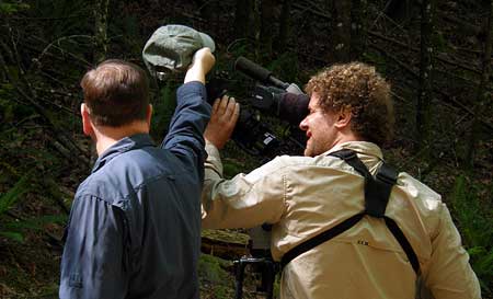
Thanks go out to Vince Patton and Michael Bendixen, the brave OFG crew who made a couple of trips to Warren Falls to capture the story. Along the way they braved an ice storm, waded through knee-deep poison oak, dodged cliffs and dangled beneath the huge “trash rack” that covers the top of the Warren Falls diversion. They are true adventurers to the core!

The crew spent two separate days on site, and captured what should be some very intriguing views of the Warren Falls diversion structure — including that glimpse under the weir, looking into the tunnel. The video from our earlier, icy winter trip should be interesting, with some surprises, I suspect.

OFG shooting at the base of Warren Falls last May (Photo: Adam Sawyer)

ODOT continues to move forward toward construction of the Historic Columbia River Highway State Trail segment from Starvation Creek to Warren Falls, so stay tuned! I’ll continue to post information on the effort to restore the falls on the blog, as well as on the Restore Warren Falls Facebook page:

Restore Warren Falls on Facebook

An Oregon Classic

The granddaddy of Oregon field guides was published in 1969

Today, you can walk into a Portland bookstore and find dozens of hiking guides, most with a narrow geographic focus or hiking speciality — hiking Mount Hood, hiking with dogs, hiking with kids, day hikes, backpacking trips — that cater to every stripe of hiker.

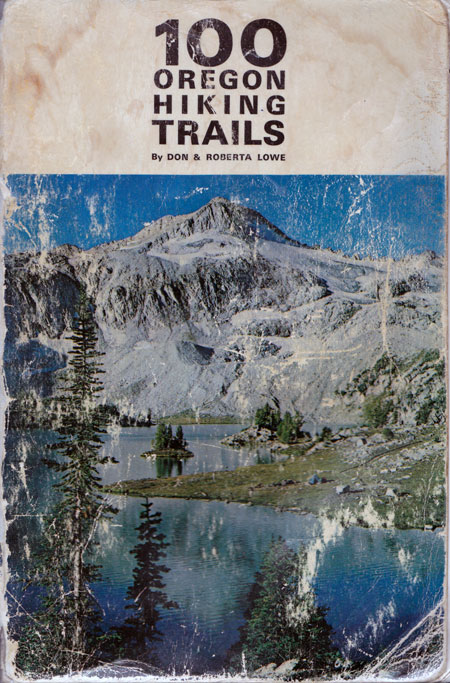
But in the beginning, there was only one guide: 100 Oregon Hiking Trails by Don and Roberta Lowe. The book was published by the Touchstone Press in 1969, and was the first of many guides that established the Lowes as the undisputed experts on hiking in Oregon.

Family heirloom: frontpiece of our original copy, signed by Don Lowe

100 Oregon Hiking Trails set the bar for what every hiking guide is still judged by. The Lowes hiked every trail in the book to ground-truth and map actual trail locations, covering 1,400 miles in their efforts. Each hike includes Roberta Lowe’s detailed narrative describing the trip and a summary of basic trail data, including elevation gain and loss, mileage, hiking season and driving instructions.

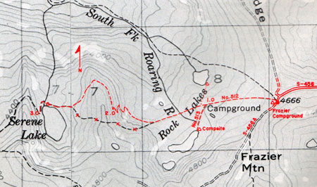
Don Lowe is an accomplished photographer, and captured photos for each hike. Don also created custom trail maps using USGS topo sheets as his base — and often correcting the actual trail location, adding trail highlights and mapping forest road updates.

The result was a pioneering guide that many hikers carried in their packs (after all, this was the era when photocopiers were still rare!) and relied upon as their “eleventh essential”.

Typical map from 100 Oregon Hiking Trails – this one is for the Serene Lake hike

Exactly half the trips in 100 Oregon Hiking Trails are day trips from Portland, and another thirty are in the Central Oregon Cascades. The twenty remaining trips are spread across southern and eastern Oregon. Most of these hikes are still classics, covered many times over in field guides published over four the decades since the Lowes first described them.

But while the destinations are the same, many trails have changed significantly since 100 Oregon Hiking Trails was published: most of the trails we know today on Dog Mountain and Silver Star Mountain today simply didn’t exist in 1969, for example. In a few cases, the destination itself has changed: former lookouts are gone (Silver Star Mountain, Saddle Mountain, Bald Butte), viewpoints partly grown over (Lost Lake Butte, Fish Creek Mountain) or trails simply lost (the Perdition Trail).

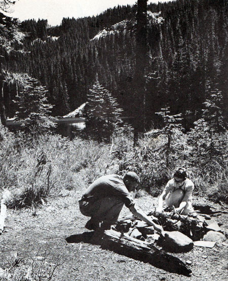
Don and Roberta are pictured building a fire at Serene Lake in “100 Oregon Hiking Trails

Perhaps most importantly, 100 Oregon Hiking Trails was a hedge against the sharp decline in forest trails that accompanied the escalating timber harvests on federal lands in the 1950s and 60s. Though clear cuts and logging roads claimed many more trails during the logging heyday that continued through the 1980s, the Lowes inspired countless Oregonians to rediscover their forests. These new hikers, in turn, brought a new awareness of the heavy toll that industrial forestry was having on our public lands.

Growing up with 100 Oregon Hiking Trails: My First Backpack

Like most outdoor-oriented Portlanders in the late 1960s and 70s, my family had a copy of 100 Oregon Hiking Trails out on the coffee table (right next to Ray Atkeson’s Oregon, Jack Grauer’s Mount Hood: A Complete History, Maynard Drawson’s Treasures of the Oregon Country, Ralph Friedman’s Oregon for the Curious… and a few recent issues of LIFE magazine).

Ready for adventure: Mom, sister Carol and older brothers Kurt and Mark with yours truly getting ready to load up the station wagon. Dad is behind the camera, and oldest brother Pete off to college.

My earliest family day hikes in the Gorge and around Mount Hood were at the age of five or six. But after reaching the ripe old age of eight in 1970, my folks deemed me old enough to carry my own backpack. It was July, and the destination was Hike No. 43 in 100 Oregon Hiking Trails: Serene Lake. This trip still stands as my earliest hiking memory, and made me a hiker for life.

The trip started from the Frazier Turnaround, reached by a primitive road that was just as rough in 1970 as it is today. Back then, my dad was navigating an aircraft carrier-like 1967 Plymouth Fury II station wagon over that road – a thought that seems terrifying today. I recall a lot of lurching and grinding through the boulders and dust-filled potholes that pass as “road” along this route… and some choice expletives from dad, of course!

Once at the trailhead, we saddled up in packs ranging from cutting edge (my folks and older brothers had spiffy orange Kelty backpacks) to retro — my sister and I had military surplus canvas packs from Wigwam, a 60s-era army surplus store in Portland. Thankfully, our canvas packs had “modern” aluminum frames – an improvement over oak! The same held for our tents: my folks slept in dad’s orange, nylon climbing tent, while my older brothers carried two army surplus canvas pup tents for the kids. Dad reviewed the route in our copy of 100 Oregon Hiking Trails, then stowed the guide in the top pocket of his pack.

Rest stop at the two-mile mark on the switchbacks below Serene Lake – that’s me running around annoying everyone, no doubt…

The hike was uneventful, and soon we arrived at the north shore of Serene Lake, right where the Lowes are pictured in the guide. We had plenty of day left for exploring, a very quick (and cold) swim, wading in search of crayfish and a picnic on the talus slope above the lake.

Finally, it was time to set up camp. We stayed on the west shore of the lake, where I’m fairly certain at least one rustic picnic table existed. The canvas pup tents came with heavy metal stakes, but no poles – we used sticks for that. They also had simple cotton ties for closures, a detail that would prove fateful as evening approached.

Mom set up an impromptu picnic lunch on a talus slope above Serene Lake.

As sundown approached, the infamous mosquitoes of the Rock Lakes Basin descended upon us with a vengeance. Dad sprayed the kids down with a can of OFF! bug spray, and built a campfire to make our dinner. The fire did a good job of keeping the bugs away, so we stayed up late, roasting hot dogs and marshmallows in the warm, bug free circle.

Bedtime brought on a sequence of memorable events that are now family lore. I was paired with Kurt, my oldest brother on the trip, and our first unpleasant discovery was just how impossible it would be to keep mosquitoes out of that pup tent. More drama followed: at some point during the night, I woke my brother up to tell him I was about to throw up.

Our recollections vary on what happened next, but I distinctly remember being ejected from the tent like a human missile, and spending the next 20 minutes (or was it hours?) hunched in a patch of huckleberries paying the price for all those hot dogs and marshmallows. At some point, I was allowed back in the tent, but only after losing another pint of blood to the mosquitos… and my dinner.

A mummified mosquito is proof that dad opened up the guidebook at least once during our buggy stay at Serene Lake!

Despite the long night at Serene Lake on that first backpack trip, I was hooked. After the hike, I pored over our beat-up copy of 100 Oregon Hiking Trails, memorizing it. Our family went on to hike many of the trails described in the book, and in later Lowe guides (that I also memorized). The die was cast, and I was addicted to hiking for life.

These early experiences are why I LOVE to see parents with young kids out on the trail — they’re setting them on a very healthy, satisfying path… literally! An added bonus is that hikers are among the best forest stewards and conservationists, simply because they come to know the land on a very personal level.

The Lowe Legacy Continues

100 Oregon Hiking Trails was only the beginning for Don and Roberta Lowe. Within a year of its publication in 1969, their second book, 100 Northern California Hiking Trails, was published in 1970. Many books followed over the next three decades. Each of the subsequent books is more focused in scope, including regional hiking guides for Oregon, Southwest Washington, Northern California and Colorado. The Lowes also wrote one of the first mountain biking guides for Oregon, in 1991.

The back cover of 100 Oregon Hiking Trails features the dynamic Lowe team at work.

All of these books are worth collecting if you’re a hiker interested in trail history, or exploring those “lost trails” that have dropped off Forest Service maps and maintenance schedules, but can still be followed.

A favorite among the later Lowe books is 50 Hiking Trails: Portland and Northwest Oregon, published in 1986. This classic is still sought after for its description of some of the most threatened, least traveled trails in our region, and has helped these trails survive by introducing new generations of hikers to them.

Don and Roberta Lowe’s epic tribute to Mount Hood (1975)

Perhaps the finest Lowe collectible is their beautiful large-format book Mount Hood: Portrait of a Magnificent Mountain, published in 1975. Though Don Lowe’s photographic talent is evident in the small, black and white images that fill the many Lowe guidebooks, the beautiful collection of Don’s fine color photography in this book is simply stunning. Likewise, Roberta Lowe has the space in this book to expand her prose to a compelling story of Mount Hood’s natural and cultural history. This is a must-have for Mount Hood lovers, and can still be found at local bookstores.

———————–
Postscript: this is the 100th article posted on the WyEast Blog since starting it nearly four years ago, so celebrating 100 Oregon Hiking Trails seemed like the perfect topic! The books of Don and Roberta Lowe had a big impact on my life, and I’m sure many others were influenced by their celebration of Oregon’s wild beauty.

In the early 1980s, I approached Don and Roberta Lowe for help with a college project: creating a trail map of the (then) embattled Salmon-Huckleberry backcountry as part of the campaign to preserve the area as wilderness (which eventually happened in 1984).

The Lowes invited me to their home to discuss the project, and patiently endured my endless questions. Don even gave me a tour of his basement darkroom, where all those maps and images I had memorized had been created. Roberta kept up a correspondence on my student project for over a year, and I still keep those old letters as a reminder of their generosity in helping a young student with their time and knowledge.

I ran into the Lowes again about a year ago, and in catching up with them, was reminded once again what a gift they were to Oregon. They were an important part of that special Oregon spirit of the 60s and 70s that still defines what it means to live here today.

Thanks, Don and Roberta!

Our Gorge: Their Summer Destination..!

Look! Behind you… it’s Multnomah Falls!

Thanks to being one of the country’s original motoring routes, countless automobile ads have been filmed along the Mount Hood Loop Highway over the years. Usually, our world-class scenery is little more than an un-credited extra in the casting, though always a welcome affirmation of the national park qualities of Mount Hood and the Columbia Gorge!

But this summer, two new ads from Infiniti get more personal with the Gorge as “your summer destination”. True, it’s the luxury Infiniti G Sedan (and the affluent buyers they are courting) that the company has in mind, but like few ads before it, these 30-second spots use the Gorge setting as the main selling point. They’re fun to watch for local Gorge enthusiasts, especially some digital slight-of-hand for the sharp-eyed.

Cruising Waterfall Alley

The first ad opens with a stylish 30-something couple in a contemporary art gallery, admiring a metal sculpture. Behind them is a rather nice abstract painting of Multnomah Falls, featuring the Benson Bridge (was it created for the ad?).

After a brief daydream involving a cruise ship and spritely grandpa running by in a red Speedo, the couple turns toward the painting behind them and proclaims: “Let’s go on vacation there!”

Ah, now you see it! Nice painting, too…

Cut to a lovely summer view of Multnomah Falls and Benson Bridge… and a car zipping across the pedestrians-only bridge…? Clearly, a driving maneuver made possible through the miracle of computer generated imagery (CGI), but fun to see for those who know the location!

Look out, pedestrians! Luxury sedan coming through..!

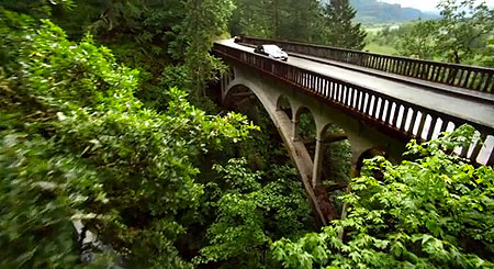
Before your eyes can zero in on the car atop Benson Bridge, the scene cuts to the same car coming across the similarly arched Shepperd’s Dell bridge. For the national audience watching this ad, the two bridges do appear to be the one and the same, adding to the fun for local Gorge aficionados who know better.

Aren’t you going to slow down for the waterfall..?

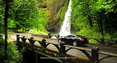
From Shepperd’s Dell, the sleek new Infiniti now passes in front of Horsetail Falls as the fine print appears: “Professional driver. Closed course. Do not attempt.” Good advice… especially if you still owe on your $37,000 luxury sedan!

Nope, not stopping at this falls, either…

Next, the ad cuts to a section of historic highway that appears to be just east of Shepperd’s Dell, with a verdant green forest canopy reflecting off the hood of the well-polished Inifiti. A squiggly “sharp turns” sign completes the scene and message: sure, it looks like a sedan, but it drives like a sports car!

That squiggly arrow means “go faster”, right..?

Then, another abrupt U-turn, and we complete the high-speed tour of Waterfall Alley with a spin around Crown Point. The colors and river level in the background show this scene to have been filmed in the peak of spring in May or early June, under overcast skies, as were the previous clips in the sequence.

Hey, you’re speeding past a world-class viewpoint..!

The exception is the opening Multnomah Falls shot — the only clip without an actual vehicle operating in it. This clip appears to have been filmed later, possibly mid-summer, and clearly under sunny conditions, too. Could this be a stock video clip with the CGI added?

Here’s the complete video of “your summer destination” in Waterfall Alley – enjoy the ride!


______________________

Cruising Rowena Crest

One of these ads would be fun enough for local Gorge junkies to study, but a twin ad filmed in the eastern Gorge is equally intriguing. This commercial begins with a somewhat younger 30-something couple (the Infiniti G is apparently an “entry level” luxury model… hmm…) this time admiring a mysterious coffee table book in an upscale bookstore (is this a film set, or real location..?)

Definitely not Powell’s, but the book looks interesting…

Like the first couple, this pair daydreams of a tropical vacation (on Bora Bora), then comes to their senses when a coconut thumps the hood of their hyper-polished Infiniti sedan. Startled from their daydream, they take a look at the two-page spread in the huge art book before them and proclaim: “Let’s go here!”

…now the book looks REALLY interesting!

The colossal book looks like it must be a custom-made prop, but does have a caption running down the left side that describes driving this scenic route in Oregon — perhaps this is a real book?

If so, the camera crews went to extraordinary efforts to match the location for the first shot in first video sequence — or is it the other way around? If the book was created as a prop for the ad, the stills of this scene for the book were clearly shot later in the summer than the filming of the driving sequences, as evidenced by the summer colors along the freeway and Sevenmile Hill, in the background.

A couple of quick cuts in the opening sequence along the historic highway show off a lovely section of Samuel Lancaster’s beautiful old road, featuring the artful stonework and remarkable effort to blend with the landscape that continues to make the Historic Columbia River Highway a “summer destination” for visitors from around the world.

Ah… you might want to slow down on this curve…

…or not… glad there’s a “professional” at the wheel…

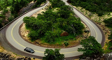
Next, the still spotless Infiniti sedan makes another time-travel maneuver, appearing on the Rowena Loops, just to the east of the opening clip. This is one of the most photographed sections of the old highway for the purpose of selling fast cars, so an expected clip in this ad.

Clearly, he saw another squiggly arrow sign…

The next clip is back in geographic sequence, picking up the sedan as it passes another terrific Lancaster design feature: the graceful roadside viewpoint just below Rowena Crest. Though a bit sketchy for pulling off (especially with professional Infiniti drivers speeding by), this little overlook is one of the lovelier details along the historic highway.

Wait! Another view… point… eh… never mind.

The second ad ends up with another leap to the east, near Rowena, proper, just below the loops. The amazingly bug and dust free Inifiti zooms past a nice section of restored wooden historic highway guardrail before the commercial fades to text.

The shiniest car to ever visit Rowena?

Here’s the complete video for the second ad – another fun 30-second ride!


______________________

Do these ads matter?

Beyond the welcome confirmation by Madison Avenue of the Gorge and Mount Hood as places of national park caliber (and generally assumed as such by most out-of-state visitors), these moments in the national spotlight have real benefits for our region. I tried a few web searches using the catch phrase from the ad, and found many queries and discussions from curious viewers trying to figure out where these ads were filmed.

A Google search for “Infiniti commercial” shows the waterfall spots to be popular

If ads like these translate into out-of-state visitors coming to experience the Columbia River Gorge and Mount Hood for themselves, it’s a big win for the local economy: visitors from outside our region spend much more than locals when they’re here, especially on lodging and dining.

That’s a good thing for the Gorge and Mount Hood communities, even if we can’t take credit for the free advertising — our breathtaking landscape gets star billing for that!

The Boot Loop: Bringing Transit to Mount Hood

There is a surprisingly long, sometimes strange history in the effort to bring public transportation to Mount Hood. Private ski buses have carried winter visitors to the mountain almost since the beginning of the south side resorts. Before that, visitors to Cloud Cap journeyed by train, then stage, to reach the mountain at the turn of the 20th Century.

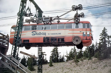
Perhaps the strangest episode was the brief reign of the Skiway to Timberline, an ungainly gondola scheme consisting of a customized bus suspended on a cable lift. The Skiway carried skiers from Government Camp to Timberline Lodge in just 10 minutes, with two modified coaches called “Cloudliners” custom-designed for the circuit.

Was the Skiway to Timberline ahead of its time?

The system cost a hefty $2 million when it was completed in 1951, but only operated until 1956 due to chronic mechanical problems and disappointing interest from skiers. Though it seems absurd now, the operators actually filed for permits to extend the Skiway to the summit of Mount Hood, then down the north face to Cloud Cap before the entire enterprise stalled.

Today, a ski trail carrying the name is the only reminder of the Skiway. The base terminal survives, but is nearly unrecognizable, having been converted into condominiums.The following newsreel captures the spirit if the Skiway in its early, more optimistic days:

In 1986 the first of Portland’s light rail lines opened, reaching out to the suburb of Gresham, 15 miles east of downtown. The system was an immediate hit with Portlanders, and soon there were enthusiastic calls for extending the tracks to Mount Hood. It was never to be, of course, simply because of the sheer cost of building a line on that scale (Government Camp lies 40 miles and nearly 4,000 vertical feet above Gresham) that would never draw enough passengers to justify the expense. Yet, it was conventional wisdom that some sort of public transportation to Mount Hood was needed.

Could transit to Mount Hood work?

During the recent economic downturn, the lack of a transit option has been still more glaring, with gas prices topping $4 per gallon, and an increasing number of Portlanders simply opting out of owning an automobile. For many skiers, hikers and mountain bikers, this once again raises the question: why isn’t there public transit to Mount Hood and the Columbia Gorge?

The simple answer is that none of the public agencies with jurisdiction for the area is even considering the option. The Forest Service has placed a few conditions on ski resorts to provide limited transit, but otherwise is silent on public transportation.

The Oregon Department of Transportation (ODOT) has the authority to step up, and even commissioned a 1999 feasibility study for the US 26 corridor. But instead of exploring the recommended transit options, ODOT has since focused its efforts on widening the highway in response to ski-weekend traffic bottlenecks, to the tune of nearly $50 million over the past 12 years. To date, only the National Park Service has embraced recreation transit, with bus and shuttle systems serving several national parks.

The National Park Service already provides transit service in several parks (NPS)

This leaves ridesharing as the only viable alternative to driving alone to the trailheads for skiers, hikers and cyclists. While many hikers take advantage of sponsored hikes and informal meet-ups to take advantage of this option, there is no organized rideshare system available to the public.

What would it take to provide meaningful transit to Mount Hood and the Gorge? This article attempts to answer the logistics of that question, and explores whether a system could actually designed with hikers and cyclists in mind. In this way, the proposal differs from past schemes in that it focuses on hikers and mountain bikers, not ski resorts.

Proposal: The Boot Loop!

Over the years, many people have asked me about transit to Mount Hood and the Gorge, perhaps because they know I’m a transportation planner by day. And while my professional background made this proposal easier to assemble, it goes without saying that this is simply a “what if” concept. It’s meant to show just one way in which transit on Mount Hood might work. In the end, transit is a complex balance between ridership and service levels, and only a thorough transit study can produce a real plan. Instead, think of this as a hiker’s plan for transit, hopefully to spur some discussion!

The proposed Boot Loop consists of three overlapping bus transit lines:

• Mount Hood Line (orange) – seasonal route serving the Mount Hood Loop on weekends (Friday-Sunday) from June through October

• Hood River Line (yellow) – year-round route serving the western Gorge on weekends (Friday-Sunday)

• Cascade Locks Line (green) – year-round, all-week route serving the most popular trailheads in the Gorge

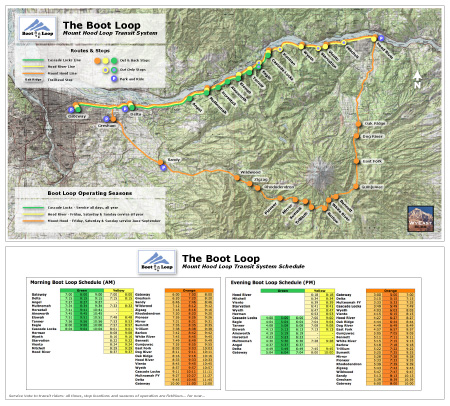
Here’s a map of the proposed system:

(click here for a very large, printable version of the map)

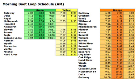
Here’s a closer look at how the schedules could work for these lines (these are clips from the Boot Loop map, shown above). All lines begin at the Gateway Transit Center, the nexus of three light rail lines on the MAX system and home to a large park-and-ride structure.

Hikers already use Gateway as an informal meet-up site for ridesharing, so it’s a natural location for the Boot Loop. The proposed service starts on the hour, beginning with an early departure of the Mount Hood line at 6 AM and the Gorge lines beginning at 7 AM.

Morning transit service on the Boot Loop

(click here to enlarge)

A total of eight buses would depart in the morning on full service, summer weekends: three for Mount Hood, three for Cascade Locks and two for Hood River. All three lines would have additional park-and-ride stops, with the Mount Hood Line stopping at the Gresham Transit Center, Sandy City Hall and Hood River, and both Gorge lines stopping at a new park-and-ride at the Sandy Delta interchange (and trailhead).

By design, the Gorge lines have several overlapping stops, with the weekend service provided by the longer Hood River line helping carry extra demand for the most popular western Gorge trailheads.

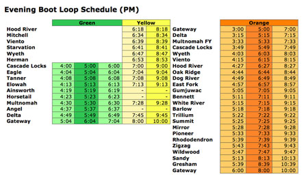
Evening transit service on the Boot Loop

(click here to enlarge)

Some Gorge stops would only have morning service, due to westbound freeway access constraints. These include the Eagle Creek, Herman Creek, Starvation Creek and Mitchell Point trailheads. With the exception of Mitchell Point, all have trail access to nearby trailheads that would have PM service, so this would mostly require some advance trip planning for hikers. If the completion of the Historic Columbia River Highway State Trail stays on schedule, Mitchell Point will soon have trail access to a nearby trailhead (Viento), as well.

A closer look at the proposed bus schedule reveals another benefit of overlapping service: in summer, the Mount Hood Line returning through the Gorge provides additional mid-day and evening return options, giving hikers a lot of flexibility in planning their day.

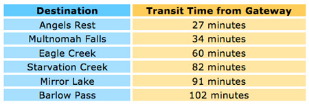
For accuracy, I clocked travel times for all three routes, including dwell time for unloading passengers, gear and bikes, so these are pretty close to what you could expect from this proposal. How fast would the ride be? Some of the more popular destinations, as measured in travel time from Gateway:

These times are competitive with driving, and if the service seems surprisingly fast, that’s because there are few stops on any of the proposed lines compared to urban transit systems.

Transit Stops for Hikers

One of the unique considerations for recreation transit is providing shelter at the trailheads. While urban systems might be able to get by with a metal sign tacked to a phone pole, hikers would need more protection from the elements, especially if they arrive early for a return trip home.

The National Park Service sets the standard for transit shelters, with substantial, rustic designs in its major parks. Similar designs would make sense for the most popular trailheads like Angels Rest, Horsetail Falls or Mirror Lake.

National Park Service example of a more substantial transit shelter (NPS)

For less busy trailheads, a simpler design could work, though the purpose of the structure is as much psychological as practical: it protects you from the elements, while also reassuring you that the bus will stop when it comes by.

Some examples of more modest structures follow:

Rustic rural transit shelter in Great Britain (Wikipedia)

Simple covered picnic table that could serve as a basic trailhead transit shelter (Wikipedia)

One reason urban transit providers avoid shelters is the cost of maintaining them, given the sheer number of stops in an urban setting (TriMet maintains more than a thousand shelters). But in a recreation setting, the shelters serve anyone using a trailhead, which opens up a number of options for building and maintaining these facilities as multi-purpose shelters and interpretive stops.

What about the buses?

One of the persistent complaints about bus transit is simply the “closeness” factor, something modern urban buses have addressed in recent years with greatly improved ventilation and climate controls. Modern excursion coaches are even better, and the vehicles used in the Boot Loop would be like these vehicles — with coach seats, onboard restrooms and large cargo areas for bikes and packs. The tradeoff is seating capacity, with excursion buses generally carrying from 44 to 52 passengers.

All-electric urban transit vehicles are becoming affordable (Wikipedia)

Buses also don’t have to be loud and polluting, anymore. Around the world, transit providers are increasingly looking at alternatives to diesel buses, with Asia boldly leading the way. China used a fleet of 50 all-electric buses in the 2008 Olympics, bringing the technology into the forefront. Metropolitan Seoul, Korea now runs an all-electric fleet, and many other urban transit providers are moving toward electric vehicles.

All-electric excursion buses providing park transit in China (Wikipedia)

Current battery technology has extended the range of electric buses to almost 200 miles on a charge, easily meeting the requirements for the Boot Loop between charges. These vehicles are currently more expensive than diesel, but prices are coming down, and they have the advantage of zero emissions and much quieter operation — big advantages when operating in a natural environment.

What would it take?

So, what would it take to bring transit to Mount Hood? For starters, an understanding that no transit system pays for itself with fares, alone. Just as automobiles pay for a fraction of the roads they require, transit typically recovers about a third of the operating expense with fares. With that assumption as a starting point, you can scale the total system accordingly, based on a rough estimate of fares.

Let’s do the math: at peak operations, with eight buses carrying a full load of 44 passengers (based on the proposed schedule), the system could draw about 700 one-way fares on a summer weekend. If you figure about $10 for a one-way ticket (or $20 round trip per hiker), that would generate $7,000 toward the 36 total hours of bus operation per day needed to run the Boot Loop, or nearly $200 per operating hour.

With most urban transit systems running operating costs of less than $100 per hour, this rough calculation seems to leave a lot of room for less-than-full buses and the other expenses of running a system, assuming an operating subsidy similar to what urban transit receives.

Parking capacity is a major problem at many trailheads; transit could help reduce demand

Electric buses cost upwards of $500,000, and the Boot Loop would require eight (including a spare). Likewise, the system would require 30 new transit stops, some with sizable shelters. Thus, the front-end capital price tag to start up the system I’ve described here would easily be in the range of $5-7 million. This startup number sounds big, but in transportation dollars, it’s well within the realm of the possible.

But the real commitment in providing transit comes in the ongoing support for operations. That’s where a useful model comes from Timberline Lodge, another venture for the public good that requires ongoing public dollars and private support to exist.

The lodge is managed by a triad consisting of the U.S. Forest Service (which owns the lodge on behalf of the public), the RLK Company (which operates the lodge and ski resort), and the Friends of Timberline, a non-profit that advocates for the preservation of the structure. Together, these partners ensure that the public enjoys the successful operation of Timberline Lodge as a public/private endeavor as no single partner could.

Sleeping is the best way to travel (Wikimedia)

A similar model could work for the Boot Loop, with the Forest Service providing trailhead bus stop improvements, ODOT providing operating funds and vehicles, and a transit provider actually operating the system. TriMet could certainly operate it, but it could also fall to the City of Sandy’s SAM system to operate, or even a private operator. They key is an understanding by the partners that all three have a stake in providing successful transit — and this is where the Forest Service and ODOT still fall short.

Another core premise behind this proposal is that hikers and bikers may be more motivated to use transit than the public at large, for reasons ranging from personal ethics (a more sustainable way to travel), convenience (relax or even sleep to and from the trailhead) to simple economics (cheaper than driving, and no car at the trailhead to get looted). Is this premise true? There’s no way to answer that question, short of a thorough market study, but this article is intended to help the conversation along.

Transit does finally seem like the right solution at the right time for Mount Hood and the Gorge. If the demand is there, are ODOT and the Forest Service ready to step up? We’ll see.

The Wahclella Maple

Autumn sunburst lights up the Wahclella maple in late 2011

Sometime last winter a picturesque bigleaf maple framing Wahclella Falls tumbled into Tanner Creek, likely under the stress of heavy snow or ice. In any other spot, this event might have gone unnoticed, but the Wahclella maple had the distinction of a front row seat at one of the most visited and photographed waterfalls in the Columbia River Gorge.

“Change is the only constant. Hanging on is the only sin.”
-Denise McCluggage

Tanner Creek gorge is no stranger to change. In the spring of 1973, a massive collapse of the west wall, just below Wahclella Falls, sent a huge landslide into the creek, temporarily forming a 30-foot deep lake behind the jumble of house-size boulders. Today, the popular Wahclella Falls trail crosses the landslide, providing a close-up view of the natural forces that have created this magnificent place.

By contrast, the demise of the Wahclella maple is a very small change, indeed. But a closer look provides a glimpse into some of the more subtle changes that are part of the perpetually unfolding evolution this beautiful landscape. The following are nearly identical photos captured six years apart, in 2006 and 2012, and the changes over that short span are surprising:

[Click here for a larger view]

Comparing these images, one obvious change is in the stream, itself where (1) an enormous log has been pushed downstream by the force of Tanner Creek, testament to the power of high water. In the center of the scene (2) a young bigleaf maple has doubled in height, obscuring the huge boulder that once sheltered the tree, and on course to obscure the footbridge, as well. New growth is also filling in (3) along the new section of raised trail built on gabions in the 1990s (gabions are wire mesh baskets filled with rock, and were used to build up the trail along the edge of Tanner Creek)

The main change to this scene is the Wahclella maple (4), itself. Because the tree fell into a brushy riparian thicket, the fallen trunk and limbs have already been largely overtaken by lush spring growth of the understory. In a few short years, the fallen tree will disappear under a thick layer of moss and ferns, completing the forest cycle.

[Click here for a larger view]

But the story of the fallen Wahclella maple doesn’t end there, thanks to the unique adaptive abilities of bigleaf maple. Unlike most of our large tree species, bigleaf maple is prolific in sprouting new stems from stumps or upturned root balls. The massive, multi-trunked giants that appear in our forests are the result of this form of regeneration.

The Wahclella maple is already re-growing from its shattered trunk

[Click here for a larger view]

In this way, the Wahclella maple already seems to be making a comeback. With its former trunk still lying nearby, the shattered base of the tree has sprouted several new shoots this spring. In time, there’s a good chance that some of these shoots will grow to form a new, multi-trunked tree, perhaps one that is even more magnificent for future generations of photographers.

In the meantime, the old maple tree is a reminder that the beauty of the area is forever a work in progress, and how fortunate we are to watch the each stroke of nature unfold.

“The best thing about the future is that it comes only one day at a time.”
-Dean Acheson

_______________________________
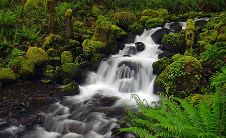
How to visit Wahclella Falls

Though hardly a secret anymore , the hike to Wahclella Falls remains a less traveled alternative to other short waterfall hikes in the Gorge. The trail is generally open year-round, though the best times for photography are in May/June, when spring greenery is at its peak, and in late October, when the bigleaf maples light up the forest with bright yellow and orange hues.

[Click here for a larger, printable version of this map]

This is a terrific family trail, thanks to several dramatic footbridges, two waterfalls, a staircase, caves (!) and several streamside spots safe for wading or skipping stones. Young kids should be kept close, however, since there are also some steep drop offs along sections of the trail. For kids, midweek in midsummer is a perfect time to visit.

Another fascinating time to visit with kids is during the fall spawning season, when the stream below the hatchery diversion dam is filled with returning salmon and steelhead within easy view of the trail.

Wahclella Falls is a family favorite

The trailhead for Wahclella Falls is easy to find. Follow I-84 east from Portland to Bonneville Dam (Exit 40), turning right at the first stop sign then immediately right into the trailhead parking area along Tanner Creek, where a Northwest Forest Pass is required. Portable toilets are provided at the trailhead from spring through early fall.

The trail begins at a gate at the south end of the parking area, and initially follows a rustic gavel road to a small diversion dam that provides water for the Bonneville Fish Hatchery. From here, the route crosses a footbridge in front of Munra Falls, and becomes a proper hiking path. Head right (downhill) at a fork in the trail 0.7 miles from the trailhead to begin the loop through the towering amphitheater surrounding Wahclella Falls, then retrace your steps 0.7 miles to the trailhead after completing the 0.6 mile loop portion of the trail. Enjoy!

After the Dollar Lake Fire

The Dollar Lake Fire from Bald Butte on September 3, 2011

On August 26, 2011, a lightning strike ignited what was to become the Dollar Lake Fire, on Mount Hood’s rugged north side. The fire started in the Coe Branch canyon, just below the Elk Cove trail, and was spotted by numerous hikers.

Initially, it seemed small and manageable. But over the next few days and weeks, arid conditions and strong winds spread the fire from Stranahan Ridge on the east to Cathedral Ridge on the northwest side of the mountain, eventually consuming some 6,300 acres of high elevation forest. The blaze burned through September and into early October, when fall rains finally arrived.

Hot spot erupts along Stranahan Ridge on September 3, 2011

Some of the burn was of the beneficial form, a mosaic fire leaving islands of surviving trees, but much of the fire was too hot and the accumulated forest fuel too plentiful to prevent devastating crown fires from sweeping across the forest. Eventually, the fire destroyed most of the standing timber and burned the forest duff down to mineral soil throughout most of the burn area.

The fire was contained entirely within the Mount Hood Wilderness, thanks to the recent Clear Branch additions that expanded the wilderness boundary on the north to encompass the Clear Branch valley and the high country surrounding Owl Point, to the north. While this complicated fire fighting, it has also created a living laboratory for forest recovery, as the USFS is unlikely to assist the reforestation process inside the wilderness boundary. The Forest Service map, below, shows the broad extent of the fire.

Final extent of the Dollar Lake Fire (outlined in red)

Though the fire burned to the tree line in several spots, a surprising amount of terrain along the iconic Timberline Trail was somehow spared. While the burn touched Elk Cove and Cairn Basin, WyEast Basin and Barrett Spur are well beyond the burned area. The Clear Branch wilderness additions to the north were mostly spared, as well.

The New Vista Ridge: After the Fire

The following is a photo essay from my first visit to the burn, on June 22, 2012, and is the first in what will eventually be a series of articles on the aftermath of the fire.

The devastation left by the fire is awesome to witness, but also starkly beautiful when you consider the context of a forest fire. After all, this event is part of the natural rhythm of the forest just as much as the changing of seasons.

From this point forward, we will have a front-row seat to the miracle of life returning to the fire zone, much as we’ve watched life return to the Mount St. Helens blast zone over the past 32 years. And as my photos show, the rebirth of the forest ecosystem has already begun on Mount Hood’s northern slopes.

Untouched trailhead at Vista Ridge.

From the Vista Ridge trailhead, I followed the Vista Ridge Trail to the snow line, above about 5,000 feet. The Vista Ridge trailhead is completely untouched, though the fire swept through a vast area immediately to the south. Yet, no sign of the fire is evident at the trailhead marker (above).

A bit further up the trail, at the Old Vista Ridge trailhead, the fire zone comes into view. Where green forests existed last summer, browned foliage and a burned forest floor spread out east of the junction. This fringe of the fire is of the healthy “mosaic” form, sparing large trees, while clearing accumulated forest debris.

Old Vista Ridge trailhead spared by fire… just barely.

An unexpected benefit of the fire came last fall, when the USFS added the long-neglected Old Vista Ridge trail to official agency fire maps (below) released to the public. Volunteers began restoring this beautiful trail in 2007, but formal acknowledgement of the route on USFS maps is a welcome development.

Welcome development: Old Vista Ridge trail reappears on USFS fire fighting maps

Clearly, the restoration of the Old Vista Ridge trail helped fire fighters reach this area, and could have served as a fire line had the blaze swept north, across the Clear Branch. Hopefully this is an indication that the Old Vista Ridge trail will someday reappear on the USFS maintenance schedule, too.

Turning south on the Vista Ridge trail from the Old Vista Ridge junction, the wilderness registration box and map board seem to have received divine intervention from the fire — the blaze burned within a few feet of the signs, yet spared both. From here, the Vista Ridge trail abruptly leaves the scorched fringe of the fire, and heads into the most devastated areas.

Vista Ridge trail signs were spared… by divine guidance?

A few yards up the Vista Ridge trail, the devastation quickly intensifies.

From about the 4,700 foot level, the Dollar Lake Fire burned the forests along Vista Ridge to bare earth. In this area, the entire forest crowned, leaving only a scattering of surviving trees where protected by topography or sheer luck. Forest understory, woody debris and duff burned to mineral soil, leaving a slick, muddy surface of ash. For those who have hiked through the previous Bluegrass Fire or Gnarl Fire zones on the east slopes of Mount Hood, this eerie scene is familiar.

The surprisingly intact trail curves through the devastated forests along Vista Ridge.

Crown fires have killed almost all of the standing forests along Vista Ridge.

Amid the devastation in this hottest part of the Dollar Lake Fire, signs of life are already emerging. At this elevation, one of the toughest survivors is beargrass, a member of the lily family with a deep rhizome that allows plants to survive even the hottest fires. These plants are normally evergreen, but were completely scorched in the fire. The new grown in this photo (below) has emerged this spring.

Beargrass (Xerophyllum tenax) emerges from underground rhizomes protected from the fire.

Another surprise is avalanche lily, one of the more delicate flowers in the subalpine ecosystem. Like beargrass, these plants survive thanks to a bulb located deep enough in the soil to escape the heat of the fire. As one of the early bloomers in the mountain forests, these plants area already forming bright green carpets in the sea of fire devastation (below).

Avalanche Lily (Erythronium grandiflorum) emerging from the ashes.

A ribbon of green, these Avalanche Lilies are emerging along the Vista Ridge trail.

Another of the beneficial aspects of the fire comes into view a bit further up the trail: several sections of Vista Ridge had long been overgrown with thickets of overcrowded, stressed trees that were ripe for a burn.

Over the coming years, these areas are likely to evolve into beargrass and huckleberry meadows like those found at nearby Owl Point or along Zigzag Mountain, where fires have opened the landscape to sun-loving, early succession plants.

Unhealthy forest thickets cleared by fire — a beneficial outcome of the blaze.

One human artifact was uncovered by firefighters — a coil of what must be telephone cable (below). This is a first along the Vista Ridge trail, but makes sense given the insulators and cable found along the Old Vista Ridge trail.

It’s hard to know what this connected to, but on the north end, it served the old Perry Lake Guard Station and lookout, just east of Owl Point. It’s possible this line extended to the Bald Mountain lookout, though I have been unable to verify this on historic forest maps.

Telephone cable on Vista Ridge – gathered up and coiled by firefighters?

Though much of the devastation zone still consists of blackened trees and soil, some of the burned forest has begun to evolve into the uniquely attractive second phase. This happens when scorched bark peels away from trees to reveal the often beautiful, unburned wood beneath.

Soon, all of the trees in this forest will shed their bark. The skeletons of thousands of trees will emerge in colors of red, yellow and tan, then gradually fade to a bleached gray and white with time.

The burned trees of Vista Ridge are just beginning to shed their blackened bark, revealing beautiful trunks unscarred by the fire.

Mount Hood rises behind the new ghost forests of Vista Ridge

This second phase of the fire is helped along by winter snow. As the scene above shows, the freeze-thaw and compacting effects of the snow pack have already stripped many trees of their bark beneath the now-melted snowpack. Hot summer sun will continue this process, shrinking the remaining bark until it drops from the drying tree trunk.

This process of de-barking is the first in a post-fire sequence of events that will recycle much-needed organic matter to the forest floor. Twigs and tree limbs will soon fall, and over time, whole trees will begin to drop. This is a critical phase in stabilizing the forest soil, when low vegetation is still just beginning to re-establish in the fire zone.

Strips of tree bark are the first organic layer to accumulate on the floor of the burn zone.

The next few images show the extent of the Dollar Lake Fire, as viewed from Vista Ridge. To the east (below), The Pinnacle was mostly burned, but the fire somehow missed stand of trees just below the north summit.

These trees will play an important role in reforestation of the area, partly because so few trees survived the fire, but also because of their geographic location above the surrounding forest, where wind will widely scatter their seeds.

The Pinnacle, where a small grove of of trees on the north slope survived the fire.

To the south, the area above Elk Cove known as 99 Ridge (shown below) was partly spared, though the fire did scorch the east slopes of the ridge. From this side (to the west), the Timberline Trail corridor was almost completely spared. Ironically, Dollar Lake — the namesake for the fire — appears to have been spared, as well.

To the west of 99 Ridge, WyEast Basin was also spared, but the area along the Timberline Trail to the west of the basin, along the upper sections of Vista Ridge, was largely burned.

Forests along 99 Ridge were spared by the fire.

This panoramic view (below) encompasses the entire mid-section of the fire, from Stranahan Ridge on the horizon to Vista Ridge, on the right. This is a new viewpoint along a largely unnoticed rocky scarp on the east shoulder of Vista Ridge, now revealed thanks to the fire.

(Click here for a much larger panoramic view]

A Changed Landscape

Those who have explored Mount Hood’s north slopes over the years will surely mourn the loss of the beautiful forests of noble fir and mountain hemlock that once stood here — I certainly have. But this is also a chance to watch the ecosystem recover and restore itself over time, as it has for centuries. Among the surprising benefits are the new scenic vistas that are suddenly available, giving a bit more meaning to the name “Vista Ridge.”

The new views from Vista Ridge include Laurance Lake and Bald Butte, to the east.

By following the true ridge top of Vista Ridge, the new views extend east across Laurance Lake and the Clear Branch valley to Bald Butte and the Columbia Basin (above). Most of the area below the ridge is not burned, and this new perspective on the recent additions to the Mount Hood Wilderness is both unexpected and beautiful.

To the north, the new views include the rugged and little-known Owl Point area of the expanded Mount Hood Wilderness (reached by the Old Vista Ridge trail). Mount Adams rises in the distance, above the talus fields and meadows of Owl Point.

Owl Point and Mount Adams from newly revealed viewpoint on Vista Ridge.

This suddenly very scenic “true” ridge along the lower portion of Vista Ridge is easy enough to hike by simply following the ridge top where the existing trail heads into a narrow draw, about one-half mile from the Old Vista Ridge trail junction. It’s worth the visit if you’d like to inspect the scenery and Dollar Lake Fire up-close.

But in the spirit of recasting the Vista Ridge trail in the aftermath of the fire, and taking in these new views, now would be the perfect time to simply realign the trail along the ridge top. As shown on the map (below), this project could be done in a weekend by volunteers, if approved by the Forest Service.

(Click here for a larger map]

The fire has already done the heavy work of trail building by clearing the ground to mineral soil: designing and completing a realigned trail here would be quite straightforward. The slope of the ridge top, itself, is surprisingly gentle and would allow for an easy grade, similar to the current trail.

I hope to pitch this idea to the Forest Service, so if you’re interested in getting involved, watch the Portland Hikers forum for updates. That’s where volunteer work parties will be organized if there is interest from the USFS.

Until then, take the time to explore the fire zone, and watch the unfolding forest recovery firsthand. Visit the Portland Hikers Field Guide for directions to the Vista Ridge Trailhead.

Proposal: Waucoma Bicycle Backcountry

It’s no secret that mountain bikes have been relegated to second-class status when it comes to recreation trails. They’re not allowed in designated wilderness areas, and even with the special set-asides for mountain bikes called out in the recent Mount Hood Wilderness additions, the trail options around the mountain are limited.

It’s also true that bikes and hikers don’t always mix well. Since I’m both a hiker and cyclist, I’m probably more comfortable than most hikers when it comes to shared trails. I love to hike and bike the Surveyor’s Ridge Trail, for example, but most hikers shy away because of its popularity among mountain bikers.

The view toward Mount Hood from Blowdown Mountain

This article is a proposal for something a little different for mountain bikers: the concept is to convert fading logging roads in a scenic area directly adjacent to the Mark O. Hatfield Wilderness to become a dedicated bicycle backcountry. In addition to providing an exciting set of mountain biking trails, the concept would specifically allow for bikepacking — overnight camping at a several destinations that would be bike-in, only.

Most importantly, this new destination would be close to both Portland and the mountain biking hub of Hood River, where bicycle tourism has become an important part of the recreation economy.

[click here for a large, printable map]

The best part of this proposal is that it wouldn’t take much to put the network together. Converting fading roads and constructing just 2.9 miles of new trail (shown in yellow on the map, above) would create a 25-mile bike network of bike-only trails (shown in blue) in an area with terrific scenery, creating as close to a wilderness experience as you can have while on two wheels.

The Proposal

The proposed bicycle backcountry would straddle the high country along Waucoma Ridge, about ten miles due north of Mount Hood. Two main trailheads would serve the backcountry: a new trailhead would be constructed in the headwaters valley of Divers Creek, serving as the primary entry into the bicycle backcountry. The existing Wahtum Lake trailhead would serve as overflow. Both are accessed on paved roads. A third, more remote trailhead would be located at the headwaters of Green Point Creek, accessed by a primitive road.

The view toward Indian Mountain from Waucoma Ridge

Trails

The proposed network has three kinds of bicycle facilities: converted logging roads (dashed blue on the map) functioning as single or dual track routes, new single track bike trails (dashed yellow) and striped bikeways (solid blue) on a short segment of paved Wahtum Lake Road that serves as a critical connection in the proposed network.

The focus of the network is on bicycle loop tours. From the proposed new trailhead, dozens of tour variations are possible, thanks to the dense network of old roads in this area, and the potential to connect and convert them. One out-and-back trail exists, following the Waucoma Road to Indian Mountain (under this proposal, the road would be gated to motor vehicles at the Wahtum Lake trailhead)

Washington’s big volcanoes fill the skyline on the slopes of Indian Mountain

The main focus of the new trail system would be Blowdown Mountain, a surprisingly rugged shield volcano whose gentle summit ridge belies a rugged east face, featuring a craggy volcanic plug rising above a series of forested glacial cirques. An attractive spur road traverses the entire summit ridge of Blowdown Mountain, and would form the spine of the trail network in this part of the bicycle backcountry.

Three small lakes are located in glacial cirques on the northeast flank of the mountain, and views from the high ridges include nearby Mount Hood, to the south, and the high peaks of the Hatfield Wilderness, to the north. The big Washington State volcanoes complete the scene on the northern skyline.

Spring wildflowers line the rustic route Indianhead Ridge with Mount Hood in the distance

The western part of the proposed network focuses on Indianhead Ridge, another high shoulder of the Waucoma Ridge complex, extending south toward the West Fork Hood River. The proposed trail network in this section would include extensive ridge top rides, with panoramic views of Mount Hood and the steep east face of Indian Mountain.

This part of the bicycle backcountry would also encompass the Waucoma Ridge Road, gating and converting the route to bike-only use except for Forest Service vehicles. The road leads through exceptionally scenic terrain, including the former lookout site on Indian Mountain, and fine views into the Eagle Creek valley, within the Hatfield Wilderness. The road, itself, forms the Hatfield Wilderness boundary.

Beautiful Scout Lake in the proposed Waucoma bicycle backcountry

This section of the proposal network also includes seldom-visited Scout Lake, a beautiful forest lake that has historically been stocked with brook trout by the Oregon Department of Fish and Wildlife (ODFW).

Campsites

Five bikepacking campsites are proposed along the new trail circuit. One is simply the existing Indian Springs Campground, an excellent but largely forgotten primitive campground in need of repair. New campsites would be located at Ottertail Lake, the Talus Pond near Gray Butte, Mosquito Lake and Scout Lake, with each offering 5-15 tent sites.

Unlike the nearby Hatfield Wilderness, bikepacking campsites in the new backcountry would feature rustic picnic tables, fire rings and secure hitching racks for bicycles — features that aren’t allowed in a wilderness area, but would be welcome additions in the bicycle backcountry.

Mosquito Lake basin from Blowdown Mountain, with Mt. Defiance and Mt. Adams in the distance

What would it take?

The viability of this proposal is in its simplicity: less than three miles of new trail would open a 25-mile network, with dozens of loop options that could be tailored to the ability of individual mountain bikers. Most of the work required could be done with the help of volunteers, from trail building and campsite development to signage and ongoing maintenance. Some heavy equipment would be required to develop the new, main trailhead and decommission vehicle access to converted roads.

The view across Ottertail Lake basin toward Tomlike Mountain and Mt. St. Helens

Of course, the proposal would also require the Mount Hood National Forest (MHNF) to fully devote the Waucoma Ridge area to quiet recreation. A few years ago, that would have been unlikely, but in recent years, the agency has not only adopted plans to phase out hundreds of miles of logging roads, but also a policy to focus OHV use in a few, very specific areas of the forest. The recent developments could move this proposal into the realm of the possible if sufficient support exists for a bicycle backcountry.

It would take dedicated support from the mountain biking community to make the case to the Forest Service, ideally in a partnership with the agency that would include volunteer support in developing the trail system.

Cyclist on the new Sandy Ridge trail system, an example of collaboration between the USFS and bicycle advocates (City of Sandy)

The good news is that mountain bicycling organizations are already working hard to develop trails elsewhere in the Mount Hood region (such as the Sandy Ridge trail complex, pictured above) and hopefully would find this proposal worth pursuing. If you’re a mountain biker, you can do your part by forwarding this article to like-minded enthusiasts, or your favorite mountain biking organization. It’s a great project just looking for a champion!
____________

Bikepacking Resources

Bikepacking.net is an online community that focuses on off-road touring, away from cars, with great information on gear, routes and trip planning.

The Adventure Cycling Association posted this helpful article on how to pack for your bikepack trip.

Another good article on what to pack for your bikepack on the WhileOutRiding.com blog.

The International Mountain Bicycling Association is the premier organization and advocate for backcountry bicycling.

In the Mount Hood region, the Northwest Trail Alliance is the IMBA Chapter doing the heavy-lifting on bicycle trail advocacy.

Starvation Creek Loop Hike

Cabin Creek Falls

This blog has featured a series of articles on restoration of the former (and future!) Warren Falls, located in the Starvation Creek area. But there is a lot more to see in this interesting and less-traveled corner of the Columbia River Gorge, and this loop hike explores an amazing variety of scenery on a short, but demanding circuit.

Along this way, you’ll see four waterfalls, one “dormant” waterfall, ford two creeks, visit hanging meadows, peer over the brink of some truly breathtaking cliffs and enjoy expansive views of the Columbia River Gorge. You’ll want to print the large version of the trail map, below, as the trail network in the area is dense, and trail signage unreliable.

[click here for a larger, printable trail map]

The hike is best done from late April through early November, as the conditions can be somewhat treacherous in icy winter conditions, and the stream fords difficult in winter and early spring. But for adventurous hikers, this loop is generally open year-round, and provides a nice hiking option when snow covers the high country.

Hiker’s grim warning on a temporary sign at the Starvation Ridge Cutoff Trail..!

Note that the loop described here follows a specific direction, tackling the very steep Starvation Ridge Cutoff Trail first, in the uphill direction. This might seem counter-intuitive, but the steepness of this path is much harder on your knees going down than on your lungs and legs going up — and it can feel a bit slick and sketchy to descend, due to the steepness and exposure.

The Hike

The trail begins at the Starvation Creek Trailhead (directions at the end of this article). Head west from the parking area, walking parallel to the freeway exit, then drop into the trees following a section of the old Columbia River Highway. ODOT will soon be restoring this section of highway as part of a state recreation trail, so watch for construction to begin soon.

The welcome signpost marking the top of the Starvation Ridge Cutoff Trail

A short distance from the trailhead, you’ll see a signboard on the left marking the Starvation Ridge Cutoff Trail No. 414B (if you reach Cabin Creek Falls, you’ve gone too far). Take a deep breath, and begin the stiff climb up this trail, as it threads its way in a series of switchbacks through the towering cliffs that frame the Starvation Creek area.

Soon, the trail curves into the upper canyon of Cabin Creek, leaving the sounds of the freeway behind, and continuing steeply above the creek into dense forest until you reach the signpost marking the upper junction with the Starvation Ridge Trial No. 414.

The dizzying view of the trailhead from the top of the Cutoff Trail

The main loop heads to the right (west), and crosses Cabin Creek. But before you continue in that direction, make a brief detour to the left (east), following the Starvation Ridge Trail uphill for about 200 yards to a spectacular cliff-top viewpoint, a few feet off the trail. From here, you can peer a dizzying 500 vertical feet down to the trailhead and the tiny cars, trucks and freight trains moving below.

Looking west toward Shellrock Mountain and Wind Mountain from the Cabin Creek viewpoint

After resting your legs (and lungs) from the Starvation Cutoff trail, and enjoying the sweeping view from the overlook, retrace your steps back to the junction, and continue west on Trail 414, fording Cabin Creek. From here, the route climbs from the Cabin Creek canyon in a series of short, well-graded switchbacks, and passes another towering cliff-top viewpoint on the right.

The trail soon crests a divide marked by a 1930s-vintage transmission tower, and descends into Warren Creek canyon in a series of switchbacks traversing an enormous hanging meadow. In late April and May, the meadow features beautiful displays of shooting star and other wildflowers, but offers stunning views any time of year.

Shooting Star in the hanging meadow above Warren Creek

Great Hounds Tongue near Cabin Creek

Soon, the trail re-enters forest, then reaches Warren Creek, a potentially difficult ford in winter and early spring. There’s no bridge here, so cross carefully. Warren Creek is the stream that once flowed over Warren Falls, just downstream from the ford. Since 1939 it has been diverted through an odd bypass tunnel that now forms manmade “Hole-in-the-Wall Falls”. You’ll pass both later on the hike.

From Warren Creek, the trail makes a gentle traverse along the forested canyon wall, then turns and crests another ridge below a second transmission tower, before descending across another open area with terrific views of the Columbia River Gorge.

The trail passes this mossy, cliff-top rock garden near Warren Creek

The view west from the Warren Creek viewpoint

The trail now descends to a 3-way junction of the Starvation Ridge (No. 414) and Mount Defiance (No. 413) trails, poorly marked with a very old signpost. From here, the loop hike continues to the right, turning steeply downhill. But first, go straight 200 yards to beautiful Lancaster Falls on Wonder Creek. This magnificent waterfall is named for Samuel Lancaster, the visionary engineer who designed the Historic Columbia River Highway.

Lower, trailside tier of Lancaster Falls

The best trailside view of Lancaster Falls is from the west bank, so be sure to rock-hop your way across. From there, you can also see part of the tall, lacy main tier of this beautiful waterfall (if you’re feeling really adventurous, it’s possible to scramble to a close-up view of the upper tier by heading uphill from the trail, just east of Wonder Creek).

After cooling off at Lancaster Falls, backtrack to the 3-way junction, and rejoin on the Starvation Ridge Trail No. 414, heading left as it descends steeply across an open slope, soon reaching a sturdy, new footbridge over Warren Creek.

Part of the magnificent main tier of Lancaster Trails, located off-trail

You’ll have views of man-made Hole-in-the-Wall Falls from the bridge, but waterfall lovers should take a few minutes to follow the obvious boot path that parallels the dry streambed to the left of the falls.

This streambed leads to the original, natural location of Warren Creek Falls — the topic of several articles on this blog. The hauntingly quiet amphitheater of the original falls is eerie, and it’s easy to imagine the sound and spectacle that once existed when Warren Creek poured over this cascade. During the periods of heavy winter runoff, Warren Creek occasionally overtops the diversion tunnel, and briefly flows down its natural falls. If you look closely, you’ll see evidence of winter storm events that have briefly brought the original falls and streambed back to life.

Warren Falls flowing in one of its rare winter appearances in March 2012

After taking in the scene at the former Warren Falls, retrace your steps on the boot path to the footbridge and turn right, continuing along the main trail for your return to the trailhead (note: the restored Historic Columbia River Highway and trail will soon be constructed in this area, with a new trailhead for the Starvation Ridge Trail relocated to this spot).

The route briefly passes an open area, and then re-enters forest. Watch for old, stone foundations covered in ivy in this area — you’re passing turn-of-the-century homesteads lost to time. Sharp-eyed hikers will also spot a pair of enormous anthills, each measuring six feet in height. A bit further, and you’ll also pass dome-shaped stone bake ovens, possibly built in the early 1900s by highway workers (see the map below for help in finding these traces of human history in the Warren Falls area).

[click here for a larger, printable map]

Finally, the trail rejoins the abandoned section of the old highway, following it to lovely Cabin Creek Falls. Photographers should take a moment to walk the short boot path to the base of the falls to capture the exceptionally beautiful scene. Crane your neck upward, and you will see the huge cliffs to the left of the falls that you skirted above on the Starvation Ridge Cutoff Trail!

To complete your journey, continue along the old highway grade back to the trailhead. A great way to end this hike is with a final stop at magnificent Starvation Creek Falls, the star attraction in this part of the Gorge. To reach the falls, head past the restrooms, and take the spur trail on the right. A string of streamside picnic tables make this an idyllic spot to relax after your hike, and enjoy a picnic lunch.

Misty base of Starvation Creek Falls

Hike Logistics

The usual Columbia River Gorge precautions apply on this hike: you’ll find poison oak, ticks and sheer cliffs, so it’s not a great choice for kids. If you’re bringing small kids on this hike, consider just hiking the lower portion to Lancaster Falls, where they will have plenty to enjoy without steep trails or dangerous exposure.

The steepness of the hike makes it a good candidate for cool weather, too. Hiking poles are especially helpful, and dogs should be leashed on this trail.

Getting there

The trailhead is at the Starvation Creek rest area, located at Exit 55 on I-84, about an hour east of Portland. The trailhead has water and restrooms, and no trailhead permit is required. The Starvation Creek exit is eastbound-only, so to return to Portland, you’ll need to drive another mile east to the Viento State Park exit, then follow the signs west to Portland.

For information on the Historic Columbia River Highway restoration project, check out the ODOT website, and click on “ongoing projects” for construction updates:

Historic Columbia River Highway Project

Visit Restore Warren Falls! on Facebook for more information on the project.

10 Common Poison Oak Myths

Spring in the Columbia River Gorge brings lush greens and a rainbow of wildflowers, but in this heavenly mix you will also find Toxicodendron diversilobum: Western poison oak.

If humans were as immune to the toxic oils of this plant as deer seem to be (they snack on the stuff!), we would simply admire it for the handsome foliage, and maybe even grow it in our gardens. After all, poison oak is an undeniably handsome plant… from a distance.

But instead, humans are prone to contact dermatitis when we encounter poison oak up-close, breaking out in itchy, blistering rashes that can take weeks to subside. Folklore on the cause and remedies for poison oak rash abound, and much of the information in this age of the internet is decidedly misleading.

Handsome devil: poison oak is as toxic as it is elegant.

Here are 10 common myths about poison oak — debunked — with information every hiker should know about this pesky plant:

Myth 1 – Many people are simply immune. I have hiked the poison oak-lined trails of the Columbia Gorge since the age of five, and thus have a 45-year streak of never reacting to it, despite some epic encounters. Am I immune? Maybe, but it turns out only about one-in-ten seem to have no reaction poison oak. Most of us who think we are immune have simply been careful enough — and lucky. If you have a perfect track record, assume it’s your reward for due caution, not immunity.

Myth 2 – Only the sap is toxic. Some believe it takes breaking a stem or crushing the leaves to release the toxic component of poison oak, a chemical called “urushiol” (pronounced “yoo-ROO-she-all”), and that simply brushing against it cannot transmit the toxin to your skin. In fact, urushiol is present throughout the plant, including the surface oils on the leaves and green stems of poision oak. This is especially true in spring, when new foliage literally glistens with toxic oils.

Poison oak usually looks like this in the Gorge: a spreading groundcover, 1-3 feet deep, and favoring open woods and forest margins.

Myth 3 – You’ll know you’ve got it by the next morning. While it takes only about 30 minutes for urushiol to penetrate your skin, the itchy, blistering skin reaction does not appear immediately. For most people, the symptoms are delayed at least 12 hours after exposure, and it usually takes up to 3 days for symptoms to appear — confounding hikers who think they’ve escaped a close encounter without consequence. For a first time sufferer, it generally takes even longer for the rash to appear – as much as 7 to 10 days!

Myth 4 – It takes a lot of exposure to cause a reaction. Poison oak is surprisingly toxic, and only a small amount of exposure can trigger a reaction. A single drop of urushiol on your skin contains more than enough toxin to cause a reaction, and a small amount is easily spread across your skin by perspiration or physical contact while you hike.

Myth 5 – Scratching will spread your rash. Scratching or rubbing a poison oak rash won’t make it spread to other parts of your body, assuming you’ve already washed thoroughly with soap and water. You can spread the rash if urushiol oil is still on your skin, of course. Scratching can lead to secondary skin infections, however, making your itchy misery a bit worse.

Poison oak is versatile, growing as a ground cover, shrub, or as a towering vine, as in this nightmarish scene along the McCord Creek trail.

Myth 6 – Breaking blisters will spread the rash. Breaking blisters won’t spread poison oak to other parts of your body, or other people. But open blisters can become infected and you may cause permanent scarring in the process. In very extreme cases, excessive fluid may need to be withdrawn by a doctor, though in most cases it’s best to simply let blisters heal on their own.

Myth 7 – Dead or leafless plants aren’t toxic. The bare winter stems of poison oak may look harmless, but still contain toxins. Urushiol oil has lasting power, and can stay active on any surface, including dead plants, for up to 5 years. Burning dead or dormant poison oak branches is an especially dangerous practice, as urushiol oils released in smoke can produce disastrous results, if inhaled.

Myth 8 – Dogs can’t get poison oak. Dogs are mostly protected from poison oak by their fur, though some can develop symptoms on their nose or underbelly. But all dogs can accumulate the oils on their fur, and transmit it to unwitting owners. This is especially true for off-leash dogs that might find a lush patch of poison oak just off the trail, but unseen by the dog’s owner.

The safest practice is to simply keep dogs on a leash when in poison oak country, so you know where they’ve been. Even better, give them a shampoo after the trip, as a precaution — or consider leaving Fido behind when you know you’re going to be in prolific poison oak country.

Poison oak growing in shrub form along the Rowena Plateau trail, showing the handsome bronze color of emerging leaves in spring — when the plant is especially toxic.

Myth 9 – You can develop immunity from exposure. False. With some 90% of humans allergic to urushiol, it’s only a matter of time before most of us will develop a reaction, and it turns out the more reactions you experience from exposure to urushiol, the more likely you are to react to with further exposure. But the reverse is also true: avoiding exposure (and outbreaks) reduces your susceptibility to a reaction. In other words, the myth has it backward: your best immunity comes from simply avoiding contact to begin with.

Sadly, the “develop your immunity” myth is among the more dangerous notions circulating on the internet, with countless testimonials on the “homeopathic” benefits of actually eating poison oak leaves in order to develop immunity. This is an incredibly foolhardy, dangerous idea that can lead to serious, life-threatening situations. Don’t even think about it!

Myth 10 – It’s just a rash. For most of us, this is true. But given the delayed (and varied) symptoms, poison oak reaction should always be taken seriously. As with any immune response to toxins, the symptoms can sometimes spiral out of control and become deadly. If you have a serious reaction, you need to see a doctor right away. Here are the American Academy of Dermatology guidelines for knowing if you’re having serious reaction:

• You should see a doctor if swelling persists, specially swelling that makes an eye swell shut or your face to swell.

• You should see a doctor if the rash covers a large part of your body, you have large blisters, or cannot sleep.

• If you have trouble breathing or swallowing, immediately go to an emergency room.

So, you’ve developed a rash from poison oak exposure, and it isn’t serious? Then you can treat it yourself. You can try one of these online resources for tips on managing your itchy journey ahead:

American Academy of Dermatology

Mayo Clinic

There are dozens of resources on the giving medical advice on treating poison oak rash, many with undocumented, anecdotal suggestions, so the best bet is to stick with these, or similarly respected clinical sources.

This impressive poison oak patch in the Viento area shows all three forms of the plant: groundcover, shrub and as a vine, climbing up the tree trunks.

Managing your Poison Oak exposure

The following hiking tips are adapted from recommendations by the American Academy of Dermatology and Mayo Clinic:

During your hike in poison oak country:

• If you are very sensitive, or heading into a lot of poison oak, consider one of the topical skin products containing bentoquatam, a non-prescription compound shown to protect the skin from absorbing urushiol.

• Wear long pants, long sleeves, boots, and gloves. Even when you apply a skin barrier that contains bentoquatam, you still need to cover your skin with clothing.

• Use hiking poles. They have the effect of keeping your hands up and in front of you, where you’re less likely to brush against poison oak.

• Keep your hands and arms away from your face.

• Rinse your skin right away with lukewarm water if you think you’ve been exposed. You may be able to rinse off the oil before the urushiol penetrates your skin.

Another view of an impressive patch of poison oak in the Viento area, growing in open Douglas fir forest.

After your hike in poison oak country:

• Take a shower — not a bath — with plenty of soap and lather.

• Wash all of the clothes you were wearing when you came into contact with poison oak with conventional laundry soap, set for two rinse cycles (if possible).

• Wash or wipe anything that may have urushiol oil on its surface with soap, including hiking poles, leashes, and your pet.

• Some hikers swear by Tecnu, an over-the-counter topical treatment for removing urushiol oils. Clinical tests show it to be somewhat more effective than plain soap, though neither a substitute for avoiding contact to begin with.

Learning to Recognize Poison Oak

Poison oak is easy to recognize: the old adage “leaves of three, let it be” applies, as poison oak generally has three leaflets per stem. With a bit of practice, you can learn to instantly recognize it as you hike, including the leafless stems in winter.

Here’s a close-up of the classic leaf shape (below), somewhat resembling an oak leaf, but with less pronounced lobes. In autumn, poison oak leaves take on striking hues of red and coral before dropping, leaving bare stems in winter. Note the tiny blossoms in the background — in summer, these will become clusters of greenish-white or tan berries.

Poison oak leaf detail: “Leaves of three, let it be..!”

Poison oak has several friends that it often grows with, and these plants can sometimes be confused with the real thing. They’re worth learning to identify, too, partly to know if you’ve been exposed to the real thing — but also because when you see these companion plants, you’re likely to be in poison oak habitat, and can keep an eye out for the genuine article.

One obvious example of a look-alike is the Oregon white oak (below), a classic companion of poison oak, and easily confused where brushy thickets of white oak grow in the eastern Columbia Gorge. Oak leaves are single, however, and usually larger with much deeper lobes than poison oak.

Oregon white oak can be confused with poison oak in the oak savannah country of the eastern Columbia River Gorge (courtesy PCC)

Another companion plant that is somewhat less common, but matches the “leaves of three” identifier is wild blackberry, or bramble (below). These plants are easily identified by their thorny, rambling stems that creep through the forest, small thorns on the underside of the leaves, and edible (and tasty) blackberries that form in summer.

Wild blackberry, or bramble, has “leaflets of three”, but is thorny, not smooth.

Still another companion plant that can be confused with poison oak is ocean spray, which prefers the same open woodland and forest margin habitat that poison oak enjoys. However, its leaves are single, and generally smaller than poison oak.

Ocean spray grows in dense clumps of arching stems, often reaching 8-10 feet in height. The name comes from “sprays” of hundreds of tiny, white blossoms in large clusters that cover plants in summer.

The leaves of ocean spray might initially look like poison oak, but are single and grow from a tall, arching thicket and have dramatic clusters of tiny white blossoms that give the plant its name.

Finally, snowberry is a companion plant of poison oak that normally has small, oval leaves, but in early spring grows larger, lobed leaves that can resemble poison oak at first glance. Snowberry can be identified by its thin, twiggy stems and white, inedible berries that give the plant its name. Most of its leaves are oval, and finely toothed, not lobed.

Early spring leaves on new growth are often exaggerated on snowberry, and can sometimes look like poison oak. The white berries on this plant distinguish it from the poison oak, and give the plant its name. In this view, the more typical oval leaves can bee seen in the background.

Where is Poison Oak Country?

Where can you expect to encounter poison oak? The answer is anywhere you might hike in the Gorge below an elevation of about 2,000 feet. It grows along most low-elevation trails throughout the Gorge, from Angels Rest on the west end to Dalles Mountain Ranch on the east.

Though the most prolific displays are east of Cascade Locks, you will find also lush bowers of poison oak draped over the rustic stone walls at Wahkeena Falls and Multnomah Falls, and along many sections of the popular Eagle Creek Trail (for Clackamas River hikers, it also grows in the lower canyon, under similar conditions).

Poison oak in early spring: new growth emerges in beautiful shades of copper, crimson and gold… though best appreciated from a distance!

The best bet is to assume its presence whenever hiking in the Gorge, and follow the simple precautions described in this article. It doesn’t have to ruin your hike: learning to recognize poison oak in its various forms is peace of mind, as you’ll be able to watch for it and manage your exposure with the knowledge that you know what you’re watching for.

Finally, if you’ve got small kids, there is no better way to teach them about plants than to start with identifying (and not touching!) poison oak. Print these photos of the plant (shown earlier in this article) for them to fold up and carry in a plastic sandwich bag on your next family hike:

(click here for a general view of poison oak)

(click here for a detailed view of the leaves)

It’s a great opportunity to teach young hikers to understand and respect nature, not fear it — and that goes for us grown-up hikers, too!

“Warren Falls, we’re ready for your close-up…”

On May 12, Oregon Public Broadcasting’s popular Oregon Field Guide program travelled to the site of Warren Falls to film a story on the unique history of Warren Creek: the odd 1939 highway department project that silenced the falls, and the potential for restoring the falls to its former grandeur.

Michael Bendixen and Vince Patton on the chilly January trip to Warren Falls

This was the second trip to Warren Falls for Oregon Field Guide producer Vince Patton and videographer Michael Bendixen. Both had joined me for a first look at the area on a particularly icy January day last winter when the Gorge was at its worst — freezing rain and sleet over a crusty layer of snow.

Our May 12 trip would prove to be the welcome opposite: unseasonably warm, summerlike conditions, with trails lined with ferns and wildflowers instead of snow. Along for the trip were PortlandHikers.org friends Adam Sawyer and Jamie Chabot, and Kristen Stallman and Andy Johnson, representing the ODOT team that is steering the Historic Columbia River Highway restoration project.

(from left) Adam, me, Andy, Jamie, Kristen, Vince and Michael at the trailhead

We met at the Starvation Creek trailhead at 9 AM, and loaded up our packs with OPB gear before making the short hike to Warren Falls. Along the way, the OPB team shot a few trail scenes, but were interested in getting to Warren Falls and Hole-in-the-Wall Falls while the morning light lasted.

Vince and Michael working at the mighty basalt wall formed by Warren Falls

We soon reached the massive amphitheater created by Warren Falls, where the OPB crew filmed the haunting scene of the silenced waterfall, marked only by the trail of moss that marks where the waterfall once flowed. The group spent some time here discussing the strange project that diverted Warren Creek in 1939, and the mechanics of the diversion tunnel and accompany flume that has long since disappeared.

Warren Creek had overflowed Warren Falls several times over the course of our wet winter, and there were obvious signs that a large amount of water had coursed down the old streambed. But on this day, the stream was dry, with the eerie quiet that now exists here.

Michael filming at Hole-in-the-Wall Falls

We backtracked to Hole-in-the-Wall Falls for another session of shooting. Here, the rest of the group visited while Michael and Vince captured several angles of the odd, accidental waterfall.

Adam, Andy, Jamie & Kristen at Hole-in-the-Wall Falls

For a good look at the bypass tunnel that creates Hole-in-the-Wall Falls, we moved to the knoll above the footbridge. From this spot, it’s easy to imagine the wood flume that once attached to the tunnel exit and carried Warren Creek over the old highway and railroad, all the way to the Columbia River. Only when the old flume disappeared was today’s man-made falls created.

Pointing out the man-made features of the upper portion of Hole-in-the-Wall Falls

A wood flume originally connected to the tunnel opening, carrying Warren Creek over the old highway and to the Columbia

Next, we hiked up the Starvation Ridge Trail, heading for the brink of Warren Falls, and the huge steel weir at the head of the diversion tunnel.

The original plan was to scramble down Warren Creek from the Starvation Ridge Trail ford for the quarter mile of bushwhacking required to reach the brink of the falls. But Kristen had been to the diversion structure a few days earlier with an ODOT engineering crew, and they had found a faint boot path that dropped more directly from the Starvation Ridge Trail.

We voted on the two options at the Starvation Creek ford: wet feet and a rock hop along the stream or pushing through a hillside of poison oak along the boot path? The poison oak option won the day!

Weighing the alternative routes at the upper Warren Creek crossing

We backtracked to the jump-off point for the boot path, descended through a manageable patch of poison oak, and soon found ourselves curving around a steep, grassy bluff hanging directly above the 120-foot cliffs of Warren Falls.

From here, a dramatic view of the massive Warren Creek diversion structure suddenly came into view, and the OPB crew set up to shoot the scene.

Rounding the approach to the brink of Warren Falls

Michael shoots the diversion structure from the cliff top above Warren Falls

The diversion structure is much larger up-close than the historic drawings or a glimpse from below the falls would suggest. The tilted weir is made from sixty 20-foot steel beams laid across a 28-foot wide trench carved into the cliff. Beneath the mesh of steel rails, the trench leads directly to the bypass tunnel.

A close-up view reveals at least half the weir to be filled with loose rubble, to the extent that it is lush with a strange hanging garden of wildflowers, A thicket of willow has even become established in the upper right corner of the weir, suspended 15 feet above the diversion tunnel, below. The forces of nature are taking back Warren Creek Falls, slowly but surely.

Vince takes in the huge steel weir that covers the diversion tunnel opening, rushing directly below him

The up-close view also shows most of the beams to be twisted and buckled with the ravages of time, thanks to rocks and debris getting lodged between the beams, and the effects of freeze-thaw cycles in the harsh Gorge winters.

Still, the overall structure represents an amazing ingenuity of design and construction detail to have lasted 73 years, but is still functioning as intended. While nature is clearly winning this battle, the persistence of the diversion project is silent tribute to the designers and builders who created these structures in 1939.

Jamie exploring the steel weir from below — the top of Warren Falls is few feet beyond

Jamie peers through the weir into the opening of the diversion tunnel, directly below

Vince found an opening in the upper corner of the weir, and set up a compact camera mounted on a short arm to film the scene below

The OBP team used a compact video camera mounted on an arm to shoot under the weir. Vince found an opening at the upper west corner of the weir that gave access to the view from below the steel beams.

From this angle, Vince was shooting just below the upper edge of the weir, where a 15-foot rubble and masonry dam was constructed across the creek to elevate the angle of the weir structure toward Warren Falls. For 73 years, this design has allowed for loose debris to roll off the weir and over the natural falls, while filtering the waters of Warren Creek through the weir into the bypass tunnel that now forms Hole-in-the-Wall Falls.

Vince filming the tunnel below the weir with the compact camera

Next, we moved to the top of the weir, crossing to the upper east corner of the structure. The view from the top of the weir looking over the brink of Warren Falls is impressive, as is the view toward the Columbia River. From here, Dog Mountain fills the horizon across the river.

But the fact that the river can clearly be seen from the brink makes a good case that Warren Falls was one of the “four cascades caused by small streams falling from the mountainsides” in Captain William Clark’s journal entry of October 29, 1805. The other three were presumably the nearby falls on Starvation Creek, Cabin Creek and Lancaster Falls on Wonder Creek.

Looking down Warren Falls from the top of the weir

Dog Mountain dominates the view from the top of the Warren Creek diversion dam

The view from the top of the weir shows more wear and tear on the structure: the mortared lip of the rubble dam is badly weathered, fully exposing the ends of many of the 60 steel beams that connect to it, with only a rusty bolt anchoring them to the masonry wall.

Here, the decay of the diversion system seems to be moving close to structural failure — another argument for an orderly removal of the weir, and restoration of Warren Falls before it becomes impossible to safely do so.

Close-up of the top of the weir shows the wear-and-tear of 70 years

Vince and Michael planning the shoot from the top of the Warren Falls diversion dam

Jamie helps Michael set up at the top of the diversion structure

The group settled in for a lengthy shoot at the top of the falls, where Michael and Vince worked to capture the setting, and the rest of the group enjoyed the sylvan scene along Warren Creek.

Michael shooting from midstream, at the brink…

Michael posing for a certain Oregon Field Guide fan!

It’s a long drop: Michael shooting from the top of the diversion

The OPB crew wrapped up the day’s shooting with a few interviews and reflections of the group on the diversion project, and the future of Warren Falls. We soon packed up the video gear, and started up the canyon slope for the trail.

Adam shooting the OPB crew… shooting Warren Falls…

On the trip back to the trailhead, we ran into several groups of curious hikers, all familiar with Oregon Field Guide and excited to meet the crew.

One young woman asked what we were filming, and I explained the story to her — and asked her to go to Restore Warren Falls! on Facebook. Later, she approached me at the trailhead, and asked “Why are you focusing on this when there are so many global issues facing the world?”

Jamie muggles the geocache at Warren Falls. We signed it “Oregon Field Guide”

At the time I was somewhat startled, and replied that the project to restore the Historic Columbia River Highway provided a unique opportunity for funding the restoration of Warren Falls — a good argument, and one she seemed to accept. But I wish I’d simply said “We have to start somewhere, and right now, this is as good a place as any!”

“I wondered why somebody didn’t do something. Then I realized, I am somebody.”

~Author Unknown

(Special thanks to the Vince, Michael, Jamie, Adam, Andy and especially Kristen for another great day imagining the past and future Warren Falls)

___________________________
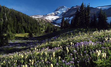
Previous articles on restoring Warren Falls:

Restoring Warren Falls
Warren Falls Lives! (temporarily, at least)
Warren Falls Mystery… Solved!
Warren Falls Solutions
Warren Falls Lives… Again?

Restore Warren Falls! on Facebook

Exploring Mitchell Point

Looking west into the Gorge from Mitchell Point.

If you find yourself overwhelmed by the crowds at Angels Rest, Mitchell Point in the east end of the Gorge is terrific alternative that offers equally stunning views, without the circus atmosphere.

Though the hike is just 2.6 miles round-trip, the elevation gain is around 1,000 vertical feet, thanks to an often steep path. But the unfolding scenery will distract you from the huffing and puffing required to reach the summit. Be sure to pick a sunny day for this hike, and if you make the trip from late April through early June, you’ll also be rewarded with a variety of wildflowers along the way.

An East Gorge Icon

Mitchell Point is unmistakable to travelers rushing by on I-84, rising dramatically from the forested Gorge slopes, just west of Hood River.

The main summit is a dizzying rocky spine towering 1,000 feet above the Columbia River and I-84. Below the main summit is Mitchell Spur, a tilted, ramp-shaped peak with a sheer cliff that rises nearly 400 feet above the highway. The Native American names for these prominent outcrops were Storm King (Mitchell Point) and Little Storm King (Mitchell Spur). The current name reportedly comes from an early trapper who lived in the area.

Mitchell Point from the west.

Like most of the rocky outcrops that frame the Columbia Gorge, Mitchell Point is composed of flood basalts — layers of dense lava spread over the region in the very distant geologic past. In this part of the Gorge, earth movements have tilted these ancient flows to the south at 30-degree angle. This tilt is most evident in Mitchell Spur, where exposed cliffs reveal the many layers of basalt that shape the terrain.

But it took the ice age Missoula Floods to shape Mitchell Point as we now know it. These monumental floods repeatedly swept through the Gorge 13,000 years ago at depths of up to 600 feet deep and speeds up to 80 mph.

The ancient floods stripped away loose material from the walls of the Columbia Gorge, exposing the familiar rocky crags we now know as Crown Point, Rooster Rock, Beacon Rock and Mitchell Point. The tilt of the underlying basalt at Mitchell Point has allowed the steep north face of the rock to maintain its near-vertical pitch, millennia after the floods subsided.

Mitchell Point from the Washington Side in the 1920s, showing the river-level railroad grade, old highway viaduct and famous Mitchell Point Tunnel.

[click here for a larger view]

When the railroads were built through the Gorge in the late 1800s, they hugged the cliffs in places like Mitchell Point, where rocky bluffs jutted into the river. This meant that Samuel Lancaster, the visionary engineer of the historic Columbia River Highway, was left with little space for his iconic road when construction began in 1914.

In these spots, Lancaster applied daring creativity by engineering his road onto the steep walls of the gorge, high above the river. At Mitchell Point, his remarkable design traced the side of Mitchell Spur, carved into the basalt face 100 feet above the railroad in 1915. Near the east end, he famously designed a 385-foot tunnel with windows carved into solid rock.

The five windows of Mitchell Point Tunnel from the east approach.

There were a total of five arched windows carved into the Mitchell Point Tunnel, each forming a roadside alcove. Each alcove was fitted with the standard arched masonry rail found throughout the gorge, constructed of basalt with a concrete cap.

These stone walls had the practical function of keeping early visitors (and their automobiles) from slipping through the open windows, and onto the railroad tracks far below, but also added an aesthetic finishing detail that is typical of Samuel Lancaster’s designs.

Equally amazing was the approach to the Mitchell Point Tunnel — a viaduct (pictured below) anchored to the vertical walls of Mitchell Spur led directly into the west portal of the tunnel. For early visitors in touring cars, it was truly a thrilling ride, and a dramatic gateway to the famous tunnel.

The tunnel was destroyed in 1966 when modern-day I-84 was built, though much of the ledge that once held the old highway can still be seen today. New plans call for re-creating at least a portion of the tunnel as part of completing the Historic Columbia River Highway trail.

West end of Mitchell Point Tunnel in 1916.

As you explore the Mitchell Point area, be sure to stop by the Anna and Vinzenz Lausmann memorial near the trailhead. There, you can thank the Lausmann family for their generous donation of the surrounding land to the State of Oregon for “park purposes [to] further the recreational and scenic aspects of the Columbia River Gorge” on December 28, 1954.

The area to the west of the trailhead falls within Wygant State Park, and was also a gift to the public, donated by Simeon and Olivia Reed in 1933. Seneca Fouts donated the land to the east in 1944, encompassing the top of Mitchell Point, and the area now carries his name as Seneca Fouts State Natural Area. The Lausmann donation completed the puzzle in 1954, preserving the entirety of Mitchell Point forever.

Hiking Mitchell Point

The trail to Mitchell Point is unmarked and a bit obscure, at first. Simply head toward the state park signboard at the south end of the parking area and follow a paved trail a short distance before veering left and uphill onto an obvious unpaved path.

[click here for a larger view]

The rustic route meanders through open forest for a few hundred yards, then begins climbing an occasionally steep series of switchbacks. Look closely, and you’ll note the trail briefly follows the original 1870s wagon road through the Gorge, a primitive road that traversed between Mitchell Point and Mitchell Spur.

The trailhead, with Mitchell Point rising above.

After climbing a few switchbacks through young forest, you’ll notice a trail heading off to the north at the final switchback, at about 0.4 miles. If you have the time and are looking for a little adventure, this path heads off to Mitchell Spur. The first section is an obvious trail to the saddle between Mitchell Spur and Mitchell Point, and from there it’s a cross country through a steep meadow to the obvious summit.

Looking up at Mitchell Point from the lower trail.

The main route continues past the spur trail and soon enters a broad talus field, traversing steeply across the loose rock. You’ll have your first views of the Columbia River from here — a tantalizing preview of the views ahead, and just enough to make up for the steep climb.

The trail briefly enters forest, then heads back across the talus slope to a switchback before traversing back and re-entering dense forest. You’ll have a good view of the summit ridge through the trees, and can admire the hundreds of tiny calypso orchids that bloom along this shady section of trail in late April and early May.

The rocky spine of Mitchell Point from the upper trail.

Soon the trail passes through a final stand of large douglas fir before emerging in an open powerline corridor. Though not the most aesthetic setting for a trail, the corridor does offer a profusion of wildflowers in spring, including impressive clumps of a striking blue flower called great hounds tongue.

Great hounds tongue blooms in late April and early May near the crest of Mitchell Point.

The trail makes another quick switchback in the powerline corridor, then reaches an open saddle directly below Mitchell Point, at 1.1 miles.

From here, the summit is framed in gnarled Oregon white oak. Even the transmission towers are interesting, as they offer a glimpse into the 1930s construction heyday when so much of Oregon’s infrastructure was built through New Deal programs that eased the Great Depression.

Built to last: Depression-era transmission towers were installed when Bonneville Dam was constructed in the 1930s.

From the saddle, the final 0.2 mile stretch to the summit of Mitchell Point heads off to the north. The trail is steep and slick in spots, but you won’t mind, because the unfolding scenery is breathtaking. The west face of Mitchell Point drops off in a harrowing series of cliffs, while the east face is a steep hanging meadow. The summit path follows the narrow ridgeline between these slopes.

The trail ends just short of the true summit, but don’t attempt to go further — the exposure is extreme, and the view isn’t any better. Instead, pick one of any number of perches along the summit ridge to relax and enjoy the view.

The final pitch to the summit of Mitchell Point.

The vista to the west extends to Stevenson Washington, and the Table Mountain-Greenleaf Peak complex, beyond. To the east, the view reaches toward the grassy highlands of Burdoin Mountain, above White Salmon, Washington. The summit of Mount Defiance rises high above the forests to the southwest.

Far below, you can watch tiny trucks and cars inching along on I-84, and an occasional freight train passing along both shores of the Columbia, looking like model train sets. Barges loaded with Eastern Oregon grain also look like toys from this lofty perspective.

Tiny trucks, trains and barges move through the Gorge in this view from the summit of Mitchell Point.

Depending on the season and weather, you might get buzzed by dive-bombing cliff swallows while taking in the summit view. Though vertigo-inducing, it’s fascinating to peer over the edge of the sheer summit and watch these aerial acrobats streak through air to their nests in the cliffs below.

For all its scenery, Mitchell Point is a steep climb with plenty of exposure in the final stretch, so best to leave small kids at home, and keep dogs on a leash. As with any eastern Gorge hike, learn to identify (and avoid) poison oak, and check for ticks after your hike.

How to Get There

To visit Mitchell Point, print the large version of the trail map (above) as a pocket reference, then head east from Portland on I-84 to Exit 58, which takes you to Lausmann State Park and the Mitchell Point trailhead.

The finest accommodations can be found at Lausmann State Park.

No pass is required at this trailhead. Carry water, as no reliable sources are available. A toilet is provided at the trailhead.

To return to Portland, you’ll have to head further east on I-84 to the next interchange, at Hood River to reach westbound I-84).

Addendum

Chris Elbert points out the following on the Oregon State Parks website: “April 19, 2012 Note: The park will be closed May 1-Oct. 15 for parking lot and overlook improvements.”

Though this message was posted on the Seneca Fouts State Natural Area page and not on the Vincenz Lausmann State Park page, it’s safe to assume the reference is to the same parking area. If you should find the gate closed and don’t want to wait until October, there is plenty of space for parking off the entrance road, and near I-84, and it’s a short walk from there to the trailhead.

Thanks for the heads-up, Chris!