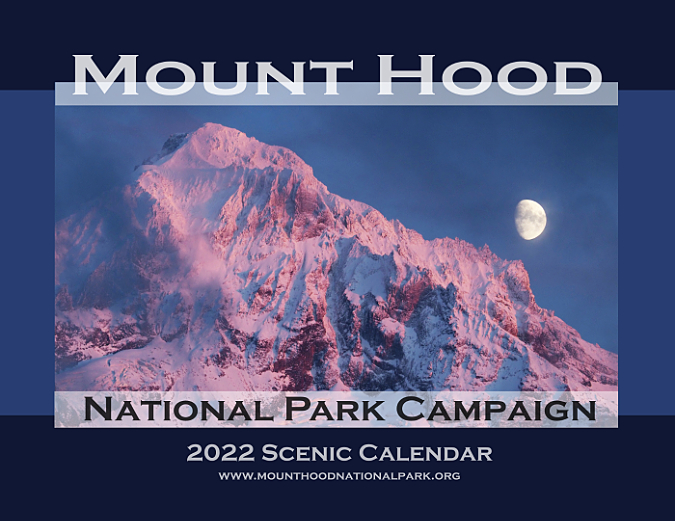
If you have followed this blog for a while, then you know I gather up my best WyEast images each year and publish them in the Mount Hood National Park Campaign Scenic Calendar. They are available online, and all proceeds from the calendars go the Trailkeepers of Oregon (TKO), a non-profit trail advocacy and stewardship organization that I’ve volunteered with since TKO formed, way back in 2007.
I’ll post more on how to order the 2022 calendar at the end of this article. But first, here’s a preview of the images, along with a few stories behind the photos.
The January image (below) and cover shot (top) in the new calendar were taken on the same magical evening at Lolo Pass, just a few weeks ago. The clouds framing the mountain were condensing right above me on this clear, cold evening, as they often do here, when moist Pacific air is compressed as it pushes over Lolo Pass on Mount Hood’s northwest shoulder. In winter, this geographic phenomenon can create a localized freezing-fog event at Lolo Pass, though it might be sunny and dry for miles in every direction!
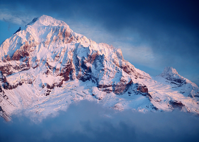
January features Mount Hood alpengow from Lolo Pass
I’ve spent many evenings at Lolo Pass photographing alpenglow on the mountain under these conditions, and the fun (or frustration!) comes with the mountain peeking through the clouds, then quickly disappearing, once again. Because the prime evening light lasts for only a few minutes, those moments when the clouds suddenly part to reveal alpenglow on the mountain are a real thrill for photographers. On this evening, I was joined by another photographer, and we both cheered when the clouds opening up to reveal not just the mountain, but also the moonrise appearing over his shoulder! The moment was over after just a few seconds, but it is captured in the cover photo for this year’s calendar. It was the also the last time WyEast revealed himself on that memorable evening.
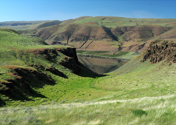
For February, I chose an image of Cedar Island, a botanical anomaly located in the heart of the Deschutes River canyon. This article from earlier this year tells the story of this odd group of Incense Cedar trees mysteriously growing far outside their normal range and habitat and somehow thriving in the middle of desert country, thanks to a confluence of unique conditions.
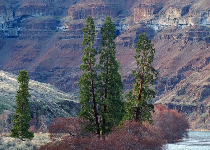
February features mysterious Cedar Island in the Deschutes River Canyon
These trees are truly oddities, but as described in the article, they’re also doing quite well. They have now established a satellite colony on the shoreline opposite the island, where a combination of shade and underground springs has allowed them to thrive. You can visit this grove by following the Deschutes River access road north from Sherars Falls for a few miles, just beyond Beavertail Campground.
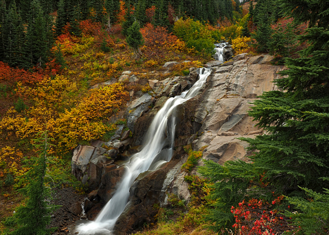
As the 2017 Eagle Creek Fire begins to fade into our collective memory, and the post-fire recovery of the Columbia River Gorge continues to unfold, there are plenty of surprises. Perhaps most startling are the twin cliff collapses at Metlako Falls and nearby Punch Bowl Falls, along Eagle Creek. The Metlako overlook collapse occurred about nine months before the fire, but the Punch Bowl Falls event followed the burn. Some speculate the latter event was triggered by changes in runoff and the water table resulting from the burned forest. It’s an intriguing theory, though we may never really know for sure. What is certain is that both events are part of the ongoing evolution of the Gorge landscape, though we tend to think of it as static.
A similar collapse on a much larger scale occurred at nearby Tanner Creek in 1973, temporarily damming the creek and forming a lake that persisted for several years. The March calendar image features Wahclella Falls (below), framed by house-sized boulders that mark the many cliff collapses that have occurred here over the millennia.
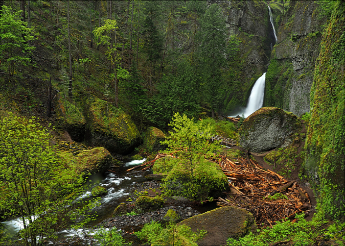
March features Wahclella Falls on Tanner Creek
The Eagle Creek Fire burned lightly in the lower section of the Tanner Creek canyon, sparing many of the big, old trees here. However, the story in the upper Tanner Creek canyon is starkly different, with much of the overstory completely killed. Though just four years have passed since the fire, hundreds of logs from trees burned upstream have already collected in the side channel just below Wahclella Falls (below), forming a huge log jam that spilled onto the trail! Volunteers from TKO had to saw a path through the debris to reopen the trail in the winter of 2020-21.
What will the post-fire future bring to Tanner Creek and Eagle Creek? A LOT more logs, that much is certain. Some logs will make it downstream to the lowest stretches of the Tanner Creek, where biologists once placed logs and boulders in an attempt to improve salmon habitat. Now, the Eagle Creek fire is about to provide a major assist in that work by delivering a lot more logs in coming years.

Panoramic view of the new log jam below Wahclella Falls
The logs in Tanner Creek (and other major streams in the Gorge affected by the fire) may be new to us, but they are really just a return to what used to be, before fire suppression, when the Gorge was much less forested and the streams were filled with a lot more logs. That’s good news for the health of the forest and the endangered salmon and steelhead that rely on log-filled streams to spawn, as well as wildlife that depend on a forest with a mosaic of old growth forests, recovering forests and open patches created by fire.
For April, I chose a somewhat deceptive image from a spot called Fairbanks Gap (below), in the eastern Columbia River Gorge. One deception comes from the fact that Interstate-84 is not only out of sight, but also out of hearing range from this spot, despite being directly below the cliffs that frame the gap. Another is that this scene is on private land, and thus a reminder that without the Columbia River Gorge National Scenic Area protections, a lot more places like this would have vacation homes (or worse) constructed on them. Instead, this remains a working cattle ranch – though I hope someday it will make its way into public ownership for permanent protection.
April features Fairbanks Gap and the east Columbia River Gorge
You can follow a nice backroad loop past the Fairbanks Gap by taking Fifteenmile Road out of The Dalles, and turning sharply uphill onto gravel (and signed) Old Moody Road at the rural crossroad community of Fairbanks (which features a lovely one-room schoolhouse). From here, Old Moody Road climbs to the gap, then traverses high bluffs above the Columbia River, with many spectacular views, before descending to Deschutes State Park, along I-84. My favorite time to visit this area is in late spring, when wildflowers line the old roads, and the eastern Gorge is verdant green.
The May image also features the eastern Gorge, this time at Rowena Plateau during the annual wildflower show. Yellow-flowered Arrowleaf balsamroot and blue-blossomed Lupine are the showy stars here, but the plateau is home to dozens of wildflower species, some found only in this part of the Gorge.
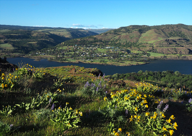
May features Rowena Plateau (and the town of Lyle, across the river)
In recent years, Rowena Plateau and the trail to McCall Point have been “discovered”, and the place is often crowded with adoring visitors. To address some of the impacts of all those feet on the trails, TKO has been working on some realignments and repairs to the McCall Point trail, with an eye toward improving the grades and drainage in a way that makes the trails more resilient to both weather and boots.
The Nature Conservancy owns much of Rowena Plateau, and continues to allow visitors to their preserve. This is a real gift for the public to enjoy, and while the vast majority come to enjoy (and revere) the scenery, big crowds inevitably mean a few thoughtless people. So, while I was frustrated to see tagging on a boulder along the lower part of the McCall Point trail on this trip, I also wasn’t surprised.

Tagging on a boulder on Rowena Plateau – a growing scourge in the Gorge
Tagging has become a problem throughout WyEast country, and especially in the Gorge. It’s especially frustrating at Rowena, where a private non-profit has shown the generosity of allowing us to visit their preserve. We probably can’t stop tagging, but you can support the Nature Conservancy of Oregon with a donation for the excellent work they are doing in the Gorge.
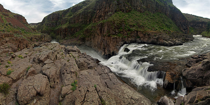
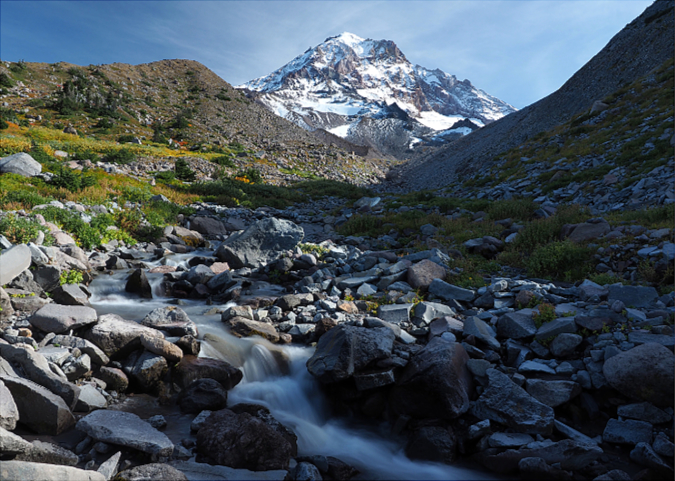
Our early and unusually warm spring this year came on the heels of an excellent snowpack, and that translated into heavy runoff and an impressive scene at White River Falls State Park, in the desert country east of Mount Hood. The June calendar image features a raging White River Falls (below), framed with bright green Cottonwood trees. The park encompasses the two-tiered main falls and a lesser-known lower falls, along with the fascinating ruins of a turn-of-the-20th Century hydroelectric project that once powered The Dalles.
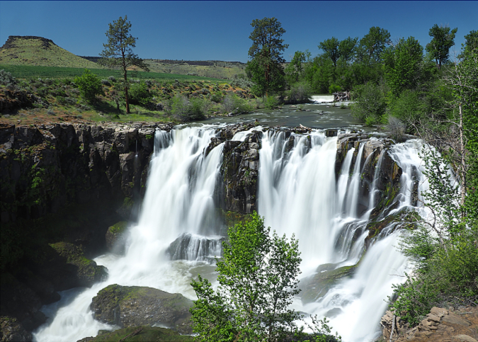
June features White River Falls during spring runoff season
Only photographers would notice this aesthetic improvement to the main falls overlook – but sometime over the past years, a pair of long-dead Cottonwoods that partly blocked the view finally collapsed… or were perhaps were removed by park officials? The latter explanation is quite plausible, as the Oregon Parks and Recreation Department has stepped up their efforts to maintain this somewhat remote park, including buttoning up the historic powerhouse, where vandals had covered some of the walls with tagging and damaged some of the old machinery.
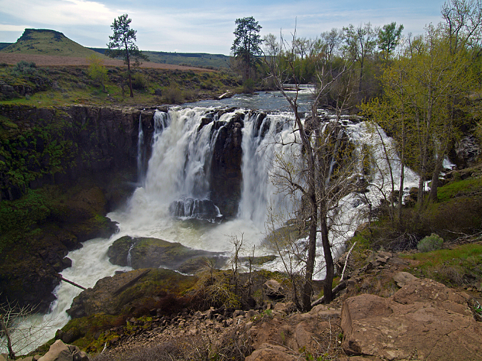
Snaggy former view of White River Falls… these dead trees are gone!
In the years I’ve spent visiting this little park, it has gone from very obscure to quite popular, and even the boot path to the once little-known lower falls is now well-worn. In a coming article, I’ll post some trail concepts for improving some of these boot paths and adding new trails to better manage some of the human impacts as visitation continues to grow.
Lower White River Falls and Gorge
For July, I chose an image from a favorite spot along the Cooper Spur Trail, overlooking the mighty Eliot Glacier, largest of Mount Hood’s glaciers. Our long spring and record-setting summer heat were hard on Mount Hood’s glaciers, and by late summer the Eliot Glacier was looking especially beleaguered. This image (below) was captured in late September, after an early snow had given the glacier a new coat of white, and the annual summer melting had finally slowed for the year.
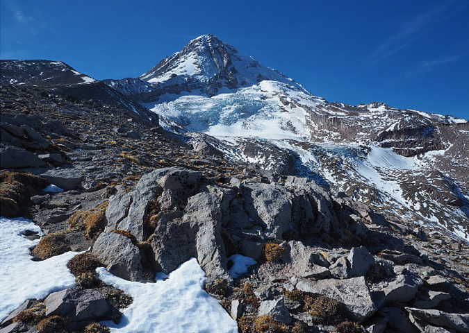
July features the still-magnificent Eliot Glacier
As I was shooting this image of the mountain and the Eliot Glacier, I spotted a mountain rescue team training at the base of the lower icefall. There was a time not too long ago when the seracs (or ice pinnacles) in the lower icefall with turquoise-blue and a prime ice climbing area.
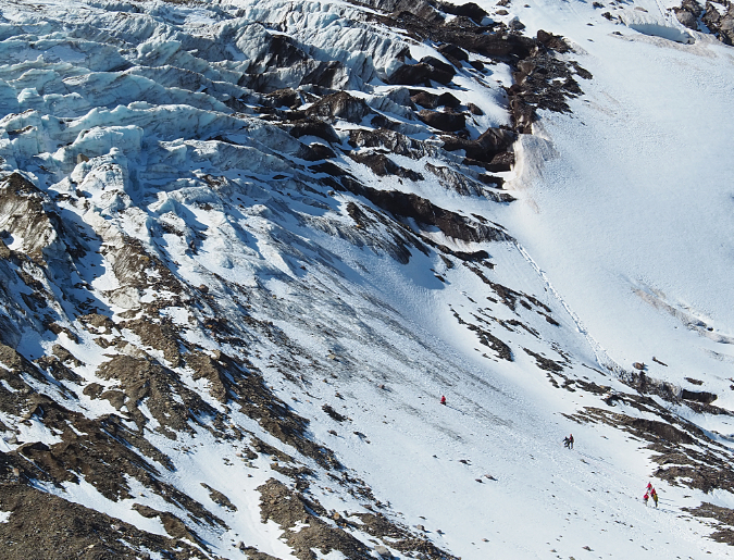
Climbers training in mountain rescue below the lower Eliot Glacier icefall
But the continued retreat of the Eliot Glacier has now moved the firn line above the lower icefall in recent years, and the seracs are now dark with glacial till and rock. The firn line is where a glacier is losing more ice than it is gaining, so as the glacier recedes the firn line gradually moves higher.
This is pair of images (below) that I’ve taken over the past decade from this spot, and I post them not to make readers feel sad or discouraged, but rather, to underscore the sense of urgency we all must feel in our collective response to global warming.
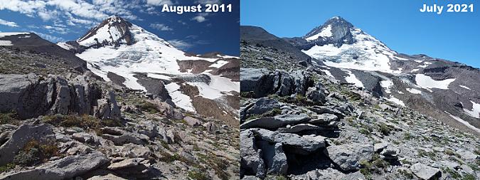
The Eliot Glacier has receded markedly over just the past decade
[click here for a much larger version of this comparison]
The accelerated Eliot Glacier retreat over the past two decades has had all sort of impacts, but near the top of the list of concerns is the impact on downstream fisheries that depend on cold, dependable runoff from the glacier. A more visible impact has been the deep erosion and periodic floods and debris flows that have reshaped the Eliot Branch canyon, below the glacier.
Though I know both the science and politics are challenging, I’m hopeful that we’ll find a path toward a worldwide shift away from carbon pollution in my lifetime. Future generations may not see the Eliot Glacier as I once knew it, but hopefully there will be a smaller Eliot Glacier they can stand in awe of, still tumbling down the slopes of Mount Hood.
At the opposite end of the glacial spectrum, the August calendar image features the icy stream that flows from Mount Hood’s tiniest living glacier, the tenacious Glisan Glacier, located high on the northwest shoulder of the mountain. For some reason, this glacial outflow was never given a proper name by early mountain explorers, despite many smaller streams on the mountain being named. The oversight is a bit of a mystery, as there were several well-documented trips to this side of the mountain in the early 1920s and 1930s by the Mazamas for the very purpose of mapping and naming the features here.
August features “Glisan Creek”, the glacial outflow from the tiny Glisan Glacier
As a default, many call this “Glisan Creek”. That’s not a bad option, since there’s a good chance the glacier, itself, will fall victim to global warming in coming decades, and only the creek will remain. The Glisan Glacier was named for prominent Portlander Rodney Glisan in 1938. Some of the history of all of Mount Hood’s smallest glaciers is included in this earlier article on Mount Hood’s Pint-Size Glaciers.
After an especially long and dry spring and summer in WyEast Country, fall brought early snow and some of the best fall colors in memory to the mountain. The scene below, at the McNeil Tarns, was captured after the first dusting of snow in late September, and it’s also the calendar image for that month in the new calendar.
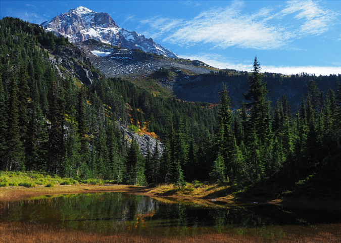
September features the McNeil Tarns on Mount Hood
This is a well-known spot along the Timberline Trail, as it is located along the approach to popular McNeil Point on the northwest shoulder of the mountain and visited by thousands of hikers each year. While most hikers know of the pair of McNeil tarns located immediately adjacent to the Timberline Trail, few know of the third, lesser-known tarn in this trio. It’s located just off the Mazama Trail (below). Thanks to a dense veil of trailside Huckleberries, Mountain Ash and young Mountain Hemlock, this beautiful tarn is known to surprisingly few, but it is no less lovely than its more popular siblings.
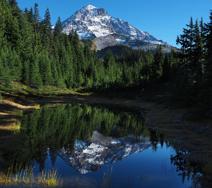
The Mazama Tarn near McNeil Point on Mount Hood
Over the past five years, I’ve posted several articles about Punchbowl Falls Nature Park, the newest public lands in WyEast Country. The new park is the product of determined volunteers at Thrive! Hood River and Trailkeepers of Oregon (TKO), and features a surprising abundance of forest types, river scenes and waterfalls. Dead Point Falls (the October calendar image, below) is among the park highlights, especially in fall when Bigleaf Maple, Vine Maple, Western Dogwood and Oregon White Oak light up the surrounding forest in shades of orange, yellow and red.
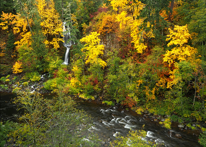
October features Dead Point Falls and the West Fork Hood River
Meanwhile, higher up on the mountain, beautiful Heather Canyon on Mount Hood’s southeast flank is especially lovely in fall, when Huckleberry and Mountain Ash turn the canyon into a brilliant watercolor of orange and yellow. Lower Heather Creek Falls (below) is the featured image for November in the new calendar.
November features Heather Creek on the southeast slopes of Mount Hood
There are a couple ways to hike into Heather Canyon, but I always opt for the Newton Creek Trail approach, mostly to avoid walking through the Mount Hood Meadows ski resort. In the coming year, I hope to post a long-planned article with a somewhat radical proposal for rethinking Mount Hood Meadows – something we should all be considering as climate change threatens to put ski resorts as we know them out of business in coming years.
Anyone visiting Lookout Mountain on Mount Hood’s east side has probably noticed this beautifully framed view from Lookout Mountain Road (below), and I chose it for the December image in the new calendar. If the conditions are right, early snow on the mountain appears just as the Western Larch trees are turning to yellow and gold, and such was the case this year!
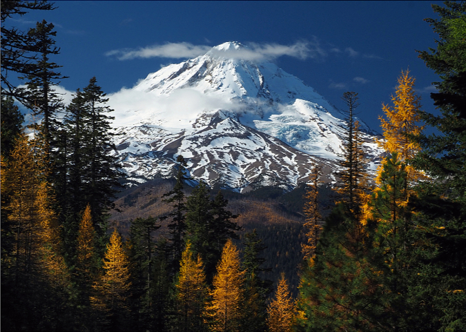
December features Mount Hood framed by Western Larch
I’ve photographed this spot too many times to count over the years and I’ve always thought of it as a scene only hikers knew about. However, a couple of days after capturing the calendar image, I was walking through my neighborhood grocery store and did a double take when I saw the scene on the cover of a nationally marketed calendar!
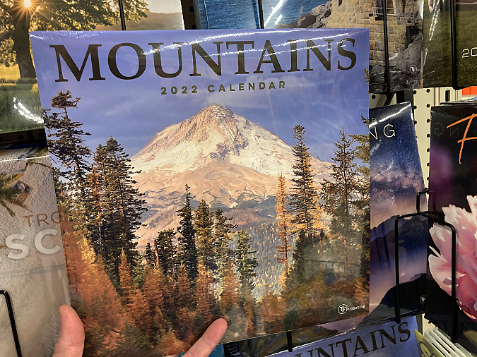
This looks vaguely familiar…
The photographer (and I’m not sure who it is) captured a less snowy version of Mount Hood, though it remains a beautiful image, and it’s great to see this lesser-known view of the mountain in wide publication.
Finally, the back cover of the new calendar features wildflower highlights from around WyEast country, ranging from the elegant Mount Hood Lily and Pacific Rhododendron to our state flower, the Oregon Grape (below).

The back cover of the calendar features a selection of wildflowers
There you have it! If you’d like to purchase a calendar, it’s easy to order direct from Zazzle:
2022 Mount Hood National Park Campaign Calendar
Each page in the calendar measures 11×14 inches (or 22×14” unfolded on the wall) and I’ve designed this as a functioning calendar, with date squares that you can actually write in! Zazzle prints these with exceptional quality and ships them carefully packaged with a backer board and moisture seal.
For another week or so, the calendars will sell for $29.75, but after December 20 that price will bump up to $34.95, with the additional five dollars of markup also going to directly to TKO, bringing the total to about $10 from each calendar to TKO for the great work they do. Zazzle typically ships these within a few days of ordering, and I usually receive orders within about 10 days.
Thanks for reading this far, and as always, thanks for visiting the blog – I hope to see you here and on the trail in the coming year!
Tom Kloster • December 2021

Such beauty captured!!!!
LikeLike