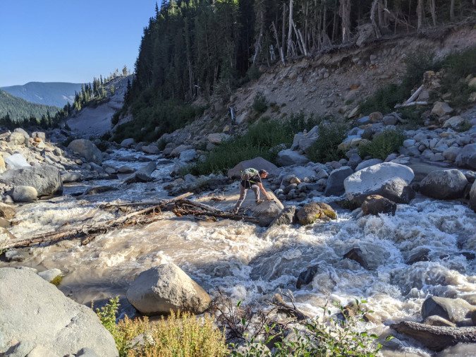
Hiker making a scary bridgeless crossing of raging Newton Creek along the Timberline Trail during summer runoff in 2022 (Craig Gwydir)
In this previous article, the story of Sarah Bishop included a call for restoring a footbridge over the Sandy River along the popular Ramona Falls loop trail. After her tragic death, Sarah’s family led a successful campaign to install signs at several wilderness entry points around the mountain warning hikers of the risks in crossing glacial streams and how to navigate them safely.
That was 20 years ago, and the situation has since grown urgent. The time has now come to simply provide bridges at the fourteen glacial stream crossings within the Mount Hood Wilderness. Why are the crossings so much worse? Here are the driving forces making the current situation unacceptable and now the moment to do something about it:
1. Sheer numbers of hikers: in one of their classic 1970s field guides, iconic authors Harvey Manning and Ira Spring once described the Mount Hood Wilderness as “mobbed year-round”. Both passed away in the early 2000s, and they probably couldn’t have imagined what “mobbed” really looks like, as what they saw as mobs the 1970s would be dwarfed by today’s crowds. The explosive growth in public demand for wilderness trails around Mount Hood translates not only to overflowing trailhead parking, but also traffic jams at the mountain’s most notorious glacial stream crossings, where hikers often wait in line to navigate sketchy logs or user-rigged “bridges” to cross.
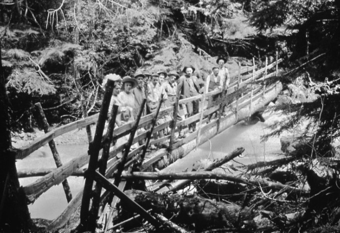
Crossing Mount Hood’s glacial streams has always been a challenge for hikers. Rails were added to a fallen log to create this bridge over the Zigzag River in the 1920s (Gary Randall)
Hikers are also less prepared for these obstacles today, thanks to social media driving the demand. Where hikers of the 1970s might have read one of the Spring & Manning or Don and Roberta Lowe guides to plan their trip, and thus become aware of these obstacles, today’s hikers are far more likely to have planned their trips based on a random Instagram image or Tik Tok videos that rarely bother to include meaningful trail information.
2. The glacial streams are a ‘changin: If you’re an old-timer, you probably remember when footbridges crossed several of the big streams on Mount Hood. That was a time when global warming was still a theory and glacial retreat was barely perceptible (though it was already underway), allowing for permanent structures at several crossings. Today, we can see the glaciers changing every year, and their retreat has wreaked havoc at downstream crossings.
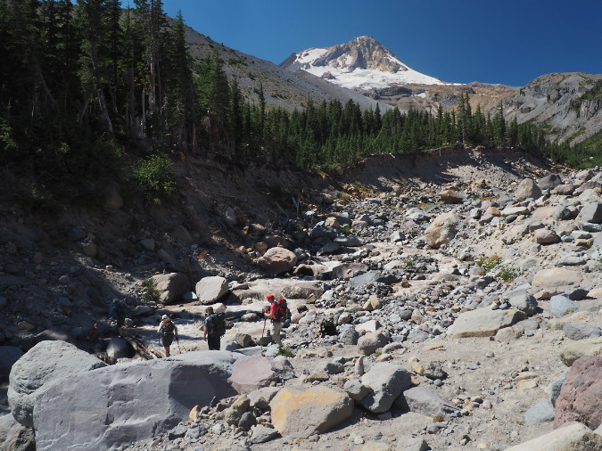
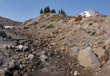
The Newton Creek crossing on the Timberline Trail is nearly 30 feet lower than it was just two decades ago, thanks to a series of floods and intense stream erosion resulting from climate change
As the ice melts away, U-shaped glacial valleys are rapidly eroding and deepening to become V-shaped river canyons. New channels are continually forming downstream from the glaciers as heavy loads of debris from upstream erosion are released into glacial streams. Winter debris flows and summer flash floods have also become a routine event on the mountain, presenting a volatile, continually changing landscape.
3. Hiker safety: Mount Hood is increasingly an urban wilderness dominated by day-hikers, less experienced hikers, families with young kids and some people with disabilities. This is to be expected — the mountain is just an hour away for some 2 million people – more than four times the population living in greater Portland in the 1930s, when the Timberline Trail was originally constructed.
Like it or not, these numbers will only continue to grow, in part because our unique quality of life – including a mountain in our collective backyard — continues to bring people to our region. So, given this reality, will our mountain be a wilderness for everyone, or just those who are physically able to wade a torrent of thigh-deep glacial runoff or inch across a wobbly log six feet above the water?
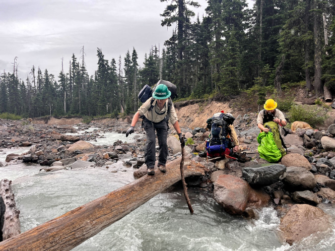
Volunteers from Trailkeepers of Oregon (TKO) making a sketchy crossing of Newton Creek enroute to a multi-day wilderness stewardship event within the Mount Hood Wilderness. Among their gear are 7-foot manual crosscut saws – the only saws allowed for clearing trails within the wilderness.
The hazards presented by the glacial crossing affect more than just hikers. Trail crews, backcountry rangers and emergency responders carrying heavy gear are also forced to navigate these obstacles – sometimes to rescue folks injured while making the same dangerous crossings.
4. Quality of the (urban) wilderness experience: People go to the Mount Hood Wilderness for the exceptional alpine scenery and a reasonably rugged experience. For most, this simply means an unpaved mountain trail, not confronting scary obstacles that leave them shaken and reluctant to return.
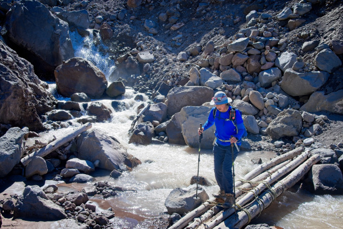
Timberline Trail hiker crossing a user-rigged log crossing on the notorious Eliot Branch in 2023, the volatile outflow from Mount Hood’s largest glacier (Guy Meacham)
There are wilderness purists who argue that it should be this way, and those unable to handle the risks should simply stay away. It’s an elitist argument that – unfortunately – is also made by some of our land managers as an excuse to do nothing. Fact is, Mount Hood is an urban wilderness (see No. 1, above), not the Alaskan frontier. For elite hikers seeking physical danger and hardship in their outdoor experience, there are dozens of wilderness areas beyond the day-trip range of major urban areas like Portland to choose from. Mount Hood just isn’t one of those places, and it never really was.
5. It’s good for business: Just as many people from our area think Mount Hood is already a national park (really!), so do visitors from around the country — and the world. The Timberline Trail brings untold numbers of long-distance travelers to the area every year, most thinking they will enjoy a national park-like quality experience on their 40-mile circuit. Over the years, I’ve encountered many of these folks on the trail and have been saddened to hear of their disappointment – not with the spectacular scenery, which they marvel at – but of the deteriorating trail conditions and especially the stream crossings.
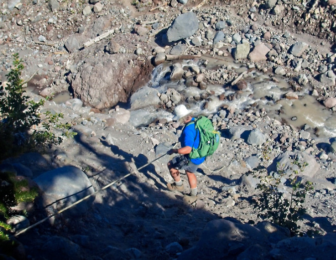
Hikers from around the world come to Mount Hood to experience the Timberline Trail, only to find themselves descending on random ropes left by previous hikers to navigate scary, bridgeless stream crossings (Chiyoko Meacham)
Why does this matter? Because visitors from out of state or other countries are the folks most supporting the tourism economy in the communities surrounding the mountain, from lodging and restaurants to local guide services, museums, galleries and farm stands. Yet, the quality of the Timberline Trail experience is rarely appreciated for its benefit to the local economy. Visitors from elsewhere are essential to any local tourism strategy, but with the current state of the trail, we are doing our very best to discourage positive experiences and repeat visits from beyond Oregon and Southwest Washington.
6. Real funding options: Did you know the Forest Service issues special use permits to private, for-profit businesses to maintain many of our campgrounds and trailheads, and even to conduct private trail events on Mount Hood each year? More significantly, this includes the large ski resorts who operate on our public lands under special permit, and who are increasingly marketing themselves as hiking destinations. Should these commercial interests be part of funding needed trail improvements on the Timberline Trail – including stream crossings? Absolutely. More about that toward the end of this article.
7. No more legal excuses: On December 27, 2021, the U.S. Court of Appeals ruled in the Ludwig vs. the United States case that the U.S. Forest Service was immune from wrongful death liability after a hiker drowned while attempting to cross a footbridge over the Sandy River near Ramona Falls during an extreme storm event.
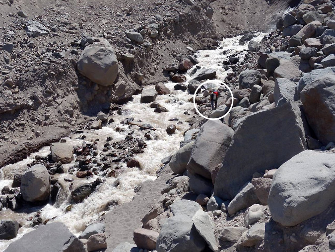
Can you see the hikers (circled) contemplating a ford of the Eliot Branch – and perhaps giant boulders teetering above the stream? Nobody should face this degree of physical risk when hiking the Timberline Trail (Robin Barklis/Portland Hikers)
The Ludwig case has long been pointed to as the reason for not providing safe crossings there, or anywhere within the Mount Hood Wilderness, but the case has since been decided. Now, it’s simply an excuse for doing nothing – though, ironically, it’s conceivable that not doing anything could open the agency to some future liability claim for exactly that reason.
It’s time to move beyond legal liability excuses and simply make public safety the priority, once again. It’s time to finally make the Timberline Trail a safe, world-class experience for everyone.
Fifteen Crossings?
So, where are the footbridges needed? At all fifteen glacial stream crossings within the Mount Hood Wilderness. All of them – though more on how to tackle that in a bit. Here they are in the traditional clockwise order that hikers experience, beginning at Timberline Lodge, each scored according to their relative fear-inducing capacity:
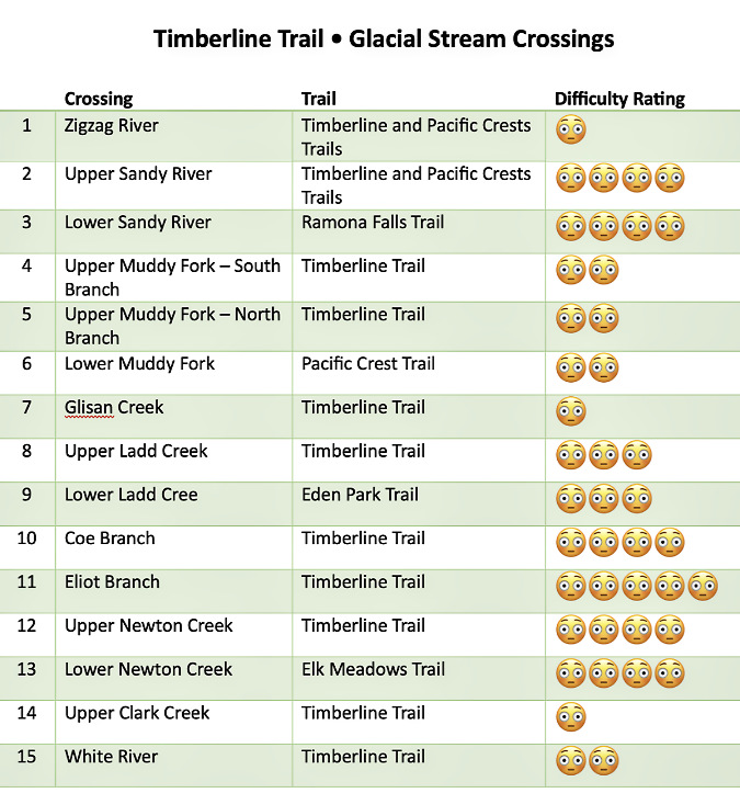
[click here for a large version of the table in a new window]
Here’s a map of the proposed glacial stream footbridges. Most are located along the Timberline Trail (and the Pacific Crest Trail where the two overlap), along with two popular alternate routes to the Timberline Trail at Eden Park and Elk Meadows and the major access point to the loop at Ramona Falls:

[click here for a large version of the map in a new window]
What do the worried emoji ratings mean? They are subjective based on my own hiking experiences over the years, along with those of many others in my hiking circles. They range from a ranking of one emoji (rock hop, usually with dry feet) to four or five emojis for scary crossings in fast, icy, thigh-deep water that even the most experienced hikers struggle to cross during the summer peak glacial melt.
It’s no surprise that the Eliot Branch should rise to the top of the list, as it is fed by Mount Hood’s largest glacier and has experienced some of the most dramatic erosion and canyon deepening on the mountain in recent years. In contrast, the Zigzag River, Glisan Creek and Upper Clark Creek crossings are not major obstacles for most hikers. However, any of these have the potential to be dangerous during summer glacial outbursts and thunderstorms, as was the case for Sarah Bishop.
Going by the book..?
What is the official line from the Forest Service on providing stream crossing structures? It’s fairly specific. Here’s what the Forest Service trail handbook has to say:
______________
“Stream and river crossings present a challenge to trail managers who need to balance difficulty levels, safety, convenience, cost, environmental consequences, and esthetics. At one end of the use spectrum, a bridge can allow people with disabilities, toddlers, and users who are new to the outdoors to experience the trail with little risk.
“But bridges are expensive. Wilderness visitors who expect a challenge may prefer a shallow stream ford. During high water, these folks may opt for a tightrope walk across a fallen log. Each kind of water crossing has consequences for the recreation experience and the lands being accessed. Choose wisely from the spectrum of options before committing present and future resources to any given crossing.”
______________
The key in this guidance is the focus on the spectrum of user abilities. “Wilderness visitors” are implied to be at the most experienced end of the spectrum, and assumes these hikers are both aware of the meaning of designated wilderness and are either seeking — or at least expecting – to ford streams on their own.

The sturdy Clark Creek Bridge is a bit of a relic from days when the Forest Service actively provided bridges around Mount Hood. It’s a permanent bridge that has survived for years, thanks to Clark Creek being the less rambunctious outflow from the Newton Clark Glacier to its rowdy twin Newton Creek. Today, it is the only bridged glacial stream crossing on the mountain. Clark Creek forms the Mount Hood Wilderness boundary, here – the wilderness entry sign is on the opposite end of this bridge.
This is almost never the case on Mount Hood. How to know that? Just look at the footwear (sneakers and flip-flops) and lack of trail safety basics on many of the folks heading into the wilderness, often without even a pack or bottle of water, much less a map or knowledge of the trail. All too often, ill-equipped hikers also have young kids and pets in tow.
The key wording from the Forest Service guidance on this less experienced end of the user spectrum should apply to all of Mount Hood’s glacial stream crossings: “a bridge can allow people with disabilities, toddlers, and users who are new to the outdoors to experience the trail with little risk” (author’s underscored emphasis added).
What is the Minimum Tool Philosophy?
There’s more guidance from the Forest Service best practices on footbridges that comes from the “minimum tool philosophy”, which seeks to “get the job done with the least long-term impact while still meeting management objectives”. That’s a mouthful, but here are the considerations included in this part of the agency technical guidance:
- Do we really need a bridge here? Do we really need to cross here early in the spring?
- Will someone be killed or injured if we don’t provide an easier crossing?
- Is this really the best place to cross this stream?
- What alternatives do we have to cross this stream, including not crossing it at all? Can we afford this crossing?
- What are the environmental and social consequences of a given type of crossing here? Can we commit to long-term inspections and maintenance?
- Who will really care if we don’t build (or replace) a bridge?
A telling footnote in this section of the Forest Service guidance adds that “it’s a wonderful thing to keep one’s feet dry, but keeping those feet dry in the backcountry is expensive.” For me, this comes across as surprisingly dismissive and elitist, but the list of “minimum tool” considerations are nonetheless easy enough to address in the example of the Timberline Trail.
The first two questions answer themselves – we already know many of the crossings on Mount Hood are dangerous, but also that travel is highly seasonal. The third, fourth and fifth questions also answer themselves: the Timberline Trail is an iconic feature that can’t simply be closed for lack of a desire or funding by the agency to make it safe to travel. It’s the Timberline Trail, after all! People come from around the world to experience this historic trail. Enough said.
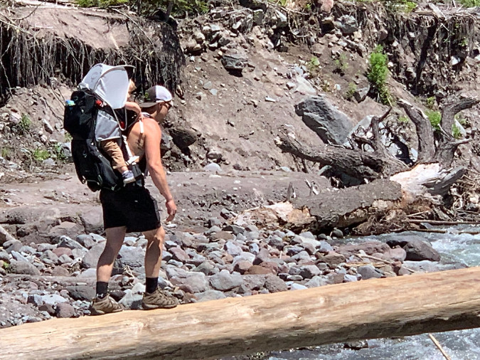
Yikes! Hiker forced to carry a toddler over a very high log crossing over the Lower Sandy River in 2022 (TKO)
The final question seems obvious, but it does go to the larger problem that the Timberline Trail isn’t actively championed by anyone beyond the hiking community. But would anyone other than hikers “really care” if the bridge problem remains unresolved? No doubt, though the economic value of trails is almost never featured in local tourism programs, and thus not really understood by the broader community.
The two counties that encompass most of Mount Hood – Clackamas and Hood River – market themselves heavily at tourism destinations, yet have minimal content on their tourism websites for Timberline Trail visitors beyond a link to the Forest Service web page for the trail, which currently opens with this grim warning:
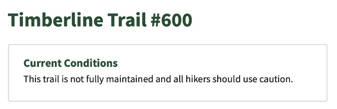
Makes you proud to be an Oregonian, right?
Be they local day hikers or international travelers coming to experience the Timberline Trail, all visitors to the mountain should obviously be part of the local tourism strategy. That’s a bigger nut to crack, but a good start would be making the trail safe so that disclaimers like this aren’t the first thing a prospective visitor sees when planning a trip to our mountain.
What are some working examples?
When it comes to suffering the effects of rapid climate change on its streams, Mount Hood has plenty of company from glacial peaks around the world. The best peers to learn from are right here in the Pacific Northwest, where trails on the other big Cascade volcanoes are also being impacted by the same forces we’re seeing on Mount Hood. There are also great regional examples of bridge structures provided within designated wilderness — including within the Mount Hood National Forest!
As around-the-mountain trails go, Mount Rainier’s Wonderland Trail is the Timberline Trail writ large. The trail covers 93 miles compared to Mount Hood’s 40-mile loop, and Mount Rainier has 28 glaciers compared to Mount Hood’s 12, several of them dwarfing the size of Mount Hood’s largest glaciers – and similarly outsized glacial streams, as well.
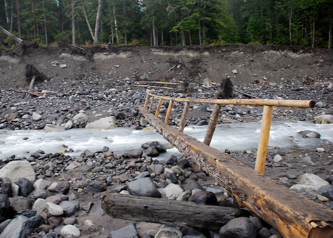
Carbon River Bridge, Mount Rainier National Park. This simple design is the most common in the park. It can be repositioned when needed, and easily replaced if lost to a major flood event (NPS)
Mount Rainer is protected as a national park, of course, and the Park Service strictly manages the Wonderland Trail as a pristine wilderness experience. Though it’s an ongoing struggle, park rangers work to provide seasonal crossings on the major glacial streams throughout the hiking season, though they do wash out frequently, leaving hikers to navigate on their own until the bridges can be re-installed.
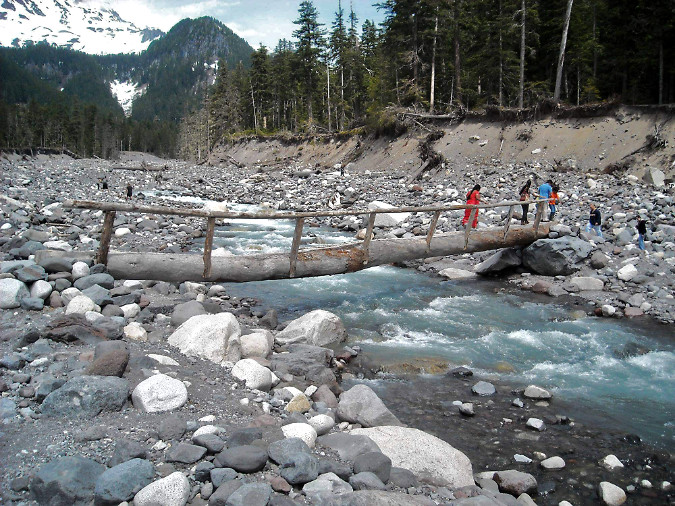
Nisqually River Bridge, Mount Rainier National Park (NPS)
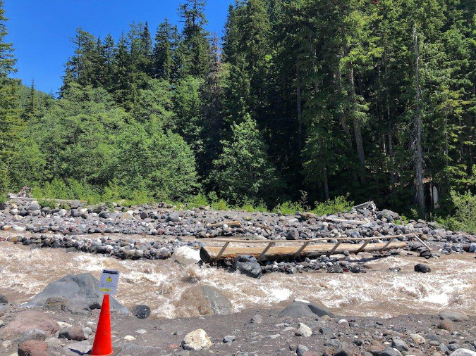
Nisqually River Bridge temporarily out of service due to shifting river channels. The sign on the cone in the foreground cautions hikers on the best way to navigate the crossing in the meantime (NPS)
The Park Service at Mount Rainier has coped with this challenge with much less formal crossings, often simply a long, locally-sourced log with a single handrail that can be sacrificed should (or rather, when) the next flood sweeps down from the glaciers above. Hikers are cautioned to prepare for occasional washouts and difficult crossings each year, though the management goal is to make this classic trail as safe and enjoyable as possible. The park web page for the trail also includes extensive detail on current conditions, backcountry regulations and tips for planning a trip that would be a great template for expanding web content for the Timberline Trail.
Heading north to Mount Baker, the Forest Service has provided a decidedly industrial, aluminum seasonal bridge in the past at Rocky Creek (below), a glacial outflow within the Mount Baker National Recreation Area. Though the design would not be appropriate for a wilderness setting, the seasonal placement is a helpful guide, as this stream is much like Mount Hood’s larger glacial outflows.
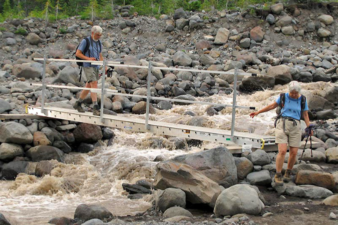
Rocky Creek Bridge, Mount Baker National Recreation Area (Adam Schneider)
At Olympic National Park the newly built, permanent crossing of the Soleduck River (below) is a handsome solution that could work at downstream locations like the lower Muddy Fork on Mount Hood, where the river channel is less volatile and a large bridge could connect relatively stable, forested banks like these. While the Olympic peaks along the High Divide that feed into the Soleduck no longer have active glaciers, they do have an impressive snowpack each winter and famously heavy precipitation that required this bridge to be built for regular stream flooding.
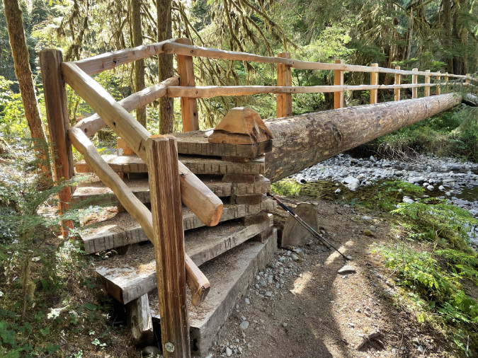
The beautifully constructed Soleduck River Bridge in Olympic National Park (Tom Lovett)
Turning south and back to Oregon, the Fall Creek Bridge (below) in the Three Sisters Wilderness is another fairly new example of a permanent bridge on a heavily traveled wilderness trail. Though it does span a glacial outflow from the South Sister’s Lewis Glacier, the volatility of the meltwater is greatly reduced by the Green Lakes, which act as a jumbo settling pond for the silty glacial runoff. This is why Fall Creek is both crystal clear and fairly stable within its banks downstream from the lakes, and why a permanent bridge design could be constructed here. Like the Soleduck River example, this structure could be a model for the lower Muddy Fork, where a permanent bridge seems feasible.

Fall Creek bridge near one of the main gateways into the Three Sisters Wilderness
Contrary to what you may have heard, the Mount Hood National Forest has recently built (or rebuilt) several footbridges within its designated wilderness areas. One example described in [the previous article on the subject] is the lower Ramona Creek footbridge, built within the wilderness just a few years ago, and just a short distance from the Lower Sandy River crossing. The justification here (and for the upper Ramona Creek bridge at the base of the falls) is simply the number of hikers on this very popular trail – a decision completely consistent with the Forest Service best practices.
A lesser-known example is this footbridge built over Gumjuwac Creek (below), in the heart of the Badger Creek Wilderness, just east of Mount Hood. Where Ramona Creek is relatively small, Gumjuwac Creek can be a seasonal challenge during spring runoff, and thus the decision to build this new structure a few years ago. Much of the Badger Creek Wilderness has burned in recent days as part of the ongoing Grasshopper Fire, so we don’t know the fate of this bridge at this time.
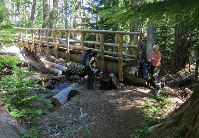
Gumjuwac Creek Bridge in the Badger Creek Wilderness (TKO)
Meanwhile, in the Mark O. Hatfield Wilderness in the Columbia River Gorge National Scenic Area, volunteers recently rebuilt this bridge along the Wahclella Falls trail, along with other structures affected by the 2017 Eagle Creek Fire. Like the examples from Ramona Falls and Falls Creek in the Three Sisters Wilderness, the decision to build permanent structures here is in recognition of the heavy trail use, again, consistent with Forest Service guidelines.
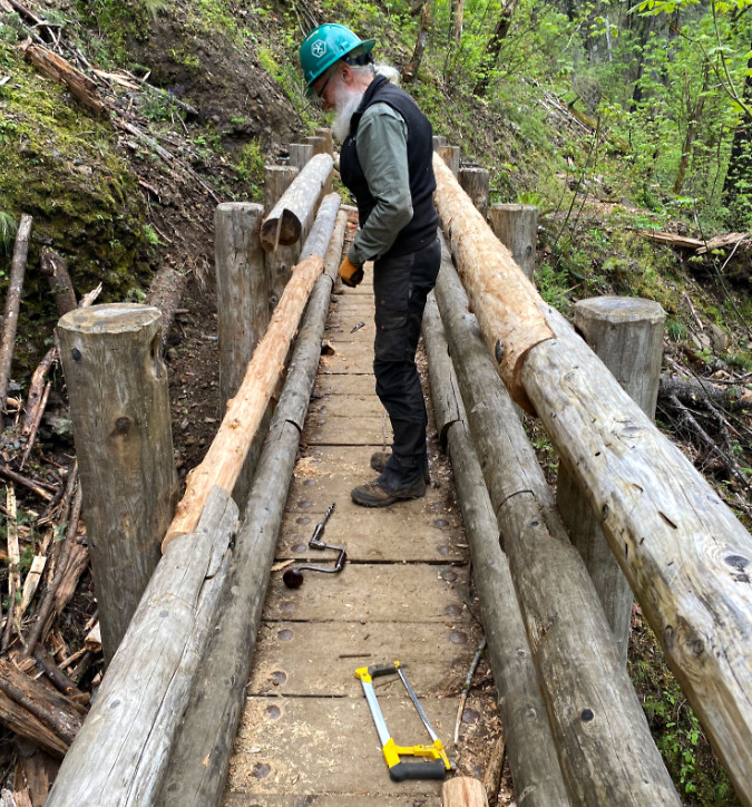
Trailkeepers of Oregon (TKO) volunteer repairing a winter-damaged bridge within the Mark O. Hatfield Wilderness (TKO)
These permanent bridge examples are included to debunk the idea that bridges along the Timberline Trail are somehow precluded by the Mount Hood Wilderness designation. It’s simply not the case, though it is true that permanent bridges on several of Mount Hood’s glacial streams would soon be washed away. So, what would a simple, straightforward and affordable solution for these crossings look like?
Read on…
A simple proposal for Mount Hood… hiding in plain sight?
It was plain sight — but a while ago. In their response to the 2008 Bluegrass Fire on the east edge of the Mount Hood Wilderness, fire crews were dispatched from the Elk Meadows trailhead. Crossing Clark Creek was simple, as the permanent bridge shown above was there and ready to serve the hundreds of firefighters who eventually descended on the blaze.
Crossing Newton Creek was another matter. There was no bridge and the stream is well known for its year-round volatility. In the urgency of the moment, necessity made for the simplest, most elegant and affordable solution possible. Using logs washed left along the floodway by the stream, firefighters simply cut them into manageable sections, then halved them down the center to make simple bridge spans. Smaller logs were cut and shaped with hand tools to form simple abutments. The designs were straight out of 1930s era Civilian Conservation Corps handbooks for backcountry engineering.
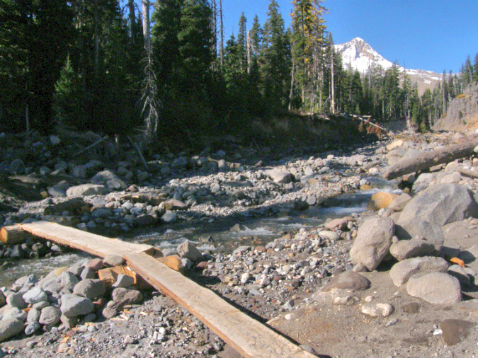
Seasonal crossing at lower Newton Creek built by firefighters to provide access to the 2008 Bluegrass Fire
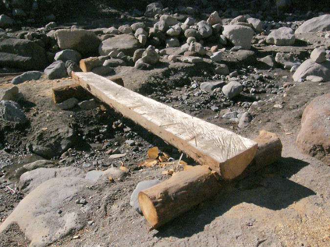
The simple design at Newton Creek allowed the crossings to be moved or adjusted with the ever-changing channels of Newton Creek as the fire operation progressed over several weeks
These designs were also the most compatible with their wilderness setting. There were no nails, no rock baskets and no concrete footings, just wood. They were also highly adaptive, with crews able to quickly move sections around to keep up with the ever-changing channels formed by Newton Creek during the summer runoff season. They could also be easily set back in place if the high water in the stream dislodged them. These simple crossings lasted through the fire, the following winter and into the next summer season, serving hikers long after the Bluegrass Fire had burned out.
Within a couple years, the logs crossing Newton Creek were eventually swept away and added to the many logjams downstream on this very rowdy glacial stream. Therein lies the beauty of this solution: it doesn’t matter. The logs were untreated and used no hardware in their installation, making them nearly indistinguishable from other logs piled along the stream. Yet, they still provided safe crossings for hikers who otherwise would have been wading the stream, or scrambling over loose logs, unsafe logs.
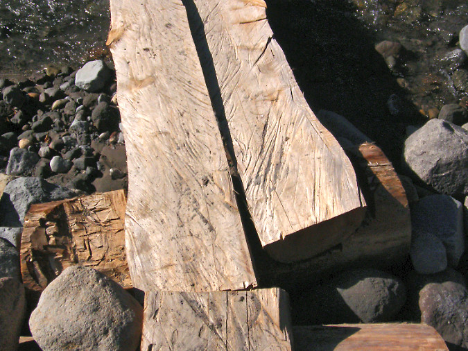
Detailed view of logs halved with chainsaws and cupped footings created with chainsaws and hatchets
These simple structures could be used on any of the fifteen glacial stream crossings in the Mount Hood Wilderness, including every one of the crossings on the Timberline Trail. The design is simple, adaptive, cheap and renewable.
The main constraint in the design for a wilderness setting is halving the logs, as this work was done with chainsaws during the Bluegrass Fire operation. Could logs simply be halved with crosscut saws? It’s possible, but time-consuming and impractical. Besides, volunteer organizations like Trailkeepers of Oregon (TKO) and others are already very busy just clearing fallen logs from our trails inside the wilderness that cross recent burns.
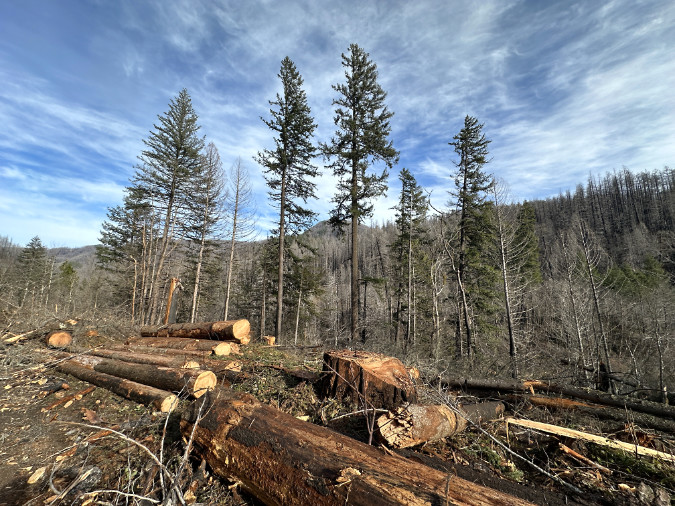
Logs stacked near Indian Henry Campground on the Clackamas River after the 2020 Riverside Fire
So, why were power saws allowed inside the Mount Hood Wilderness area in 2008? Because wilderness limitations on machinery are typically lifted during firefighting efforts, and it turns out these exceptions fall under the same provisions that allow the Forest Service to construct wilderness footbridges where needed to “protect the health and safety of persons within the area”.
Does that mean an exception could be made now for the purpose of constructing wilderness trail bridges? Unlikely. Short of a forest fire, lifting limits on the use of chainsaws in wilderness for any purpose remains controversial, even when a good case could be made for protecting the health and safety of the public. Therefore, this proposal calls for mass production of the half-log spans off-site, then transporting and caching stockpiles of 3-4 logs at each of the crossings, ready to install as needed.
How would this work for all of the glacial stream crossings in the Mount Hood Wilderness (except for the lower Muddy Fork crossing on the Pacific Crest Trail – more on that in a moment):
1) Prepare standardized materials offsite: Halved logs would be prepared offsite in stockpiled in standard 8-foot and 12-foot lengths. The Forest Service has a bounty of fire-killed logs at the moment in the Clackamas District, thanks to the 2020 Riverside Fire and subsequent blowdown events. These could provide decades of material for this purpose, and it’s work that could be done by contractors or volunteers as part of chainsaw certification programs that already take place there.

Logs stacked along the Clackamas River Highway after the December 2025 storms
2) Drop log caches: Caches of logs would be placed near 14 seasonal crossings – enough for three replacements and close enough to the crossing site to be moved into place by Forest Service or volunteer crews. The main lift (pun not intended!) in this step would be moving the log caches to the various sites, as it would require the Forest Service to make an exception to the Wilderness Act to bring helicopters in. This sounds harder than it is. Going back to the Wilderness Act, there are two important exceptions for using motorized equipment in wilderness for administrative purposes:
1) In emergencies involving the health and safety of persons within the area.
This is the provision that allowed for construction of the Newton Creek bridges during the Bluegrass Fire.
2) When a motorized or mechanized action is necessary as the minimum requirement for proper protection and administration of the area as wilderness.
This second exception clearly seems to apply, since trails themselves are core the Wilderness Act which states that “…wilderness areas shall be devoted to the public purposes of recreational, scenic, scientific, educational, conservation, and historical use”, and thus the administrative purpose. Helicopters would likely be less controversial than chainsaws, as the work could be done in as little as a single day and would not involve power equipment on the ground.

Helicopters used for logging can carry multiple, full-length logs per load (US Forest Service)
How would this work? Having photographed helicopter logging (from a safe distance) in the past, I’ve watched hundreds of logs moved in bundles of 2-6 raw logs measuring 30-50 feet in length over the course of a couple days. Dropping the caches of half-logs would only have to be done every few years, thus further minimizing impact on the wilderness. If the drops were timed for late fall, there would be minimal conflict with hikers, while still allowing ground crews to access the different stockpiling sites.
But does the Forest Service even own helicopters? Only a few, though the agency contracts or charters with dozens of private providers to carry out a host of forest management activities, so this work is easily within their wheelhouse of know-how and funding arrangements.
3) Seasonal bridge placement: while there’s no harm to the environment if a half-log bridge is swept downstream, the idea is to minimize that risk and reduce the need to replenish the cache at a particular site by placing them as seasonal crossings. A reasonable window could be from July 1 through October 31, the mostly snow-free season when the vast majority of hikers are entering the wilderness. Hikers attempting to cross the streams before or after that time would at least be aware of the lack of structured crossings.
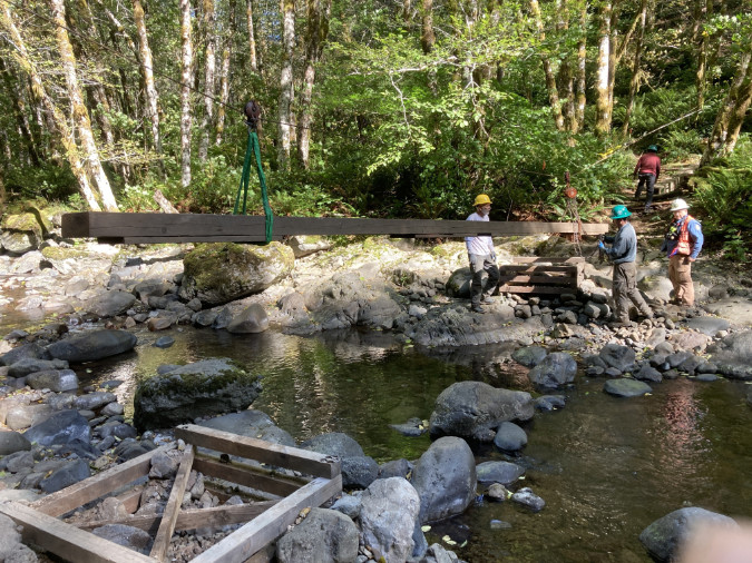
Trailkeepers of Oregon (TKO) volunteers work with the Oregon Department of Forestry to annually install and remove this seasonal bridge at Elk Creek on the popular Kings Mountain Trail
While the placement could be done by Forest Service crews, there are also at least two trail stewardship non-profits – Trailkeepers of Oregon (TKO) and the Pacific Crest Trail Association (PCTA) — that have the volunteer capacity, expertise and working relationship with the Forest Service to be part of placing these structures.
The Forest Service would need to periodically replenish the log caches at each site as logs are lost or damaged, though the idea of a cache is to minimize this need by providing enough material onsite to last for years. The abutment sections would be completely constructed onsite using manual tools, so only the half-log spans would be cached. The simplicity of the design would also allow backcountry Forest Service or volunteer crews to quickly reinstall or replace crossings that are impacted by flooding or channel changes during the summer hiking season.
Where to start?
Yes, this is a big proposal, given the status quo of doing nothing. Where to start? Following the informal “fear emoji” rating in the prior table, the three most problematic among the 15 glacial stream crossings are the upper and lower Sandy River crossings and the Eliot Branch.
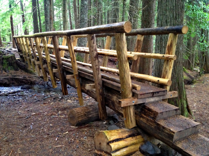
The Forest Service built this wilderness bridge on the Ramona Falls Trail – but how were materials delivered to the site?
All three of these sites could provide excellent pilot projects, not just because safe crossings are badly needed here, but also because they are close to trailheads. This could allow materials to be transported to the site without machinery, thus avoiding the complexity of helicopter drops in a pilot phase (pun also unintended!). They would also be easily accessible for volunteers to monitor and maintain. If these pilot projects are successful, then the program could gradually be expanding to the rest of the wilderness.
So, how did the Forest Service bring materials to the new Ramona Falls trail bridge that was constructed in 2012? Unclear, as the structure includes both logs that might have been sourced locally, but also dimensional lumber that must have been carried in. This somewhat recent project could provide guidance for a new seasonal bridge pilot project on the nearby Sandy River crossings.
There’s a notable exception in the list of 15 crossings, and it was mentioned in the permanent bridge examples from Olympic National Park and the Three Sisters Wilderness: the lower Muddy Fork crossing. For years, a very large log (shown above) has been in place at the crossing, serving as a “permanent” bridge of sorts for hikers. There spot is also a ford for horses, as this is a Pacific Crest Trail crossing.
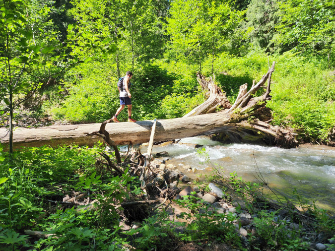
This log has survived several winters at the lower Muddy Fork Crossing, thanks to more stable banks and less channel shifting in this part of the Sandy River valley. A permanent bridge is a good option for this spot (Lily Peterson/Portland Hikers).
The lower Muddy Fork site is more like the lower Clark Creek crossing in that the stream is less volatile and the stream channel likely stable enough to support a year-round crossing structure. The site also lies in close proximity to the Ramona Falls trailhead, providing the same good access that allowed for the new wilderness bridges on Ramona Creek in recent years. This permanent crossing should also move forward now in tandem with the pilot project for seasonal crossings.
_______________
Fifteen new crossings are a lot to ask of an agency whose posture at Mount Hood has been to provide no safe crossings at all, so it would take some trail champions both within and outside the agency to take a first step. That could take the form of just a single pilot project right now, perhaps beginning on the upper Sandy River crossing that took Sarah Bishop’s life – or the lower Sandy River crossing that Sarah’s family has been advocating for?
There are non-profit trail partners ready to help. The Forest Service already has agreements with volunteer trail organizations to maintain trails within the Mount Hood Wilderness, notably Trailkeepers of Oregon (TKO) and the Pacific Crest Trail Association (PCTA). Other organizations like the Mazamas have provided trail maintenance on select trails within the wilderness over the years, as well. Compared to the ongoing need to trim brush and clear logs, placing seasonal bridges could also be a coup for drawing new volunteers to this needed work.
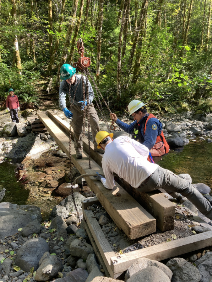
Trailkeepers of Oregon (TKO) volunteers removing the seasonal Elk Creek Bridge in the Tillamook State Forest at the close of the summer hiking season (TKO)
But there’s an outside-the-box option that the Forest Service has not considered in the past – and should. The agency grants special permits to several commercial operations to do business on our public lands, some to carry out work for the agency, like running campgrounds and maintaining trailheads. These contractors could be part of the solution, since they are already actively doing basic work for the agency.
But there’s a better opportunity worth exploring in providing these crossings: the major ski resorts on Mount Hood’s south side. In an era of climate change, the combination of shrinking, unpredictable winter snowpacks and soaring gear and ticket prices have resulted in an aging demographic of alpine ski enthusiasts in recent years. This is happening across the industry. Resorts have responded with summer activities designed to bring riders to their ski lifts in the summer months, notably mountain bike and hiking trails.
On Mount Hood, the Timberline and Ski Bowl resorts have leaned hard into mountain biking to keep their lifts busy in summer, but Mount Hood Meadows has opted for a bold focus on hiking, including construction of a dense network of trails that radiate from the day lodge and ski lift terminals. Ski Bowl advertises lift-based hiking as well, though most of the “trails” simply follow ski lift service roads, where the Meadows network offers real hiking trails built for people, not maintenance trucks. That’s a good thing!
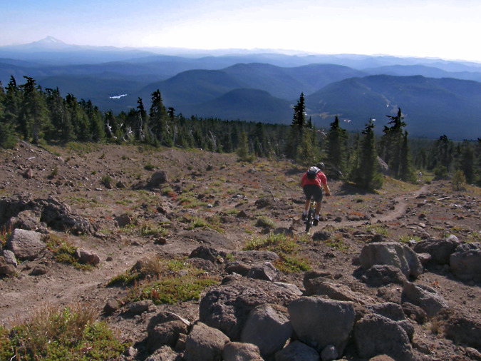
Mountain biker straying from Timberline resort private bike trails onto the public, hiker-only Mountaineer Trail, one of many public trails the resort includes in its advertised summer hiking trail network
For its part, Timberline maintains a tiny nature trail network adjacent to the historic (and publicly owned) Timberline Lodge, but the rest of the trails in its promoted network are all built and maintained by the public – including the Pacific Crest and Timberline Trail segments that pass through their permit area (though there are tremendous opportunities for the resort to help expand the system). Meadows also includes public trails in its hybrid network, including a section of the Timberline Trail, and all of its trails are open to the public.
Therefore, why not ask the two larger resorts to participate in maintaining wilderness bridges? The Timberline resort includes both the Zigzag and White River crossings in their advertised trail system. The Meadows resort includes the upper Clark Creek crossing on the Timberline Trail and both the upper and lower Newton Creek crossings are just outside their advertised network.
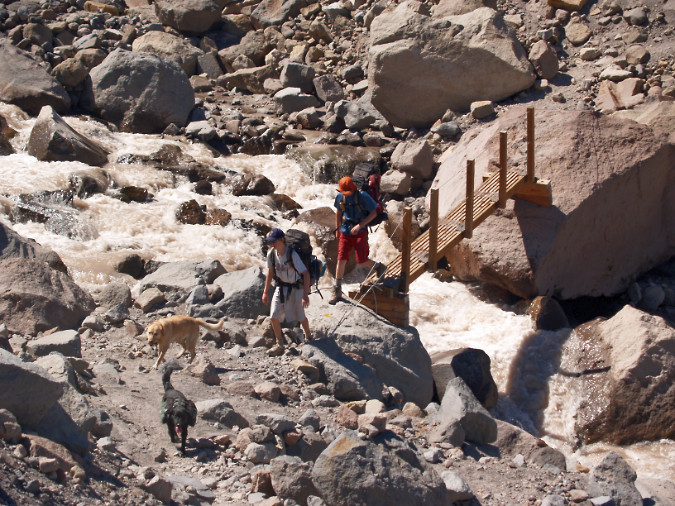
The Forest Service has some experience with seasonable bridges on the Timberline Trail. This seasonable crossing on the Eliot Branch was in place for several years in the 2000s
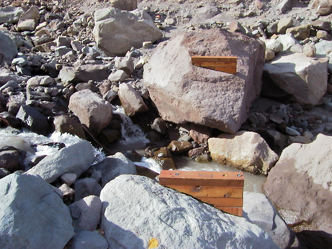
The design of the seasonal Eliot Branch crossing involved two footings bolted to boulders along the stream. This design was used within the designed Mount Hood Wilderness
It’s an idea worth exploring, as both resorts periodically renew their long-term permits to operate on public land with the Forest Service, and that’s a time when the public’s interest in their use of our lands is incorporated into a binding agreement. It’s encouraging the resorts are thinking beyond ski tickets, but it also a good time to acknowledge the commercial benefit they are receiving from public trails and ask them to step up and become a partner in making it a safe experience for everyone.
So, there are some ideas that could help us get unstuck from what is an intolerable situation on Mount Hood’s glacial stream crossings. Let’s not wait for another tragedy to point out the obvious: the glacial crossings are becoming increasingly dangerous and must be addressed, sooner or later.
Thanks for following the blog ! I hope to see you on the trail sometime!
_____________
Tom Kloster | August 2026
Postscript: have you visited the new companion WyEast Images Blog? Be sure to subscribe while you’re there!