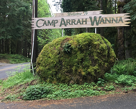
The giant boulder at the camp entrance is hard to miss!
Earlier this year, I attended a Trailkeepers of Oregon (TKO) event at Camp Arrah Wanna, a venerable youth camp located in the deep forests along the Salmon River, west of Mount Hood. The camp’s origins are a bit hazy, but today’s youth camp emerged from the Arrah Wanna Inn, one of many roadside hotels and restaurants that lined the Mount Hood Loop Highway soon after it opened in the early 1920s.
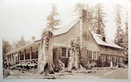
The original Arrah Wanna Inn as it appeared in the 1920s
During the heyday of the Arrah Wanna Inn, travelers explored the area in a growing network of trails to nearby forest lookouts and along the Salmon River. Locals also served as fishing and horseback tour guides to the growing stream of auto tourists.
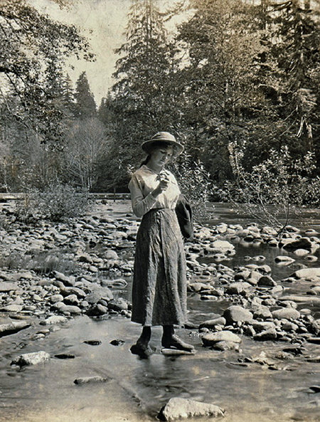
Early visitor to the Salmon River near Camp Arrah Wanna in 1915 (Wikimedia Commons)
Today, the camp hosts outdoor school each spring, faith-based youth camps in summer and winter and many other private retreats and events over the course of the year.
Today’s main lodge at the camp is housed in the historic Arrah Wanna Inn building. And though it has been decades since I spent my summers in high school and college working at camp, walking into the dining room in the main lodge brought back a flood of great memories.
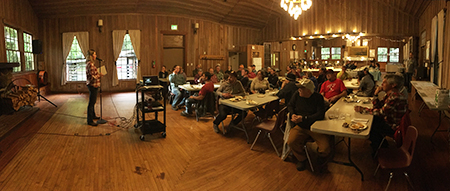
The rustic dining hall in the main lodge
Walking through the old dining room, something hanging above the east fireplace caught my eye: a huge watercolor panorama of the surrounding Mount Hood country!
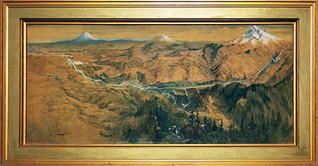
The panoramic masterpiece in the main lodge dining room
Panoramic, hand-tinted photos and paintings of Mount Hood were popular in the early 1900s, but this was different. This painting was intended so have some geographic accuracy, and is clearly a custom original. The frame and age of painting suggest that it was originally done for the Arrah Wanna Inn, and simply came with the building when Camp Arrah Wanna was established.
The artist behind this beautiful painting is unknown, though there may be a signature hidden inside the frame or on the back of the painting. The rest of this article is a tour of the details in this amazing, little known painting, section by section.
Taking a closer look…
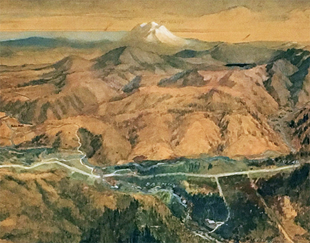
Close-up of the Salmon and Sandy River valleys with Mount Adams on the horizon
Front and center in the painting is the Welches community, known today as the Resort at the Mountain. Mount Adams appears on the horizon in this view, which is geographically correct. The large butte in front of Mount Adams in a mystery, however. My guess is that it reflects Hickman Butte, locked away behind the gates that close the Bull Run watershed to the public today, but the site of a prominent forest lookout in the 1920s, when I think this painting was made.
Looking more closely at the details in the Welches area, you can clearly see the Arrah Wanna Inn, which is why I believe this was created for the Inn as a custom artwork.
Detail of the Arrah Wanna Inn in the 1920s or early 1930s
In the foreground of the painting, a horseback party has arrived at a viewpoint overlooking the Salmon and Sandy River valleys (below). The artist has used some license here to place both Mount Adams and Welches in view, but in reality Mount Adams can only be seen from the upper part of Huckleberry Mountain. The long-unmaintained Arrah Wanna Trail did climb directly to Huckleberry Mountain, and there were viewpoints of the the valleys from sections of this old trail, so I think the artist simply merged these perspectives.
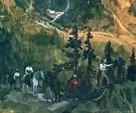
Detail of horseback party arriving at a viewpoint on Huckleberry Mountain
It’s hard to see, but the image shows a man leading five women and two horses to this viewpoint, with a second man bringing up the rear. We can only guess on the significance of the group — is it a biographical detail of the artist, perhaps? We’ll probably never know.
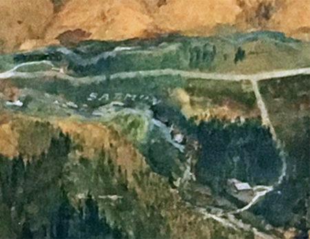
Also visible in this close-up look at the painting (below) is the Samuel Welch homestead and pasture that gave the community its name. The pasture was once known as “Billy’s Goat Pasture”, after Samual Welch’s son William, and today has been converted to be part of the golf course at the Inn at the Mountain.
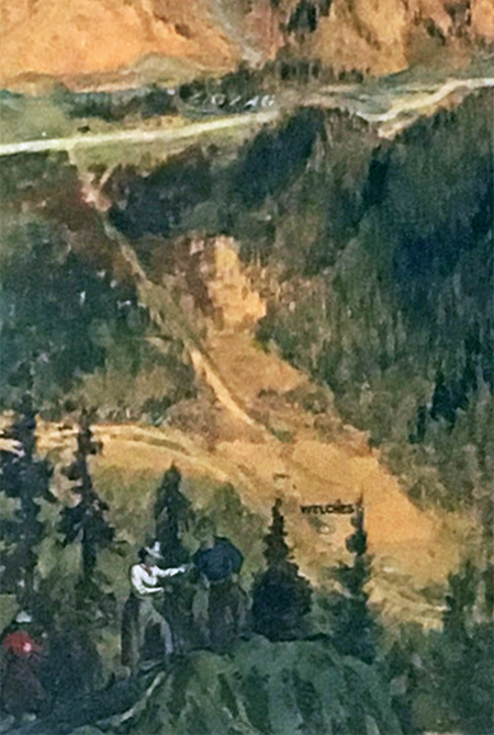
Detailed view of the Samuel Welch homestead that is today’s Welches community
Moving to the upper left corner of the painting (below), the artist included remarkable detail of Portland and the farm towns like Gresham, Powell Valley, Troutdale and Sandy that have since become suburbs.
Look closely, and you can see that the artist has carefully included Mount Scott, Kelley Butte, Mount Tabor and Rocky Butte in the painting details, as well as the Clackamas River, Cazadero interurban rail line, Columbia River and once-perfect cone of Mount St. Helens on the horizon.
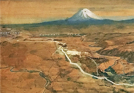
Mount St. Helens rising above the Sandy River eastern edge of Portland
These details show the artist to be a person with excellent knowledge of the area, since several of these features are in gegrpahically correct, but not actually visible from Huckleberry Mountain without floating a couple thousand feet above the summit.
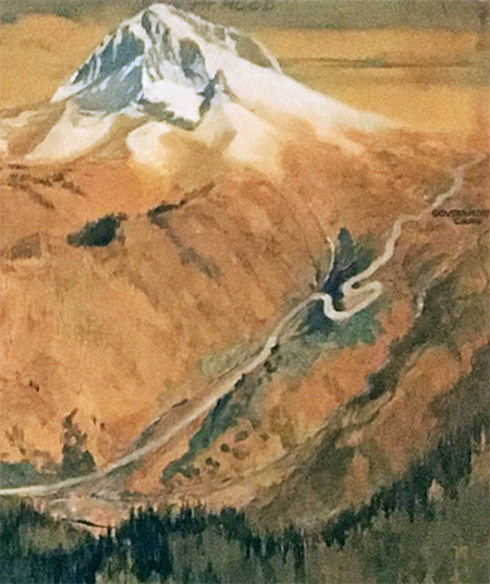
Moving to the right side of the painting, the artist has rendered a beautiful and very accurate portrait of Mount Hood (below). Zigzag Mountain — the long ridge in front of the mountain — is correctly shown as burned over. Lookout photos from the 1930s confirm that nearly all of this ridge burned in the early 1900s, though forests have largely returned today.
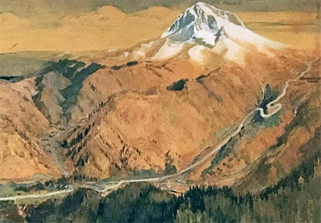
Beautifully rendered view of Mount Hood and the historic loop highway
A closer look (below) shows the confluence of the Zigzag and Sandy Rivers at today’s Zigzag community. The gray coloring along the Sandy River (approaching from the top) is also accurate to the period. In the early 1900s, the devastation from the Old Maid Flat eruptions of the late 1700s were still on display, as early photos show. Though mostly forested now, the valley floor was still a mostly open plain of cobbles and volcanic debris when the painting was created.
Detailed view of the Zigzag River confluence with the Sandy River
There’s another example of artistic license in this part of the painting, too. The large lake in the distance (below) appears to be Bull Run Lake, with Buck Peak rising behind it. The lake is completely hidden from the vantage point for the painting by intervening peaks and ridges.
Bull Run Lake is included in the details of this painting
I had to “fly” to over 18,000 feet — almost 3 vertical miles — above Huckleberry Mountain to actually see Bull Run Lake from this perspective. But the artist’s license in showing this detail is also another example of great knowledge of the area landscape, as the position of the lake is geographically correct. That’s a real feat in an era when only a few, small-scale topographic maps of the region existed!
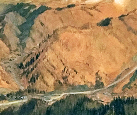
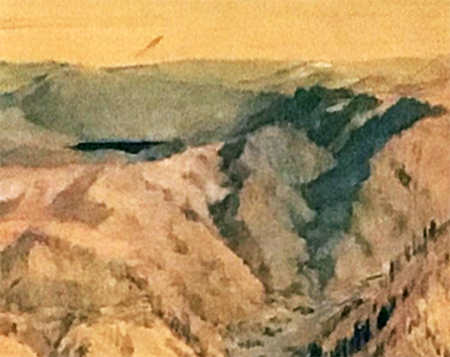
Looking more closely at Mount Hood and the loop highway where it climbs through the Zigzag Valley and up Laurel Hill to Government Camp (below) shows more terrific details. On the mountain, major features like Steel Cliff, Illumination Rock, Reid Glacier and Yocum Ridge are all included and proportionally accurate, with a bit of artistic license. If you look very closely, you can even pick out Cathedral Ridge, McNeil Point and Barrett Spur, all of which are geographically accurate from the vantage point of Huckleberry Mountain.
Mount Hood and the Zigzag Valley
Looking very closely at Laurel Hill and the highway approach to Government Camp (below), the old loops on the historic highway are shown in great detail, along with the Little Zigzag River at the first highway switchback and Yocum Falls on Camp Creek to the right of the third switchback. The burn details are also correct, here, as most of the area around Government Camp had burned and was just beginning to recover in the early 1900s.
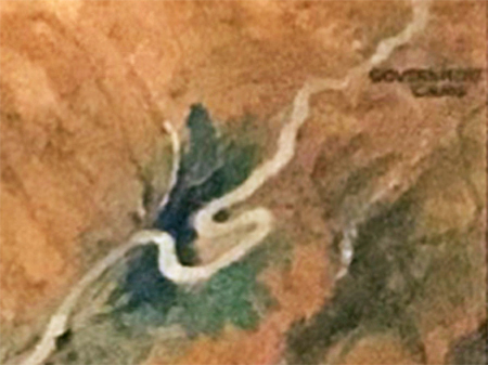
Detailed view of the historic loop highway where it climbs Laurel Hill to Government Camp
The kind staff at Camp Arrah Wanna allowed me to share these images, and hopefully they will satisfy your curiosity, as well. The camp is a non-profit operation, and not really equipped to handle tourists dropping by to admire old paintings! But if you or an organization you belong to is looking for a site for a retreat or gather, consider supporting Camp Arrah Wanna! It’s one of the real gems on the old highway circuit, and relies on event bookings to keep this beautiful slice of history alive.
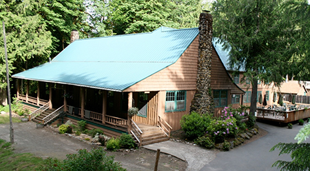
The historic Arrah Wanna Inn is now the main lodge at Camp Arrah Wanna (photo: Camp Arrah Wanna)
You can learn more about Camp Arrah Wanna and find contact information here:
24075 E. Arrah Wanna Boulevard
Welches, Oregon 97067
I’m also able to share even higher resolution images of the painting than what I posted for this article. Please reach out to me if you’re interested.

thanks for sharing. Real interesting. Chris
LikeLike