Memaloose Road had a rough winter…
Attention geomorphology nerds! (and if you didn’t have to Google that word just now, consider yourself one!) The aftermath of an impressive micro-geology event that unfolded over the winter is on full display along Memaloose Road, in the Clackamas River canyon.
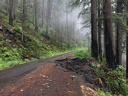
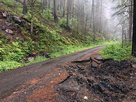
Less than a mile from the Memaloose Bridge over the Clackamas River, a huge new crater appears in the paved road. I stumbled upon the scene a couple of weeks ago, while traveling up Memaloose Road to document the forest recovery from the 36 Pit Fire.
This is no landslide… it’s a crater!
The human-caused fire (started by target shooters, sadly) burned 5,520 acres of the lower Clackamas River canyon in September 2014, including the newly protected wilderness in the South Fork and Memaloose Creek canyons.
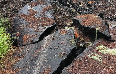
At first, I assumed this to be a landslide triggered by the fire burning away vegetation that normally holds down soil on the steep canyon walls. But upon closer inspection, this was clearly an impact crater, not a slide. A 15-foot wide hole has been punched through six inches of asphalt, leaving a 4-foot deep crater in the road!
A few minor repairs may be in order, here…
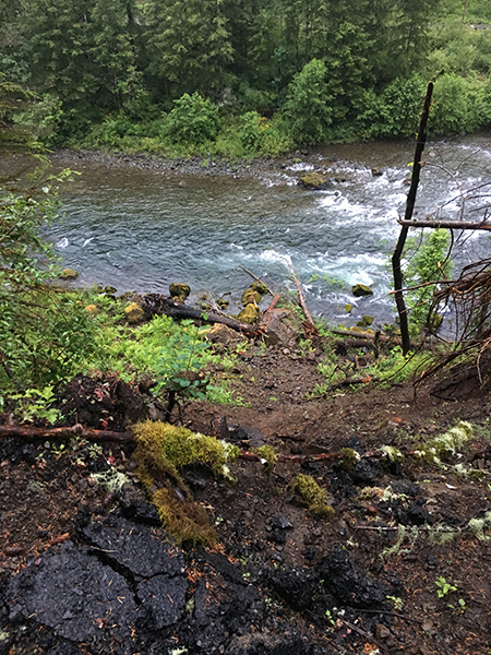
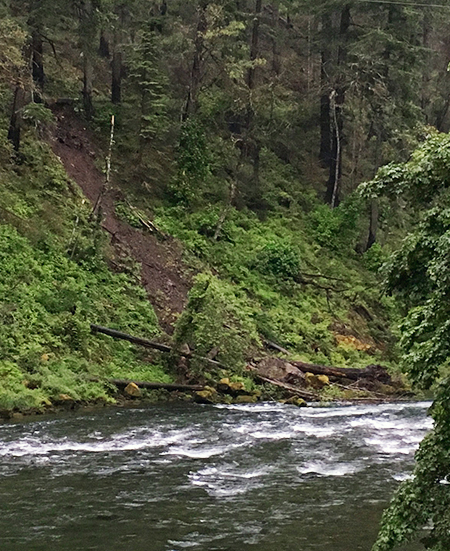
At first, I thought a large, falling tree might have somehow torpedoed the road, but looking downslope toward the Clackamas River, the culprit was in plain sight. A van-sized boulder had rolled down the slope and is now lodged against the south bank of the river!
Path of destruction… and the answer to the crater mystery!
The boulder did a thorough job of clearing the slope in its path, but what struck me in looking at it from above was just how ordinary this boulder is in comparison to the thousands of mega-boulders that dot the Clackamas River. In this way, the rolling boulder at Memaloose Road is a nice glimpse into the everyday shaping of the canyon, where countless events like this have carved the landscape we know today.
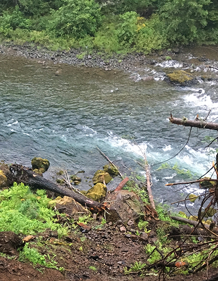
The big, bulldozing boulder resting in its new, riverfront home. For scale, the freshly skinned logs lying next to the boulder are a 18″ or more in diameter. The nearby moss-covered rocks were in place before the rock fall, and may have helped block the new boulder from rolling further into the river.
So, where did the new boulder come from? A view up the slope from the fresh crater tells the story. A low, 30-foot basalt rim lines the top of the canyon wall, and the path of destruction to the road is plainly marked by a mowed-down understory and several shattered trees (below).
Through sheer gravity and cracks that form in the basalt layer, boulders like the one at Memaloose periodically break loose. This is the ongoing erosion process that has played out for millennia in the Clackamas River canyon, and it’s a great opportunity to see this process playing out in real time.
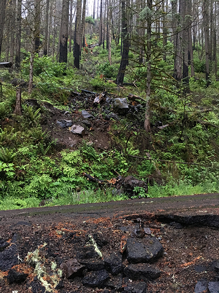
The path of destruction above the road.
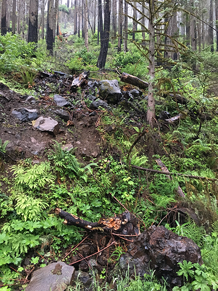
Part of me wishes I could have been here to watch the big boulder blast this path, especially when it reached the road cut, which worked like a ski jump to launch the boulder into the air, landing it on the outside edge of the road and creating the impact crater. Wow, what a spectacle! Well, maybe from a safe distance, anyway..!
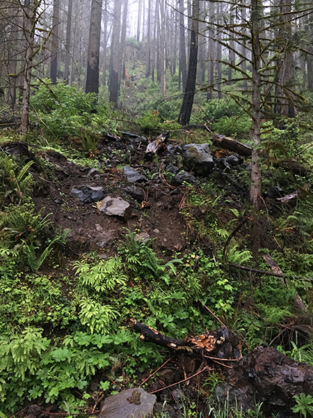
The best seats in the house for this event were at the base of the road cut, where a colony of Maidenhair Ferns grow along the road (below). They watched the giant, airborne boulder soar overhead, yet managed to miss its wrath. If only ferns could talk…
The “jump” that launched the huge boulder into space.
A closer view of the path of destruction, including several smaller boulders and trees that were brought down the by the big boulder…and the lucky colony of Maidenhair Ferns.
This view (below) looking downhill and toward the Memaloose Bridge (in the background) gives a sense of the size of the crater, and what the impact must have been like. Fortunately, my car wasn’t parked there at the time (…though it does have the required Forest Service trail permit on the dash…) The big Douglas Fir on the left was narrowly spared by the big boulder, and also survived the 36 Pit Fire to hopefully live for many more years. The boulder could have easily snapped this 4-foot diameter tree, and did crush other large trees in its path.
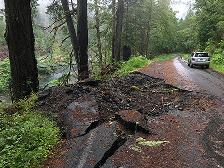
The crater with the Memaloose Bridge and Clackamas River in the distance
The rolling boulder can also be seen from Highway 224 (below) on the opposite side of the Clackamas River, where the path of destruction and jumbled pile of trees and smaller rocks and boulders gives a hint of what happened here.
The big boulder and its path of destruction from the opposite side of the Clackamas River
On the way out, I noticed a fresh pile of gravel at the south end of the Memaloose Bridge, which suggests that road repairs are imminent. So, if you enjoy forensic geology and seeing Mother Nature at work*, stop by the Memaloose Road sooner than later!
How to get there…
The boulder roll took place just off Highway 224 and makes for a short and interesting side trip if you’re headed for a hike further up the canyon. Memaloose Road is easy to find, too. Follow Highway 224 to Estacada, then continue approximately 9 miles to the Memaloose Bridge, where you will turn right to head across the bridge and up Memaloose Road. This is a 1-lane bridge and road – watch for log trucks! The boulder crater is less than a mile up Memaloose Road.
Oh, and watch your step when checking out the crater… it’s a long slide down to the river!
______________
*Mother Nature does, indeed, bat last… always…

Thanks Tom! We’ll take a look the next time we head up the Clackamas.
So does this mean the gate at the south end of the bridge and the one 3 miles up the hill are now open? They’ve been locked for several years, if I’m not mistaken.
LikeLiked by 1 person
Thanks, Jerry! Yes, the gate is open — I was able to travel several miles up the road, and the only obstacles were the crater and a large stump lying in the road just beyond the crater — passable on the left without a problem. Enjoy!
LikeLike
Tom, I think you got lucky and gate was only temporarily open per recent discussion on Oregon hikers forum.
Say, I have some possible blog fodder for you: the (former) Robinhood Campground on Hwy 35. I wandered through there yesterday and it was fascinating and eerie. the flood damage and what once was. we were thoroughly exhausted after hiking Bluegrass Ridge and diving down a 2000 ft bushwack from Elk Mountain, or we would have explored more. Plan to go back during shoulder season. Check it out if you haven’t already!
LikeLiked by 1 person
Thanks for the heads-up, Jen! Glad I didn’t get locked in… hopefully it will stay open more often than not this year. I’ll check out Robinhood CG, too — thanks!
LikeLike
Excellent! Those maidenhair fern were very fortunate not to get flattened.
And yes, Mother Nature ALWAYS bats last. Certain people (nobody reading this message) would do well to remember that…
LikeLike