
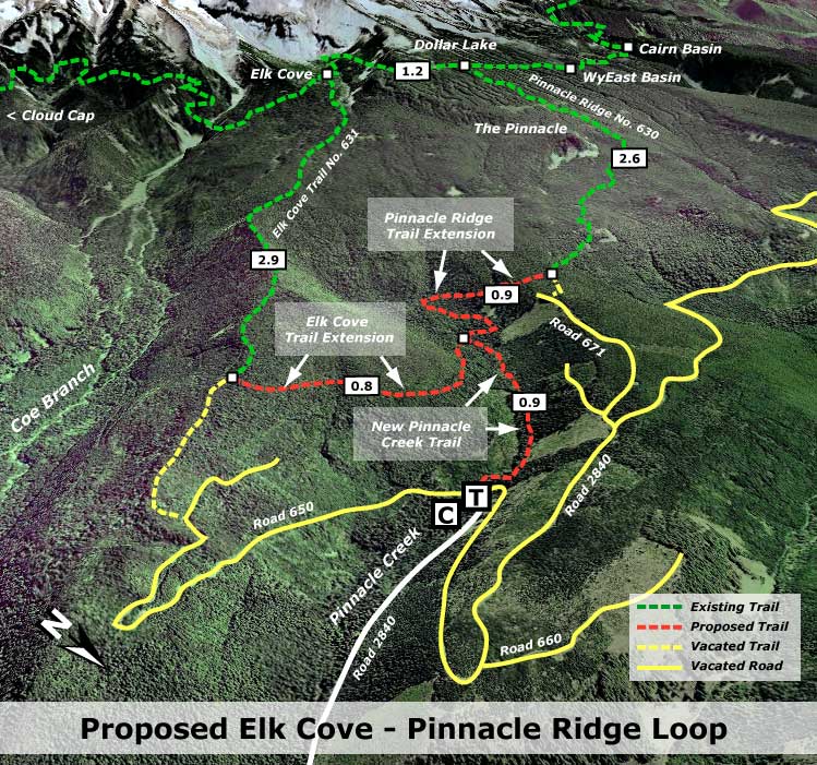
This proposal calls for a new trail connector linking the historic Elk Cove Trail (No. 631) and little-used Pinnacle Ridge Trail (No. 630) on Mount Hood’s rugged north side. This new connector would create a new 9.3 mile hiking loop that could serve as a strenuous day trip for experienced hikers, or an easy overnighter for casual hikers and families.
The new trail would also allow for eventual decommissioning of at least nine miles of deteriorating logging roads (shown in yellow on the maps that follow), as the new connector would provide access to both trails from the lower Elk Cove trailhead at Pinnacle Creek, on Forest Road 2840. In this way, the proposal not only provides an ecological net benefit in restoring the area from its logging heyday, but also pays for itself in reduced life-cycle costs for forest infrastructure.

About half the nine miles of logging roads already fall within the newly expanded Mount Hood Wilderness, so will probably be abandoned without formal decommissioning by the Forest Service.
However, a substantial portion of the old road system falls outside the wilderness boundary, within the Pinnacle Creek drainage. Without the wilderness restrictions, this portion could be decommissioned using traditional machinery, thus providing a significant ecological benefit for the watershed. This would be important in any watershed, but is especially important here, where Pinnacle Creek forms a critical spawning ground for Clear Branch Bull Trout, a local species whose status the Oregon Department of Fish and Wildlife described in 2006 as “highly precarious”.

Clear Branch Bull Trout (ODFW)
Part of the old logging network also includes the first mile of “trail” that currently leads to Elk Cove. In the late 1990s, the Forest Service relocated the Elk Cove Trailhead to the current location when Pinnacle Creek washed out the road where it crossed the stream. Since then, a footbridge has replaced the old road over the creek, and the “trail” has been an increasingly brushy, mile-long walk up the truncated road on the opposite side.
This messy section of “trail” is a reminder that road-to-trail conversions may seem an attractive bargain in the short run, but are often substandard for the outdoor experience they provide. Worse, over the long-term they can become brushy thickets of alder and willow, making them more costly to maintain than a traditional trail built under established forest canopy.

Overgrown “trail” to Elk Cove is actually a road
This proposal also responds to a road closure project floated by the Forest Service in early 2010 to “provide public access to the Pinnacle Ridge and Elk Cove trails after Road 2840 is decommissioned near Kinnikinnick campground.” The Forest Service project would close Road 2840, converting much of it to trail, and thus adding another mile of road walking to the Elk Cove Trail in the process. Worse, a full 3.5 miles of road walking would be required to reach the current Pinnacle Ridge Trailhead.
In both cases, this amount of road walking is an unacceptable way to provide a quality wilderness experience on two important gateways into the Mount Hood Wilderness. The proposal in this article was submitted to the Forest Service as an alternative, however, the Forest Service project has since been withdrawn, according to their website. Hopefully, this will provide more time to make the case for a better trail solution, since their own watershed management plans call for eventual closure of most logging roads in the area (more about that, later).
What Would it Look Like?
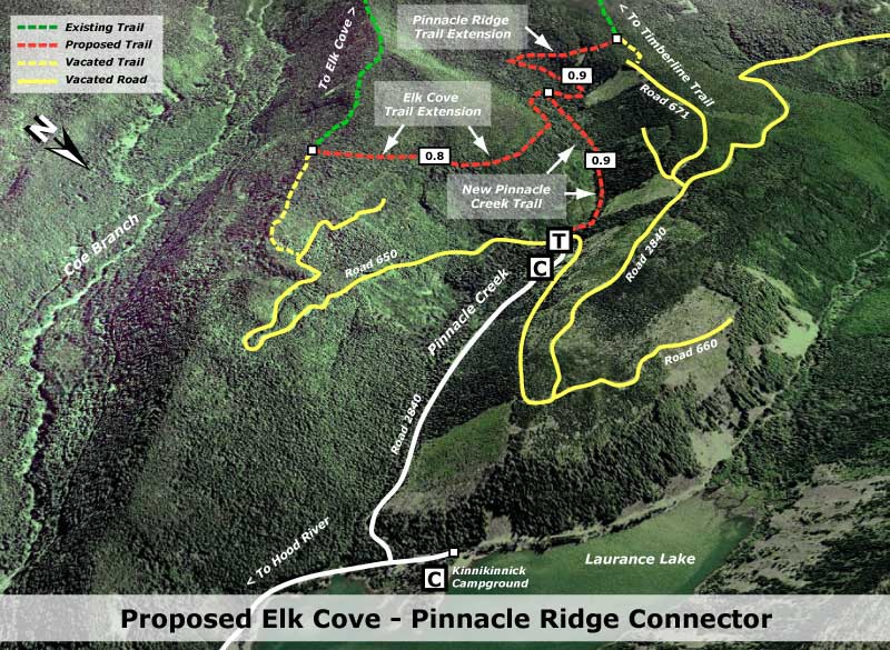
The proposed new trail would begin at the existing Elk Cove Trailhead, along the banks of Pinnacle Creek (see map, below). Though the trailhead, itself, is not in need of significant improvements, the informal campground at the trailhead would be formalized as a tent camping area under the proposal. This would allow for weekend or overnight visitors from Portland or points beyond to arrive late, spend the night at the trailhead, and begin day or backpack trips early the next day.

Where the existing Elk Cove Trail currently heads east, up the truncated Road 650, the proposed new Pinnacle Creek Trail would instead follow rushing Pinnacle Creek southwest for 0.9 miles to a new junction, where a pair of new connections would climb east to the Elk Cove Trail, and west to Pinnacle Ridge Trail. (shown in red on the map, above). The new Pinnacle Ridge Trail would need to sidestep old clearcuts on both sides of the creek, but would easily fit within the intact forest of the riparian corridor, providing a quality, streamside hike.
The second map (below) shows how the new connector trails would create a 9.3 mile Elk Cove to Pinnacle Ridge loop for day hikes and overnight trips, with campsites at Elk Cove, Dollar Lake and WyEast Basin. The new loop opportunity would not only make better use of the lightly used Elk Cove and Pinnacle Ridge trails, but also provide a north side access alternative to the very heavily used trailheads at Vista Ridge and Cloud Cap.

For accessibility, the Elk Cove trailhead has the added advantage of being reached mostly on paved roads, with only the final mile on an unpaved road. This represents a substantial improvement over the long, rough ride required to reach both Cloud Cap and Vista Ridge.
The new connector trails would also provide an important aesthetic improvement to the logging road trudge along the first mile of the Elk Cove Trail — a disheartening way to begin (and end) what is otherwise a premier alpine hike.

Mount Hood from the dramatic Coe Overlook
These new trails would also provide a higher quality day hike to the little-known Coe Overlook for less experienced hikers, with a 2.3 mile, 1,500 foot climb from the trailhead to the viewpoint. This moderate hike would feature a mile of streamside hiking, virgin subalpine forests and the spectacular view of the north face that the viewpoint offers.
What Would it Take?
This new trail proposal could be largely designed and built by volunteers. Access to the work site is easy, and open from late April through early November, providing an extended season for volunteer workers. The added benefit of linking the trail project to road decommissioning would make this an excellent candidate for groups like Trailkepers of Oregon to consider.
Logistically, the lower Pinnacle Creek valley is located outside the Mount Hood Wilderness, allowing volunteers to use power equipment for trail construction, where needed, with few limitations on trail structures (such as bridges).

Elk Cove Trail at Pinnacle Creek
At this time, it is unclear why the Forest Service has withdrawn their proposal to close and convert Road 2840 to a trail, since the project was driven by a watershed restoration mandate. But if the project is reactivated, we can all have an impact on the reconfigured trail system by weighing in — and simply forwarding this alternative proposal is a way to achieve much better results.
In the meantime, both trails are well worth the extra effort needed to reach the trailheads if you are looking for a different approach to Mount Hood’s north side. Both are described in the Portland Hikers Field Guide:
Pinnacle Ridge to Elk Cove Hike
Depending on how the snowpack shapes up this year, both trails should be open by mid-July, and provide a great way to visit the mountain! Meanwhile, watch this blog for further Forest Service developments in the Pinnacle Creek area, and opportunities to weigh in.
