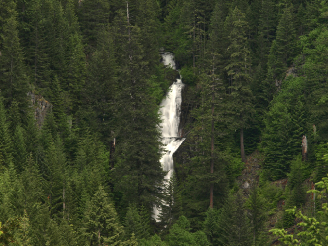
Devil Canyon holds one of Mount Hood’s best waterfalls – known to only a few, despite being less than a mile from busy traffic on US26
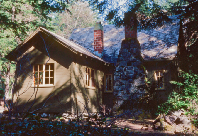
Growing up in Portland in the 1970s and 80s meant many trips to a family cabin on Forest Road 35A, along the Zigzag River. My folks eventually sold the place when I was in my 20s, and simply owning a house was still way out of reach — much less a second home on the Zigzag River. How I would have loved to keep it in the family, but alas, I have only fond memories and a few photos to remember our family cabin.
It’s still there, though, toward the turnaround at the end Road 35A. It’s a rustic, hand-crafted gem built in the 1930s on Forest Service land as part of the 99-year lease program. When my family bought it, the place was completely furnished with original pinewood furniture, a cast iron cook stove, 1930s dishes and cookware, a shelf of vintage board games and colorful, coiled rag rugs of the era scattered throughout. There was even a small bookcase stocked with Zane Grey paperbacks and old guidebooks and maps of the Mount Hood area! It was like a living museum.
The family cabin on Road 35A in the late 1970s, after much TLC from the family to restore it to its original condition.
Only after the cabin was sold in the early 90s did we learn of its dark past. It turns out the prior owner had been a loner who tragically ended life there with a shotgun – and wasn’t discovered for several weeks thereafter. Thus, when my family bought the cabin “furnished, as is”, it included a rather grisly scene in the downstairs bedroom, along with all those vintage 1930s furnishings that took on a new meaning.
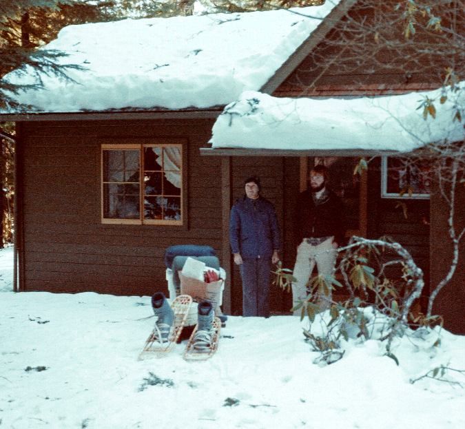
Road 35A was (and is) barely maintained by the Forest Service, much less plowed in winter. Instead, we often parked along US26 and made the trek to the end of the road on snowshoes, pulling food and gear on toboggans. This photo of me and mom is from the winter of 1980-81 when I had just turned 18 and started college
This very late revelation about the cabin’s secret past did explain several parents-only trips in the very beginning, when we were told the place “needed some repairs” before the kids could join them up there. Dad was a physician, so making those “repairs” were all in a day’s work for him, as he later described to us in all-too-graphic detail the scene they found on their first walk through the cabin.
In retrospect, the rest of the family was relieved to have been spared this grim backstory over those many years of vacations and holidays spent at the cabin — though much speculation followed on whether the occasional bumps and footsteps heard in the middle of the night were really just our imagination..?
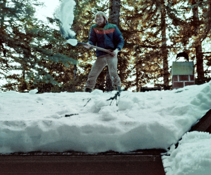
The best reason to bring your teenager home from college along to the cabin – aside from hauling heavy toboggans loaded with food and gear? Shoveling snow off the roof, of course! This is also a scene from the winter of 1980-81, and I’m not even sure how I got up there safely, much less got back down…
It was during those years at the Zigzag cabin that my passion for the mountain really took off. In winter, it was a base camp for skiing and snowshoeing. In summer, I roamed the trails and forests in all directions, mostly alone (still my preferred mode). Dad picked up a copy of Jack Grauer’s classic “Mount Hood – A Complete History” that we kept up at the cabin, and I devoured every page. I still read it often. I was – and still am – infatuated with Mount Hood!
The most popular trail in the area was a short loop at the end of Road 35A that climbs to a rocky bluff high above the Zigzag River. Called “High Rocks” by the cabin community, the outcrop gave fine views of Mount Hood, nearby “Silent Rock” – the highway cut where US26 begins its ascent of Laurel Hill — and Tom Dick and Harry Mountain, beyond. Though I haven’t hiked it in years, the rustic loop trail is no doubt still there, and still maintained by cabin owners.
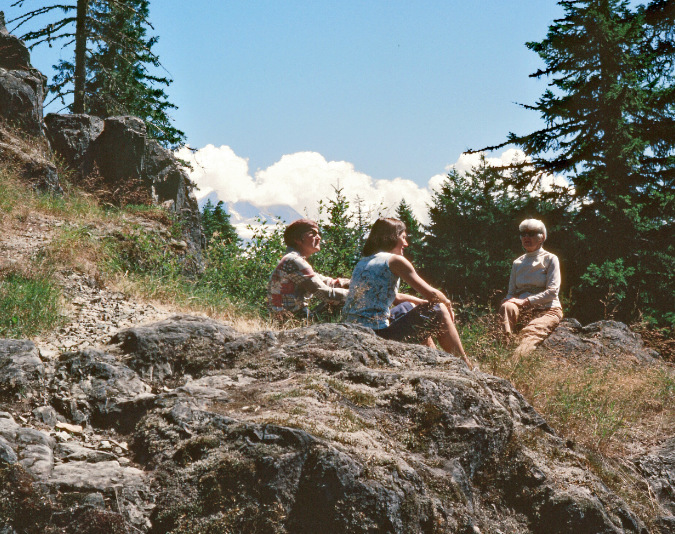
I took this photo of mom (center), my Great-Aunt Mabel (right) and Mabel’s ”best friend and companion” Pauline (left, and we would say her “partner” today, social mores having thankfully evolved). They were enjoying the view from “High Rocks” on one of their visits to Oregon in 1982. Mount Hood is peeking out from the clouds in the distance, and the Zigzag River flows directly below these 100-foot cliffs
Beyond the High Rocks loop, a lesser-known trail network was developed and maintained by a longtime cabin owner who I only knew by his old-school hiking staff and the Scottish tartan vests and cap he wore. If I could teleport in time, I’d retrieve the copy of his hand-drawn trail map that hung on the ancient refrigerator in our Zigzag cabin, as it included all sorts of unofficial trails linking into the surrounding Forest Service system.
Thankfully, I do remember most of those trails, and one in particular that could be useful today (more on why in a moment). It was called “The Tripod Trail” and left the High Rocks loop to climb a still high bluff to a viewpoint of the Zigzag Valley. The old map also noted a mysterious waterfall, located just below the Tripod Trail where it traversed into Devil Canyon. Intriguing!
Most of the old Tripod Trail followed an old logging grade that scaled the bluff in switchbacks. The often-faint trail was marked by simple stick tripods tied with twine that gave the trail its name. From the end of the logging grade at crest of the bluff a user trail continued north, eventually crossing Devil Creek and connecting to the West Zigzag and South Burnt Lake trailheads at the upper end of Forest Road 27 – also known as Enola Hill Road. During those years at the Zigzag cabin, this was my direct, unofficial access from the cabin door to the Zigzag Mountain trail network and the Mount Hood Wilderness.
Today’s Road 27 Dilemma
Road 27 begins about a mile west of Road 35A. Starting from US26, it also crosses the Zigzag River, then briefly parallels the river heading upstream to provide access for a small group of Forest Service summer cabins. Soon the road makes a hairpin turn, reverts to an unimproved dirt surface and launches up the steep face of Enola Hill along a very narrow, winding traverse. This is the nerve-wracking section the road is most notorious for.
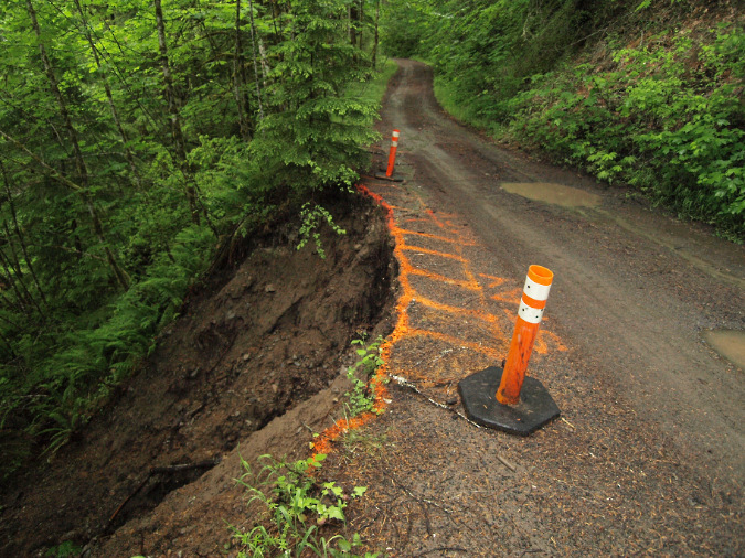
The lower portion of Road 27 is (in)famous for its periodic landslides and nerve-wracking drop-offs…
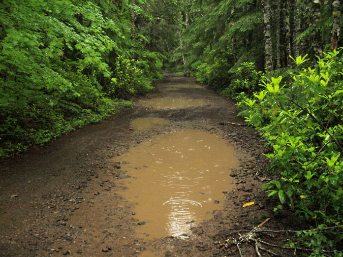
…while the upper portion is known for its sprawling mudholes
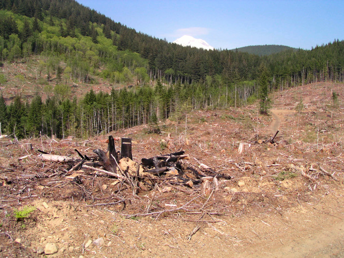
Near the top of Enola Hill, the road flattens out as it crosses a large inholding of private land on a flat bench above the hill. These and other private lands on the hill have been brutally logged many times over, a source of legal disputes with area tribes. However, the private land owners have never attempted to limit general public use of the road where it passes through the private inholding. Until now.
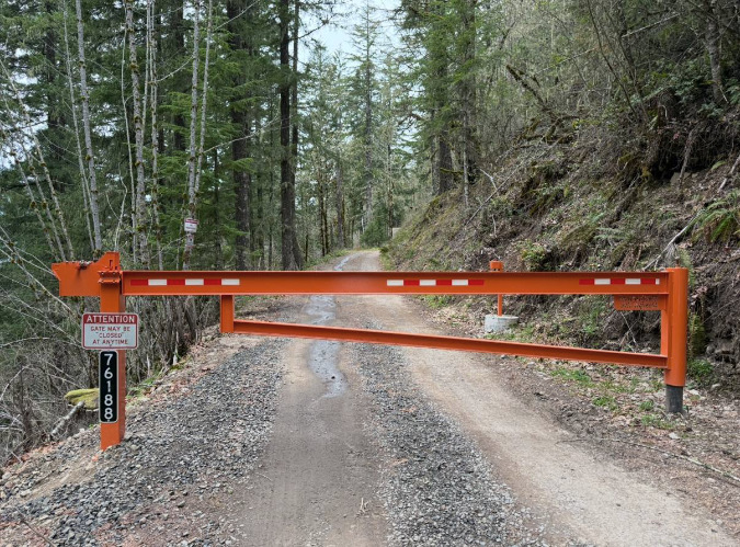
This gate abruptly appeared on Road 27 last year. Signs posted just beyond warn of private property and surveillance (photo: Jerry King)
Through a legal and bureaucratic saga too long and frustrating to summarize for this article, the Forest Service apparently has no means to remove a gate that was abruptly installed by the private land owners last year. This has caused much angst among hikers who fear losing the trails accessed by Road 27 forever, as well as folks in the Rhododendron community whose Henry Creek water source originates on Enola Hill, and is also reached via Road 27.
Can you spot the private land in this view from Road 27? Mount Hood peeks over protected public forests in the distance, within the Mount Hood Wilderness that border these private parcels.
There are good arguments for figuring out a solution and reopening the gate to the general public, though the chances do seem slim. Fortunately, the Rhododendron community appears to have worked out access to the Henry Creek watershed. However, it’s unclear whether even emergency responders have access, should there be a need for search and rescue crews or other responders. The rest of the public is simply left out in the cold after nearly a century of enjoying access to our national forest lands on this road.
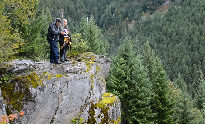
Tribal leaders survey Devil Canyon from the rocky viewpoint atop Enola Hill during their years-long dispute over a nearby highway widening project that destroyed a spiritual site (the tribes finally won a settlement in that case from the federal government in 2023). Devil Canyon Falls can be seen in the distance (photo: Beckett Fund for Religious Liberty)
Despite these frustrations, there are some real benefits to this road finally being closed. That’s the focus of this article. At the top of the list is the spiritual significance of Enola Hill to local tribes, a concern that has led to prolonged legal disputes over past decades with the Forest Service and the Oregon Department of Transportation.
Though the tribal interests cover a larger area surrounding the hill, the spot that most anyone can appreciate as sacred and worth protecting is the rocky outcrop on the east end of the hill, where views sweep from Devil Canyon Falls to Laurel Hill, and to the broad Zigzag Valley, below. The overlook is located National Forest land, and until last year, the tribes enjoyed open, public access to this revered spot, along with everyone else.
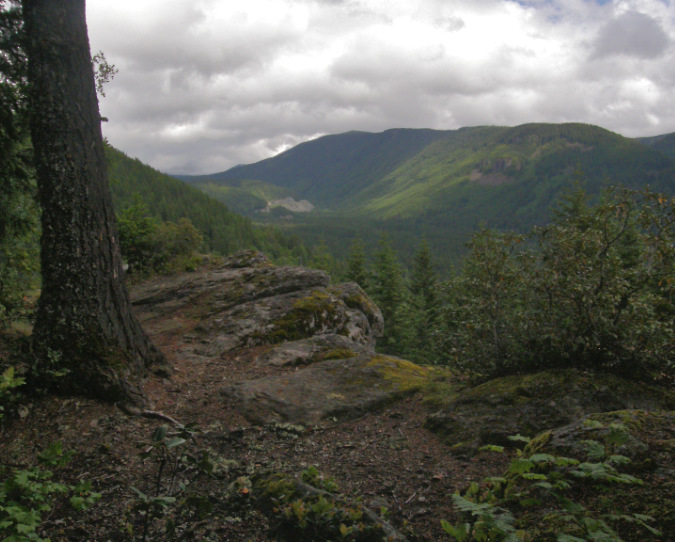
A short path leads to the dramatic overlook on Enola Hill, with the Zigzag Valley spreading out below and Tom Dick and Harry Mountain in the distance in this view
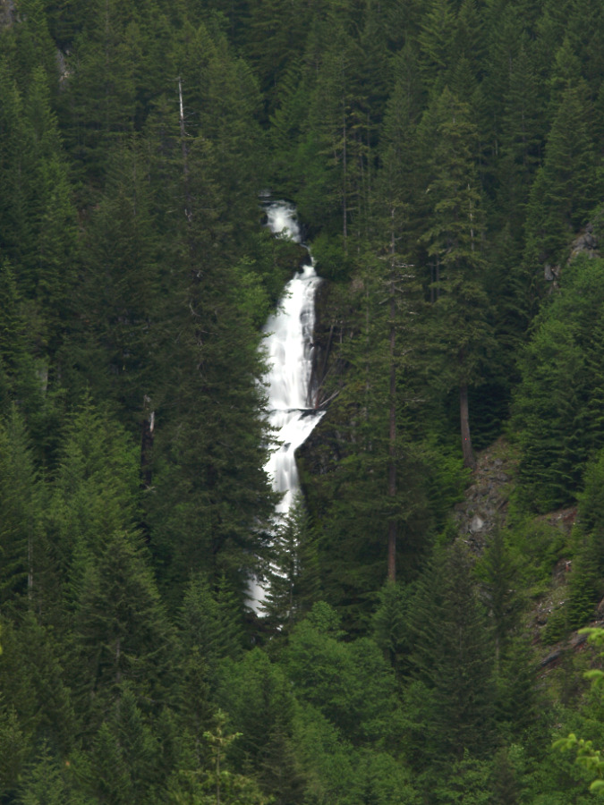
Devil Canyon Falls is the show-stopper from the Enola Hill viewpoint, the only spot where the full extent of the 3-tiered falls can be seen and heard
However, despite its beauty and cultural significance, the rocky viewpoint on Enola Hill has the misfortune of being just a few yards from wide pullout on Road 27 that has long attracted target shooters, off-roaders and other bad actors who routinely left their trash and broken glass behind. The gated road has at least given the culturally important area a reprieve from this ongoing problem.
The road itself is a also maintenance liability to a Forest Service already overburdened with a sprawling network of deteriorating logging roads. The steep, lower section is prone to landslides and blowdowns and parts of the upper section can be a 3-season muddy quagmire. Though its condition was always primitive, simply keeping it open remained a chore.
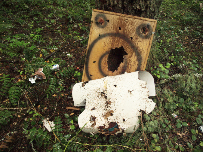
Forest roads bring shooters, dumpers and illegal off-high vehicle activity. Road 27 is no exception, as evidenced in this scene just steps away from the Enola Hill viewpoint
Times have also changed the need for Road 27. Beyond access to the private inholdings, the road no longer serves its original purpose for logging and as a route to the long-gone Devils Meadow Campground. Today, most of the public lands along upper Road 27 are protected as wilderness, and thus the road will never again serve commercial logging on public lands here. Its sole remaining public function is access to the West Zigzag and South Burnt Lake trailheads into the Mount Hood Wilderness.
Before the gate closure last year, the reputation of Road 27 as a rough, sketchy road with some rough, sketchy characters hanging out along it kept many hikers away from the trailhead, and this may have been one of the motivations for the gate. Simply reopening the road would likely revert to the same, sketchy status quo. In this way, the gate closure provides an opportunity to create a better option for hikers: to finally bypass the road entirely with a new Devil Canyon Trail.
Into the canyon…
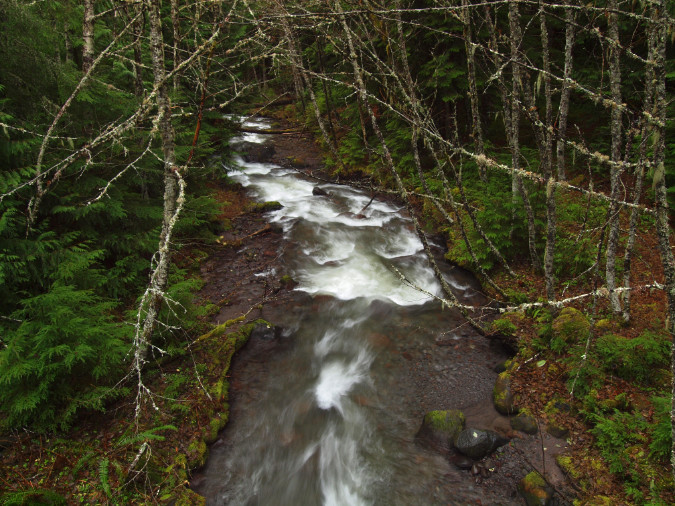
The idea of accessing the wilderness with an official trail that begins somewhere along the Zigzag River has long been on my mind – ever since that old sketch map that took me up the Tripod Trail. In those days of exploring the area, I’d also made my way up Devil Canyon from below, fascinated by the steep, rambunctious stream and the mystery of a big waterfall upstream – and I wondered why there wasn’t already a trail here?
Decades later, I finally returned to Devil Canyon with a group of friends on a mission to reach the falls, this time with the dream of a new trail passing right in front of the waterfall on the way to the West Zigzag and South Burnt Lake trailheads. Though it had been 30 years since I last explored the area, it was exactly as I remembered it.
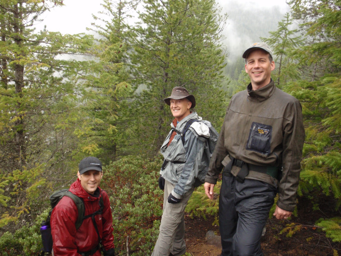
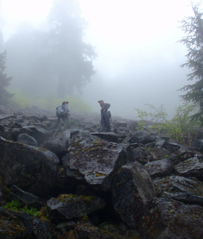
Intrepid waterfall hunters Jamie, Don and Ted getting ready to descend into Devil Canyon a few years ago
Following my memory of the old sketch map, it didn’t take long before we found the upper end of the Tripod Trail along Road 27 – well above both Enola Hill and the falls – and followed it down to a very well-used (and flagged) log crossing of Devil Creek. From there, the obvious path took us along the east rim of the canyon, as the stream below us dropped steeply and noisily toward the falls. Soon, we left the Tripod Trail and followed our ears deeper into the canyon.
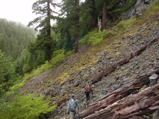
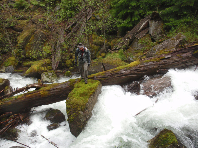
Picking our way across the broad talus slope that borders Devil Canyon Falls
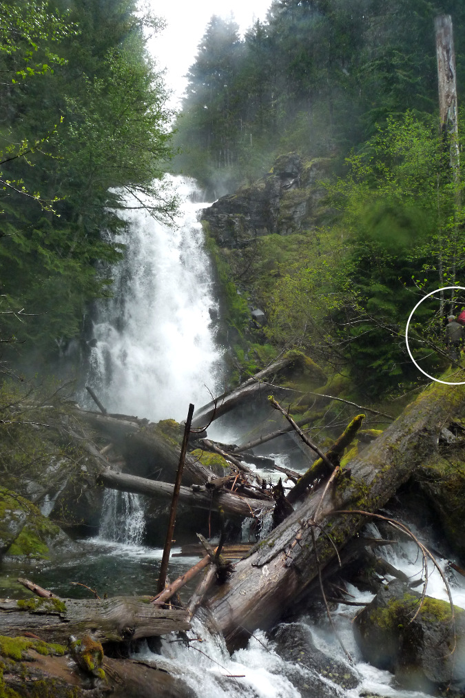
The final descent to the falls was down a tall, steep talus slope. We couldn’t see the falls until we were nearly at its foot, and it was raging in an unusually wet June. I had pictured a tall, stairstep cascade, up-close, something like Wahkeena Falls in the Gorge, but the steepness of the canyon meant that we could only see the final 90-foot tier of the falls from below.
It turned out the best view of the falls was from that rocky viewpoint on Enola Hill, though finally standing at its thundering base was exhilarating, indeed! Red alders crowded the stream and waved in the blast of mist blowing downstream from the falls. Piles of car-sized boulders and massive logs jammed the stream and ancient groves of Douglas fir towering above, giving the scene a remote, primeval feel.
As close is this spot was to the rush of the outside world, it was truly wild. Maybe it really would be best to keep the view at a distance?
The lower of three tiers that make up Devil Canyon Falls. The canyon contains stands of ancient Douglas fir, with a few fallen giants lodged in the stream. Ted and Jamie are standing on the huge log in this view – circled for scale.
Thus, my daydream of a streamside trail ascending to a front-row viewpoint of the falls was fading fast in that rugged, wild canyon. As we made our way back up the steep talus slope to the Tripod Trail, I began to think about other options for a new connecting route to Zigzag Mountain.
Climbing out of Devil Canyon and into the mist – and back to the Tripod Trail.
From the top of the talus slope, we had a good view of the west canyon rim, behind us. A series of flat-topped cliffs extended north from the Enola Hill overlook, possibly providing more waterfall views from along the way. These cliffs could offer a scenic rim trail route if the Forest Service were to go big and design a new trail to bypass the Road 27 dilemma. Meanwhile, the Tripod Trail we were following on the east side of the canyon was clearly an option, as well.
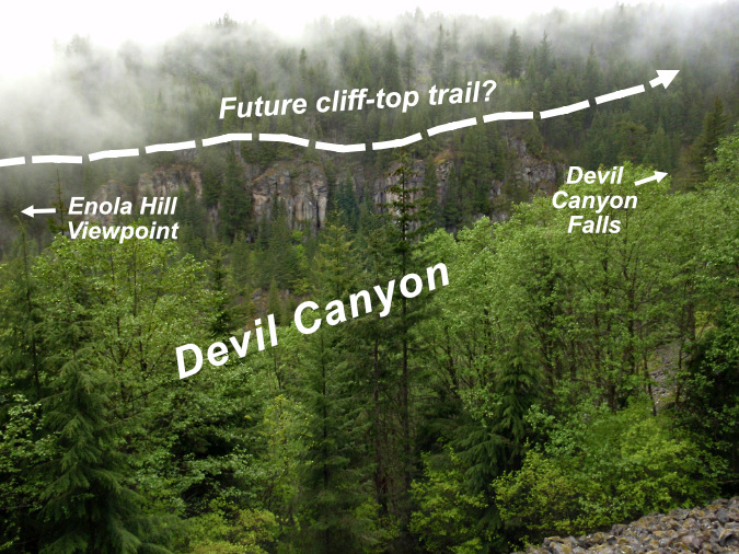
Looking across at the cliff tops on the west side of Devil Canyon that could provide a new wilderness trail connecting route
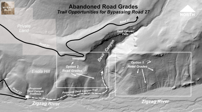
Back home from our canyon adventure, a closer look at LIDAR imagery (below) showed the Tripod Trail alignment nicely, where the ascent section climbs the wall of the Zigzag River valley on a well-built logging grade as it switchbacks up the slope. The user trail that continues from the top of the logging spur to Road 27 doesn’t show on Lidar, but it’s plain as day on the ground, and mostly follows a level bench above the canyon. An official Forest Service trail along this route to bypass Road 27 seems straightforward.
[click here for a larger map in a new window]
The LIDAR image revealed yet another surprise option: a series of old logging grades that climb Enola Hill, on the west side of the canyon. These would provide an even better opportunity for a low-cost trail alternative to the Tripod Trail that bypasses Road 27.
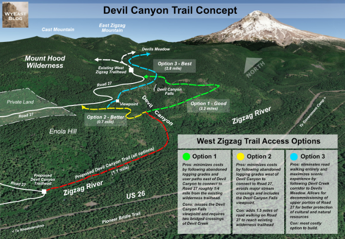
Clearly, these are some good options for a new trail, but which is best? The following concept map includes all three options – good, better and best – for a Devil Canyon Trail. All three options would begin as a new streamside trail that follows the Zigzag River to Devil Canyon, then turns upstream to follow Devils Creek a short distance to where the three options diverge (below):
[click here for a large, printable map in a new window]
A new streamside trail along the Zigzag River and Devils Creek would, alone, be a win for Mount Hood, where there are few such trails, thanks to the concentration of roads that follow many of the stream corridors around the mountain. Simply walking this 1.1 mile streamside segment would be a destination in its own right for hikers with young families or cabin owners looking for a short outing – and provide a way for those who don’t own summer cabins to enjoy the beauty of the Zigzag River, up close.
Hundreds of private cabins built on leased Forest Service land has made the Zigzag River mostly a privileged sight. The proposed options for bypassing the Road 27 closure would all include nearly a mile of trail along this beautiful stream, a destination in its own right
From the split in Devil Canyon, the first option — the old Tripod Trail on the east side of Devil Canyon – would be the easiest to build. The upper section still showed signs of regular use on our visit just a few years ago, and the old road grades are clearly still in place on the bluff face. It could be a straightforward way to formalize a new trail connection that simply follows an existing, already graded route. This might also be the most pragmatic option, given the many challenges the Forest Service is facing in our current political moment.
The main drawback of the Tripod Trail route are two crossings of Devil Creek. It’s an often rowdy stream and a significant barrier in the wet season that would require footbridges to safely cross. Another drawback of this option is that it entirely misses the Enola Hill viewpoint, an important destination in its own right, and possibly the only full view of Devil Canyon Falls to be found.
Devil Creek flows loud and fast through its steep canyon. This view was captured on our June exploration, during heavy spring runoff.
The second trail option would follow the old Enola Hill logging grades revealed on LIDAR, heading west from where the three trail options split to climb the hill in a series of switchbacks. This option improves on the Tripod Trail by avoiding stream crossings entirely. The route eventually connects to Road 27 at a point just east of the private parcels, and provides access to the clifftop viewpoint of Devil Canyon Falls after a short road walk along Road 27.
The main drawback of the second option is the 1.8 of miles of road walking from where the route would join Road 27 to the existing wilderness trailheads. As road walks go, however, the section above the private inholdings is narrow and rustic, climbing through dense, mostly untouched forest. It’s a big step up from walking a more modern, gravel forest road through clearcuts. If the Forest Service were to close and decommission this section of Road 27, it could also be more formally converted into trail, with the Salmon Butte road-to-trail conversion as one recent example.
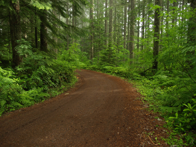
As road walks go, the public section of Road 27 is pleasant enough… but it’s still a road walk
It turns out the “trail” beyond the existing wilderness trailhead to Burnt Lake and East Zigzag Mountain is, in fact, a repurposed forest road that once led to a long-gone campground at Devils Meadow. Over the decades, the road has very gradually faded to seem more like a trail as nature reclaims its edges. Thus, if Road 27 were closed and simply designated as a trail, it would eventually fade to something more trail-like, even without a specific project to convert it to trail tread – albeit, over many decades.
The third – and preferred — option is to go big – to build a completely new trail that bypasses both the gated portion of Road 27 and the old, converted road section above the current South Burnt Lake trailhead. This new trail could be a far more scenic, rewarding route that follows dramatic clifftop views and parallels Devil Creek more closely on the approach to Devils Meadow.
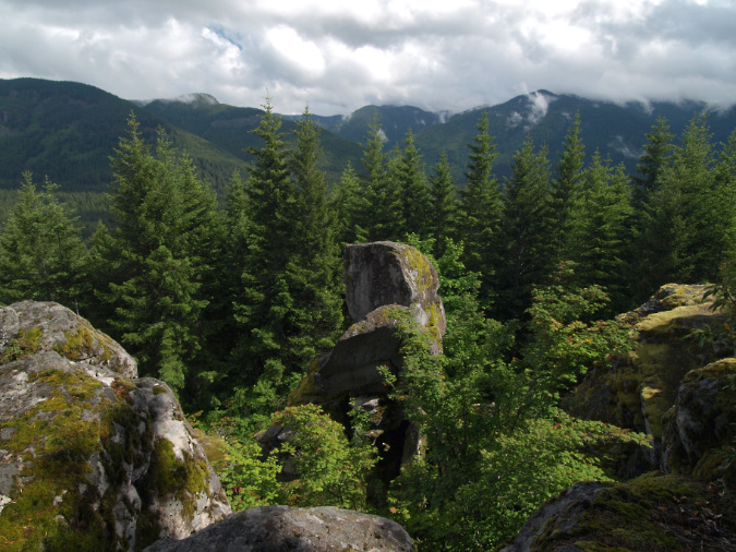
Looking south into the Salmon-Huckleberry Wilderness from the viewpoint on Enola Hill – a destination that would be part of both the second and third trail options described in this article
Such a trail would be similar to the Cold Springs Creek trail that passes Tamanawas Falls on the way to Elk Meadows, providing lots of turnaround points at meaningful destinations. This could provide options for folks of all abilities, will still providing backcountry access into the Mount Hood Wilderness for more adventurous hikers. The experience would also be similar to the North Burnt Lake Trail, on the opposite side of Zigzag Mountain, where the trail follows Lost Creek, passing a series of small waterfalls along the way to Burnt Lake.
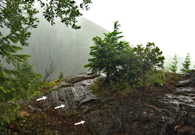
Look closely – assuming public access is restored — at the rocky viewpoint on Enola Hill and you can find ice-age glacial striations (see arrows in the image, above) from when massive glaciers filled the Zigzag River valley so deep they scraped and sculpted the tops of these cliffs more than 500 feet above the valley floor
The best part of this “go big” option would be the viewpoint on Enola Hill, itself – an important destination in its own right that deserves public access – but without the destructive behavior that roads too often bring to special places. I don’t claim much insight or understanding of the importance of this place to area tribes, though it’s my hope that a trail could be a benefit to the tribes by ending much of the destructive history that Road 27 has brought to the area, while once again restoring their access.
And the new trailhead?
All three trail options would begin at the base of Enola Hill, where Road 27 turns sharply and reverts to a dirt road as it begins its steep ascent. There’s plenty of space here for a turnaround, as there is an old road spur heading east (blocked by boulders).
The north Burnt Lake trailhead might be the best model for what could work at a new Devil Canyon trailhead. It has spaces for about a dozen vehicles and is operated as a Northwest Forest Pass site, providing some regulation on use and an official presence by the Forest Service.
This old spur from Road 27 at the base of Enola Hill would serve as the new Devil Canyon Trailhead.
Would improved access from the south side of Zigzag Mountain have the unintended effect of diverting trailhead use (and parking) from the popular north access to Burnt Lake to a new trailhead for the south access? Not likely. That’s because the hike to the lake from the north trailhead is only 3 miles long, with a few hundred feet elevation gain, whereas the new route to the lake from a Devil Canyon trailhead would be at least 6 miles long and gain well over a thousand feet in elevation to reach the lake.
So, what next?
As with any new trail, there’s opportunity for much of the work to be done in partnership with volunteer organizations, like Trailkeepers of Oregon (TKO) and other trail organizations. Local community groups in the Zigzag area could also be part of the effort.
A new trail here would need to be built in partnership with area tribes, as well, given their deep interest in Enola Hill. They would need to be consulted in all aspects of any project in order to respect and protect their cultural interests in the area, and hopefully there could be a way to provide both restored public access and protect these values.
Could this happen anytime soon? I’m hopeful the Forest Service is at least thinking along these lines. The Road 27 issue seems intractable, and it’s far too soon to give up on access to public trails that have been around for more than a century.
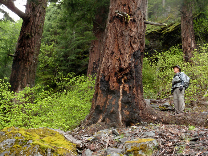
The burn scars on these giant Douglas fir in Devil Canyon date back more than a century to fires that swept most of Zigzag Mountain. This grove survived and is thriving high above Devil Canyon Falls
Yes, this is a tall order in a time of federal agency cuts and the current administration’s emphasis on extraction over all else on our federal lands. But we’re only a couple years from a new administration – and hopefully just a few months from restoring meaningful congressional checks on the administration that could help reverse some of the attacks on our public lands and dismantling of the agencies who administer them.
There’s also a lot of federal infrastructure funding for our national parks and forests that was authorized during the last administration, but is being slow-walked by the current one. These funds could be (and likely would be) obligated very quickly by a new administration, underscoring the importance of moving forward to plan for projects like this, even in these times.
After all, it’s never too early to plan for better days that do lie ahead!
__________________
Tom Kloster | May 2026
