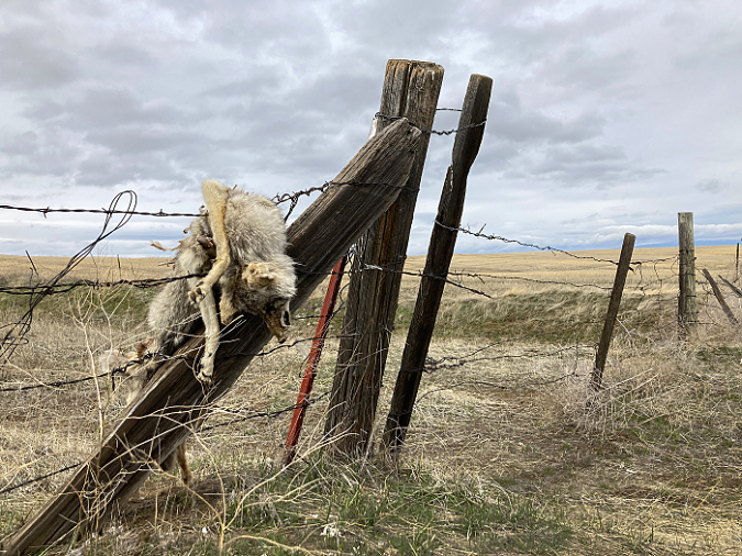
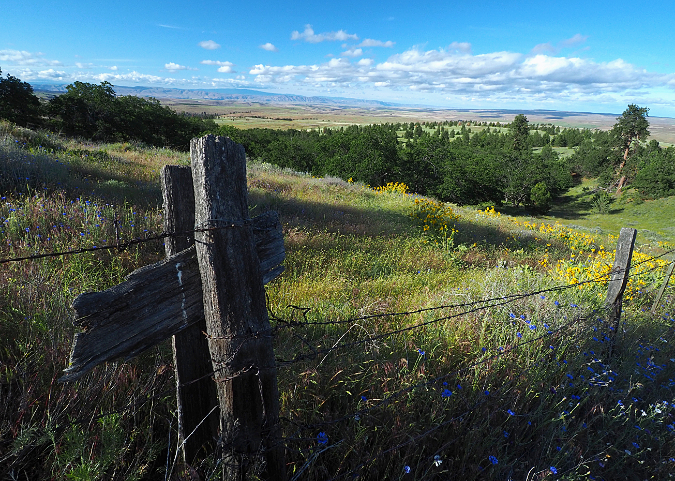
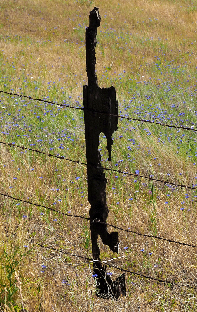
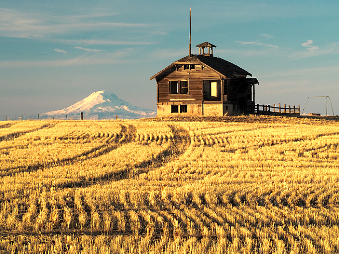
Killed coyote strung up on a fence along Center Ridge Road in Wasco County this winter
________________
Author’s note: I’ve gone back and forth on whether to include some difficult images in this article. I hope readers will understand why it’s important to see them once you’ve read the piece.
________________
As we reach the one-year mark of the COVID-19 pandemic that has turned our world upside down, I’ve been reflecting on how I spent much of my outdoor time over the past year in the desert country east of Mount Hood, where I could spend an entire day without seeing another soul. Along the way, I reconnected with some of my favorite spots, and found many more that were new to me. I was reminded why I fell in love with dry side of the mountains when I lived and worked there for seven magical summers during my youth.
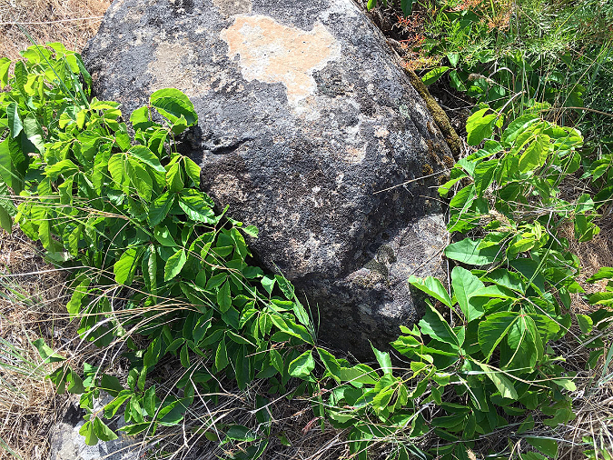
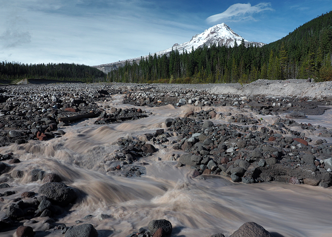
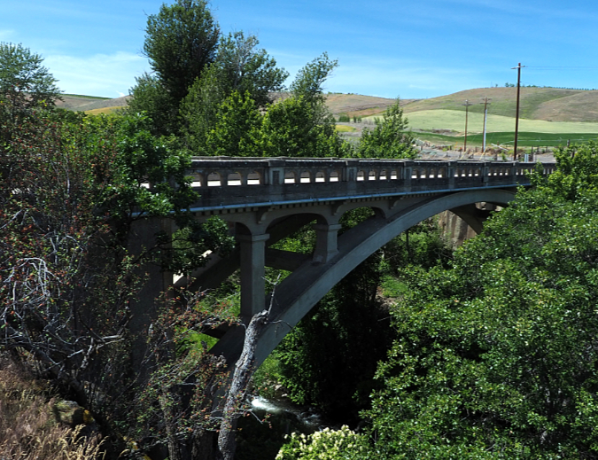
Over the past year of exploring the backroads east of the mountain, I also didn’t see a single killed coyote. Not one! This surprised me. It was once commonplace in sagebrush country to find their carcasses strung on barbed wire fences. Coyotes were vermin to old-school ranchers. Then, just last month, I ran across the familiar, grim scene captured at the top of this article. It was up on Center Ridge, in the rolling wheat country above the Columbia River. And yet, scenes like this that were once routine in ranch country have become rare these days. Why?
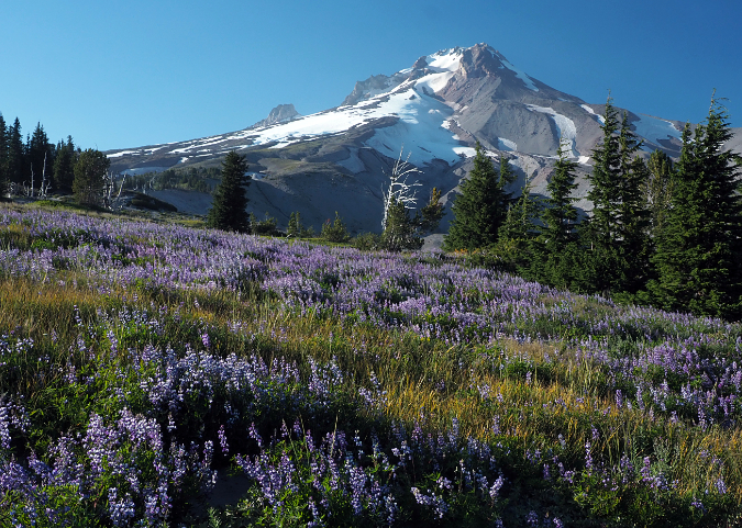
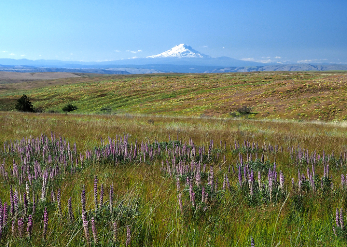
The rolling wheat fields on Center Ridge are prime habitat for coyotes (Dalles Mountain, Mount Adams and Mount Rainier are in the distance)
Perhaps because most ranchers today have advanced degrees in agriculture, their knowledge includes a formal science education that gives them an understanding of the benefits of living with predators, not exterminating them. They understand that top predators may be a nuisance to livestock, but they are also the ecological keystone that keeps the rest of the natural system in balance, which, in turn, is of even greater benefit to ranchers and farmers.
So, these days when I run across a shot, snared or poisoned coyote slung over a fence, there’s a pretty good chance that it’s the mark of an old timer — or simply someone who just doesn’t know any better. Old ways die hard. This used to be a standard practice based on the myth that the carcass would somehow cause other coyotes to shy away. That’s a tired idea borne of ignorance and unfounded hatred for the animals, nothing more.
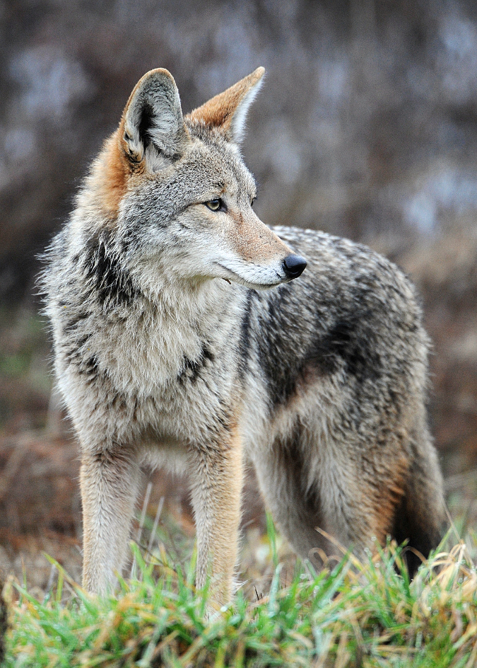
Today’s ranchers in Oregon are far more likely to appreciate the benefits coyotes bring to their bottom line, especially in the wheat country along the eastern Columbia River Gorge. Along with raptors, coyotes keep the rodent population (mostly rabbits, gophers, mice and voles) in check, keep grazing deer on the move and generally mind their own business as they cruise their very large territories. They also feed on snakes and sometimes carrion, as well as fruit and grass in season. Packs of coyotes may even take down young or infirm deer or antelope, though this is uncommon.
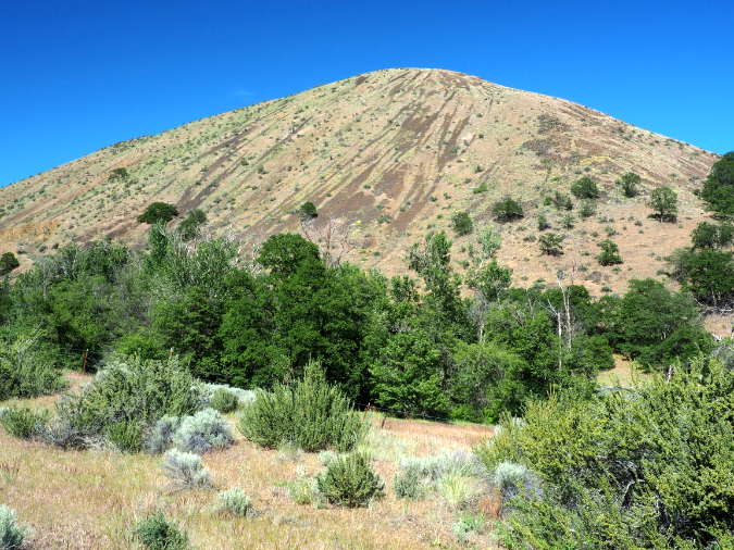
This remnant grassland view of Tygh Ridge is what much of the east side looked like before the arrival of settlement farming in the 1800s and it remains prime coyote habitat today
Coyotes often roam in organized packs, led by an alpha male and female pair that often mate for life, and that are the only breeding pair in the pack. The beta coyotes in the pack are non-breeding, and simply help hunt and feed the offspring of the alpha pair. Thus, killing an alpha male or female (or both) simply splits up the pack, opening the surviving animals to pair with lone males to create still more coyote families. For this reason, modern ranchers also understand that killing coyotes to remove them from the landscape can have exactly opposite the intended effect.
Despite over a century of systematic killing, coyotes are flourishing and expanding their territory, and now live in 49 states. This is partly because of the proliferation of new breeding packs from the extermination of alpha pairs, but mostly it’s because they’re very smart. Like the domesticated dogs that we spend billions on each year to pamper and celebrate as companions, coyotes are quick to observe every detail of human behavior and learn our ways. For wild coyotes, that means avoiding people – and our various means of exterminating them. That’s why seeing a coyote in the wild is a treat, and is typically fleeting.
Their ability to adapt has also allowed coyotes to move into urban areas, including Portland, where they have assumed top predator status. We spot them right here in my neighborhood in North Portland, where they roam the large natural areas and prey upon rats, opossum, raccoons and – especially – feral cats. While that last part might be hard for some to accept, the fact is, feral cats are a major problem in urban areas as predators of native birds. The arrival of coyotes is helping mitigate the impact of these non-native carnivore in our cities. It’s also true that coyotes can prey upon small pets in the city, a reminder to humans to keep our pets in enclosed areas and indoors at night.
This young coyote was killed and strung up by a rancher on Dalles Mountain Road a few years ago. This used to be a common sight in the ranch country of the eastern Columbia River Gorge
Coyotes have also responded to our simultaneous war on cougars and wolves that began in the 1700s, and continues to this day. Where wolves and cougars were once the apex species in many parts of the country, and preyed upon or hazed the smaller coyote, it is the coyote that has adapted and stepped into the void left by the disappearance of these larger predators. As cougars and wolves begin to rebound in a few areas in the country, they are reclaiming their top predator role, once again keeping coyotes in check. When wolves were reintroduced to Yellowstone National Park in the 1990s, the coyote population dropped by 40 percent!
Because of their size and potential threat to humans, wolves and cougars will likely always be less tolerated in our world. Though we’re just beginning to appreciate it, the role of coyotes as the substitute apex species in areas once roamed by wolves and cougars has helped keep natural systems in balance for all species – plant and animal.
Natural Survivors
Coyotes have an enormous range, with packs maintaining highly organized territories of anywhere from five to fifteen square miles – enough to cover multiple ranches, even in the sprawling wheat and sagebrush country east of Mount Hood. Like our domestic dogs, they have well-traveled routes, typically along ridgetops or along the edge of clearings where they can see the terrain and hunt for rodents. Mostly, they seek to avoid people in their rambles, which is understandable, given our history of hostility toward the species.
Coyote pups (Wikipedia)
In the wild, coyotes live short lives of just 5-10 years, though in captivity they can live up to 20 years. Adults in the wild typically weigh from 20 to 35 pounds, about the size of a Siberian Husky, though urban coyotes can reach as much as 45 pounds. Coyote alpha pairs can produce a litter of 2-12 pups annually, with pups reaching maturity in about 6 months. Coyote pups have a very high mortality rate of up to 90 percent, however, and only a few survive to adulthood. Some that survive will stay with their pack, others will roam and join other packs and a few males become lone coyotes, wandering on their own.
If you have the opportunity to see a coyote in the wild, you can’t help but be taken by how closely they resemble our domestic dogs, both in their appearance and behavior. They’re truly beautiful animals, and to watch them sprint upwards of 40 mph, it’s easy to see why native cultures celebrated both their intelligence and athleticism.
If you have the good fortune to hear a pack howling at night, it’s an especially memorable experience. No, they don’t represent a real threat to us, but it’s still quite humbling to hear them in the dark, knowing they are completely adapted to that environment and completely aware of us – even if we can’t see them. At night, we are in their realm.
Adult coyote hunting (Wikipedia)
The main threats to coyotes in the wild include some of the same canine diseases that threaten our domestic dogs, as well as lack of food and winter cold. In many parts of the country, humans continue to be a major threat with competitive “kill contests” still held to exterminate coyotes. In 2017, more than 11,000 coyotes were killed in Utah, alone, for $500,000 in bounties put up by state officials. Over 100,000 coyotes are still killed every year in the United States. Though these mass killings are gradually losing favor as science wins out over folklore, it’s still common for state wildlife agencies to promote methods for exterminating coyotes.
The good news is that ranchers and farmers are increasingly coming around to the benefits of co-existing with coyotes for all the good they bring to the land. This means changing their farming practices, especially during calving and lambing season in ranch country.
In Oregon, coyotes are classified as a non-game predator. What does that mean? It means that anyone can kill a coyote, with no limit or permit required. Thankfully, science is winning here, too. Wildlife agencies and agriculture science are evolving, promoting science-based best practices for farmers and ranchers to co-exist with coyotes. Oregon’s Department of Fish and Wildlife has replaced old-school instructions for coyote extermination on its website with new-school guidelines on how to co-exist. That’s real progress, though regulating coyote hunting will be a tougher political hurdle to clear.
Urban coyote in Lincoln Park, Chicago (Wikimedia)
The more worrisome trend is urbanites moving into farm and ranch country and bringing domestic cats and toy-breed dogs with them. These small pets make for easy prey for coyotes, especially when left to roam. Worse, people moving into ranch country often encourage coyotes to lose their fear of humans by leaving pet food outside and by not treating them as wild animals. Just as urbanities living in the country are a growing nuisance to farmers with their complaints about dust, noise and pesticides that come with farming, these folks may also emerge to be a new threat to coyotes, too, simply by encouraging them to lose their fear of us.
Despite these threats, and our long war against them, coyotes continue to adapt and thrive. Scientists now recognize 19 subspecies of coyote, including urban species that are now common in city parks and preserves across the country. Coyotes have observed us and figured us out, and they are here to stay. Their ability to adapt bodes well for the species, and for the ecosystems that increasingly depend on them as top predators, too.
Epilogue… and Prologue?
Over the winter, I was coming down a gravel road from Center Ridge into a narrow Easton Canyon, just south of The Dalles. I stopped to take a photo of Mount Hood when I spotted a group of Mule deer perfectly silhouetted against the last glow of sunset. I watched this lovely scene unfold for quite a while, until the deer had moved on and stars suddenly began to fill the night sky.
Mule deer silhouetted against Mount Hood in the Center Ridge area of Wasco County
As I was quietly packing up my camera gear in the dark, I was startled by a sudden series of loud, quick yips right behind me! A coyote was in the sagebrush directly above the road, somewhere along the canyon wall. Soon, more yips began to echo from across the canyon, first below me, then from across the canyon, then further up the canyon. The chorus grew until some of the yips turned to howls, then went silent, as quickly as they had started.
It was an eerie experience that made my hair stand on end. I’d heard coyotes many times before, but I had never been in the middle of a pack. Though I knew I wasn’t in danger, the moment still triggered a primal reaction – these were wild predators, after all. I hoofed it back to the car, quickly loaded up my gear and gave thanks for a truly memorable encounter.
So, when I came across that coyote carcass a few weeks ago, senselessly killed and strung up on a barbed wire fence, I couldn’t help but appreciate what was left of this once-beautiful, brilliant animal. Much of its handsome coat was still intact and moving in the breeze, its ears still pointed and perfect. Were it not mangled, ribs protruding, I might have thought it somehow alive.
A sad, senseless practice fading with time, a grim reminder of our ignorance and folly in attempting to control the natural world around us
The sight of this animal brought back that nighttime chorus under the stars from just a few weeks before, just a couple of miles from this spot. Had this unlucky coyote been among those that I heard that night? Quite possibly. It also gave me a deeper appreciation for the resiliency and balance of nature all around us, despite our relentless efforts to upset it. The coyotes are adapting and winning. Thankfully.
As a broader society, we’re slowly changing our thinking about predators, too. We’re getting better at observing and understanding them and beginning to accept their presence – especially coyotes. We seem to be on a path of learning to simply avoid coyotes just as they avoid us, ensuring that they remain truly wild. We’re learning to co-exist.
As I write this annual year-end post after a calamitous 2020, the world seems just a bit more hopeful. The presidential election will shift public lands policy 180 degrees back toward conservation and restoration, and with the release of two COVID-19 vaccines, the end of the world pandemic is finally on the horizon.
And so, I share some of the stories behind this year’s Mount Hood National Park Campaign scenic calendar with a cautious spring in my step (or my fingers as they type this sentence, at least). You can pick up a copy of the calendar here for $29.95:
As always, all proceeds will go to Trailkeepers of Oregon (TKO) to support their ongoing effort to care for trails as gateways to our public lands. Zazzle prints these calendars with exceptionally high quality, and they also have large enough boxes to be quite functional for tracking important dates and your trail plans. They make nice gifts, too, of course!
Over the years, I’ve described the Mount Hood National Park Campaign as “an idea campaign” with the simple goal of keeping alive the promise of better protections and restoring the grandeur Mount Hood and the Gorge. I started the project in 2004 as a way to continually remind Oregonians and Washingtonians living in WyEast Country that national park protection was proposed at least three times in Congress, in the 1890s, 1920s and the 1930s. Each time, logging and other extraction industries (and later, the emerging ski industry) were the chief opponents — along with the Forest Service, itself.
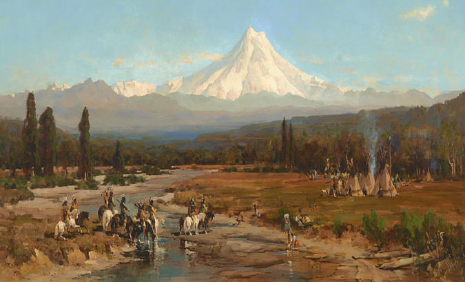
Thomas Cole painted this idyllic scene of Native American life in WyEast Country in the 1870s. The mountain continues to be beacon of inspiration and awe for people living in its shadow to this day
If you’ve watched Ken Burns’ magnificent National Parks series, you know that every park was a battle, typically between short-term exploitation interests and progressives looking toward posterity for future generations. There were no easy wins.
And, so it will be for Mount Hood and the Gorge until enough locals (or our children and grandchildren) recognize national park protection as both urgent and deserving for these world-class places. We haven’t treated them too well over the past 150 years, but real change is suddenly afoot in 2020. What? Yes, you read that correctly… and I will share more about that exciting news in future blog posts!
This beautiful cove at the foot of Crown Point was called “Echo Bay” when it was still connected to the Columbia River in this 1870s photo. This was among the spots that inspired the first Congressional effort to create a national park here
But until then, this article is a tour of some of the places that make WyEast country special, and are featured in the 2021 MHNP Campaign scenic calendar. As always, every image in the new calendar was captured over the past year and, as in past years, there are some lesser-known places mixed in with some of the more familiar.
The 2021 Calendar Images
Salmon River in late Autumn
The cover image for the 2021 calendar comes from a very familiar spot along the Old Salmon River Trail, near the community of Zigzag. This quiet trail was bypassed — and spared — when the Salmon River Road was built in the post-World War II logging boom. Today it offers one of the most accessible trails into ancient rainforest anywhere in the Pacific Northwest. This photo was taken just a few weeks ago, too. Because of its low elevation, it’s a trail you can hike year-round. Here’s the Oregon Hikers Field Guide description of the trail.
For January, I chose an image captured from above the West Fork Hood River Valley, on Butcher Knife Ridge. In this scene, Mount Hood is emerging from the clouds after the first big winter storm of fall. I’ll be posting more articles in 2021 about the West Fork valley, as there is some very exciting news to share about this area.
Mount Hood’s rugged northwest face in early winter as viewed from Butcher Knife Ridge
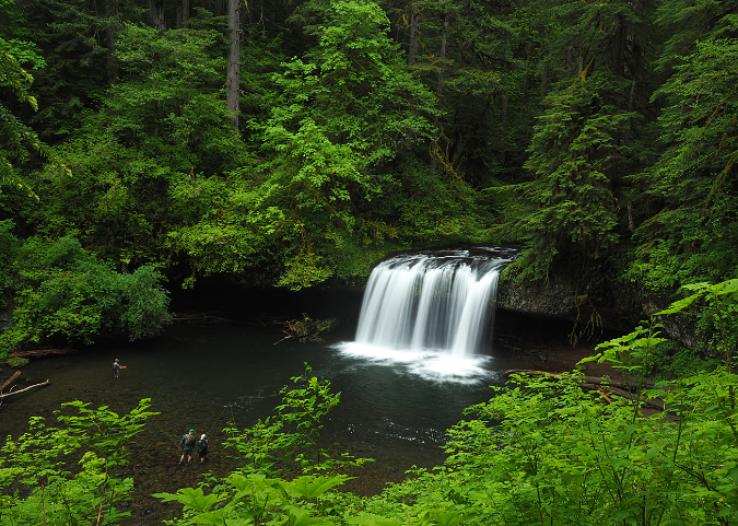
The February image is a familiar view of Wahclella Falls on Tanner Creek, one of the premier trails in the Columbia River Gorge. Before the 2017 Eagle Creek Fire, I visited this trail several times each year, as it’s not only a personal favorite, but also a trail that makes for a great introduction to the Gorge for new hikers or visiting family.
Wahclella Falls on Tanner Creek
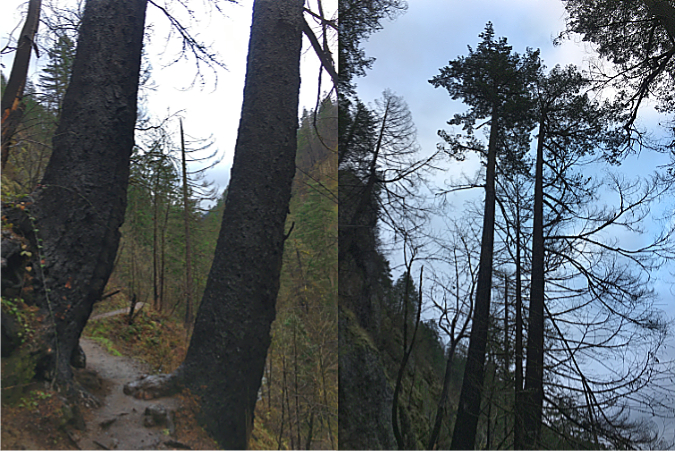
The image in the new calendar is from a visit last winter, and it was my first since the fire. Though the fire did burn through the lower Tanner Creek canyon, many trees survived, especially around Wahclella Falls. Notably, a pair of big trees familiar to hikers also survived — the twin Douglas firs flanking the lower trail (below). As of this year, their upper canopies are still green more than two years after the fire, and that bodes well for them to survive for many years to come.
The familiar twin Douglas firs along the Wahclella Falls Trail have survived the 2017 Gorge fire… so far
What I couldn’t have guessed is that the COVID-19 pandemic restrictions kicked in just a couple weeks after my visit, and Wahclella Falls was once again closed to the public.
As hard as these Gorge trail closures have been for hikers, there are a couple of silver linings. First, they have allowed trail volunteers from TKO, the Pacific Crest Trail Association (PCTA) and other volunteer trail organization to continue the hard work of restoring trails damaged by fire without having to accommodate hiker traffic. Perhaps more importantly, the closures have also allowed forest recovery to begin within the pressures that heavy visitation on popular Gorge trails brings.
Lower White River Falls in spring
The March image (above) features Lower White River Falls, a lesser-known cascade downstream from the main falls at White River Falls State Park. Where the main falls is a raucous spectacle, the lower falls is quiet waterfall in a secluded canyon, where it is framed by desert wildflowers in late spring.
Poison likes to grow in the shade of boulders along the White River — watch where you sit!
The user path to the lower falls has become increasingly prominent in recent years as more visitors discover this pretty spot (and its excellent swimming hole), but be forewarned, the path is lined with Poison Ivy. This relative of Poison Oak bears a close resemblance, but grows as a ground low ground cover in the sandy floodplain along the river, often in the shelter of boulders and old logs.
Lower White River Falls
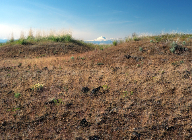
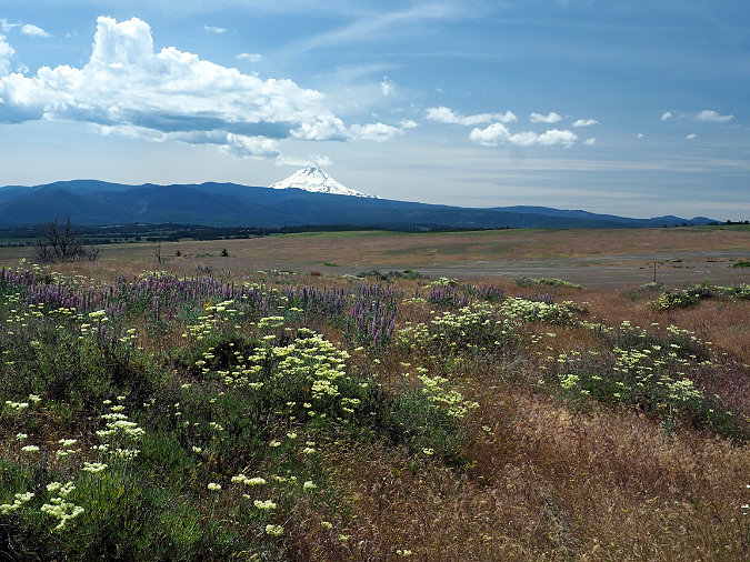
For April, I selected another scene from Mount Hood’s rain shadow, a wildflower meadow on the edge of the tree line where forests give way to the desert country east of the Cascades. This bucolic scene looks across the rolling wheat country of Wasco County, toward the Columbia Hills and the Columbia River, on the horizon (below).
Wildflower meadows on the east slope of the Cascades near Friend
Though you wouldn’t know from this photo, the South Valley Fire swept through this area in 2018, one of three major range fires that combined that year to burn nearly 200,000 acres. Two years later, and only the scattered snags of Ponderosa pine, Western juniper and burned fence posts hint at the fire, as the sage and grass savannah has recovered in a remarkably short time. But the fires had a human toll, too. Homes and barns were burned, as well as several historic farmsteads that can never be replaced.
Only a few charred remains tell the story of the 2018 range fires east of Mount Hood
Switching back to the west side of the Cascades, I chose a scene from a visit to Silver Falls State Park for the May image. With many of the Gorge waterfall trails still closed by the aftermath of the Eagle Creek Fire, Silver Falls visitation has exploded over the past couple years, as hikers look for new places to get their waterfall fix.
Visiting Silver Falls State Park is pretty close to a national park experience, as the park is loaded with 1930s Civilian Conservation Corp construction and the Oregon Parks and Recreation Department do an excellent job maintaining and curating the park’s network of scenic trails. Lower South Falls (below, and the May image in the new calendar) and nearby Middle North Falls are favorites among photographers in the park, and they have some similarities. Both begin as a wide curtain of falling water before crashing onto the rocky basalt aprons that make up their base, and both have a trail behind them.
Lower South Falls on Silver Creek
A few years ago, a local Republican legislator introduced a bill proposing National Monument status for Silver Creek. The bill didn’t go anywhere, but it was a nice opportunity to showcase the area and a reminder that seeking national park status can be a bipartisan effort, even in these days of deep political division.
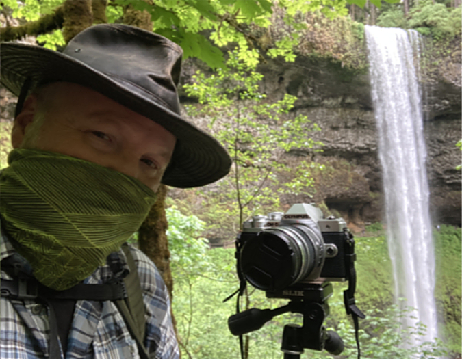
Pandemic-compliant blogger at Silver Creek State Park
Visiting Silver Falls State Park (and most other state parks) in 2020 also meant controlling the COVID-19 virus while huffing and puffing on a buy trail. While I was discouraged by the disregard for masks on my trips to Silver Falls last spring (maybe 1 in 5 had one), there has been a noticeable uptick in mask use in our state parks national forests since. That’s good, because in a year of pandemic shutdowns and closures, the benefits of being outdoors and connecting with nature have never been greater.
Crowds of pandemic-defying hikers at Silver Falls State Park on Memorial Day 2020
For June, I chose a scene from just off the Timberline Trail, along the rim of the White River Canyon (below). This expansive Lupine meadow is only a few steps from the trail, but just out of view and thus known to surprisingly few.
Summer Lupine meadows along the rim of White River canyon
If only this blog had a virtual scratch-and-sniff, as there is nothing quite as heady as the sweetly-scented mountain air in a Lupine meadow, and this one was no exception. For those who haven’t had the experience, Lupine are in the pea family, and have the same sweet aroma as garden sweet peas — but with a mountain backdrop!
For July, I chose another wildflower scene, though this one fits more of a rock garden motif, featuring yellow Buckwheat and purple Penstemmon among the chunks of andesite scattered here. This is the historic Cooper Spur shelter, just off the Timberline Trail on the mountain’s north side. Cooper Spur, proper, rises to the left and the Eliot Glacier tumbles down Mount Hood’s north face to the right of the shelter. This is one of several stone shelters built by the Civilian Conservation Corps in the early 1930s and today is one of just three that still survive (the other survivors are at McNeil Point and Cairn Basin).
Cooper Spur Shelter in summer
Follow the climbers trail to the right of the shelter to the nearby moraine viewpoint (marked by large cairn) and you’ll have a front-row view of the Eliot Glacier. While I was there, a house-sized ice blocks suddenly collapsed (below), filling the canyon with a roar! It’s always a thrill to see and hear our glaciers in action.
Icefall collapse on the Eliot Glacier!
Another mountain scene fills out the summer as the August image in the new calendar. This multi-image composite assembles the impossibly massive scene at the western base of the mountain, where the Timberline Trail fords the twin branches of the Muddy Fork (below). From here, the mountain rises more than 7,000 vertical feet above the scene, and dramatic waterfalls tumble down the 800-foot cliffs that frame the canyon.
The wide-open scenery of the Muddy Fork canyon
The Muddy Fork valley is a volatile, continually changing landscape. In the early 2000s, a massive debris flow swept through, felling an entire forest and leaving a 25-foot layer of rock and sand on the valley floor. The Muddy Fork has since carved through the debris, all the way down to the former valley floor, revealing the stumps of trees that were snapped off by the event. Some are visible along the stream at the center the above photo. Meanwhile, the rest of the Muddy Fork debris flow is already dense with Red Alder, Cottonwood and Douglas Fir pioneers that are quickly re-establishing the forest, continuing the eternal cycle of forest renewal.
Several photos in this year’s calendar are from the dry country east of Mount Hood, in the rain shadow of the Cascade Range. I made several trips there while researching the strange desert mounds unique to the area (see “Mystery of the Desert Mounds“) and I fell back in love with the landscape, having spent time living there in the early 1980s. The September image in the new calendar is of a lesser-known gem in this area, the historic Nansene Community Hall (below) located on the northern slopes of Tygh Ridge.
Remains of the historic Nansene Community Hall on Tygh Ridge
The community hall dates back to the early 1900s, when sheep ranching was still the dominant industry in the area. Sprawling wheat fields and cattle have long since replaced the sheep herds, but thanks to the arid climate, abandoned wood structures from the early white settlement era can survive intact for a century or more. But they can’t survive fire, and while many historic homestead structures were destroyed by the 2018 range fires that swept through the area, Nansene Hall was among those spared.
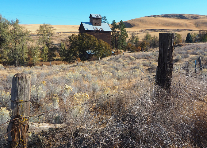
Thankfully, the iconic grain elevator at Boyd survived the fire, too, and this photo (below) was a candidate for the calendar, save for the fact that Mount Hood isn’t peeking over the horizon!
Grain elevator on Fifteenmile Creek at Boyd
Several historic schoolhouses in the area also survived the fire, including the picturesque Center Ridge Schoolhouse (below), located a couple miles northeast of the Nansene Commumity Hall. This amazingly intact old building was designed with more aesthetics in mind than you might guess. The big windows along the west side of the structure define its single classroom, but the building was sited at an angle to ensure that Mount Hood filled the horizon through those windows, while Mount Adams looms to the north of its playground!
Center Ridge Schoolhouse and Mount Adams
While exploring the Tygh Ridge area this year, I happened upon a toxic creature that was unknown to me: the Green Blister Beetle (below), part of the legendary family of bugs that Spanish Fly is derived from. This iridescent native of the western states is highly toxic to the touch, though I only learned that later, when I was trying to identify this bug from photos I had taken while surrounded by a swarm of them in the field!
Don’t touch the Green Blister Beetle! (though the smaller beetles in this photo don’t seem to be bothered by their toxic neighbor)
Fortunately, I did not handle them, as that can lead to a potentially dangerous reaction. So, while we don’t have many toxic plants and creatures to navigate in the Pacific Northwest, here’s a new one for the list of those to avoid.
The Blister Beetle confab was unfolding in the historic Kingsley Catholic Cemetery, one of the more photogenic spots in the Tygh Ridge area. While walking among the pioneer graves that day last June, I also spotted this wonderful note hanging from a tree, a most welcome bit of hope and optimism in an otherwise grim pandemic year:
Sometimes a simple note can make a tough year a little better…
I later shared the note with a friend in the Dufur area, who in turn shared it in local circles there, hopefully drawing some interest. Little discoveries like this are poignant reminders that the future is always bright through young eyes, and it’s our job as elders to embrace their optimism and sense of promise.
For October, I selected a scene familiar to many (below). This is the view from just below the Vista Ridge trailhead, where the mountain suddenly unfolds for arriving hikers. It’s a popular roadside spot for evening photography, especially in fall when Vine Maple light up the scene.
The popular photographers’ tableau at Vista Ridge
However… when I stopped there this fall, I was quite annoyed to see that Forest Service contractors hired to brush out the road had dumped their slash right in the middle of this lovely talus slope! Sacrilege! So, I took a deep breath, put on a pair of gloves and spent a couple hours dragging the slash down the road to another debris pile that was out of view in a nearby wooded area.
Aargh!
Sacrilegious!
Why get my dander up over this? Because talus slopes are special. They’re scenic and offer welcome views in our heavily forested region, of course. But they’re also home to species that depend on these unique places to survive. The best known are the tiny Pika who live exclusively in talus fields, but they are just part of the unique web of plants and animals found in these rocky islands. They deserve to be revered as unique places in the same way that our understanding of deserts has evolved in recent years to see them as places full of life, despite their lack of trees.
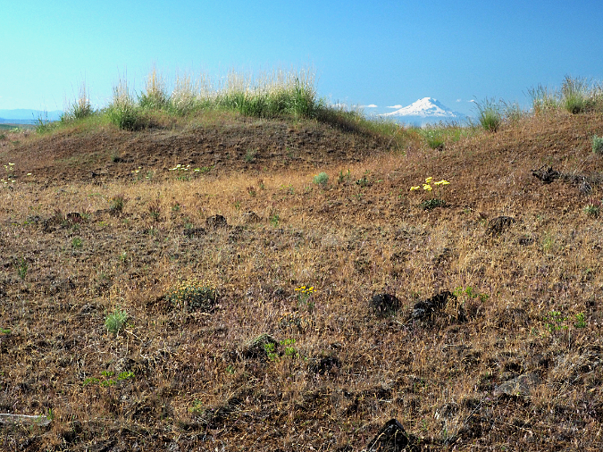
For November, I went back to yet another image from the slopes of Tygh Ridge (below). This is a view looking north across the broad, gentle apron of the ridge toward Mount Adams, shining on the far horizon. Less obvious in this autumn view are the many fallow fields where wheat was once planted, but now are carpeted with wildflowers and native grasses. What gives?
Tygh Ridge Locust trees frame Mount Adams
This photo (below) from a nearby spot was taken in June, and shows the expansive meadows that now cover formerly plowed land on Tygh Ridge. It turns out that these areas have been allowed to recover with native grassland species to benefit wildlife as part of the federal Conservation Reserve Program. It’s an opt-in program that compensates farmers for making long-term commitments (typically 10 or 15 years) to leave fields fallow for wildlife recovery. Hundreds of acres on Tygh Ridge are now part of this program.
Lupine meadows on Tygh Ridge are part of the Conservation Reserve Program that compensates famers for allowing fields to revert to natural cover to benefit wildlife
Heading back to the west side for December, I chose another image from beautiful Silver Falls State Park, though not of one of the iconic waterfalls. Instead, this scene (below) captures a classic winter rainforest scene, with the bare, contorted limbs of moss-draped Bigleaf maple revealed, now that their summer jacket of leaves has been discarded for the winter.
North Fork Silver Creek in winter
With all of the tragedy and trauma that 2020 brought to the world, this simple scene seemed most appropriate for closing out the calendar for the coming year: calming, cool and reflective, and with a needed sense of order and eternity that a misty day in the rainforest can bring us.
Remembering 2020..?
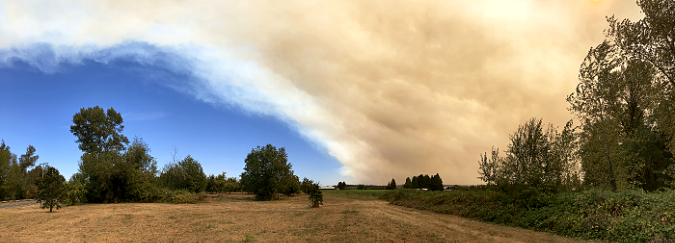
Riverside Fire exploding into a conflagration in September
Assembling this year’s calendar was yet another reminder of the horrendous year we are leaving behind. While spending time in the outdoors is always a needed escape, in 2020 we suddenly found many of our favorite forest sanctuaries closed by COVID-19. Later, the massive Riverside and Beachie fires roared through the Clackamas and Mount Jefferson areas, perhaps closing them for years to come, and with little known about the full impact of these fires at this time.
As I sorted through about 130 images that I’d set aside over the year, everything fell into two categories: burned in the fires or not. We still don’t know just how extensively the Riverside Fire burned the Molalla River watershed, for example, though we do know that it reached all the way to the Willamette Valley, causing evacuations in several communities on the valley floor — an unthinkable development in our recent history with fire. The Molalla River corridor remains closed, and it could be years before the Bureau of Land Management reopens the area to the public.
The Molalla Eye… before the fire
Some spots were spared, if just barely. Just south of the Molalla corridor, the Riverside and Beachie fires converged and bolted Silver Falls State Park. The park was spared, but not nearby Shellburg Falls, which was intensely burned, with no surviving forest. The Little North Fork valley was equally charred, including historic structures at Opal Creek.
Upper Butte Creek Falls… spared by the fire
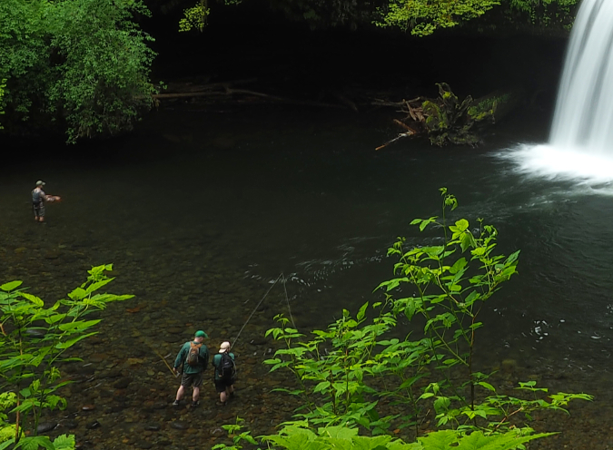
Meanwhile, the fires followed ridgetops above Abiqua and Butte Creeks, but left the waterfalls and big trees there intact. Butte Creek was on my mind, as I had just made a trip there last June, when I ran into a family learning to fly fish at Upper Butte Creek Falls. While this spot didn’t burn, it will still likely be affected by the fires. As we’ve learned following the 2017 Eagle Creek Fire in the Gorge, stream corridors spared by the actual fire will soon fill with logs downed by the burn, and this will likely be the case in places like Butte Creek in coming years.
Fishing at Butte Creek
I’ve posted many articles about fire, and our need to come to terms with both its inevitability and benefits. And while it was frustrating to learn that the Riverside Fire was — once again — human-caused, it’s also the case that the forest will recover. With that recovery comes opportunities to rethink how we manage the Clackamas River watershed, and I’ll be posting more on that topic in the coming year. If catastrophic fires are a reset for the forest, then they can also be a reset for how we manage them.
While the wildfires took center stage in Oregon in September, the COVID-19 crisis is the tragedy that will forever mark 2020. Like many, social distancing took me outdoors, but I quickly found that my usual haunts were packed with people, and too many were without masks or observing basic precautions for preventing transmission of the virus.
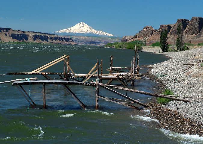
So, I ventured a bit farther afield in WyEast country, visiting several places for the very first time, but also taking great pains not to interact with others and risk accidentally being a spreader, myself. Once such place was Cliffs Park, a remarkable spot along the Columbia River that offers a stunning view of the Columbia River. On a quiet Sunday, I had the place to myself, but the empty fishing platforms were a reminder that indigenous peoples have been fishing these beaches for millennia — and that in our pandemic, Native Americans have been among the hardest hit by the virus.
Tribal fishing platforms at Cliffs Park
Cliffs Park
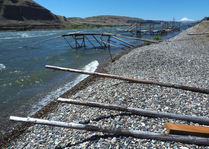
Looking downstream at Cliffs Park, WyEast rises above the basalt walls of the Gorge, and the scene seems timeless. Turn around and look upstream, and the John Day Dam fills the horizon, another reminder of the cultural devastation that white settlement brought to the indigenous societies that had flourished along the river for millennia — and the trauma they still carry from the loss of Celilo Falls, just downstream from Cliffs Park, and inundated by The Dalles Dam in 1957. This recent piece in Portland Monthly on the subject is well worth reading:
It’s fairly easy to be socially distant (and completely alone) in the wide-open desert country east of Mount Hood, but what about some pandemic solitude on the mountain? It turns out to be in plain sight, if you’re willing to do some boulder-hopping. Over the summer, I made several cross-country forays into the White River flood zone, and to my surprise, the river channel abruptly changed sometime in late summer, before my final visit in late September.
The White River strikes back… again!
My guess is that a cloudburst or just some steady rain had kicked off a debris slide far up the canyon, but the volume was such that the entire floodplain was affected, with a couple feet of new sand and cobbles left behind by the flood. On my visit, the river was still trying to find its new course, and made a wonderful clattering noise it rocks and pebbles rolled down the stream in the muddy water.
The White River finding its new path
It’s not the first time the White River has changed course, that’s for sure, and it certainly won’t be the last. Seeing the raw forces of nature steadily at work was also quite reassuring. Yes, humanity has been struggling with a pandemic this year, but the mountain didn’t even notice. Nature has a way of putting our human frailty in helpful perspective, and reminding us that we’re temporary features here.
And, on a personal note…
Everyone has their list of reasons to hate 2020, and I certainly have mine. I’ll start with an odd one that connects some dots, and it’s about my photography. After decades of making some of the most innovative, compact cameras that seemed to be designed with hikers and active photographers in mind, Olympus announced last June that it would be selling off its camera division. What..??
It turns out that like all traditional camera makers, Olympus had seen sales sag with the explosion of smartphone and their amazingly good photo capability. No surprise, there, and I’m no exception. I marvel at what my iPhone can do. But I’ve also been a loyal Olympus user since I was 18 years old.
End of an era for this photographer? Not a chance! My newest Olympus (complete with collapsing 14-45mm zoom lens) sitting in the palm of my hand…
The good news is that the buyer of the Olympus line is planning to continue offering a full lineup under the old brand name, so we’ll see how that goes. But in the meantime, I used this troubling news as rationale to double down and pick up a few lenses and another camera body that will help me keep this blog full of photos for years to come!
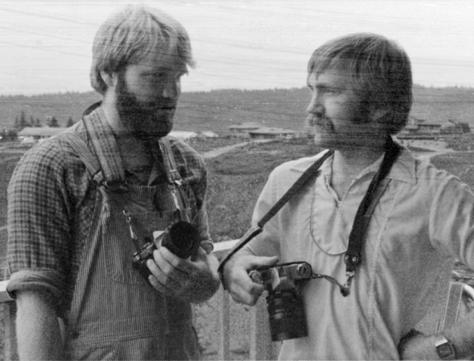
Here’s where I will connect some dots, as the Olympus news had deeper significance with me, as I got the photography bug from my oldest brother Pete, who died in 2017. Pete is on my mind whenever I’m out in the forest or up in the mountains shooting with my beloved Olympus cameras. He helped me pick out my first Olympus camera when I was a teenager.
Me (left) as a 20-year old with my late brother Pete and my first Olympus way back in 1982. Pete was my photography inspiration and my mentor
Pete and I had a special connection that went beyond photography, and I’m thankful for the time I had with him, but I’m especially thankful for the time I still have to be out exploring the world. I’d wish he could still join me, and after losing him, I’ll surely never take my time on this earth for granted again.
This regrettable year also marked the passing of my dad on September 1. He was 91 years old, and like my brother Pete, had a huge impact on my life. Dad moved our family out here from Iowa in 1962, just few weeks before I was added as the last of five kids (and the only one born in Oregon). Dad was drawn to the Pacific Northwest by the active outdoor life, and passed that appreciation on to his kids — and to my mom, who passed away in September 2018. Together, they climbed mountains, backpacked, camped, fished and when it came time to retire, lived out their years on a forested hilltop.
My folks enjoying a pitcher and pizza just three years ago, in September 2017. These transplanted Iowans gave me my love of the Pacific Northwest outdoors
Needless to say, my life moving forward has changed forever with the loss of both parents and my oldest brother. But if every kid wants to make their family proud, I felt good when it came time to sort through the things my folks left behind. Their home was full of photographs, sketches and sculptures that I’d made for them over the years, and they had even saved every Mount Hood calendar I’d printed since starting these in 2004!
So, I know they were pleased that they had successfully planted that outdoor life and conservation ethic in me, and whatever I can do as a conservationist and advocate in my remaining life, it will be an extension of their influence — and Pete’s, too. I’ll always miss them, but whenever I’m in the outdoors, I’m really still with them!
Their passing is also a reminder to me (and all of us) that an essential part of being a conservationist and steward for our public lands is to pass along that ethic and passion to those who will follow us, a role that is now even more prominent in my own mind.
Looking forward to 2021!
What’s coming in 2021 for this blog? As always, I have lots of articles underway, and as I mentioned at the top, the potential for some very big news for the mountain. I will post on that topic as soon as I learn more. I also hope to see some of the Riverside Fire aftermath first-hand and report on what the Clackamas watershed looks like today, along with ongoing visits to some lesser-known spots in WyEast country.
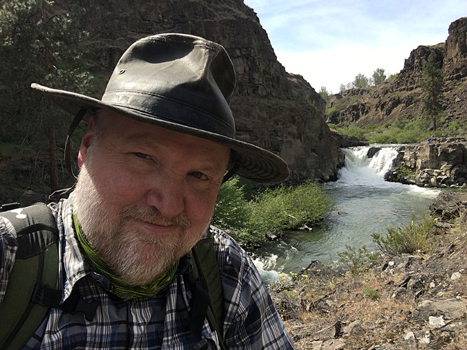
The author at Lower White River Falls in June (with mask in stored position!)
Most of all, a return to life beyond the pandemic is on all of our minds, perhaps as soon as next summer. Until then, thanks for reading the blog and for indulging me in these annual reflections. Best to you in 2021, and I hope to see you on the trail, sometime!
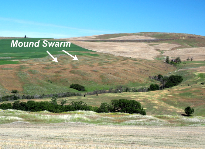
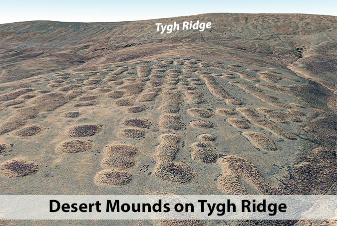
Mount Adams framed by mysterious desert mounds found east of Mount Hood
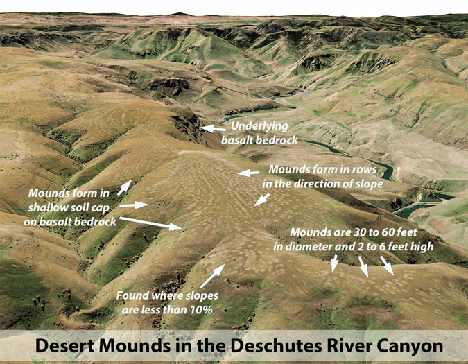
A strange phenomenon plays out in the shadow of Mount Hood, across the broad desert ridges and plateaus of the Columbia Basin. Tens of thousands of dome-shaped soil mounds that range from a dozen feet to more than 60 feet in diameter rise atop the rocky bedrock, often in swarms that number in the hundreds.
These mounds were given the unfortunate name of “biscuit scablands” by white emigrants arriving in the Northwest in the mid-1800s. They understandably loathed them as yet another miserable obstacle for wagon travel, no doubt having to weave among them on the rocky ground that typically surrounds these mounds.
Later, they discovered that farming the “scablands” was equally difficult, and even today the sweeping wheat fields of the Columbia basin are still plowed around many of these odd formations where the ground has never been tamed.
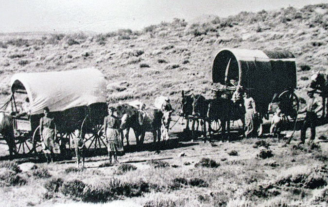
White settlers arriving by wagon in the Columbia Basin in the 1800s gave “biscuit scablands” their name as they navigated thousands of these mounds along their journey (Oregon Trail Center)
Their pioneer name refers to “biscuits” of mounded soil on the scoured, rocky basalt substrate, or “scabland”, that typically surrounds the mounds. These mysterious humps in the desert are usually round, but depending on slight variations in slope, they also appear in oval and oblong shapes.
A maze of desert mounds once covered a much larger part of the Columbia Basin, but more than a century of farming has erased many of the “biscuit” fields from the landscape. Still, even after 150 years of farming, they can still be found in the thousands, and their origin is still debated by geoscientists.
What are they?
Many theories on the formation of these mounds have been put forth since white settlement in the Pacific Northwest began. Among the early theories were Indian burial mounds, giant anthills, gopher mounds, wind-blown dunes, bison wallows and (of course!) extraterrestrials. While creative, none of these explanations are supported by field observation.
Similar mounds are found around the world, and often called “mima mounds” after the famous Mima Mounds near Olympia Washington. Recently, the early theory that they were created by pocket gophers has found favor again.
While it sounds far-fetched, the gopher theory was boosted in the 1980s when a scientist used metal tracing to show that pocket gophers living in soil mounds in California actually pushed soil toward the top, and not outward, as was expected. This gave new life to the idea that gophers could create massive mounds over time.
Did pocket gophers create the desert mounds east of Mount Hood? Field science still says otherwise…
Scientists hoping to build on this discovery have since created a computer model to show that, over millennia, generations of pocket gophers could create large mounds on this scale.
While the renewed gopher theory might hold true for soil mounds found elsewhere in the world, the desert mounds found east of Mound Hood are different. The mounds of the Columbia Plateau are highly organized in their shape and distribution in a way that can’t be explained by the gopher model. These mounds clearly formed in direct relationship to the slopes they have formed upon, something that scientists have yet to explain with gopher models.
There’s also the fact that computer simulations of gopher activity are only as valid as the model inputs used by the scientists, especially when the simulations involve thousands of iterations, as the gopher model does. The gold standard in science is still direct field observation, and only the magnetic tracing research from the 1980s supports the gopher theory with this rigor.
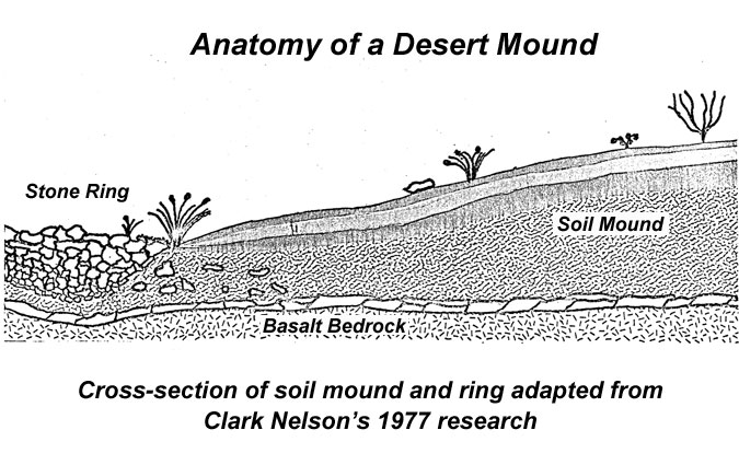
So, for this article I’ve turned to original field research completed in the 1970s by a pair of Oregon graduate students. Their work continues to make the most compelling case for how our desert mounds formed. Clark Nelson of Oregon State University and John Baine Pyrch of Portland State University completed their research separately, but they came to the same conclusions on the general origin of the mounds. Both found that desert mounds are geomorphic relics from the last ice age, and were created by soil heave and sorting from repeated freezing and thawing, not gophers.
In 1973, John Pyrch completed his thesis on the origin of rock stripes, a related phenomenon to desert mounds in the Columbia Basin. Clark Nelson built on this research with his 1977 thesis focusing on soil mounds and their surrounding rock rings, the main focus of this article. Perhaps most importantly, both Pyrch and Nelson based their research on conditions specific to the Columbia Basin, as it’s likely that other origins for soil mounds exist, depending on where they originate in the world.
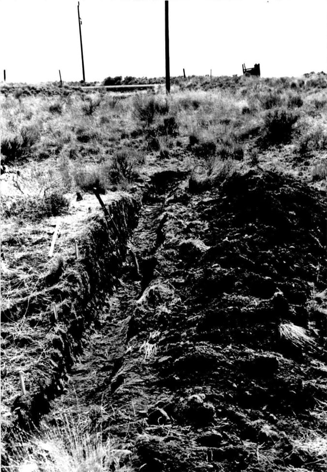
Clark Nelson dissected this desert mound near Shaniko in the 1970s, unlocking some of the secrets of how these soil mounds and rings of rock formed
For his field research, Clark Nelson camped out near the semi-ghost town of Shaniko, Oregon, where huge swarms of mounds fan out across the high plains. Nelson literally dissected a soil mound and its accompanying ring of stony “scabland” to understand how these features came to be.
Clark’s field work showed the soil mounds and their stone rings to be interrelated features, formed by the same freeze-thaw cycles during the past ice age, more than 11,000 years ago, when the Columbia Plateau was much colder and much wetter than today. Because these ice age conditions have long passed, Clark also found that the mounds themselves are no longer evolving, and instead are simply geologic relics frozen in time.
The ancient setup
According to Clark’s research, three ingredients set the stage for the formation of today’s desert mounds. First are the sprawling Columbia River flood basalts that cover much of eastern Oregon and Washington. It’s hard to comprehend the magnitude of these lava flows, as they originated near today’s Idaho border 16 million years ago and flowed all the way to the Oregon Coast of today. More than 300 of these massive flows spread for hundreds of miles over the millennia, burying the landscape in layers of basalt.
Today, we see these flood basalts prominently in the Columbia River Gorge, where the river has carved through them, revealing layer upon layer of basalt that forms rocky features like Crown Point and the cliffs behind Multnomah Falls. Clark found these expanses of solid bedrock to be an essential foundation for the soil mounds and rock rings.
The second ingredient came much more recently, at least in geologic time. As the last ice age began to wind down, continental glaciers that once extended as far south as Olympia (and scooped out the Puget Sound) began to retreat northward. The continental glaciers produced an immense amount of glacial silt that was spread far beyond the glacial extent over the millennia. We know today that wind played a major role in redistributing this glacial silt southward into Oregon, piling it in layers on top of the ancient Columbia flood basalts to depths of several feet.
Finally, the third ingredient is the ongoing building of the Cascade Range, which has laid down countless layers of volcanic ash across the Columbia Basin over time. When Clark Nelson dissected his desert mound near Shaniko, he found both the wind-blown glacial silts and volcanic ash interspersed in the soil layers that make up the mounds.
Nelson’s research also showed these layers of glacial and volcanic soil to be relatively undisturbed, and that the same sequence of layers could be found across groups of mounds in a given area. This observation casts further doubt on the gopher theory, since burrowing gophers would have mixed these soil layers up over time, had they been the builders of the mounds.
How the mounds formed
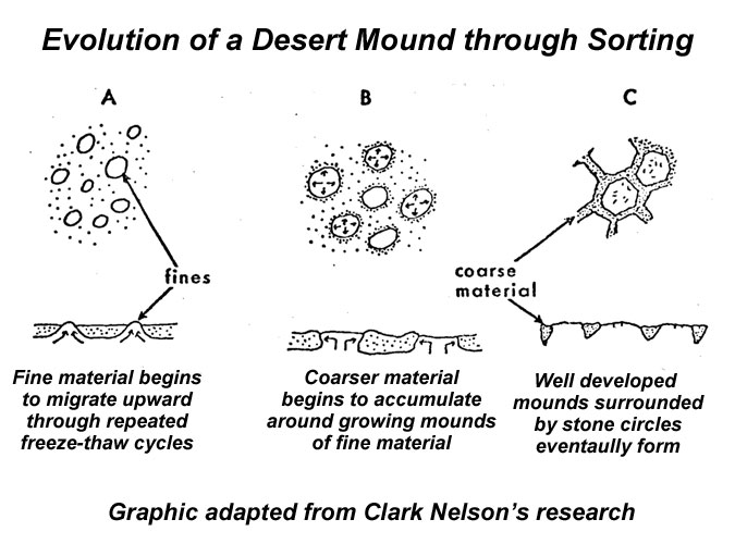
Clark Nelson believed the desert mounds and their rock rings formed through a process of natural sorting, where fine soil material is pushed up into mounds and rocks pushed out to the edges to form rings through countless cycles of freezing and thawing.
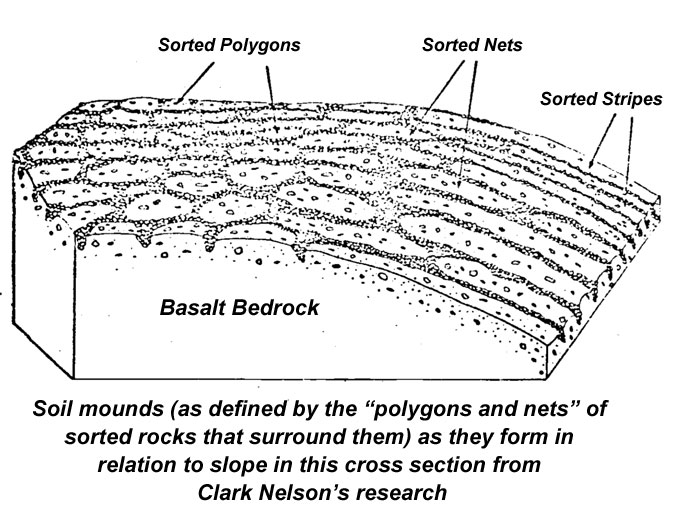
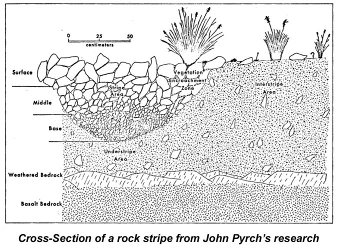
Nelson made his case with well-established research on the sorting effects of freeze-thaw cycles, and he argued that sorting on such a profound scale could only have happened during the end of the last ice age, when conditions were much colder and wetter than today’s arid desert climate. The schematic (below) is from Nelson’s thesis, and describes this process.
Nelson’s research also revealed that soil mounds tend to form where the soil depth is shallow atop the relatively impermeable basalt bedrock layer. As the schematic (below) from his thesis shows, the shallowness of the soil layer played an important role in forcing the sorting of rocks from fine soils through continuous movement from freezing and thawing.
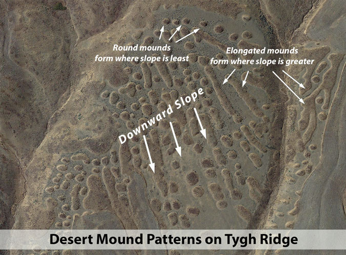
Nelson believed that this freeze-thaw process, played out over millennia, created the soil mounds and rock rings in flat or gently sloping areas where the mounds were more protected from surface erosion. He observed that mounds only formed on gently sloping terrain, with less than 10 percent slope, and that they became oblong as the slope increased.
He also observed that mounds formed in rows, aligned in the direction of the slope. This phenomenon shows the effects of gravity on the mounds as they formed, with their shapes stretching downhill when slopes increase. As shown in the first schematic in this article, Nelson described the interconnected rock rings that surround these round and oblong mounds as “nets”.
Finally, Nelson argued that only during the end of the Pleistocene epoch (the geologic term for the last ice age) would there have been enough moisture and cold to produce the thousands of freeze-thaw cycles needed to create today’s desert mounds. He believed that the climate that has since emerged in the Columbia Basin is not only too warm and dry to continue this sorting process, but that the desert climate has also protected the static mounds from erosion and being disturbed by forest cover.
According to Clark Nelson, this is the sequence of events left us with the thousands of desert mounds we see today. He makes a compelling case based on field research in our region that stands up well against other, more generic theories on the origin of soil mounds.
For his part, John Pyrch studied the origins of rock stripes that mark many of the steeper slopes in areas where soil mounds otherwise occur. Like Clark Nelson’s work, Pyrch’s research found these stripes to be relics of the last ice age.
First, Pyrch showed the strips to be distinct from common talus slopes, where an obvious source of rock at the head of the talus flow exists. Rock stripes lack such a source or falling rock. He also found that the desert rock stripes in the Columbia Basin aren’t moving like talus slopes, where rock is actively being added to the talus flow. Instead, rock stripes are gradually weathering but have become mostly static since their formation during the ice age.
Pyrch also observed that rocks within these stripes are sorted, unlike talus slopes, suggesting the same ice age freeze-thaw origins as soil mounds and rock rings. Pyrch and Nelson both believed the rock stripes were simply extensions of the rock circles that surround soil mounds on flatter ground, the rock “nets” that Nelson described. As the earlier schematic from Clark Nelson’s research shows, these “nets” of interconnected rock rings eventually become so elongated as slopes steepen that they become rock stripes.
Tygh Ridge Quarry
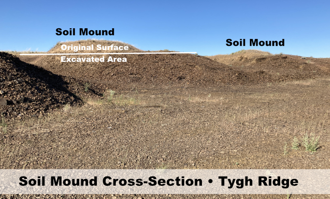
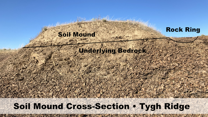
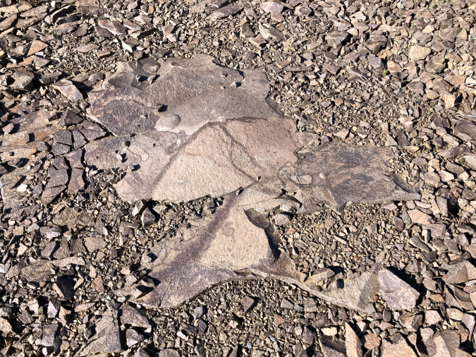
Clark Nelson’s dissected soil mound near Shaniko has likely disappeared under sagebrush after 40 years, but a small quarry near Tygh Ridge provides a fresh cross-sections of soil mounds that illustrate their origins, as explained by Clark Nelson and John Pyrch. About six feet of the underlying basalt bedrock has been quarried here, with several soil mounds and rocks rings bisected in the process, as shown below.
A closer look (below) at one of these quarried mounds shows the distinct soil layer perched on top of the bedrock, as well as a profile of the rock ring surrounding the mound.
A closer (below) look at the floor of the quarry reveals truncated columns of basalt from the ancient lava flows that make up the bedrock under the desert mounds.
Basalt columns make up the bedrock under the mounds
The importance of basalt in the development of the mounds comes from its impermeability. Nelson believed the poor drainage typical of basalt flows ensured regular ponding of surface water, and therefore ensured a ready supply of moisture to drive the freeze-thaw cycle when the Columbia Basin was much colder and wetter.
Seeing Desert Mounds on the Ground
Desert mounds can be tough to spot on the ground, precisely because they formed on flat or gently sloping ground. But the advent of modern mapping tools has brought these features to life in a way that John Pyrch and Clark Nelson could not have imagined in the 1970s. The following image sets combine Google Earth aerial imagery with on-the-ground photos of the same areas to give a sense of what the mounds look like at eye level.
The first schematic (below) shows a flat-topped ridge in the Deschutes Canyon, just south of Tygh Ridge, with a well-developed swarm of desert mounds plainly visible. The underlying basalt layers can also be seen at the margins of the ridge, and flow lines on the ridge top can be seen where rows of mounds are aligned in the descending direction of the slope.
Mounds in this schematic are round where the ground is flat, then become oblong in the direction of the slope where the ridge falls toward the canyon. The mounds finally disappear where slopes exceed 10 percent. This mound group does not include rock stripes, but in many similar examples, the stripes would continue down the canyon slopes below the lower limit of the soil mounds.
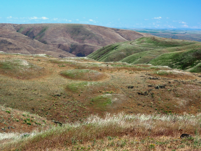
The following image shows what this terrain looks like on the ground in mid-spring, when the soil mounds are still holding moisture and supporting green vegtation, but the flat, shallow rock rings surrounding the mounds have already browned for the summer. This view is across a nearby ridge top in the Deschutes Canyon to the one shown in the previous schematic.
Mound swarm on a ridge top above the Deschutes River
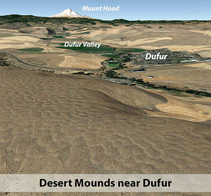
The small farming community of Dufur is surrounded mostly by wheat and alfalfa fields, but a sizeable swarm of desert mounds survives due east of the community. It’s unclear why some mounds have been flattened and plowed while others were passed over by farmers, but one possible explanation could be the original depth of the soil in the mounds, and whether enough soil existed in the mounds to support farming when plowed flat.
On the ground, desert soil mounds near Dufur (below) are also most prominent in late spring, when the mounds are still green with new growth but the surrounding rock rings have browned for the summer. This view shows three separate swarms of mounds, one in front of the closest row of trees, a second swarm between the rows of trees and a third on the distant slope.
Desert mound swarms near Dufur
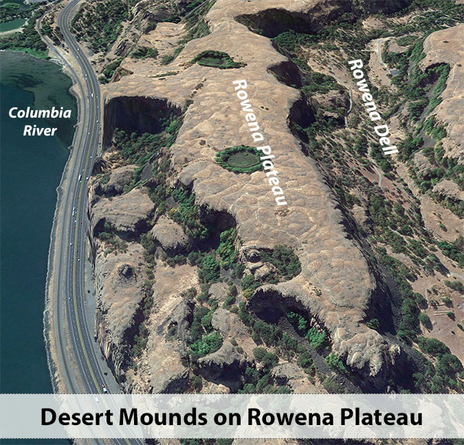
One of the most accessible places to see desert mounds is on the Rowena Plateau, in the Columbia River Gorge. These mounds formed at the western margin of where mounds occur in the Columbia Basin, but share all of the typical features of soil mounds.
This aerial schematic (above) shows a couple of ice-age features whose origins have been long-debated by geologists. First, the soil mounds show up prominently, and seem to fit the explanation given by Clark Nelson for their origin. But the plateau also includes at least two kettle (or “pothole”) lakes that are typically formed by ice age glaciers leaving blocks of ice behind that are initially buried in sediments, then melt to leave a depression, or “kettle” behind.
But the “kettles” at Rowena are formed in solid basalt flows, so geologists believe they were carved into the basalt by the series of massive ice age floods known as the Missoula Floods. They believe floodwaters eroded these depressions much like the potholes commonly found in rivers, except on a massive scale.
Timing is key to the story at Rowena, as the ancient floods also swept away all but the basalt bedrock on the plateau, and any soil mounds that had formed before the floods wouldn’t have survived. The Missoula Floods occurred more than 13,000 years ago, so with the ice age winding down by about 11,700 years ago, that leaves a window of less than 2,000 years for windblown glacial and volcanic sediments to accumulate here, and for freeze-thaw action to sort the sediments into the mounds we see today. Was that enough time for these mounds to have formed according to Clark Nelson’s theories? This uniquely narrow geologic window could make Rowena Plateau the place where the mystery of the desert mounds can finally be unlocked by researchers.
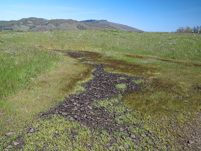
On the ground at Rowena Plateau, the rock rings are prominent between the soil mounds (below). Consistent with Clark Nelson’s theory of a standing water table atop the bedrock, they often form vernal pools in winter and spring.
Rock rings surrounding the soil mounds at Rowena
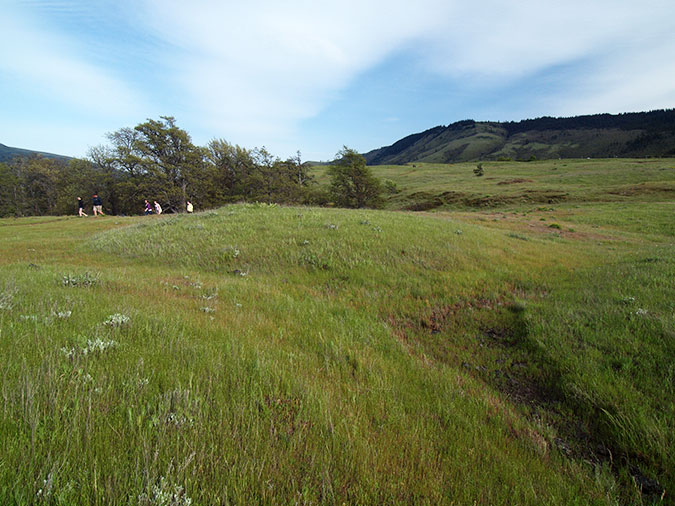
Hikers on the plateau may not recognize the mounds as geologic features, but they cover most of the plateau and are surprisingly easy to spot, along with their network of rock rings (below).
Hikers passing through the soil mounds at Rowena
In this view (below), a hiking trail weaves among the mounds as it makes its way across the plateau, much as pioneer wagons must have dodged the desert mounds in the mid-1800s.
Trail meandering between desert mounds on the Rowena Plateau
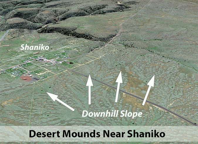
Clark Nelson chose the Shaniko plateau for his field research in the 1970s, and it’s easy to see why from modern aerial photos, as shown in the following schematic (below). The terrain here slopes gently toward the surrounding canyons, creating the perfect geologic setup for soil mounds.
The expansive extent of the desert mounds at Shaniko also shows how closely their formation follows slopes, with mounds radiating from a barely discernable high point in the plateau toward the canyons beyond the town.
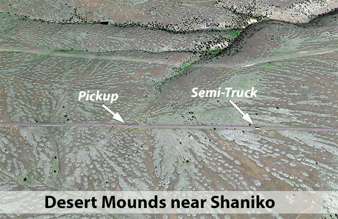
This second view (below) of the Shaniko swarm of desert mounds provides some context, with a pickup truck and semi-truck captured in the aerial imagery for scale.
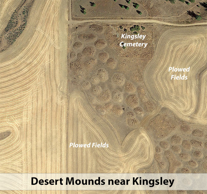
In the tiny farm community of Kingsley, located a few miles south of Dufur and west of Tygh Ridge, there are more headstones than residents these days, with two pioneer cemeteries providing close-up views desert mounds. In this aerial view (below) a swarm of desert mounds has survived the plows next to the Kingsley Cemetery. Many other isolated mound swarms are located throughout the Kingsley area.
On the ground, the Kingsley mounds are prominent, especially in mid-spring when wildflowers and native grasses flourish on the mounds. The rock rings surrounding these mounds (below) are also well-developed and easy to see.
Green-topped desert mounds in spring surrounded by barren rock rings at Kingsley
As summer sets in and the desert green fades to brown, desert mounds are harder to spot. This view (below) shows the same group of mounds near the Kingsley Cemetery in June, as the last spring wildflowers on top of the mounds are fading to brown for the year.
Tawny summer colors taking hold on a swarm of soil mounds near Kingsley
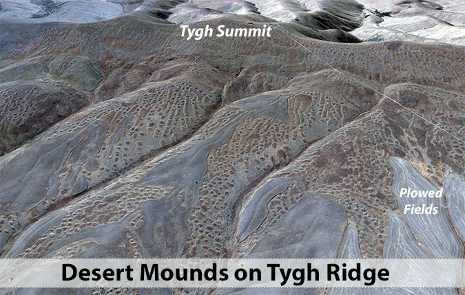
Tygh Ridge is a broad, uplifted fault that forms the north wall of Tygh Valley and the lower White River canyon. The south side of the fault is steep, dropping abruptly into Tygh Valley and Deschutes River canyon, while the north slope is broad and gentle, extending nearly 10 miles toward Dufur. Because of its geology and gentle slope, the north side of Tygh Ridge provided the perfect conditions for thousands of ice age desert mounds to form. Though many have disappeared under plowed fields, thousands remain.
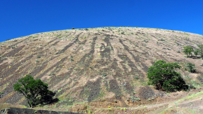
The aerial view in the following schematic (below) shows the swarms of mounds that seem to flow down the slopes of Tygh Ridge, and also how the mounds stretch into oblong shapes as slopes steepen into the ravines that radiate from the ridge.
A closer look at Tygh Ridge from the air (below) shows the relationship of mound shapes and orientation to the sloping terrain of the ridge. The mounds do seem to be “flowing” downhill. In a way they are, but only to the degree that the freeze-thaw sorting process that created these features was also shaped by gravity.
A closer aerial view (below) of this area on Tygh Ridge shows the order of the mounds strikingly, with longer mounds marking slopes and round mounds formed were the terrain is flatter. These patterns and the predictable order of the mounds on Tygh Ridge clearly defies the “gopher theory” that has found new life among scientists.
The desert mounds here are plainly too ordered and predictable to be the work of gophers. Did gophers build soil mounds elsewhere in the world? Possibly. But the patterns we see in the Columbia Basin seem best explained by on-the-ground, freeze-thaw research by John Pyrch and Clark Nelson.
The desert mounds on Tygh Ridge are everywhere, though much less obvious on the ground than in aerial photos. This scene (below) shows why. The crest of Tygh Ridge, which forms the backdrop in this view, is almost entirely covered in desert mounds, and yet their low profile and the gentle slopes nearly hide them when viewed from ground level.
Historic barn on the high slopes of Tygh Ridge
However, the closer you get to desert mounds on the ground, they more they begin to emerge in profile. These mounds on Tygh Ridge are typical, with wildflowers and bunch grasses established in the deep soil of the mound, and sparse growth in the rock rings that surround the mounds.
Mount Adams peeks between soil mounds on Tygh Ridge
Large areas along the north slope of Tygh Ridge remain unplowed, providing one of the best field laboratories for further understanding the phenomenon of desert mounds. Because the area is uplifted, it’s also some of the highest terrain (ranging from 2,500 to over 3,000 feet) in the Columbia Basin to show the desert mound phenomenon, which also might be of value for future research.
Rock Stripes
Rock stripes are abundant on the slopes of Tygh Ridge in Butler Canyon
Tygh Ridge not only has impressive displays of desert mounds, it’s also home to some of the best rock stripe examples in the area. Once group is located on a prominent shoulder of Tygh Ridge in Butler Canyon, where OR 197 crosses the ridge.
Though this shoulder of Tygh Ridge (below) looks like an isolated bluff, it’s really just the end of a long ridge, with hundreds of desert mounds spread across the gentle crest of the ridge, out of view. It’s on the steep shoulders of the ridge that John Pyrch’s theory of rock stripes plays out. There is clearly no source of rock to feed these strips, and they are not migrating downhill like a talus slope might. Pyrch showed these to be are barely moving at all, in the absence of the ice age moisture and heavy freeze-thaw cycles that sorted them into stripes.
Rock stripes in Butler Canyon
A closer look (below) at rock strips on another shoulder of Tygh Ridge shows how the stripes correlate to the slope and to one other, marking the direction of the slope.
Rock stripes on Tygh Ridge
While not as clearly formed as their desert mound and rock ring cousins, there is order here, with the stripes alternating with long islands of soil that Pyrch and Nelson believe are simply soil mounds becoming increasingly elongated by gravity as they slopes they formed upon became steeper.
(Author’s note: do you know John Pyrch or Clark Nelson? I tried to located them for this article with no luck, but would love to hear from them!)
_____________________
The Desert Mound Tour!
View from below the Kingsley Cemetery
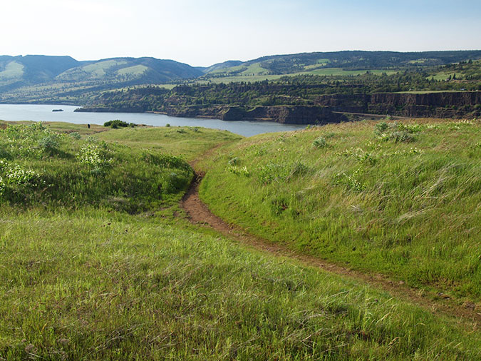
If you’re up for a road trip, there’s a lonely and scenic loop through the Tygh Ridge area that provides close-up looks at desert mounds, along with sweeping views of the Cascades (on a clear day). In May and June, the route is lined with wildflowers, but the trip is fascinating to explore through summer and fall, as well. A pair of nearly forgotten pioneer cemetaries along the way make for interesting stops, too, and both are filled with wildflowers in spring.
Though this makes for an easy day-trip in a car, it could also work as a bicycle tour for cyclists open to some well-maintained gravel roads mixed in with the paved sections. With the exception of a couple of OR 197 sections along the loop, there is little or no traffic to contend with — and even the highway is lightly traveled. This is lonely country!
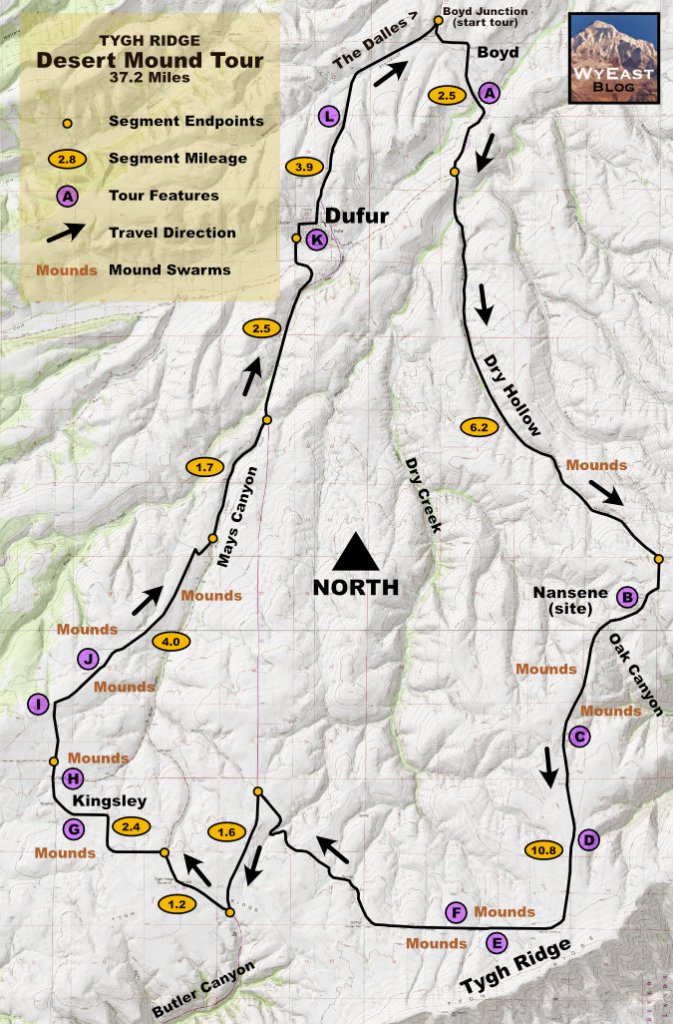
Here’s a map of the loop, along with a link to a larger version to print for your trip:
The highlights of this 37-mile tour are keyed to the purple dots on the map and mileage for segments between the small orange dots is shown in the orange ovals. Here’s a segment-by-segment description of the tour:
1. From The Dalles, drive south on OR 197 for 8.7 miles to the Boyd Junction and turn left onto the Boyd Loop road. The tour begins here. Continue on this road toward Boyd.
Soon you will make a dogleg turn to the right through the tiny community of Boyd, then reach the beautiful Adkisson Bridge(A on the map) over Fifteenmile Creek. This historic 1925 structure was designed by Conde McCullough, the famed Oregon bridge engineer who designed most of the stunning bridges along the Oregon Coast Highway and several of the graceful bridge along the old scenic highway in the Columbia River Gorge. The nearby, historic Adkisson Mill completes the picturesque scene here. There’s a small pullout on the south side of the bridge.
Historic Adkisson Bridge designed by famed designer Conde McCullough
2. Reach a signed intersection with Dry Hollow Road 2.5 miles from Boyd Junction. Stay straight here and continue 6.2 miles up Long Hollow Road.
As travel through Long Hollow, you’ll notice the steep slopes of the hollow have kept the farmer’s plows mostly at bay, providing a glimpse of what the entire area once looked like, with sagebrush and wildflowers covering the desert landscape. In spring, blue Lupine and yellow Buckwheat are the predominate wildflowers here and throughout the tour. You might see deer and even antelope along this part of the tour, too, and the first desert mounds will come into view (shown on map).
A remnant of the natural desert landscape surives in Long Hollow
3. At a 3-way junction with Center Ridge Road and Tygh Ridge Road, turn right and begin following Tygh Ridge Road for the next 10.8 miles. This road is intially paved, but then turns to well-maintained gravel.
Immeidately after turning onto Tygh Ridge Road, watch for a wide shoulder pullout on a curve at the picturesque remains of the Nansene Community Hall (B on the map), located on the west (right) side of the road. This fading structure has its origins in the early 1900s when the area was still a center for sheep ranching. Now, it stands as the sole reminder of the community of Nansene, and its main residents are the hundreds of barn swallows that swoop in and out of the building and serenade visitors.
Historic Nansene Community Hall and Mount Hood
In spring, the meadows opposite the community hall (on the east side of the road) are filled with blue lupine and a view down Oak Creek Canyon toward the Deschutes River. There are great views of the meadow from along the fenceline, so please respect private property here. The view from Nansene also includes four Cascade volcanoes on a clear day: Mount Jefferson, Mount Hood, the top of Mount St. Helens and Mount Adams!
Continuing south on Tygh Ridge Road, several desert mounds appear along both sides of the road. Watch for the quarry described earlier in this article if you’d like to inspect soil mounds that have been dissected. The soil mound quarry(C on the map) is on the east side of the road. This is private land and may be gated, though the quarried mounds are visible from the main road.
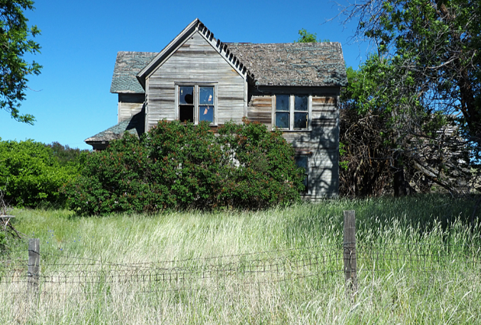
Where Tygh Ridge Road turns to gravel, look to your left for a picturesque, abandoned farmhouse (D on the map) that dates back to the days of sheep ranching, but please observe private property here. There’s a pullout on the right side, opposite the farmstead.
Abandoned farmhouse along Tygh Ridge Road
Continue on Tygh Ridge Road as it gradually turn to the west, and begins to parallel the crest of Tygh Ridge (the long, gentle ridgeline to the south with communication towers marking its summit). Tygh Ridge and nearby Tygh Valley were named for the native peoples who lived in the area before white settlement in the mid-1800s.
In 1845, Tygh Ridge also saw the ill-fated Stephen Meek party pass through in a harrowing effort to reach The Dalles after losing their way on the Meek’s Cutoff. The “cutoff” was a supposed shortcut along the Oreogn Trail, but it turned into a dead end for the 200 wagons and 1,000 white emigrants in Stephen Meek’s party when they reached the chasm of the Deschutes Canyon. At this point, the party had come to realize that Meek had never traveled the route and they were now lost.
Mountain man Stephen Meek in the 1860s
Starving and desperate, the Meek party crossed the Deschutes River at Sherar’s Falls, using ropes to haul their dissembled wagons across in an effor that took two weeks. From there, they somehow scaled Tygh Ridge with the help of a rescue party and eventually reached The Dalles.
Dozens died along the disatrous Meek’s Cutoff trek, and many more died of exhaustion after reaching the The Dalles in October 1845. As you travel across the sweeping north slopes of Tygh Ridge, it’s easy to imagine these weary emigrants to Oregon making their way across this terrain in creaky wagons. Their story was made into the acclaimed film “Meek’s Cutoff” in 2010.
In the westward section of Tygh Ridge Road, the continuous view sweeps from Mount Hood to Mount Adams on a clear day. Watch for a rustic, century-old barn on the left (E on the map) and several wildflower meadows and swarms of soil mounds and their accompanying rock rings on the right (F on the map) in this section of the tour.
4. Continue following Tygh Ridge Road until you reach OR 197. Turn left here in the direction of Tygh Valley, following the highway for 1.6 miles south to Dufur Gap Road, just beyond the Tygh Summit marker. Turn right to continue the tour on Dufur Gap Road.
You will now enter the Kingsley portion of the tour, which has some of the most accesible and interesting desert mounds in the area. There are several mounds in a swarm located along the east (right) side of Dufur Gap Road. This quiet road was the original highway through the area until it bypassed in the 1960s by the modern OR 197.
5. After traveling 1.2 miles on paved Dufur Gap Road come to the junction with Kingsley Road. Turn left (west) and follow gravel Kingsley Road for the next 2.6 miles.
As you continue through the Kingsley district, you’ll pass more swarms of desert mounds that have survived the plows. I’ve dubbed one group of these mounds (G on the map) as the “Garden Mounds”, as they are topped with a beautiful display of wildflowers in spring and frame a nice view of Mount Hood (see photo, below).
“Garden Mounds” along Kingsley Road with Mount Hood on the horizon
You probably won’t realize that Kingsley Road has became Hix Road at a bend by a farmhouse, but soon the route reaches a short paved section along this part of the tour, where Friend Road briefly joins Hix Road. There’s is an excellent group of desert mounds and rock rings at this intersection (H on the map), with views south to Mount Jefferson and Postage Stamp Butte. The latter is the broad western extent of Tygh Ridge and once had a fire lookout on the summit. The mounds here have especially well-developed rock rings and vernal pools in winter and spring.
6. From the junction with Friend Road, continue north along a brief paved section, then keep straight where paved Friend Road veers left and gravel Hix Road heads north. Continue on Hix Road for the next 4.0 miles.
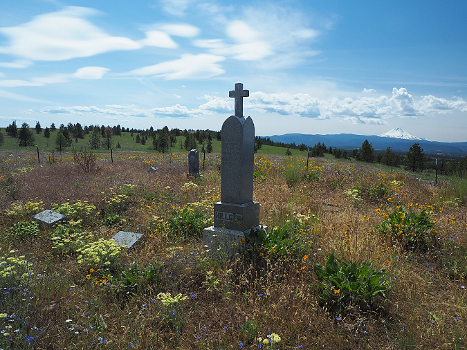
Heading north on Hix Road you’ll pass another farmhouse on the right before reaching a sharp right turn, where a rough, dirt road heads off to the left toward a stand of Ponderosa pine on a low crest. If you love pioneer cemeteries but fear deep ruts, I recommend parking on the shoulder here and making short walk up this road to the pioneer Kingsley Cemetery (I on the map). Thanks to the rough access road, this is one of the loneliest places around, and in spring, yellow Balsamroot fill the cemetery. Mount Hood is big on the horizon and there are also some nice soil mounds bordering west and south sides of the cemetery.
Just beyond the dirt road spur to the Kingsley Cemetery, watch for the Kingsley Catholic Cemetery on the north side of the road (J on the map). Park on the north shoulder for a short walk to tour this beautiful pioneer cemetery, where the views on a clear day include Mount Hood, Mount St. Helens and Mount Adams. Soil mounds border this cemetery, as well, and are covered with blue Lupine and yellow Buckwheat in late spring.
Kingsley Catholic Cemetery
The family plots in Kingsley Catholic Cemetery include a surprising number of grave markers for children, a poignant reminder that at the turn of the 20th Century the child mortatilty rate was nearly 1 in 5 in our country, thanks to deadly childhood diseases that have since been nearly eliminated by modern vaccines.
As you resume the tour heading northeast on Hix Road, you’ll pass still more swarms of soil mounds on the right and a couple more ranches as the road makes a gradual descent to Mays Canyon. On the far horizon, you can pick out the wrinkled Columbia Hills that mark the north wall of the Columbia River Gorge and some of the hundreds of modern, white windmills that now rise along the ridges of the Columbia Basin.
7. Reach a junction with paved Dufur Gap Road 4.0 miles from where Hix Road left paved Friend Road. Head left on Dufur Gap Road and travel 1.7 miles to a junction with OR 197.
This section of Dufur Gap Road travels through Mays Canyon, where you will pass several farm homes and likely see deer and possibly antelope along the way, as well as the distinctive magpies that are common in Oregon’s desert country.
You may also have noticed burned trees scattered throughout the Kingsley and Mays Canyon segments of the tour. These were victims of the massive Substation Fire that burned nearly 80,000 acres in July 2018. Though the ground was blackened across much of the area, wheat fields and wildflower meadows have since covered most traces of the fire in just two years, with only the scattered tree snags to remind us of the event.
8. At the junction with OR 197, turn left onto the highway and continue north 2.5 miles to Dufur, forking left onto Dufur Valley Road where a sign points to Dufur, and staying straight when the town of Dufur comes into view.
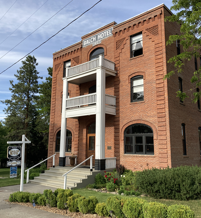
Be sure to make a stop at the Historic Balch Hotel(K on the map), which offers vintage lodging and fine meals. It’s the large brick structure on the right as you pull into this small town. Dufur has lots to offer, and makes a nice lunch stop for the tour, including a city park for picnicking.
Historic Balch Hotel in Dufur
If you make the tour during the second week of August, you’ll miss the spring wildflowers but be just in time for Vintage Dufur Days — known to old-timers as the Dufur Threshing Bee. And remember, when John F. Kennedy visited Dufur during his 1960 presidential campaign, he famously challenged the locals with “Ask not what Dufur can do ‘fer you, but rather, what you can do ‘fer Dufur!”
9. Continue through Dufur and rejoin OR 197 on the north end of town. Turn left toward The Dalles and head 3.9 miles to the Boyd Junction, which concludes the tour loop. Continue north on OR 197 to return to The Dalles.
The last secion of the tour follows OR 197 through more ranch country, but if you’re still up for another pioneer cemetery stop, don’t miss the well-maintained Dufur Community Cemetery (L on the map), located on the west (left) side of the highway, just north of Dufur. Watch or a grove of locust trees, the somewhat hard to spot cemetery driveway is just beyond. Graves here date back to the 1860s and trace some of the earliest white settlement in Oregon, when Dufur was along the Barlow Road route used by white settlers to reach the Willamette Valley. Mount Hood fills the western horizon on a clear day.
Big Jim’s Drive-in is a local institution in The Dalles
Still feeling hungry before the drive home? No trip to The Dalles is complete without a stop at Big Jim’s Drive-in, located just west of OR 197 on Highway 30, near the I-84 interchange. It has been a comfort-food institution in The Dalles since the 1960s.
You can go fancy at Big Jim’s with salmon and chips (or even grilled wild salmon!), but I recommend starting with the Jim Dandy burger basket. The house fries are excellent, and if you’re an onion ring fan, be sure to request the upgrade for $1 (or order both! You won’t regret it… though your cardiologist might). In our pandemic era, Big Jim’s has patio seating, a drive-thru and you can even call an order in from a marked space in their parking lot and have it delivered to your car window.