
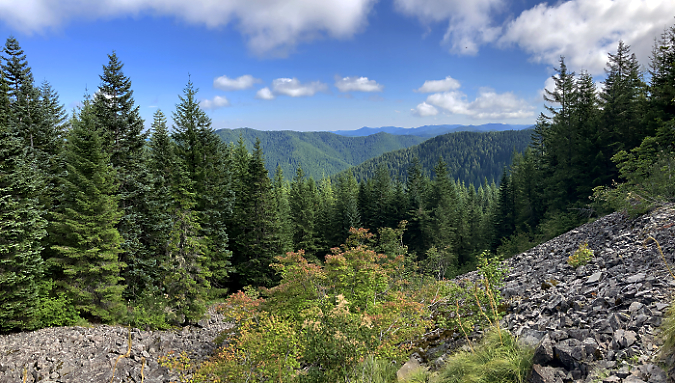
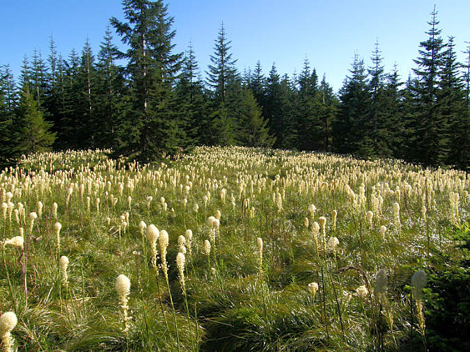
Wildcat Mountain’s (now) forested summit as viewed from a surviving meadow along McIntyre Ridge
From Portland, the broad, densely forested slopes of Wildcat Mountain blend in with the surrounding Cascade foothills. The Mount Hood Loop Highway ruses past the northern foot of the mountain (the iconic Ivy Bear restaurant is located by Wildcat Creek, one of many streams that flow from the mountain). Wildcat Mountain Road (Forest Road 36) is the main access to the area, along with its extension, Forest Road 3626. Both are paved roads, and provide quick access from nearby communities to the west.
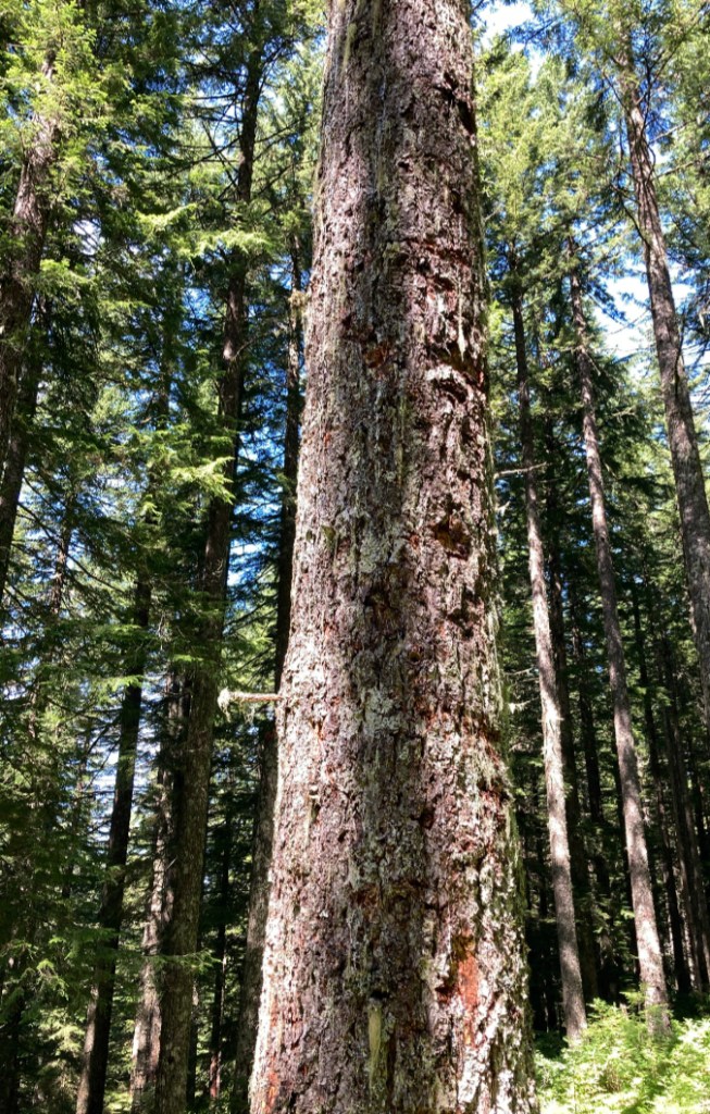
A century ago, the Wildcat Mountain was much different. Historic fires had repeatedly swept across the its slopes, creating sprawling Beargrass meadows along the broad northern shoulder of Wildcat Mountain known as McIntyre Ridge. Sheep were grazed here in the late 1800s and a fire lookout was constructed on the (then) bald, windswept summit of Wildcat Mountain in the 1930s.
White migrants to Oregon arriving along the Barlow Road in the mid-1800s made land claims to the lower slopes of Wildcat Mountain, logging the forests and clearing pastures that are still farmed today. The unclaimed upper slopes were eventually incorporated into the Cascade Range Forest Reserve in 1893, a predecessor of today’s Mount Hood National Forest. This marked the beginning of aggressive fire suppression in our national forests and heavy logging of the standing trees on the mountain.

This 1933 view from the (then open) summit of Wildcat Mountain shows the wide-open expanse of McIntyre Ridge spreading out to the north, thanks to repeated fires that maintained the extensive Beargrass meadows. Only fragments of these meadows survive today
Most of the claimed lands on the lower slopes of Wildcat Mountain have since been acquired as corporate timber holdings, and these forests have been repeatedly logged since the mid-1900s. The Forest Service logged much of the unburned forest on public lands on the middle slopes of Wildcat Mountain from the 1950s through the late 1980s. Meanwhile, fire suppression was allowing the open, upper slopes on McIntyre Ridge to gradually reforest.
As recently at the late 1960s, when Don and Roberta Lowe’s classic “100 Oregon Hiking Trails” was published, the old lookout trail along McIntyre Ridge to the summit of Wildcat Mountain still passed through broad meadows. They described being able to pick out the downtown buildings of Portland from the open summit. And as recently as the early 1990s, Mount Hood could still be easily seen from the top of Wildcat Mountain, though a rising forest of Mountain hemlock and Noble fir were rapidly advancing toward the summit.
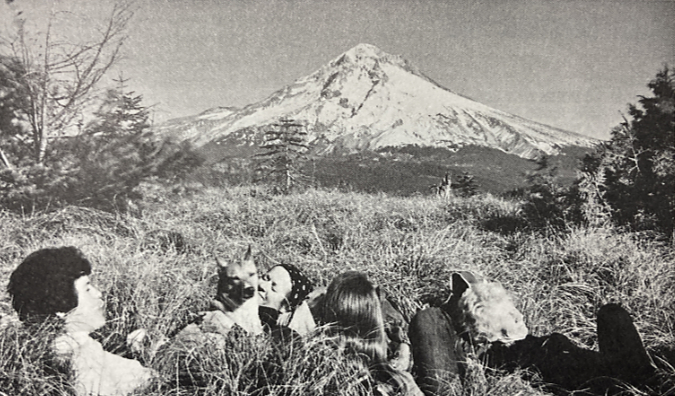
Roberta Lowe and friends enjoying the view that existed on Wildcat Mountain until forests overcame the summit in the 1990s (from “62 Trails Northern Oregon Cascades” by Don & Roberta Lowe)
Today, the view from the summit of Wildcat Mountain has all but disappeared, mostly overtaken by the advancing forest. If you know where to look, you can still find remains of the old forest lookout among the trees. McIntyre Ridge still has a few Beargrass meadows along the historic lookout trail, though most have also been overtaken by forest. But this is a temporary state, as recent wildfires in the Gorge and on Mount Hood have reminded us. Wildcat Mountain will burn again, and there’s good reason to believe that the summit and McIntyre Ridge burned fairly regularly in the past, before human fire suppression.
The Struggle for Wildcat Mountain
The changes to Wildcat Mountain’s forests and meadows over the past several decades are just part of the story. The area has also been a source of intense struggle over public land management. The Forest Service aggressively managed the forests here for log production well into the 1980s, and this helped trigger the creation of the 62,000-acre Salmon-Huckleberry Wilderness in 1984. Wildcat Mountain and McIntyre Ridge formed the western edge of the new preserve. At the time, the new wilderness was unique in that it focused primarily on protecting forests, whereas Oregon’s wilderness areas prior to 1984 were mainly “rock and ice” preserves centered on the big Cascade peaks, away from prime logging areas.

Mount Hood emerging from the clouds after a November snowfall on Wildcat Mountain. This scene was captured in 1989 as Pacific rhododendron and young Noble fir were beginning to overtake the once open summit
However, the creation of the Salmon-Huckleberry Wilderness did little to change Forest Service management of the public lands adjacent to the new wilderness, and the focus on logging continued on the remaining, unprotected slopes of Wildcat Mountain. The resulting tangle of logging roads on both public and private lands in this area became a magnet for illegal off-road vehicles and target shooting, largely because its close proximity to Portland. This has become a serious and ongoing challenge for forest managers and law enforcement.
Forest Service logging on Wildcat Mountain had mainly focused on areas below Forest Road 3626, which contours across the gentle west slope just above the 3,000-foot level. This did not go unnoticed by conservationists and the Oregon Congressional delegation, and in 2009, most of the remaining uncut forests on Wildcat Mountain were added to the Salmon-Huckleberry Wilderness by Congress, with Road 3626 serving as the expanded wilderness boundary.

Salmon-Huckleberry Wilderness boundary sign along the Douglas Trail
This more recent expansion of the wilderness has only added to tensions with target shooters and off-road vehicles. Both groups have had a heavy impact on the area in recent years, with shooting galleries littered with trash and large trees literally felled by overwhelming gunfire. Off-roaders have illegally pushed miles into the wilderness, creating new “roads” to bypass Forest Service barriers. Illegal dumping also become a problem, adding to the problems facing land managers.
Timber corporations have responded to the lawlessness by closing their lands to any shooting, and the Forest Service closed a 4-mile section of Forest Road 12 to target shooting, as well. This has had the unintended effect of pushing target shooters and off-roaders still further along Forest Road 3626, and into the Salmon-Huckleberry Wilderness.
Most of today’s shooters aren’t hunters. They’re usually young, suburban kids packing high-powered weapons and handguns and showing little respect for our public lands. These shooters were in a closed area immediately adjacent to Wildcat Mountain Road
Sadly, the lawlessness in the area has also had dampening effect on hikers, a negative feedback loop that only encourages more lawless behavior. Illegal target shooters, off-roaders and dumpers go to places where they think they won’t be seen. Bringing more hikers to Wildcat Mountain is one of the best and most sustainable ways to discourage these illegal activities. It’s a proven concept known as “eyes on the forest”.
But it’s going to take some work. Today, the vandalized trailheads, shot-up or missing signage and vanishing trail views on the mountain are combining to make this convenient, beautiful wilderness destination an afterthought for hikers as they head for already crowded, more distant options where they won’t have to confront these problems.

Bullet-riddled sign announcing the Forest Service ban on shooting along sections of Forest Road 3626 on Wildcat Mountain. This sign was eventually destroyed by shooters
Shooters along Wildcat Mountain Road and Road 3626 have toppled dozens of full-sized trees with thousands of rounds fired at targets attached to the trees, or simply in a deliberate effort to drop them
On a recent visit to the New McIntyre Trailhead, I pulled up behind a truck full of young shooters. I hopped out and said “hello” and began to pull out my pack and hiking poles. When they realized I wasn’t going anywhere soon, they abruptly packed up and left. Even better, three more groups of hikers arrived shortly thereafter — and I’m quite certain other shooters came upon this group of parked cars that day and reversed course, too. That’s how the “eyes on the forest” effect of positive, legal recreation can chase away lawless activity.
Off-roaders have been increasingly bold in crossing into the Salmon-Huckleberry Wilderness in the Wildcat Mountain area in recent years. When the Forest Service placed boulders at the New McIntyre Trailhead in the mid-2000s, off-roaders simply pushed through a new “road” through dense forest to skirt the boulders. This illegal road continues to be used by off-roaders to take their trucks and ATVs into the wilderness area today.
The “road” on the left was created illegally by off-roaders in jeeps and ATVs in the late 2000s to bypass barriers placed at the McIntyre Ridge Trailhead. The actual trail is on the right and leads to the trailhead
The lower portion of the McIntyre Ridge Trail travels through open forest on a very old forest road. This has allowed off-roaders to drive along the trail for nearly a mile into the wilderness area, damaging both the trail and the forest floor where they have simply created new routes where logs have fallen across the trail, blocking their path.

The McIntyre Ridge Trail is on the left, but off-roaders created the road on the right to bypass the two trees flanking the trail. This spot is one-half mile inside the Salmon-Huckleberry Wilderness

A tree dropped across the McIntyre Ridge Trail in 2019 and off-roaders simply plowed through the forest on the left to create a new route for their vehicles, This spot is well inside the wilderness boundary
Off-roaders have been chopping down trees to widen the McIntyre Ridge where the trail narrows about a mile from the trailhead, an outrageous violation of federal law in a protected wilderness area
Where the McIntyre Ridge Trail eventually narrows, off-roaders have even been cutting trees to push their vehicles further into the wilderness. This level of lawlessness has been happening for many years, and it long past time to finally shut it down.
This article contains a series of modest proposals for turning the situation around on Wildcat Mountain by making it preferred hiking destination through improvements to the trails and trailheads. These include new signage, improved trailheads and some creative trail re-routing to bring back the views that hikers look for in their trail experience. How can this be done? More on that at the end of this article.
The Trails
Wildcat Mountain will burn again, and if the series of large fires on Mount Hood and in the Columbia River Gorge are any indication, we will see fire much more frequently in this century as a result of heavy fire suppression in the 20th Century. Someday, Wildcat Mountain and McIntyre Ridge might even return to the expansive complex of meadows that once existed here over time.
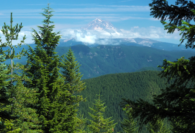
Mount Hood from the lower McIntyre Ridge Trail
Until that day, there are still magnificent views to be had if you know where to look. On the existing McIntyre Ridge Trail to Wildcat Mountain, two prominent viewpoints remain — a pocket view of Mount Hood near the trailhead (pictured above) and a more sweeping view of the mountain from a surviving meadow further along the ridge.
This latter viewpoint is the focus for most who hike the McIntyre Ridge Trail. Some years ago, the Forest Service allowed a memorial bench to be installed here, and though it is gradually collapsing under the weight of winter snows, the view it was designed for survives. This spot is often called the “Bench Viewpoint”, and remains a popular hiking destination, despite the problems in the Wildcat Mountain area.

The “bench” viewpoint along the McIntyre Ridge Trail, the most common destination for hikers today
But it turns out that a couple more viewpoints are tucked into the forest just off the McIntyre Ridge Trail, and with some modest trail realignments they would make for a much more scenic gateway into the Salmon-Huckleberry Wilderness.
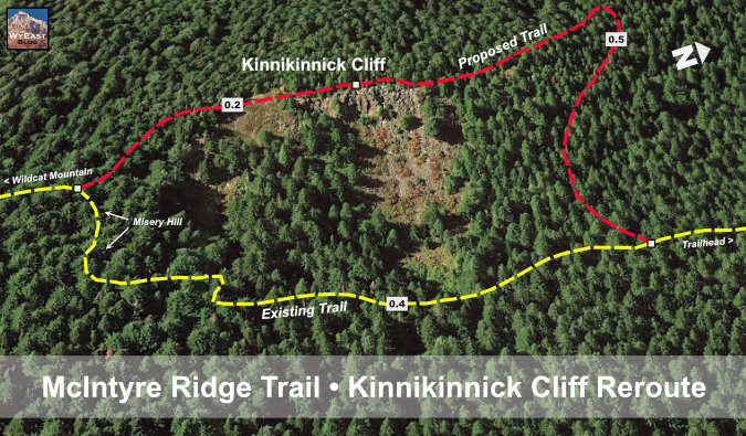
The first is a rocky wall called “Kinnikinnick Cliff”. It rises directly above the existing trail, and offers a commanding view of Mount Hood and the entire Hoodland corridor, 3,000 feet below. Mount Adams, Mount Rainier and the Goat Rocks can be seen to the north, and the rugged canyons and forested ridges of the Salmon-Huckleberry Wilderness spread out to the southeast. This viewpoint is just over a mile from the unofficial New McIntyre Trailhead and would offer a nice option for casual hikers who want to experience wilderness with big views.
Kinnickinnick Cliff is mostly unseen from the McIntire Ridge Trail, though it rises directly above it in a rugged wall with sweeping view

Mount Hood rises above the Salmon-Huckleberry Wilderness in this panoramic view from Kinnickinnick Cliff. Smoke from the White River fire is visible in this August 2020 view, partly obscuring the mountain. Mount Adams and Mount Rainier can also be seen also on the northern horizon
[click here for a large version of the panorama]
Rerouting the existing trail to visit Kinnikinnick Cliff also has the benefit of bypassing an especially tedious section along the existing trail that I call “Misery Hill”. Though not particularly long, it’s very steep and badly eroded, and there’s no way to fix this problematic section of trail without a major reroute. Thus, the concept of moving the trail to the top of Kinnikinnick Cliff to provide a better grade along with a spectacular new view.
The “Misery Hill” section of the McIntyre Ridge Trail interrupts and otherwise well-graded trail and should be bypassed
The second hidden viewpoint is also just off the existing trail, located south of Kinnikinnick Cliff and just north of the largest of the remaining Beargrass meadows along the trail. This view is from the top of a beautiful talus slope that drops down the east side of McIntyre Ridge. The vista extends across the remote Boulder Creek canyon, below, and into the heart of the Salmon-Huckleberry and Roaring River wilderness areas. Mount Hood also peeks between the trees along the north edge of the talus viewpoint.
The talus viewpoint is just a few yards off the existing McIntyre Trail and provides a view deep into the remote ridges and canyons of the Salmon-Huckleberry and Roaring River wilderness areas
[click here for a large version of the panorama]
Rerouting the trail to visit the Talus Viewpoint is straightforward. Though hidden from the existing trail, the viewpoint is only 100 feet away, separated from the exiting trail by a low ridge. A modest realignment in the trail would add the Talus Viewpoint as another scenic highlight and destination for hikers along the McIntyre Ridge Trail.
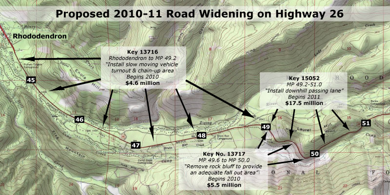
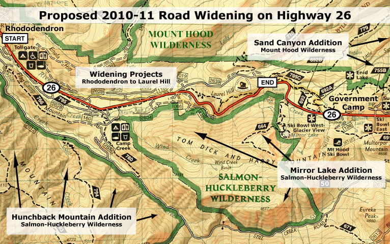
The following maps show these proposed trail concepts:

[click here for a large version of this map]
[click here for a large version of this map]
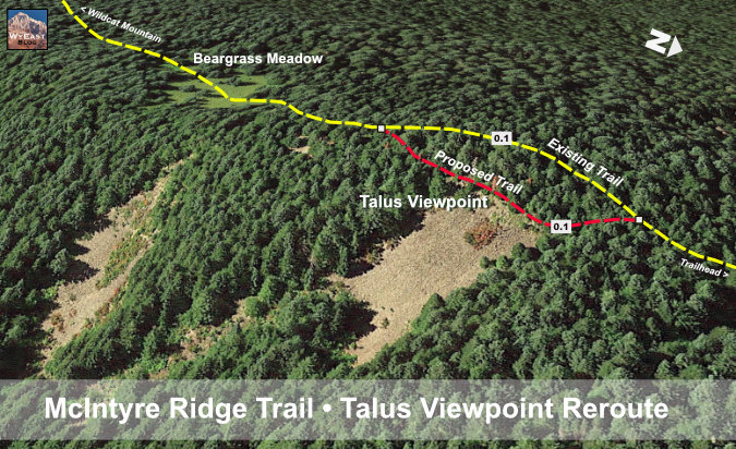
[click here for a large version of this map]
Taking hikers to new viewpoints is a great way to increase interest in the Wildcat Mountain area, as well as make the wilderness experience more satisfying for anyone hiking the McIntyre Ridge Trail. Just a few more law-abiding visitors to the area could have a big impact on pushing the unlawful activity away from Wildcat Mountain, too — a virtuous cycle that is within reach.
The Trailheads
Hikers will put up with a lot to reach a favorite trail, but they shouldn’t have to. Until just a few years ago, the McIntyre Ridge Trail was accessed from Highway 26, where an especially rough Bureau of Land Management (BLM) logging spur climbs the north end of the ridge. This miserable route ended abruptly in the middle of a clear cut, with little room for parking. Worse, shooters and vandals were trashing the area. Because of this, the BLM abruptly closed the access road in the mid-2000s, with no consideration for an alternative access to the McIntyre Ridge Trail.

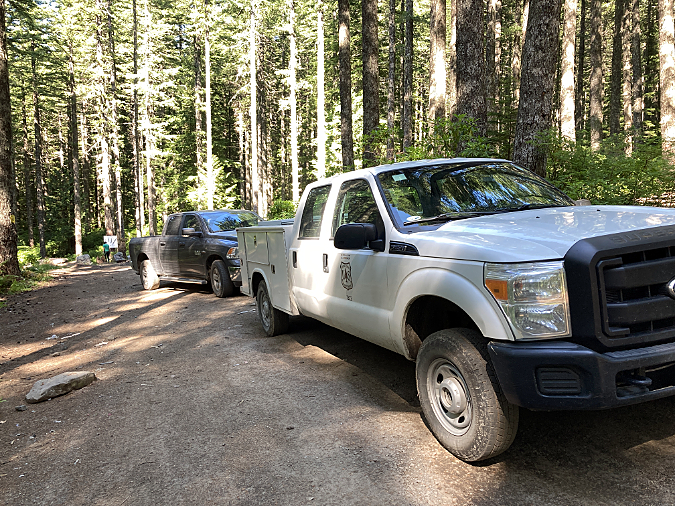
Hikers at the unofficial New McIntyre trailhead on Wildcat Mountain
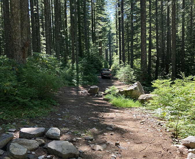
The current and unofficial “New McIntyre” trailhead is simply a turnaround at the end of a short logging spur at the north end of Forest Road 3626. From this turnaround, hikers are able to follow an old skid road a short distance to the McIntyre Ridge Trail, joining it about a mile above of the original trailhead. While not recognized by the Forest Service, this unofficial trailhead is now the de facto access to McIntyre Ridge.
In the beginning (in the late 2000s), this turnaround was lightly visited and made for an excellent and safe parking spot for hikers. The half-mile gravel spur road from Forest Road 3626 was in good condition and easily traveled by passenger cars. This didn’t last long. As private timber corporations began to gate their road network on the lower slopes of Wildcat Mountain, illegal shooting, dumping and off-road activity eventually “discovered” the New McIntyre Trailhead.

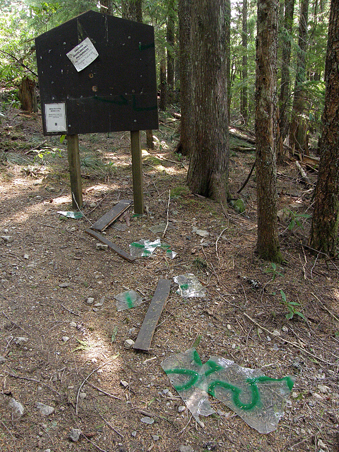
Shooters have “discovered” the New McIntyre trailhead as other shooting galleries on Wildcat Mountain have been closed
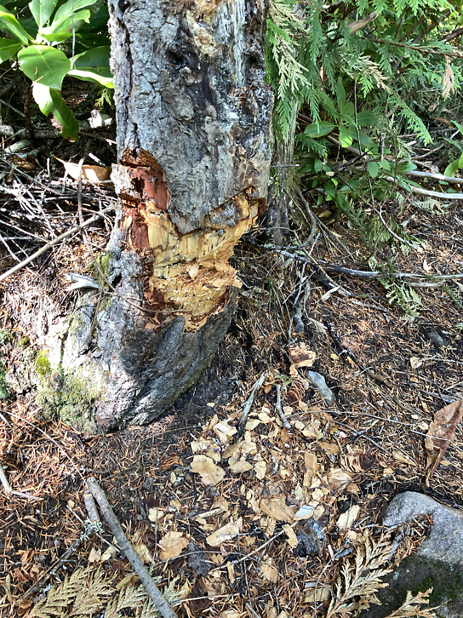
Shooters at the New McIntyre trailhead recently felled two mature trees used as targets and other trees have been seriously injured
This big tree has suffered collateral damage from target shooters at the New McIntyre because it stands just 20 feet behind one of the target trees. Its bark has been seriously compromised by stray gunfire, with pitch bleeding from much of its trunk. If the shooting stopped tomorrow, this tree might survive
Shooters don’t like to be seen. The young men in the pickup disappearing in the distance are making a hasty exit from the New McIntire Trailhead after I showed up and began to unload my hiking gear
The damage is discouraging. Trees are badly scarred by target shooters, with some already toppled by assault. Boulders placed by the Forest Service to keep off-road vehicles out of the wilderness have been vandalized by taggers and the OHVs have simply built a new road into the wilderness that bypasses the barriers. In the center of the turnaround, heaps of half-burned garbage, beer cans and shell casings are routinely scattered around a large bonfire pit. The access road has devolved into a chain of massive mud holes, thanks to OHVs using it as a “play” area.
On a recent visit to the New McIntyre Trailhead, I was pleasantly surprised to find a 2-person Forest Service crew there picking up the place. But without new users coming here to self-enforce this as a lawful recreation area, it will be an endless cat-and-mouse chase for the Forest Service. They simply don’t have the crews needed to heavily patrol Wildcat Mountain to keep up with the mess left behind by shooters and off-roaders.
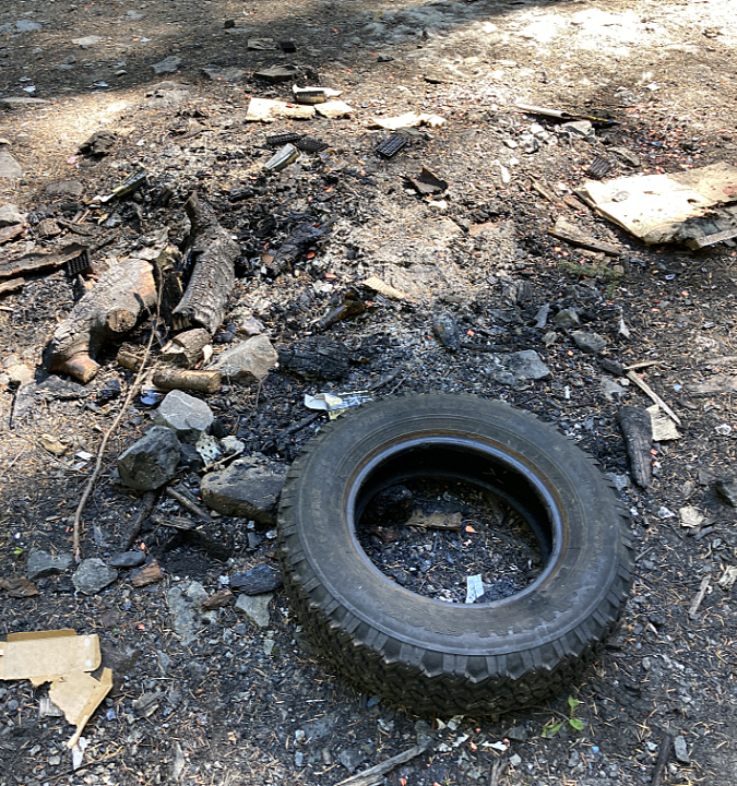
Burned trash left by shooters at the New McIntyre Trailhead
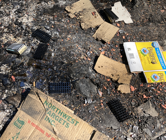
There’s no question who left this burned garbage behind at the New McIntyre Trailhead. Alcohol containers are almost always mixed in with the shooter trash and vandalism
These Forest Service crews arrived at the New McIntyre trailhead on a recent July weekend to clean up after shooters. They reported cleaning up this spot before, along with other illegal shooting sites along Wildcat Mountain Road
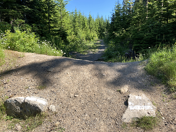
Though the current situation is frustrating, the fix is straightforward. First, the Forest Service should formally recognize the New McIntyre Trailhead as the main access point for the McIntyre Ridge Trailhead. Next, the access road (Forest Road 108) and turnaround should be graded and graveled to improve both the appearance and accessibility for hikers.
Crucially, more barrier boulders should also be added to block the illegal OHV road that bypasses the old barrier. Finally, the tagging and vandalism on the old barrier rocks should be sandblasted from them, as painted messages on rocks only encourages more tagging and shooting.

Off-road vehicle “play” in recent years has turned the short access road to the New McIntyre trailhead into an obstacle course of mud pits and ruts
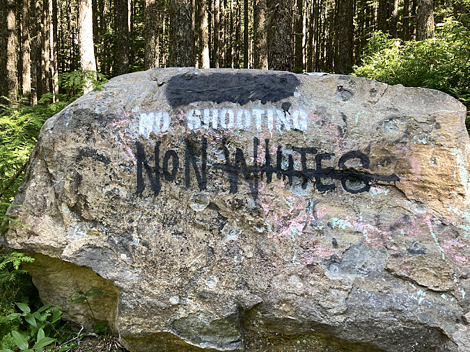
“No Shooting” stencils on the boulders placed around the New McIntyre trailhead were well-intended, by have only drawn more tagging and vandalism
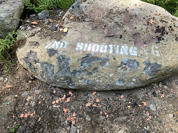
This “No Shooting” stencil at the New McIntyre trailhead has drown gunfire at close range. Combined with empty beer trash scattered about, this spectacle stands as a reminder that today’s shooters are often both reckless and intoxicated, a dangerous combination
Finally, the New McIntyre Trailhead needs signage — a signboard with a map of the Salmon-Huckleberry Wilderness, a trailhead marker pointing to the McIntyre Ridge Trail and a wilderness entry marker that can be seen from the trailhead. Will these be shot up by the shooters? Initially, yes. They probably will. But if enough cars are parked at this trailhead, the shooters and off-roaders will eventually find another place to do their work.
Similar improvements are needed at the nearby Douglas Trailhead, as well. Though it was built less than 10 years ago, the off-roaders and shooters have already had a pretty big impact there, too. Today, the trailhead needs a cosmetic overhaul and the decommissioned road that leads to the old trailhead needs to be decommissioned — again.
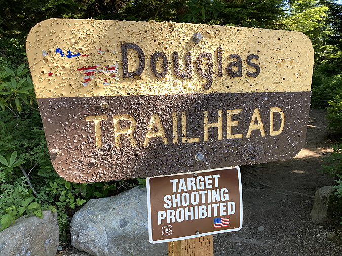
The Douglas Trailhead was relocated a few years ago to reduce the amount of lawlessness, but shooters and off-roaders have continued their assault
This used to be the wilderness entry sign at the Douglas Trailhead, before shooters and vandals tagged the plexiglass sign cover, then shot it to pieces
The Douglas Trailhead used to be located at an old quarry that was a locus of illegal activity and closed off when the new trailhead was built. Off-roaders have since re-opened the road to the quarry and pushed past barriers placed by the forest service to continue their destruction here

This landscape island at the new Douglas Trailhead turnaround has become another OHV “play” feature, with jeeps and ATVs driving right over the top
The goal is simple: the Douglas and New McIntyre trailheads must feel safe and well-maintained for hikers to finally tip the scales on Wildcat Mountain toward lawful, low-impact recreation. This can be done with some modest improvements and some persistence by the Forest Service.
The Roads
The half-mile spur road to the New McIntyre Trailhead is an obvious liability for hikers attempting to visit the area, but Wildcat Mountain Road (Road 36) and Road 3626 both need help, too. The good news is that both are paved and in surprisingly good condition. The bad news is that signage is non-existent, thanks to shooters and other vandalism. This also undermines the sense of safety needed to draw hikers to the area, and it just makes the roads needlessly hard to navigate.
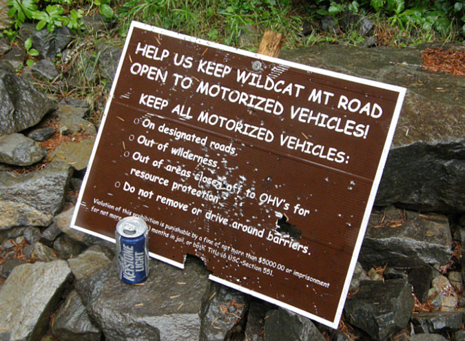
Shooters made a target out of this sign pleading with off-roaders to stay on the road. The obscure third bullet is meaningless, anyway, since the Salmon Huckleberry Wilderness boundary along Road 3626 are not marked
Today, much of Wildcat Mountain Road is already closed to target shooting, but you’d never know it on a summer weekend, when carloads of mostly young men continue to come here to shoot. Signs that once explained what was off-limits and what was still open for shooting have long since been shot to pieces and removed. Even with the signage, the partial closure was confusing and too difficult to enforce.
Instead, it’s time to close the entirety of the Wildcat Mountain Road system to target shooting, including the private timber holdings, since they have already closed their properties. There are plenty of other places for shooters to go, and even lawful target shooting is incompatible with the adjacent Salmon-Huckleberry Wilderness. The folks who live along the lower sections of Wildcat Mountain Road would certainly embrace a no-shooting policy, too, as they also suffer the brunt of lawless activity.

Shooter damage to a sign along Forest Road 2636
This hard-to-find sign buried in the brush along Wildcat Mountain Road (Road 26) is likely seen by none
One tool for enforcing a shooting closure would be to make good use of the steel Forest Service gate on Wildcat Mountain Road near the forest boundary. The gate is located just below the spur road to the Douglas Trailhead, and could simply be closed when the upper slopes of Wildcat Mountain are covered in snow — roughly November through April.

Forest Service gate on Wildcat Mountain Road (Road 26)
Why close the area in winter? It turns out that some of the worst vandalism and OHV use occurs during these months, when few hikers are here to provide eyes on the forest. This may not be a needed as a long-term solution, but it could help change behavior and begin to turn the tide in the near term.
Making it Happen
How can all of this happen? The good news is that it wouldn’t cost much. The Forest Service already has budgets for road maintenance, and repairs to the New McIntyre spur road and turnaround could be prioritized for those funds. Likewise, signage for the trailhead and wayfinding signs along Wildcat Mountain Road and Road 3626 could also be prioritized in existing Forest Service maintenance budgets.
Beargrass meadow in full bloom along the McIntyre Ridge Trail
Closing the area to target shooters? That’s an administrative action that can be done overnight, assuming the Forest Service is willing to make that call. It should be an easy one, as the damage left behind is harming the forest and already costing the agency to patrol and clean up. It’s a case that hiking and trail advocates will need to make in order to move the agency forward.
Designing new trails is often a heavier lift with the Forest Service, as this usually require an environmental analysis, planning and surveying. However, “realigning” an existing trail can often be done without an exhaustive environmental analysis, so the proposals in this article might be less problematic to move forward than a completely new trail.

July Beargrass blooms frame Mount Hood on McIntyre Ridge
Even better, both of the trail realignments proposed here are close to the trailhead and very close to Portland, making them excellent candidates for volunteer organizations like Trailkeepers of Oregon (TKO) to take on as day trips.
Can all of this really happen? The answer is “yes” if the problem statement is “how do we simultaneously improve access to the Salmon-Huckleberry Wilderness while ending lawless behavior in the area.” That’s a compelling and proven strategy. So, let’s take back Wildcat Mountain!
Tom Kloster
August 2020


