Stop Salting the Palmer Glacier!

The plowed surface of the Palmer Glacier shows up on summer evening view of Mount Hood’s south face

A recent article in Willamette Week by Adrienne So goes where The Oregonian and other media have not dared in the nearly 30 years since the controversial Palmer Lift opened the Palmer Glacier to year-round skiing. In her article, So asks the obvious question: is it really such a good idea to pour nearly a million pounds of salt on the glacier each summer to melt the ice for skiers?

But So also asks the more maddening question: how can it be that the Forest Service and Oregon Department of Environmental Quality (DEQ) are fine with this practice? The sad answer lies in the cozy relationship the Forest Service maintains with the ski resorts and the ironic fact that the DEQ can only regulate the salting when damage finally shows up downstream. In other words, when it’s too late.
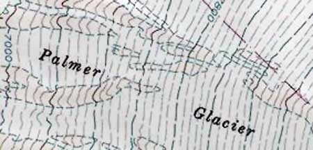
The Palmer Glacier is not the smallest on Mount Hood, but surely the most fragile thanks to its low elevation and southern exposure

What lies downstream from the Palmer Glacier? Initially, a steep maze of alpine canyons carries melt water from the glacier to the tree line. Soon, these mountain streams combine to become the Salmon River. The river flows just a few miles before reaching Red Top Meadows. A short distance beyond, the river enters wilderness and the broad expanse of Salmon River Meadows, by far the largest wetland complex on Mount Hood.

From the meadows, the rapidly growing river turns west, then drops into one of the wildest, deepest canyons in Oregon, thundering over a string of tall waterfalls that are so remote as to have only been discovered in the 1960s. The Salmon River National Recreation Trail follows the canyon section, and is among the most popular hikes in the Pacific Northwest, year-round.

Beyond the steep gorge section, the river slows and broadens, rambling through ancient forests where it is recognized as one of the state’s premier salmon and steelhead habitats. Here, it is strictly managed for its fisheries with special seasons and limits. Trails follow the river in this section, too, leading to shady forest camps and fishing holes. The giant cedar groves along the lower river are the most accessible ancient forest in the region, just 45 minutes from Portland.

For their part, the Timberline operators make a point of never calling the Palmer Glacier by its true name. Instead, they use the term “Palmer Snowfield” in their marketing, apparently to downplay the fact that their summertime skiing is putting one of Mount Hood’s most vulnerable glaciers at risk.
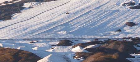
Since the construction of the Palmer Lift, Timberline ski resort operators have plowed the Palmer Glacier like an icy farm field, with the benefit of salt to soften the surface

The motivations of the Timberline resort are easy enough to understand: it’s a commercial venture (albeit on public land and in a public structure), and they are not in the business of protecting the Salmon River ecosystem for the public at large. The salting makes money for the Timberline resort, after all, or they wouldn’t do it.

But to wrap your head around the Forest Service policy of allowing the salting is to believe that dumping just under 500 tons of salt (that’s about 500 pickup loads) on Palmer Glacier each year won’t have an environmental impact. That the impacts could extend from the headwaters of this river complex to the pristine meadows, forests, waterfalls and fisheries that lie below makes the policy that much more appalling.

As destructive and shortsighted as this policy seem, there’s really nothing you and I can do about it – at least not until the salt starts showing up downstream in concentrations that constitute “pollution”. If that seems like a Catch-22, well, that’s because it is.

In the meantime, the only available alternative is awareness. You can start by reading So’s excellent article, over here (PDF):

Salt and a Wound: Summertime and salting is easy on Palmer Glacier

Next, share what you learn with those who love Mount Hood – and especially those who ski at the Timberline resort. It’s likely they don’t even know about this obviously reckless practice, and Timberline hasn’t been particularly up-front about it.

Next, print this bumper (or rear-window) sticker to kick off your own awareness campaign:

Click here for a bumper-sized version to print

There’s a worn adage that when you find yourself at the bottom of a hole, the first thing to do is stop digging. Until more is understood about the impacts of the salting practice on the Palmer Glacier and the sensitive environments that lie downstream, it’s time to stop the salting. Now.
Fire Forests of the Cascades

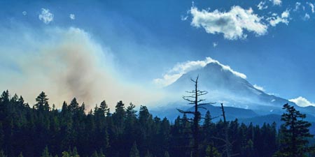
The Gnarl Fire of 2008 shocked Portlanders by racing across the east slopes of Mount Hood, and nearly destroying the historic buildings at Cloud Cap and Tilly Jane. But as an east side fire, the Gnarl burn was relatively small, and part of what has become an annual ritual for rural communities of fighting intense blazes along the east slope of the Cascades.

The 2008 Gnarl Fire, viewed in August from Dufur Mill Road

The 2008 Gnarl Fire, viewed in August from Dufur Mill Road

The cause for the intensity of these fires is well-known and well-documented. We know that a century of fire suppression, promotion of even-aged stands of second growth in logged areas and a changing climate are forces conspiring to burn the east side forests on a scale not seen in recent decades.

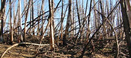
But not all of the east side fires are catastrophic, even with the fuel build-up from our history of fire suppression. The 2006 fire at Bluegrass Ridge was a glimpse into what was once a routine occurrence along the east side of the Cascades. The Bluegrass Fire began as a lightning strike in the dry season, and soon spread along the east face of the ridge in a mosaic pattern: some parts of the forest were completely killed, while others were a mix, where pockets of forest survived among the burned trees.

The aftermath of the 2006 Bluegrass Fire ranged from total destruction in areas like this, to mosaic patterns where less crowded forests existed

The aftermath of the 2006 Bluegrass Fire ranged from total destruction in areas like this, to mosaic patterns where less crowded forests existed

Most significantly, the larger, fire-resistant species like western larch and ponderosa pine often survive fires in these mosaic areas, and this was the case in the Bluegrass Fire. We will know in a year or two whether the extensive larch population in the Gnarl Fire area were similarly resistant.

The survival of these big trees is the key to the natural ecosystem that defines east side forests. Forest ecologists are now calling these east side regimes “fire forests”, as a counterpoint to the west side rain forests, where abundant rainfall is the operative element in defining the forests.

The “fire forest” name is apt, since we now know that a number of tree species in this dry forest system depend on fire for natural succession that creates mature forests. In the Mount Hood area, these east side trees are Douglas fir, western larch and ponderosa pine. All three have thick, fire-resistant bark that helps them survive moderate fires, and benefit from periodic clearing of undergrowth that competes for moisture and soil nutrients. Fires, in turn, release nutrients for the big trees, further enhancing the growth of fire-resistant species.

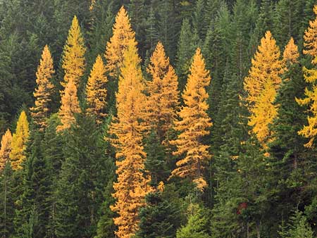
Western larch light up the eastside forests in autumn. Larch are among the fire-resistant species that require periodic burns for their long-term health

Western larch light up the eastside forests in autumn. Larch are among the fire-resistant species that require periodic burns for their long-term health

The question for the east side forest is not whether they will continue to burn — they have evolved with fire, after all — but rather, how we will learn to live with the fires. We now know that we cannot simply extinguish them. A century of fire suppression has created mammoth fires that we simply cannot control.

We also know that we cannot prevent forest fires from starting, since the large majority begin from lighting strikes. And we know that many more catastrophic burns will occur before the east side forests return to a more sustainable condition that mimics the natural ecosystem that once thrived.

Most ominous is the recent discovery — from tree-ring research — that the Western states are coming off an unusually wet century, and that the decades ahead are likely to carry more drought, not less. So it is imperative to help the east side forests stabilize before conditions make that proposition still more difficult.

These mature, healthy forests of western larch, ponderosa pine and Douglas fir along Bluegrass Ridge survived the fire

These mature, healthy forests of western larch, ponderosa pine and Douglas fir along Bluegrass Ridge survived the fire

A first step is continuing to thin tree plantations on logged lands to help prevent still more crowded, bug-infested forests like those that are currently driving the fire epidemic. The second step is more difficult: letting fires burn. This policy will be most difficult in the many areas where rural development has encroached on forest boundaries, but it is a necessary step. Both of these steps will require a new mindset about fire, not the least of which will be a public education shift away from Smokey Bear and fire suppression and toward a modern understanding of fire.

But a third step is most difficult of all: setting fires in prescribed locations to help restore forest balance. While the rash of east side fires in recent years has made this part of restoring forest balance less urgent, it will still be necessary — and controversial. Federal agencies have already begun employing this tool, but in cases where a controlled burn becomes a wildfire, the public is not prepared to understand why that risk is necessary — and perfectly natural. Still more public outreach and education will be needed.

The good news is that the scientists are winning this debate, and even the Forest Service has gradually begun to embrace fire ecology as part of their management philosophy. The Park Service is much further long, having successfully weathered the early criticism of their prescient decision to let the huge Yellowstone fires of the mid-1980s burn.

The remarkable resilience and recovery of Yellowstone in the intervening years has not only been vindication for that bold decision, but also an invaluable lesson to land agencies across the west who are responsible for managing “fire forests”. The time to embrace fires in our forests has arrived.

Boundary Clear Cut – Part Two

The Boundary clear cut consumed this tiny lake. The trees behind mark the wilderness boundary as it rides over the ridges

The Boundary clear cut consumed this tiny lake. The trees behind mark the wilderness boundary as it rides over the ridges

The first part of this article focused on the Forest Service failures that allowed the massive Boundary clear cut to happen on Mount Hood’s northwest shoulder. Now, a look at more of the fallout from the massive clear cut, and opportunities for restoring the area in the future.

First, some numbers. Using a conservative estimate of 100 trees per acre, the 800 acre Boundary complex contained at least 80,000 mature trees, mostly noble fir. Using the Forest Service’s Center for Urban Forest Research models (2002), a conservative estimate for storm water interception of each tree is at least 1,100 gallons per year, or some 88 million gallons of runoff from the Boundary clear cut area, alone. How much additional runoff is that? Enough to nearly fill the 33-story KOIN tower in downtown Portland.

The twin to the logged-over lake, pictured above, this peaceful tarn is located just two hundred yards away, safely inside the wilderness boundary

The twin to the logged-over lake, pictured above, this peaceful tarn is located just two hundred yards away, safely inside the wilderness boundary

Without the forest canopy, the bulk of the rain that falls upon these mountain slopes now runs off, eroding the thin soils, carrying mud and sediments to nearby streams and resulting spikes in stream flows that damage riparian areas and fish habitat. This effect is repeated, of course, across the thousands of clear cuts in the Mount Hood National Forest.

For the Boundary clear cut, the runoff impact is on the heavily logged West Fork Hood River drainage, which is already struggling to recover from the first wave of logging at the turn of the 20th Century (see “Just 75 years” article).

Like other clear cuts, the Boundary cut also triggered edge effects on the uncut forests bordering the timber sale. Because the Boundary clear cut is high elevation, and nearly crests Vista Ridge, these were impacts that timber planners surely could have expected. Yet the timber sale spread close enough to the historic Vista Ridge trail that blowdown triggered by the cut still fall across the trail with regulatory, and unnecessarily. Sadly, this was preventable.

These trees along the Vista Ridge Trail are victims of the Boundary clear cut, having been exposed to high winds by the removal of adjacent forests.

These trees along the Vista Ridge Trail are victims of the Boundary clear cut, having been exposed to high winds by the removal of adjacent forests.

What to do next? For the cut forests of the Boundary complex, the main treatments are road decommissioning and thinning operations in 15-20 years, when the plantations of young trees are likely to become a crowded monoculture.

Just beyond the edge of the Boundary cut, this lofty outcrop provides a stunning view

Just beyond the edge of the Boundary cut, this lofty outcrop provides a stunning view

But from a broader perspective, what about restoring recreation to the area? The Mount Hood National Park campaign calls for converting several roads in the area to single-track bike and horse trails, and adding a campground in proximity to these new trails, and the Vista Ridge trailhead.

There are also opportunities to connect the Vista Ridge trail to the Mazama Trailhead, across Ladd Creek. This new route would provide much-needed loop options that would disperse the heavy hiking traffic that Mount Hood experiences in summer, plus access to the little-known lakes and rocky viewpoints that lie just beyond the destruction zone of the Boundary clear cut.

The key in making this transition is restoration through recreation — bringing visitors back to the area with the express purpose of fostering a public sense of stewardship needed to ensure that a Boundary clear cut never happens again.

Vision Quest Sites

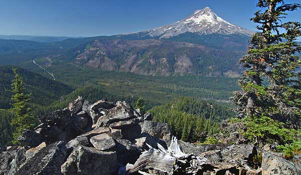
The Lookout Mountain vision quest site is perched high on rocky cliff

The Lookout Mountain vision quest site is perched high on rocky cliff

One of the great thrills of exploring remote mountain tops and rocky outcrops in the Mount Hood backcountry is stumbling upon a long-forgotten vision quest site. These are typically rock pits, large enough for a person — though modern visitors should never enter them, out of respect for both their spiritual and scientific significance.

Archaeologists are still debating the purpose of these pits. The most accepted theory is that these pits were built by Native Americans seeking a vision of their guardian spirit through a combination of physical exertion, deprivation and isolation. Under this theory, Native Americans would have spent several days building these pits, then meditating in them without food or human interaction in order to achieve a spiritual experience.

Other researchers argue that the pits were used as hunting blinds or to store food. But these alternative theories are hard to accept for locations like those around Mount Hood and in the Gorge. Most of this sites are on huge talus slopes or mountain tops, which would have been inconvenient as a food cache or for retrieving killed game.

The Lookout Mountain vision quest pit pictured here has still more mystery surrounding it. While the location of the pit is typical – high on a rocky knoll, overlooking the East Fork valley and Mount Hood – the walls of the pit are stacked higher and narrower than most, possibly due to the steepness of the site.

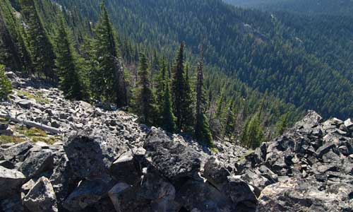
Looking down the steep slopes of Lookout Mountain from the vision quest pit

Looking down the steep slopes of Lookout Mountain from the vision quest pit

But even more perplexing are the worn traces of mortar between some of the stones (seen in the wall of the pit, toward the bottom of the second image). One possibility is that the mortar was an early attempt to preserve the site, given it’s fragile and exposed state. But who would have hauled both mortar and water to this site?

Perhaps early forest rangers who once manned a Forest Service guard station at High Prairie, a short distance away. The guard station was abandoned half a century ago, so this timing would be consistent with other, early 20th Century effort to “restore” Native American structures. This was famously done at several spots in Pueblo country, but might have happened here, too.

Whatever the answer, the Lookout Mountain vision quest site is among the most inspiring in the area, and it’s easy to imagine Native Americans seeking out spots like this for a spiritual journey. But it’s also easy to imagine sites like this being lost forever, for lack of a management imperative by the U.S. Forest Service to actively protect these places.

This kind of fragile resource is also among the best arguments for the Mount Hood National Park Campaign, since the Park Service has a long and proven track record of this sort of resource protection. In contrast, the Forest Service has aggressively logged much of the terrain around this site, oblivious to special places like this. So for now, obscurity is the best friend of these resources, until better stewardship finally comes to Mount Hood.

We have to choose?

Crown Point from Women's Forum State Park - a threatened view?

Crown Point from Women's Forum State Park - a threatened view?

According to the Columbia Gorge Commission website, the Vital Signs Indicators Project is “identifying several measures to assess changes in the scenic quality of the Gorge over time.” Translated, this means that the Gorge Commission has set up a web survey to poll the most popular Gorge vistas among the traveling public. The survey allows “up to three” favorite vistas for each of Interstate 84, Highway 14 and the Historic Columbia River Highway.

Wait..! Just three? Do we really have to choose? Well, yes. And according to the Commission, “the views with the most votes for each roadway will be included in the list of key Gorge views that will be monitored in the future by the Commission.” So, your votes matter, at least for this effort. The good news is that this project is intended to help the Commission cope with man-made eyesores that mar scenic vistas, as well as “vegetation management”, so that views like the classic scene from Women’s Forum Park (above) aren’t blocked over time.

Thus, hard as it might be to choose, you should take a moment to visit their website and take the survey. It will take you 10 minutes, or so, and you’ll be helping the Gorge in a small way. The survey runs through December 5, 2008, and after that, you’ll have to settle for reading the results. Here’s the link to the Gorge Commission website.