It’s Time for Safe Stream Crossings on the Timberline Trail

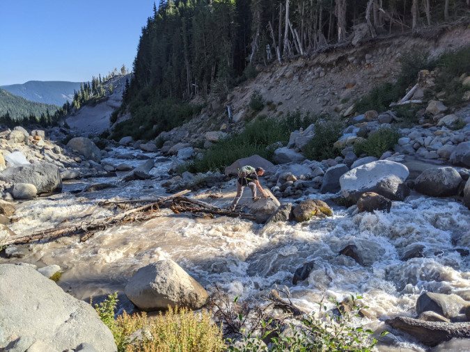
Hiker making a scary bridgeless crossing of raging Newton Creek along the Timberline Trail during summer runoff in 2022 (Craig Gwydir)

In this previous article, the story of Sarah Bishop included a call for restoring a footbridge over the Sandy River along the popular Ramona Falls loop trail. After her tragic death, Sarah’s family led a successful campaign to install signs at several wilderness entry points around the mountain warning hikers of the risks in crossing glacial streams and how to navigate them safely.

That was 20 years ago, and the situation has since grown urgent. The time has now come to simply provide bridges at the fourteen glacial stream crossings within the Mount Hood Wilderness. Why are the crossings so much worse? Here are the driving forces making the current situation unacceptable and now the moment to do something about it:

1. Sheer numbers of hikers: in one of their classic 1970s field guides, iconic authors Harvey Manning and Ira Spring once described the Mount Hood Wilderness as “mobbed year-round”. Both passed away in the early 2000s, and they probably couldn’t have imagined what “mobbed” really looks like, as what they saw as mobs the 1970s would be dwarfed by today’s crowds. The explosive growth in public demand for wilderness trails around Mount Hood translates not only to overflowing trailhead parking, but also traffic jams at the mountain’s most notorious glacial stream crossings, where hikers often wait in line to navigate sketchy logs or user-rigged “bridges” to cross.
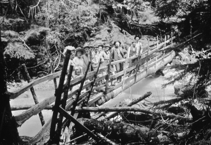
Crossing Mount Hood’s glacial streams has always been a challenge for hikers. Rails were added to a fallen log to create this bridge over the Zigzag River in the 1920s (Gary Randall)

Hikers are also less prepared for these obstacles today, thanks to social media driving the demand. Where hikers of the 1970s might have read one of the Spring & Manning or Don and Roberta Lowe guides to plan their trip, and thus become aware of these obstacles, today’s hikers are far more likely to have planned their trips based on a random Instagram image or Tik Tok videos that rarely bother to include meaningful trail information.

2. The glacial streams are a ‘changin: If you’re an old-timer, you probably remember when footbridges crossed several of the big streams on Mount Hood. That was a time when global warming was still a theory and glacial retreat was barely perceptible (though it was already underway), allowing for permanent structures at several crossings. Today, we can see the glaciers changing every year, and their retreat has wreaked havoc at downstream crossings. 
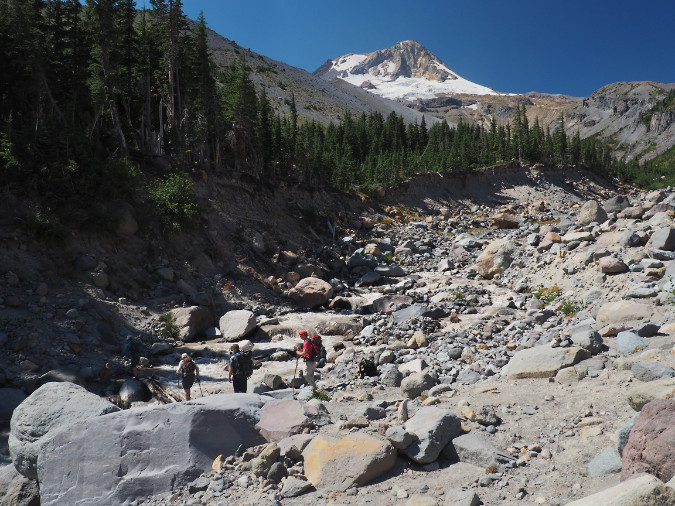
The Newton Creek crossing on the Timberline Trail is nearly 30 feet lower than it was just two decades ago, thanks to a series of floods and intense stream erosion resulting from climate change

As the ice melts away, U-shaped glacial valleys are rapidly eroding and deepening to become V-shaped river canyons. New channels are continually forming downstream from the glaciers as heavy loads of debris from upstream erosion are released into glacial streams. Winter debris flows and summer flash floods have also become a routine event on the mountain, presenting a volatile, continually changing landscape.

3. Hiker safety: Mount Hood is increasingly an urban wilderness dominated by day-hikers, less experienced hikers, families with young kids and some people with disabilities. This is to be expected — the mountain is just an hour away for some 2 million people – more than four times the population living in greater Portland in the 1930s, when the Timberline Trail was originally constructed. 

Like it or not, these numbers will only continue to grow, in part because our unique quality of life – including a mountain in our collective backyard — continues to bring people to our region. So, given this reality, will our mountain be a wilderness for everyone, or just those who are physically able to wade a torrent of thigh-deep glacial runoff or inch across a wobbly log six feet above the water?
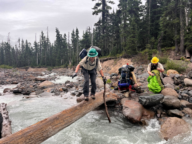
Volunteers from Trailkeepers of Oregon (TKO) making a sketchy crossing of Newton Creek enroute to a multi-day wilderness stewardship event within the Mount Hood Wilderness. Among their gear are 7-foot manual crosscut saws – the only saws allowed for clearing trails within the wilderness.

The hazards presented by the glacial crossing affect more than just hikers. Trail crews, backcountry rangers and emergency responders carrying heavy gear are also forced to navigate these obstacles – sometimes to rescue folks injured while making the same dangerous crossings.

4. Quality of the (urban) wilderness experience: People go to the Mount Hood Wilderness for the exceptional alpine scenery and a reasonably rugged experience. For most, this simply means an unpaved mountain trail, not confronting scary obstacles that leave them shaken and reluctant to return. 
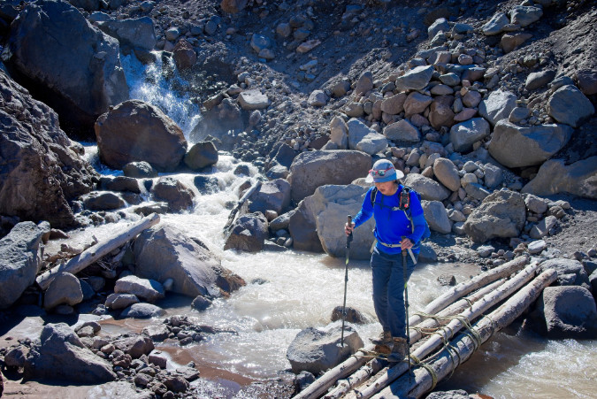
Timberline Trail hiker crossing a user-rigged log crossing on the notorious Eliot Branch in 2023, the volatile outflow from Mount Hood’s largest glacier (Guy Meacham)

There are wilderness purists who argue that it should be this way, and those unable to handle the risks should simply stay away. It’s an elitist argument that – unfortunately – is also made by some of our land managers as an excuse to do nothing. Fact is, Mount Hood is an urban wilderness (see No. 1, above), not the Alaskan frontier. For elite hikers seeking physical danger and hardship in their outdoor experience, there are dozens of wilderness areas beyond the day-trip range of major urban areas like Portland to choose from. Mount Hood just isn’t one of those places, and it never really was.

5. It’s good for business: Just as many people from our area think Mount Hood is already a national park (really!), so do visitors from around the country — and the world. The Timberline Trail brings untold numbers of long-distance travelers to the area every year, most thinking they will enjoy a national park-like quality experience on their 40-mile circuit. Over the years, I’ve encountered many of these folks on the trail and have been saddened to hear of their disappointment – not with the spectacular scenery, which they marvel at – but of the deteriorating trail conditions and especially the stream crossings. 
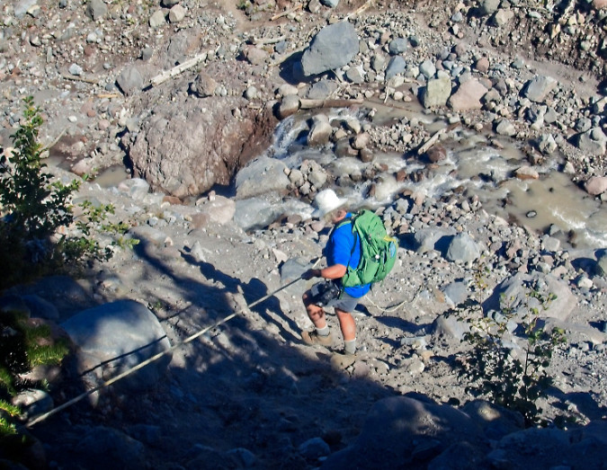
Hikers from around the world come to Mount Hood to experience the Timberline Trail, only to find themselves descending on random ropes left by previous hikers to navigate scary, bridgeless stream crossings (Chiyoko Meacham)

Why does this matter? Because visitors from out of state or other countries are the folks most supporting the tourism economy in the communities surrounding the mountain, from lodging and restaurants to local guide services, museums, galleries and farm stands. Yet, the quality of the Timberline Trail experience is rarely appreciated for its benefit to the local economy. Visitors from elsewhere are essential to any local tourism strategy, but with the current state of the trail, we are doing our very best to discourage positive experiences and repeat visits from beyond Oregon and Southwest Washington.

6. Real funding options: Did you know the Forest Service issues special use permits to private, for-profit businesses to maintain many of our campgrounds and trailheads, and even to conduct private trail events on Mount Hood each year? More significantly, this includes the large ski resorts who operate on our public lands under special permit, and who are increasingly marketing themselves as hiking destinations. Should these commercial interests be part of funding needed trail improvements on the Timberline Trail – including stream crossings? Absolutely. More about that toward the end of this article.


7. No more legal excuses: On December 27, 2021, the U.S. Court of Appeals ruled in the Ludwig vs. the United States case that the U.S. Forest Service was immune from wrongful death liability after a hiker drowned while attempting to cross a footbridge over the Sandy River near Ramona Falls during an extreme storm event. 
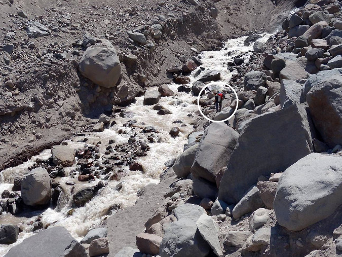
Can you see the hikers (circled) contemplating a ford of the Eliot Branch – and perhaps giant boulders teetering above the stream? Nobody should face this degree of physical risk when hiking the Timberline Trail (Robin Barklis/Portland Hikers)

The Ludwig case has long been pointed to as the reason for not providing safe crossings there, or anywhere within the Mount Hood Wilderness, but the case has since been decided. Now, it’s simply an excuse for doing nothing – though, ironically, it’s conceivable that not doing anything could open the agency to some future liability claim for exactly that reason. 

It’s time to move beyond legal liability excuses and simply make public safety the priority, once again. It’s time to finally make the Timberline Trail a safe, world-class experience for everyone.

Fifteen Crossings?

So, where are the footbridges needed? At all fifteen glacial stream crossings within the Mount Hood Wilderness. All of them – though more on how to tackle that in a bit. Here they are in the traditional clockwise order that hikers experience, beginning at Timberline Lodge, each scored according to their relative fear-inducing capacity:
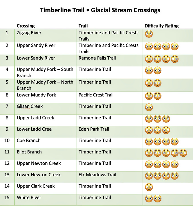
[click here for a large version of the table in a new window]

Here’s a map of the proposed glacial stream footbridges. Most are located along the Timberline Trail (and the Pacific Crest Trail where the two overlap), along with two popular alternate routes to the Timberline Trail at Eden Park and Elk Meadows and the major access point to the loop at Ramona Falls:

[click here for a large version of the map in a new window]

What do the worried emoji ratings mean? They are subjective based on my own hiking experiences over the years, along with those of many others in my hiking circles. They range from a ranking of one emoji (rock hop, usually with dry feet) to four or five emojis for scary crossings in fast, icy, thigh-deep water that even the most experienced hikers struggle to cross during the summer peak glacial melt. 

It’s no surprise that the Eliot Branch should rise to the top of the list, as it is fed by Mount Hood’s largest glacier and has experienced some of the most dramatic erosion and canyon deepening on the mountain in recent years. In contrast, the Zigzag River, Glisan Creek and Upper Clark Creek crossings are not major obstacles for most hikers. However, any of these have the potential to be dangerous during summer glacial outbursts and thunderstorms, as was the case for Sarah Bishop. 

Going by the book..?

What is the official line from the Forest Service on providing stream crossing structures? It’s fairly specific. Here’s what the Forest Service trail handbook has to say:

______________ 

“Stream and river crossings present a challenge to trail managers who need to balance difficulty levels, safety, convenience, cost, environmental consequences, and esthetics. At one end of the use spectrum, a bridge can allow people with disabilities, toddlers, and users who are new to the outdoors to experience the trail with little risk.

“But bridges are expensive. Wilderness visitors who expect a challenge may prefer a shallow stream ford. During high water, these folks may opt for a tightrope walk across a fallen log. Each kind of water crossing has consequences for the recreation experience and the lands being accessed. Choose wisely from the spectrum of options before committing present and future resources to any given crossing.”

______________ 

The key in this guidance is the focus on the spectrum of user abilities. “Wilderness visitors” are implied to be at the most experienced end of the spectrum, and assumes these hikers are both aware of the meaning of designated wilderness and are either seeking — or at least expecting – to ford streams on their own. 

The sturdy Clark Creek Bridge is a bit of a relic from days when the Forest Service actively provided bridges around Mount Hood. It’s a permanent bridge that has survived for years, thanks to Clark Creek being the less rambunctious outflow from the Newton Clark Glacier to its rowdy twin Newton Creek. Today, it is the only bridged glacial stream crossing on the mountain. Clark Creek forms the Mount Hood Wilderness boundary, here – the wilderness entry sign is on the opposite end of this bridge.

This is almost never the case on Mount Hood. How to know that? Just look at the footwear (sneakers and flip-flops) and lack of trail safety basics on many of the folks heading into the wilderness, often without even a pack or bottle of water, much less a map or knowledge of the trail. All too often, ill-equipped hikers also have young kids and pets in tow.

The key wording from the Forest Service guidance on this less experienced end of the user spectrum should apply to all of Mount Hood’s glacial stream crossings: “a bridge can allow people with disabilities, toddlers, and users who are new to the outdoors to experience the trail with little risk” (author’s underscored emphasis added).

What is the Minimum Tool Philosophy?

There’s more guidance from the Forest Service best practices on footbridges that comes from the “minimum tool philosophy”, which seeks to “get the job done with the least long-term impact while still meeting management objectives”.  That’s a mouthful, but here are the considerations included in this part of the agency technical guidance:

  1. Do we really need a bridge here? Do we really need to cross here early in the spring? 
  2. Will someone be killed or injured if we don’t provide an easier crossing?
  3. Is this really the best place to cross this stream?
  4. What alternatives do we have to cross this stream, including not crossing it at all? Can we afford this crossing?
  5. What are the environmental and social consequences of a given type of crossing here? Can we commit to long-term inspections and maintenance?
  6. Who will really care if we don’t build (or replace) a bridge?

A telling footnote in this section of the Forest Service guidance adds that “it’s a wonderful thing to keep one’s feet dry, but keeping those feet dry in the backcountry is expensive.” For me, this comes across as surprisingly dismissive and elitist, but the list of “minimum tool” considerations are nonetheless easy enough to address in the example of the Timberline Trail.

The first two questions answer themselves – we already know many of the crossings on Mount Hood are dangerous, but also that travel is highly seasonal. The third, fourth and fifth questions also answer themselves: the Timberline Trail is an iconic feature that can’t simply be closed for lack of a desire or funding by the agency to make it safe to travel. It’s the Timberline Trail, after all! People come from around the world to experience this historic trail. Enough said.
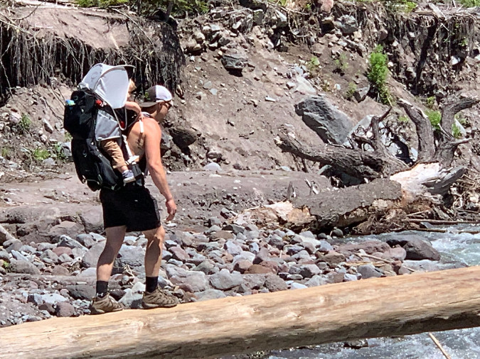
Yikes! Hiker forced to carry a toddler over a very high log crossing over the Lower Sandy River in 2022 (TKO)


The final question seems obvious, but it does go to the larger problem that the Timberline Trail isn’t actively championed by anyone beyond the hiking community. But would anyone other than hikers “really care” if the bridge problem remains unresolved? No doubt, though the economic value of trails is almost never featured in local tourism programs, and thus not really understood by the broader community. 

The two counties that encompass most of Mount Hood – Clackamas and Hood River – market themselves heavily at tourism destinations, yet have minimal content on their tourism websites for Timberline Trail visitors beyond a link to the Forest Service web page for the trail, which currently opens with this grim warning:
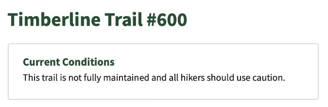
Makes you proud to be an Oregonian, right?

Be they local day hikers or international travelers coming to experience the Timberline Trail, all visitors to the mountain should obviously be part of the local tourism strategy. That’s a bigger nut to crack, but a good start would be making the trail safe so that disclaimers like this aren’t the first thing a prospective visitor sees when planning a trip to our mountain.

What are some working examples?

When it comes to suffering the effects of rapid climate change on its streams, Mount Hood has plenty of company from glacial peaks around the world. The best peers to learn from are right here in the Pacific Northwest, where trails on the other big Cascade volcanoes are also being impacted by the same forces we’re seeing on Mount Hood. There are also great regional examples of bridge structures provided within designated wilderness — including within the Mount Hood National Forest!

As around-the-mountain trails go, Mount Rainier’s Wonderland Trail is the Timberline Trail writ large. The trail covers 93 miles compared to Mount Hood’s 40-mile loop, and Mount Rainier has 28 glaciers compared to Mount Hood’s 12, several of them dwarfing the size of Mount Hood’s largest glaciers – and similarly outsized glacial streams, as well.
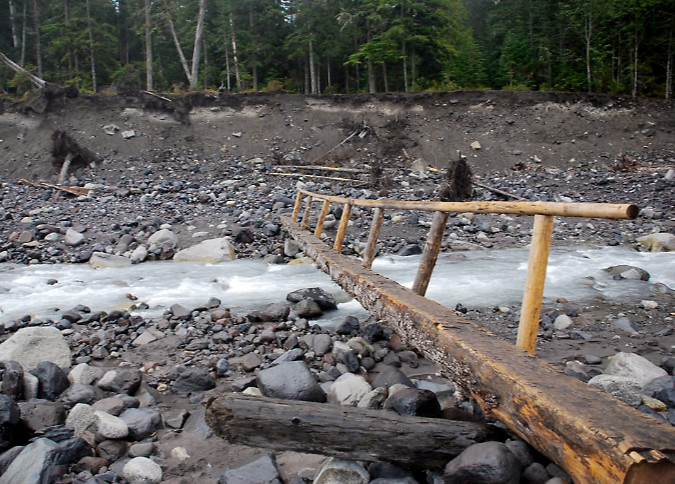
Carbon River Bridge, Mount Rainier National Park. This simple design is the most common in the park. It can be repositioned when needed, and easily replaced if lost to a major flood event (NPS)

Mount Rainer is protected as a national park, of course, and the Park Service strictly manages the Wonderland Trail as a pristine wilderness experience. Though it’s an ongoing struggle, park rangers work to provide seasonal crossings on the major glacial streams throughout the hiking season, though they do wash out frequently, leaving hikers to navigate on their own until the bridges can be re-installed.
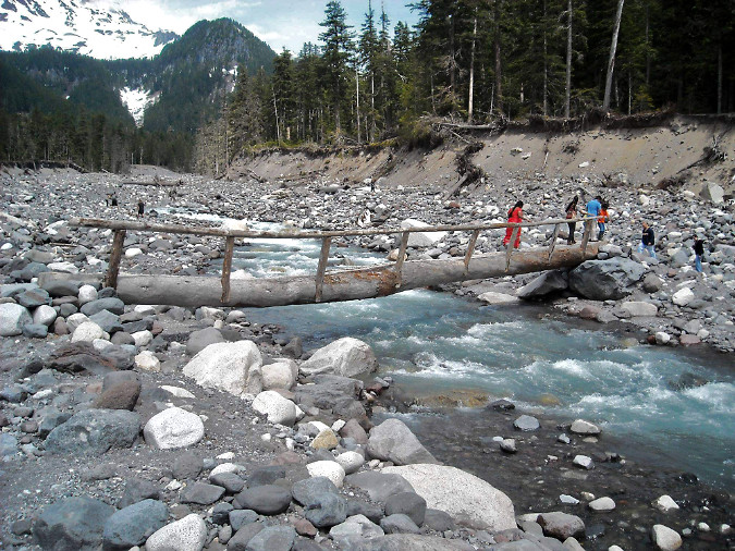
Nisqually River Bridge, Mount Rainier National Park (NPS)
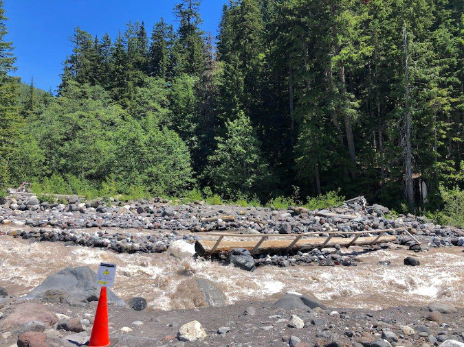
Nisqually River Bridge temporarily out of service due to shifting river channels. The sign on the cone in the foreground cautions hikers on the best way to navigate the crossing in the meantime (NPS)

The Park Service at Mount Rainier has coped with this challenge with much less formal crossings, often simply a long, locally-sourced log with a single handrail that can be sacrificed should (or rather, when) the next flood sweeps down from the glaciers above. Hikers are cautioned to prepare for occasional washouts and difficult crossings each year, though the management goal is to make this classic trail as safe and enjoyable as possible. The park web page for the trail also includes extensive detail on current conditions, backcountry regulations and tips for planning a trip that would be a great template for expanding web content for the Timberline Trail.

Heading north to Mount Baker, the Forest Service has provided a decidedly industrial, aluminum seasonal bridge in the past at Rocky Creek (below), a glacial outflow within the Mount Baker National Recreation Area. Though the design would not be appropriate for a wilderness setting, the seasonal placement is a helpful guide, as this stream is much like Mount Hood’s larger glacial outflows.
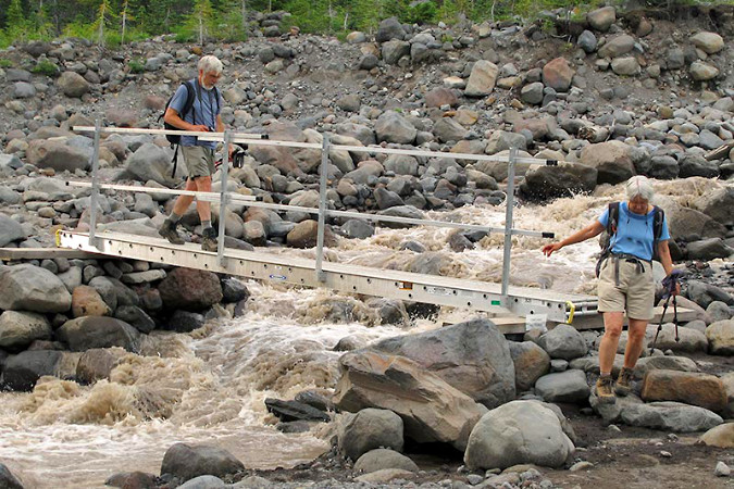
Rocky Creek Bridge, Mount Baker National Recreation Area (Adam Schneider)

At Olympic National Park the newly built, permanent crossing of the Soleduck River (below) is a handsome solution that could work at downstream locations like the lower Muddy Fork on Mount Hood, where the river channel is less volatile and a large bridge could connect relatively stable, forested banks like these. While the Olympic peaks along the High Divide that feed into the Soleduck no longer have active glaciers, they do have an impressive snowpack each winter and famously heavy precipitation that required this bridge to be built for regular stream flooding.
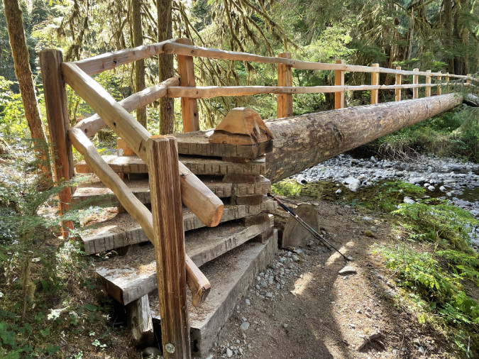
The beautifully constructed Soleduck River Bridge in Olympic National Park (Tom Lovett)

Turning south and back to Oregon, the Fall Creek Bridge (below) in the Three Sisters Wilderness is another fairly new example of a permanent bridge on a heavily traveled wilderness trail. Though it does span a glacial outflow from the South Sister’s Lewis Glacier, the volatility of the meltwater is greatly reduced by the Green Lakes, which act as a jumbo settling pond for the silty glacial runoff. This is why Fall Creek is both crystal clear and fairly stable within its banks downstream from the lakes, and why a permanent bridge design could be constructed here. Like the Soleduck River example, this structure could be a model for the lower Muddy Fork, where a permanent bridge seems feasible. 

Fall Creek bridge near one of the main gateways into the Three Sisters Wilderness

Contrary to what you may have heard, the Mount Hood National Forest has recently built (or rebuilt) several footbridges within its designated wilderness areas. One example described in [the previous article on the subject] is the lower Ramona Creek footbridge, built within the wilderness just a few years ago, and just a short distance from the Lower Sandy River crossing. The justification here (and for the upper Ramona Creek bridge at the base of the falls) is simply the number of hikers on this very popular trail – a decision completely consistent with the Forest Service best practices.

A lesser-known example is this footbridge built over Gumjuwac Creek (below), in the heart of the Badger Creek Wilderness, just east of Mount Hood. Where Ramona Creek is relatively small, Gumjuwac Creek can be a seasonal challenge during spring runoff, and thus the decision to build this new structure a few years ago. Much of the Badger Creek Wilderness has burned in recent days as part of the ongoing Grasshopper Fire, so we don’t know the fate of this bridge at this time.
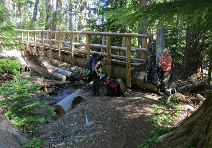
Gumjuwac Creek Bridge in the Badger Creek Wilderness (TKO)

Meanwhile, in the Mark O. Hatfield Wilderness in the Columbia River Gorge National Scenic Area, volunteers recently rebuilt this bridge along the Wahclella Falls trail, along with other structures affected by the 2017 Eagle Creek Fire. Like the examples from Ramona Falls and Falls Creek in the Three Sisters Wilderness, the decision to build permanent structures here is in recognition of the heavy trail use, again, consistent with Forest Service guidelines. 
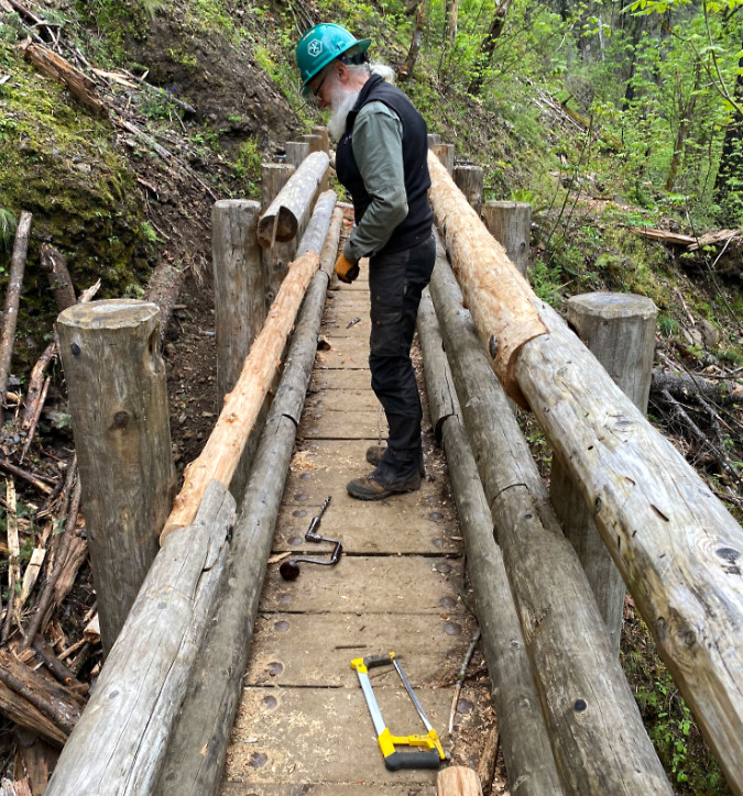
Trailkeepers of Oregon (TKO) volunteer repairing a winter-damaged bridge within the Mark O. Hatfield Wilderness (TKO)

These permanent bridge examples are included to debunk the idea that bridges along the Timberline Trail are somehow precluded by the Mount Hood Wilderness designation. It’s simply not the case, though it is true that permanent bridges on several of Mount Hood’s glacial streams would soon be washed away. So, what would a simple, straightforward and affordable solution for these crossings look like?

Read on…

A simple proposal for Mount Hood… hiding in plain sight?

It was plain sight — but a while ago. In their response to the 2008 Bluegrass Fire on the east edge of the Mount Hood Wilderness, fire crews were dispatched from the Elk Meadows trailhead. Crossing Clark Creek was simple, as the permanent bridge shown above was there and ready to serve the hundreds of firefighters who eventually descended on the blaze. 

Crossing Newton Creek was another matter. There was no bridge and the stream is well known for its year-round volatility. In the urgency of the moment, necessity made for the simplest, most elegant and affordable solution possible. Using logs washed left along the floodway by the stream, firefighters simply cut them into manageable sections, then halved them down the center to make simple bridge spans. Smaller logs were cut and shaped with hand tools to form simple abutments. The designs were straight out of 1930s era Civilian Conservation Corps handbooks for backcountry engineering. 
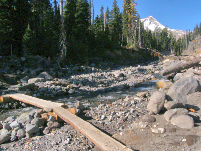
Seasonal crossing at lower Newton Creek built by firefighters to provide access to the 2008 Bluegrass Fire
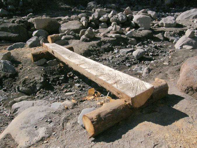
The simple design at Newton Creek allowed the crossings to be moved or adjusted with the ever-changing channels of Newton Creek as the fire operation progressed over several weeks

These designs were also the most compatible with their wilderness setting. There were no nails, no rock baskets and no concrete footings, just wood. They were also highly adaptive, with crews able to quickly move sections around to keep up with the ever-changing channels formed by Newton Creek during the summer runoff season. They could also be easily set back in place if the high water in the stream dislodged them. These simple crossings lasted through the fire, the following winter and into the next summer season, serving hikers long after the Bluegrass Fire had burned out. 

Within a couple years, the logs crossing Newton Creek were eventually swept away and added to the many logjams downstream on this very rowdy glacial stream. Therein lies the beauty of this solution: it doesn’t matter. The logs were untreated and used no hardware in their installation, making them nearly indistinguishable from other logs piled along the stream. Yet, they still provided safe crossings for hikers who otherwise would have been wading the stream, or scrambling over loose logs, unsafe logs.
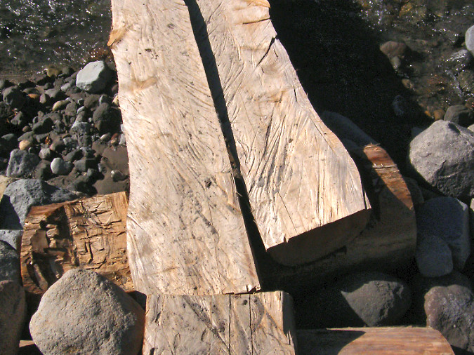
Detailed view of logs halved with chainsaws and cupped footings created with chainsaws and hatchets

These simple structures could be used on any of the fifteen glacial stream crossings in the Mount Hood Wilderness, including every one of the crossings on the Timberline Trail. The design is simple, adaptive, cheap and renewable. 

The main constraint in the design for a wilderness setting is halving the logs, as this work was done with chainsaws during the Bluegrass Fire operation. Could logs simply be halved with crosscut saws? It’s possible, but time-consuming and impractical. Besides, volunteer organizations like Trailkeepers of Oregon (TKO) and others are already very busy just clearing fallen logs from our trails inside the wilderness that cross recent burns.
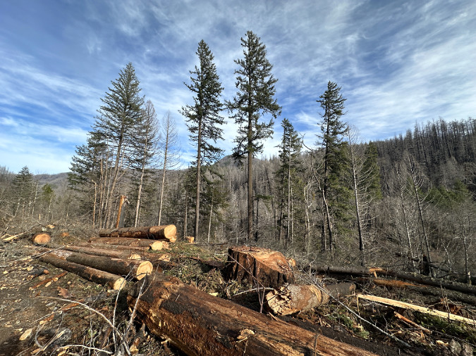
Logs stacked near Indian Henry Campground on the Clackamas River after the 2020 Riverside Fire

So, why were power saws allowed inside the Mount Hood Wilderness area in 2008? Because wilderness limitations on machinery are typically lifted during firefighting efforts, and it turns out these exceptions fall under the same provisions that allow the Forest Service to construct wilderness footbridges where needed to “protect the health and safety of persons within the area”.

Does that mean an exception could be made now for the purpose of constructing wilderness trail bridges? Unlikely. Short of a forest fire, lifting limits on the use of chainsaws in wilderness for any purpose remains controversial, even when a good case could be made for protecting the health and safety of the public. Therefore, this proposal calls for mass production of the half-log spans off-site, then transporting and caching stockpiles of 3-4 logs at each of the crossings, ready to install as needed.

How would this work for all of the glacial stream crossings in the Mount Hood Wilderness (except for the lower Muddy Fork crossing on the Pacific Crest Trail – more on that in a moment):

1) Prepare standardized materials offsite: Halved logs would be prepared offsite in stockpiled in standard 8-foot and 12-foot lengths. The Forest Service has a bounty of fire-killed logs at the moment in the Clackamas District, thanks to the 2020 Riverside Fire and subsequent blowdown events. These could provide decades of material for this purpose, and it’s work that could be done by contractors or volunteers as part of chainsaw certification programs that already take place there.

Logs stacked along the Clackamas River Highway after the December 2025 storms

2) Drop log caches: Caches of logs would be placed near 14 seasonal crossings – enough for three replacements and close enough to the crossing site to be moved into place by Forest Service or volunteer crews. The main lift (pun not intended!) in this step would be moving the log caches to the various sites, as it would require the Forest Service to make an exception to the Wilderness Act to bring helicopters in. This sounds harder than it is. Going back to the Wilderness Act, there are two important exceptions for using motorized equipment in wilderness for administrative purposes: 

1) In emergencies involving the health and safety of persons within the area.

This is the provision that allowed for construction of the Newton Creek bridges during the Bluegrass Fire.

2) When a motorized or mechanized action is necessary as the minimum requirement for proper protection and administration of the area as wilderness.

This second exception clearly seems to apply, since trails themselves are core the Wilderness Act which states that “…wilderness areas shall be devoted to the public purposes of recreational, scenic, scientific, educational, conservation, and historical use”, and thus the administrative purpose. Helicopters would likely be less controversial than chainsaws, as the work could be done in as little as a single day and would not involve power equipment on the ground.

Helicopters used for logging can carry multiple, full-length logs per load (US Forest Service)

How would this work? Having photographed helicopter logging (from a safe distance) in the past, I’ve watched hundreds of logs moved in bundles of 2-6 raw logs measuring 30-50 feet in length over the course of a couple days. Dropping the caches of half-logs would only have to be done every few years, thus further minimizing impact on the wilderness. If the drops were timed for late fall, there would be minimal conflict with hikers, while still allowing ground crews to access the different stockpiling sites.

But does the Forest Service even own helicopters? Only a few, though the agency contracts or charters with dozens of private providers to carry out a host of forest management activities, so this work is easily within their wheelhouse of know-how and funding arrangements.

3) Seasonal bridge placement: while there’s no harm to the environment if a half-log bridge is swept downstream, the idea is to minimize that risk and reduce the need to replenish the cache at a particular site by placing them as seasonal crossings. A reasonable window could be from July 1 through October 31, the mostly snow-free season when the vast majority of hikers are entering the wilderness. Hikers attempting to cross the streams before or after that time would at least be aware of the lack of structured crossings. 
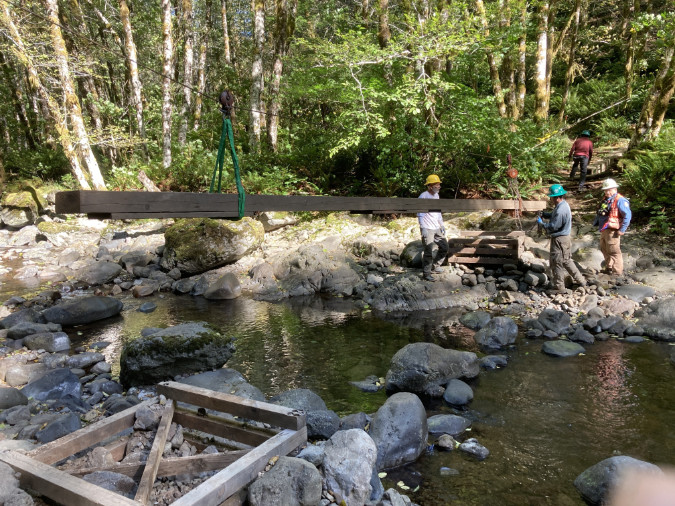
Trailkeepers of Oregon (TKO) volunteers work with the Oregon Department of Forestry to annually install and remove this seasonal bridge at Elk Creek on the popular Kings Mountain Trail

While the placement could be done by Forest Service crews, there are also at least two trail stewardship non-profits – Trailkeepers of Oregon (TKO) and the Pacific Crest Trail Association (PCTA) — that have the volunteer capacity, expertise and working relationship with the Forest Service to be part of placing these structures.

The Forest Service would need to periodically replenish the log caches at each site as logs are lost or damaged, though the idea of a cache is to minimize this need by providing enough material onsite to last for years. The abutment sections would be completely constructed onsite using manual tools, so only the half-log spans would be cached. The simplicity of the design would also allow backcountry Forest Service or volunteer crews to quickly reinstall or replace crossings that are impacted by flooding or channel changes during the summer hiking season.

Where to start?

Yes, this is a big proposal, given the status quo of doing nothing. Where to start? Following the informal “fear emoji” rating in the prior table, the three most problematic among the 15 glacial stream crossings are the upper and lower Sandy River crossings and the Eliot Branch. 
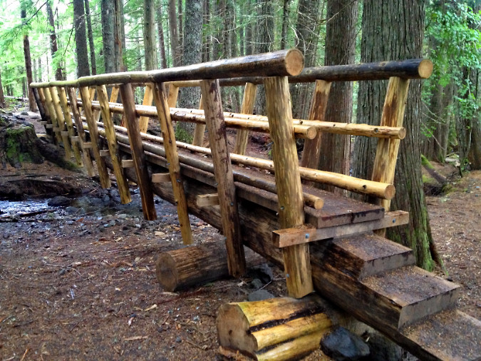
The Forest Service built this wilderness bridge on the Ramona Falls Trail – but how were materials delivered to the site?

All three of these sites could provide excellent pilot projects, not just because safe crossings are badly needed here, but also because they are close to trailheads. This could allow materials to be transported to the site without machinery, thus avoiding the complexity of helicopter drops in a pilot phase (pun also unintended!). They would also be easily accessible for volunteers to monitor and maintain. If these pilot projects are successful, then the program could gradually be expanding to the rest of the wilderness.

So, how did the Forest Service bring materials to the new Ramona Falls trail bridge that was constructed in 2012? Unclear, as the structure includes both logs that might have been sourced locally, but also dimensional lumber that must have been carried in. This somewhat recent project could provide guidance for a new seasonal bridge pilot project on the nearby Sandy River crossings. 

There’s a notable exception in the list of 15 crossings, and it was mentioned in the permanent bridge examples from Olympic National Park and the Three Sisters Wilderness: the lower Muddy Fork crossing. For years, a very large log (shown above) has been in place at the crossing, serving as a “permanent” bridge of sorts for hikers. There spot is also a ford for horses, as this is a Pacific Crest Trail crossing. 
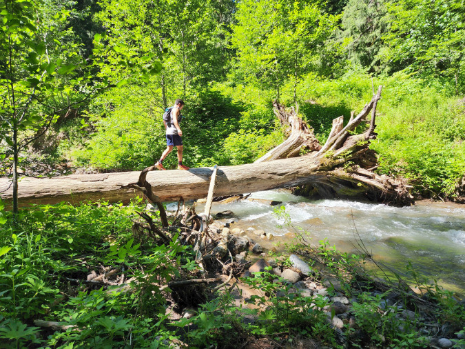
This log has survived several winters at the lower Muddy Fork Crossing, thanks to more stable banks and less channel shifting in this part of the Sandy River valley. A permanent bridge is a good option for this spot (Lily Peterson/Portland Hikers).

The lower Muddy Fork site is more like the lower Clark Creek crossing in that the stream is less volatile and the stream channel likely stable enough to support a year-round crossing structure. The site also lies in close proximity to the Ramona Falls trailhead, providing the same good access that allowed for the new wilderness bridges on Ramona Creek in recent years. This permanent crossing should also move forward now in tandem with the pilot project for seasonal crossings.

_______________

Fifteen new crossings are a lot to ask of an agency whose posture at Mount Hood has been to provide no safe crossings at all, so it would take some trail champions both within and outside the agency to take a first step. That could take the form of just a single pilot project right now, perhaps beginning on the upper Sandy River crossing that took Sarah Bishop’s life – or the lower Sandy River crossing that Sarah’s family has been advocating for? 

There are non-profit trail partners ready to help. The Forest Service already has agreements with volunteer trail organizations to maintain trails within the Mount Hood Wilderness, notably Trailkeepers of Oregon (TKO) and the Pacific Crest Trail Association (PCTA). Other organizations like the Mazamas have provided trail maintenance on select trails within the wilderness over the years, as well. Compared to the ongoing need to trim brush and clear logs, placing seasonal bridges could also be a coup for drawing new volunteers to this needed work. 
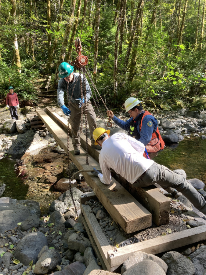
Trailkeepers of Oregon (TKO) volunteers removing the seasonal Elk Creek Bridge in the Tillamook State Forest at the close of the summer hiking season (TKO)

But there’s an outside-the-box option that the Forest Service has not considered in the past – and should. The agency grants special permits to several commercial operations to do business on our public lands, some to carry out work for the agency, like running campgrounds and maintaining trailheads. These contractors could be part of the solution, since they are already actively doing basic work for the agency.

But there’s a better opportunity worth exploring in providing these crossings: the major ski resorts on Mount Hood’s south side. In an era of climate change, the combination of shrinking, unpredictable winter snowpacks and soaring gear and ticket prices have resulted in an aging demographic of alpine ski enthusiasts in recent years. This is happening across the industry. Resorts have responded with summer activities designed to bring riders to their ski lifts in the summer months, notably mountain bike and hiking trails.

On Mount Hood, the Timberline and Ski Bowl resorts have leaned hard into mountain biking to keep their lifts busy in summer, but Mount Hood Meadows has opted for a bold focus on hiking, including construction of a dense network of trails that radiate from the day lodge and ski lift terminals. Ski Bowl advertises lift-based hiking as well, though most of the “trails” simply follow ski lift service roads, where the Meadows network offers real hiking trails built for people, not maintenance trucks. That’s a good thing!
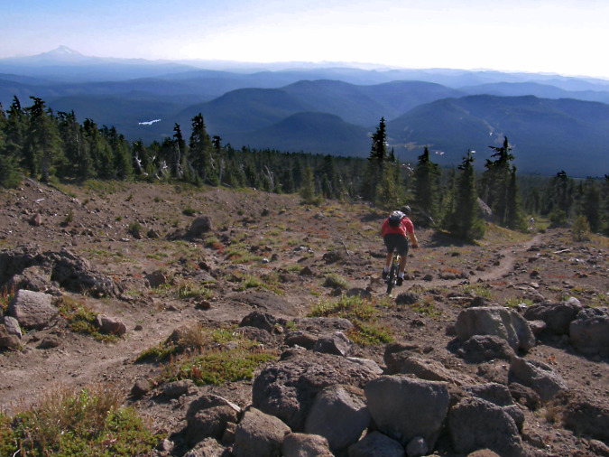
Mountain biker straying from Timberline resort private bike trails onto the public, hiker-only Mountaineer Trail, one of many public trails the resort includes in its advertised summer hiking trail network

For its part, Timberline maintains a tiny nature trail network adjacent to the historic (and publicly owned) Timberline Lodge, but the rest of the trails in its promoted network are all built and maintained by the public – including the Pacific Crest and Timberline Trail segments that pass through their permit area (though there are tremendous opportunities for the resort to help expand the system). Meadows also includes public trails in its hybrid network, including a section of the Timberline Trail, and all of its trails are open to the public. 

Therefore, why not ask the two larger resorts to participate in maintaining wilderness bridges? The Timberline resort includes both the Zigzag and White River crossings in their advertised trail system. The Meadows resort includes the upper Clark Creek crossing on the Timberline Trail and both the upper and lower Newton Creek crossings are just outside their advertised network. 
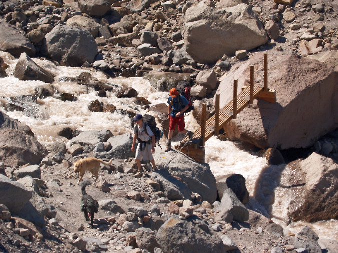
The Forest Service has some experience with seasonable bridges on the Timberline Trail. This seasonable crossing on the Eliot Branch was in place for several years in the 2000s
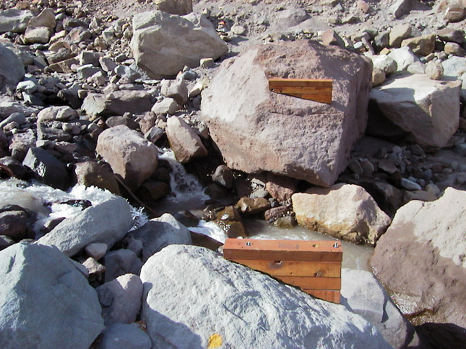
The design of the seasonal Eliot Branch crossing involved two footings bolted to boulders along the stream. This design was used within the designed Mount Hood Wilderness

It’s an idea worth exploring, as both resorts periodically renew their long-term permits to operate on public land with the Forest Service, and that’s a time when the public’s interest in their use of our lands is incorporated into a binding agreement. It’s encouraging the resorts are thinking beyond ski tickets, but it also a good time to acknowledge the commercial benefit they are receiving from public trails and ask them to step up and become a partner in making it a safe experience for everyone.

So, there are some ideas that could help us get unstuck from what is an intolerable situation on Mount Hood’s glacial stream crossings. Let’s not wait for another tragedy to point out the obvious: the glacial crossings are becoming increasingly dangerous and must be addressed, sooner or later.

Thanks for following the blog ! I hope to see you on the trail sometime! 

_____________

Tom Kloster | August 2026

Postscript: have you visited the new companion WyEast Images Blog? Be sure to subscribe while you’re there!
WyEast Blog at 10 years! (and counting!)

00_2018DufurMillRoadHoodFramed

First snow of autumn 2018 on Mount Hood as seen from Dufur Mill Road

Last November marked 10 years since I started the WyEast Blog, way back in 2008. It was a pretty hopeful year, as you may recall, followed by some very progressive reforms for how our public lands are managed.  And my, how things can change — elections do have consequences! So, as always, the work continues as we weather another round of political attacks on our hard-fought protections for public lands.

Much has changed in WyEast country over the past 10 years, too, but certainly not my commitment to a better future for Mount Hood and the Columbia River Gorge. I’m frequently asked “do you reallythink Mount Hood will become a national park?” and my response is always the same, “a little more every day!”Why? Because despite the currently bleak situation in Washington D.C., we’re (finally) witnessing the start to a changing of the guard in generational leadership at all levels of our society. The Millennials are here!
01_TomEagleCreek

Author on my last visit to Eagle Creek, about a year before the September 2017 fire

What will history say about the Baby Boomers as they (reluctantly) hand over the reins to a younger generation? For all they have given us in their epic contributions to art and culture, they have also been surprisingly awful when it comes to conservation, woefully lacking in both courage and imagination. It’s true the Millennials are overdue in taking the reins, but since twice delivering the first African American to the U.S. presidency (a man who the Boomers voted overwhelmingly against, history shall note), they have steadily expanded their presence on the local, state and national political scenes. The 2016 elections represented the beginning of what will become a tidal wave in coming years, too.

By wide margins, Millennials are genuinely committed to conservation and sustainability, more balanced in their personal lives in how they manage ambition and status, and much less materialistic and consumptive than their elders. The numbers prove this. And thus my confidence that the Millennials’ turn at governance can (and will) return us to the bold conservation legacy of past eras and previous generations of leadership. The pendulum will swing, once again, and I believe that expanding our national park system will be part of that renaissance.

In the beginning…

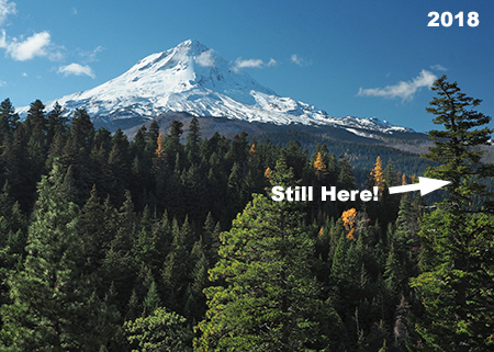
Ten years ago, I started this blog with a rather obscure look at a couple of dead trees at a favorite roadside viewpoint of mine, along Dufur Mill Road. Here’s what that spot used to look like:

02_2008DufurMillRoad

The two snags featured in the very first article on this blog… but what about the big fir on the right?

Sometime that year, both snags on the left side of the photo were felled, possibly for firewood, a common activity in that area. At the time I was dismayed at the senseless loss of a couple of valauble and (to me) beautiful snags. Mount Hood’s old ghost trees are essential for wildlife and forest health, after all! And thus, my first article began what would become many looks at the lesser-known and under-appreciated corners of WyEast country, all in celebration of our magical mountain and gorge!

Today, the view from this spot on Dufur Mill Road is still much the same, minus the old snags. Here’s what it looked like a couple of weeks ago (below), where you can pick out individual trees in the background that appear much the same. The large Douglas fir on the right side of the original photo still stands, too, but what about the apparent change in height of this tree between the above and below photos?

03_2018DufurMillRoad01

Today the two snags are long gone, but the big Douglas fir is still standing

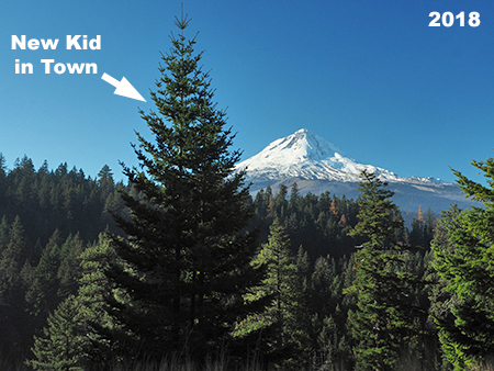
Yes, the old fir did grow, but not by that much. It turns out that in the 10 years since the original photo was taken, a young Douglas fir has grown from just a few feet tall to nearly 20 feet — blocking the original view! Here’s what today’s scene looks like as viewed from the exact spot as the 2008 photo:
04_2018DufurMillRoad02

The only true constant in the forest… is change!

The changes in this favorite spot of mine are a good metaphor for so many places on Mount Hood and in the Gorge over the past ten years, where the only constant is change. This article explores some of the changes, plus a rundown of the most read and least read articles on the blog. Hope you enjoy the look back!

The Articles

Including this retrospective, I’ve posted 184 articles on the blog since November 2008, ranging from the incredibly obscure (my favorite!) to the surprisingly popular.

In the first five years, visitors grew gradually to a couple thousand annually, then abruptly jumped to 30,000 in 2013 and 60,000 in 2014! Since then, visitors have hovered between 70,000 and 90,000 annually. A decent share also click through to the Mount Hood National Park Campaign website, and who knows? One of those visitors might be the future congresswoman or senator who introduces a bill to make Mount Hood and the Gorge a national park! That’s the goal of an “idea campaign”, after all — and why I started the blog.

But blog metrics don’t really tell the full story, as a select few posts have been the major drivers in visits over the years. These posts continue to pop up each week in the blog stats, years after they were first published.

At the top of that list is an article debunking the many persistent myths about ticks that continue to circulate among the hiking community. I published “Ticks! Ticks! (10 Common Myths” in April 2013, and it’s the main reason for the big jump in traffic that year that has since continued. The article now has 173,000 views and counting — and that’s great news, as ticks present a growing health risk in the Gorge now that Lyme disease has spread to our region.

05_Ticks!Ticks!

Nobody likes ticks… but people do like this article!

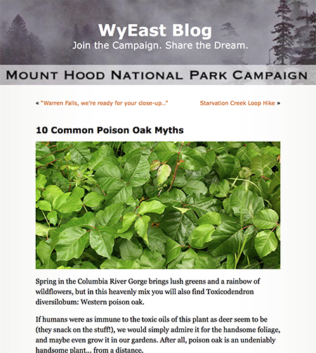
Right behind ticks in our apparent collective anxiety is poison oak, and a companion piece called “10 Common Poison Oak Myths” is thus the second most read article on the blog. A lot of bad information circulates online among hikers on both the risks and treatment for poison oak exposure. This article was posted in 2012, before the tick article, but caught fire after the piece on ticks began to drive search engines toward the blog. Today, the poison oak article has had 78,000 visitors and shows up every week in blog stats.

06_10PoisonOakMyths

I’d been itching to write the sequel to this one…

The 2017 Eagle Creek Fire kicked off a series of articles covering the aftermath of the fire. The first article featured some of the earliest views into the burn as seen from the Washington side of the Gorge, just after the smoke had cleared. This article was widely shared in social media, with 23,000 views and counting.

08_FirstLookGorgeFire

The first look into the smoky aftermath…

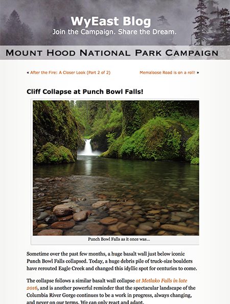
Later articles spotlighting the burn were based on State of Oregon aerial reconnaissance photos that provided exceptional detail of the devastation at iconic places in the Gorge and the nearly immediate signs of recovery that was already underway. One of these revealed a massive cliff collapse at Punch Bowl Falls in early 2018, just a few months after the fire.

07_CliffCollapse

Perhaps more shocking than the Eagle Creek Fire, itself, were the dual cliff collapses at Metlako Falls and Punchbowl Falls on Eagle Creek.

We will never know if the cliff collapse resulted from the effects of the fire, but when the State of Oregon aerial surveys revealed the collapse, it came as a shock to anyone who knew this spot. More than 25,000 readers have viewed the article and it continues to be visited regularly.

While it’s great to see a big response to an article, truth be told, my favorite posts are among the least read. This describes mostof the posts on the blog, of course!

One of these lesser-read pieces was in 2010, when I posted a proposal to restore Warren Falls, a virtually unknown spot near Starvation Creek that had been brutally altered by Highway Department engineers in the 1930s. I had long been saddened to see how this beautiful spot had been manhandled by the same Highway Department that had gracefully navigated other waterfalls in the Gorge with beautiful bridges, viaducts and overlooks, and hoped that ODOT might incorporate restoration of the falls into a major effort to reconnect the original Historic Columbia River Highway.

09_RestoringWarrenFalls

This became a bit of a crusade for a few years, including a featured spot on OPB’s Oregon Field Guide, but in the end, ODOT wasn’t interested in owning up to their crime against nature (and as I pointed out in one of the follow-up articles, the diversion was a clear violation of state statute, too!). Score another one for the highway builders, but I remain hopeful that someday we will undo this travesty.

10_RestoringWarrenFalls

Warren Falls comes (briefly) alive in 2014!

In the meantime, a vestige of the original falls appears a few times each winter when ODOT’s diversion dam and bypass tunnel are overwhelmed by high runoff, bringing Warren Falls back to life, if only briefly.

And while ODOT once again turned its back on Warren Creek, Mother Nature may bring her wrath upon the diversion structures in the aftermath of the Eagle Creek Fire. Ironically, the original project was in response to Warren Creek carrying heavy rock and wood debris onto the old highway following an early 1900s burn in the upper canyon Eighty years later, the upper canyon has burned again, and another cycle of heavy debris flows is likely in coming years. She does bat last, after all…

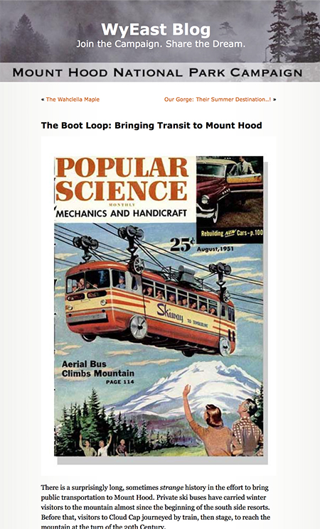
In happier ODOT news, an August 2012 article proposing a “Boot Loop” transit service around the mountain and through the gorge seemed far-fetched at the time, but ODOT has since operated transit in the west end of the Gorge and helped fund transit to Timberline Lodge. Currently, a “round the mountain” transit study is underway to explore the potential for completing the loop. That’s great news!

11_BootLoop

Not such a goofy idea after all..?

The Gorge Express and Mount Hood Express bus lines are general purpose, too, whereas the “Boot Loop” idea was more narrowly aimed at recreation. The broader transit service we’re now seeing on the ground is far better, providing essential service to places where basic transit connections were long overdue. Kudos to ODOT for moving beyond their highway roots and bringing much-needed transportation alternatives to the mountain and gorge!

10 years of Big Changes

Mount Hood and the Columbia River Gorge have seen some epic changes over the past 10 years, perhaps most notably the Dollar Lake Fire on Mount Hood’s north slope in 2012 and the Eagle Creek Fire that burned much of the Oregon side of the Gorge in 2017. But there were many other significant changes, too, albeit somewhat overshadowed by the big fire events. The following are a few “then and now” highlights of these notable changes in WyEast country over the past ten years.

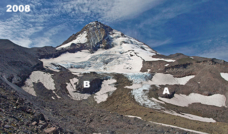
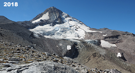
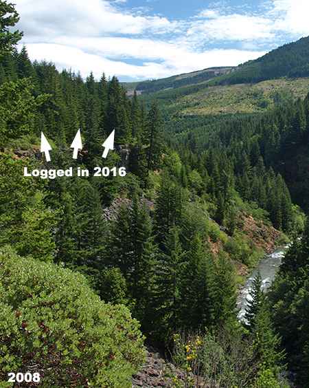
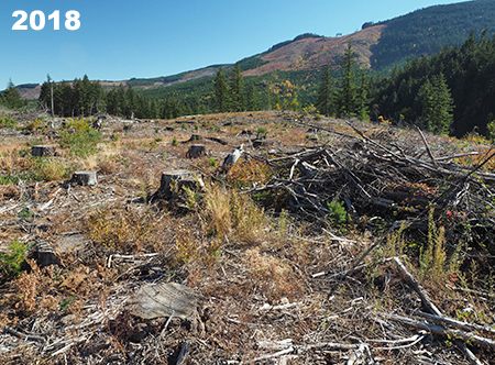
Global warming? Absolutely. Despite the frustrating, science-defying (and completely cynical) state of denial coming from the White House and Republican Party, bright red warning flags are showing up all around us, including on Mount Hood. As the photo pair below shows, the Eliot Glacier continues to recede at an alarming rate, as do the rest of Mount Hood’s twelve glaciers. I’ve marked a couple of prominent rock outcrops adjacent to the lower Eliot Galcier icefall to show how the “firn” line has retreated. The firn line is the point in a moving glacier that marks equilibrium, with the glacier is accumulating ice above the line and losing ice (melting) where it flows below the firn line.

12_2008EliotMoraine

Blue ice still spilled over the lower Eliot Glacier icefall in 2008

As the photos show, the lower icefall (just above and left of the outcrop marked “A”) is notably smaller and darker, with debris carried within the glacier now exposed by melting at this level due to the rising firn line. Both photos were taken in late summer, when summer melting was at its peak.

13_2018EliotMoraine

Global warming is rapidly changing the once-mighty Eliot Glacier

The once-permanent snowfields on the margins of the glacier are also noticeably smaller and seem doomed in the near future. Permanent snowfields are the most vulnerable ice features on the mountain and a good visual indicator of the speed in which global warming is melting our glaciers.

While future generations may forgive us for failing to actually slow or stop global warming, they surely will never forgive us for willful denial of its existence as a human-caused crisis of our own making. Let’s hope we can make up some lost ground in the near future, with the Millennial generation finally taking charge.

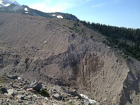
The changes to the Eliot Glacier are also being felt downstream, no more so than in the upper reaches of the Eliot Branch canyon, where a more volatile glacial outflow is rapidly carving into the once glacier-covered valley floor, constantly changing the landscape. In 2006, the stream flooded once again, greatly deepening the canyon and making it unsafe to cross for hikers on the Timberline Trail. This situation languished for nine years, with many hikers choosing to scale the crumbling canyon wall (shown below) with the aid of a worn rope anchored to a boulder!

14_2014EliotMoraine

The ever-deepening canyon on the upper reaches of the Eliot Branch

This blog played a small part in helping the Forest Service move forward with a new crossing of the Eliot Branch when a ranger from the Hood River District read this 2014 article and reached out to discuss options for a new, downstream crossing. Along the way, I updated the map from the blog article to align with Forest Service and Trailkeepers of Oregon (TKO) plans for the restored crossing, and it even made the cover of a local newspaper in Hood River! (…okay, so it’s an advertising tabloid…!)

15_2018EliotMoraine

Not exactly the New York Times, but I’ll take it!

The newly reconnected trail drops steadily from Cloud Cap Inn to a section of the raging Eliot Branch that has (somewhat) stabilized, and can be reasonably crossed in the summer months. Though there are no immediate plans for a trail bridge here, the Forest Service moved large boulders in the stream to serve as stepping stones, hopefully making the crossing a bit safer for hikers. The restored trail opened in 2017.

16_EliotCrossingUSFS2017

The newly constructed Timberline Trail just above the Eliot Crossing (photo: USFS)

Moving down to the Hood River Valley, the iconic view of Mount Hood from this field along Laurance Lake Road (below) looks much the same today as it did in 2008, albeit with some logging on private land in the distance. What you can’t see in the 2008 view is that it was captured just a year after voters approved Measure 49, which reversed 2004’s deceptive Measure 37. This earlier measure would have almost certainly brought resort development and luxury McMansions to the Hood River Valley.

17_2008UpperHoodValley

The timeless view of Mount Hood from Laurance Lake Road

18_2018UpperHoodValley

…still pretty much the same ten years later!

Even better, this farm has since come under the ownership of a member of the Parkdale Valley Land Trust, and is now even more likely to remain unchanged for the foreseeable future. Which, in turn, means that a spot that hasn’t change since the 1950s (below) might look much the same in the 2050s. That’s a great legacy being carried forward to future generations.

18a_1950sUpperHoodValley

Maybe past really can be prologue..? (photo: State Archives)

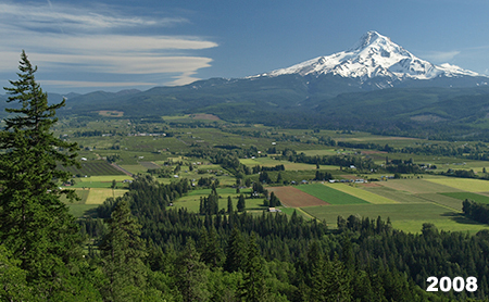
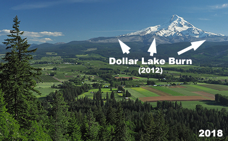
Here’s another view of the Parkdale area in the Upper Hood River Valley from Middle Mountain, a mostly county-owned forested ridge that separates the upper and lower valleys. From this spot, the most notable change is a silver band of ghost trees marking the 2012 Dollar Lake burn, clearly visible along the northern shoulders of the mountain.

19_2008MiddleMountain

The upper Hood River Valley ten years ago…

20_2018MiddleMountain

…and earlier last year…

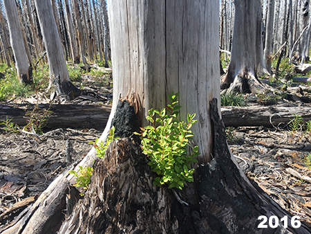
The Dollar Lake Fire was the third in rapid succession (following the Bluegrass Fire in 2006 and Gnarl Ridge Fire in 2008) to burn the slopes of Mount Hood. As jarring as the changes may be, these new burns provide a front-row seat to the rapidly recovering forest, a timeless and essential cycle that has been disrupted by the Forest Service policy of aggressive fire suppression over the past century.  State and federal land agencies have only just begun to rethink their approach to fire moving forward, a change in culture that will take many years to fully achieve, especially in the era of climate change.

21_VistaRidgeBurn2016

Huckleberries sprouting from the base of a burned snag in the Dollar Lake Burn

One unexpected benefit of the fires on Mount Hood was preparing those (like me) who love the mountain and gorge for the devastating Eagle Creek Fire that raged through the western Columbia River Gorge in September 2017. The Mount Hood fires helped many who understood the abstract benefit of forest fires come to grips with the emotional reality of seeing a favorite place changed, and begin to appreciate the stark beauty in the burned landscape and witness the unfolding forest rebirth.

For the past year, thousands of volunteers with organizations like Trailkeepers of Oregon (TKO) have been working with the Forest Service and Oregon State Parks to begin digging out miles of burned trails in the gorge. Last November, the Forest Service officially opened the first of these cleared trails, including the iconic Larch Mountain Trail that follows Multnomah Creek, giving hikers their first look at the changed landscape, and a chance to expand their own understanding and acceptance of fire in our forests.

Earlier last year, I joined TKO crews to work on the trail and capture photos of familiar scenes as they now appear, after the fire. This set shows Weisendanger Falls from the same spot before and after the fire:

22_2008WeisendangerStreamView

Weisendanger Falls on Multnomah Creek ten years ago…

23_2018WeisendangerStreamView

…and in spring 2018, after the Eagle Creek Fire swept through

While the area below Weisendanger Falls shows signs of the fire — notably , more logs in the creek — this photo pair shows the extent of the burn above the falls, where the forest was more substantially impacted:

24_2008WeisendangerPortrait

Weisendanger Falls before…

25_2018WeisendangerPortrait

…and after the fire, in spring 2018

Similar scenes can be found throughout the Eagle Creek Burn, where the fire generally left a beneficial “mosaic” pattern, with heavily burned areas mixed with largely intact forest. These areas are expected to recover quickly, with healthy patches of surviving forest helping adjacent burned areas recover by reseeding, providing cover for wildlife and creating shade. But there are exceptions, especially Oneonta canyon, where the burn was especially catastrophic. The recovery in these places will span decades.

* * * * *

Thus far in this 10-year retrospective article, the focus has been on big changes brought by nature (albeit with an assist from man), but there have been plenty of changes brought by humans over the past ten years, too — both good and bad.

Let’s start with the bad (and ugly). Tragically, corporate timber behemoth Weyerhaeuser became the major private land owner in the West Fork Hood River valley over the past decade, taking ownership of private forests that had long been held by Longview Fibre (and then briefly by a Canadian equity trader). Though Longview Fibre had greatly accelerated logging in the 2000s, Weyerhauser has ramped up the destruction and embarked on a complete liquidation of the forests along a West Fork. Their purported “sustainability” mission is laughable in the modern area of chasing stock prices with massive, unsustainable clear cutting.

This scene is along the spectacular West Fork canyon, just above the Lake Branch confluence. It’s a crime against nature that any private entity should own land of this scenic and ecologic value, and Weyerhauser’s recent “stewardship” is proof:

26_WestForkCanyon2008

Weyerhauser didn’t own it yet, but the assault had begun…

27_WestForkCanyon2018

…but Weyerhauser greatly accelerated the deforestation of the West Fork

Not seen in these photos are the miles of shoddy logging roads cut into steep slopes in order to haul out the logs and the millions of gallons of liquid herbicide sprayed on the slopes of the West Fork canyon to kill whatever vegetation managed to survive the logging show. Modern corporate logging is about exterminating native forests and replacing them with hybridized tree farms, make no mistake about it.

Some of the more appalling Weyerhaeuser logging practices are on display along the canyon section of the West Fork, where the river cascades beneath towering basalt cliffs where the scenery would merit park status anywhere else in the country. In this spot, a healthy forest directly adjacent to the canyon wall was cut in 2016 and sprayed with herbicides in 2017, with no regard to the river corridor, directly below:

28_WestForkCanyonBluff2008

A forested bluff above the West Fork canyon ten years ago…

29_WestForkCanyonBluff2018

…and in 2018 after Weyerhaeuser had “sustainably managed” it…

While it’s tough to see healthy forests cut on such a reckless scale, it’s also possible that Weyerhaeuser’s new lust for quick profits over sustainability could tempt the company to sell their cut over lands to the public in the interest of protecting the West Fork valley over the long term. After all, it will take decades for these forests to recover, and Weyerhaeuser seems to have lost patience with timelines on that scale. The sooner we can reclaim these precious lands for the public, the better.Watch for a future blog proposal on that subject!

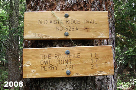
On to more positive developments!  2018 also marked the grand re-opening of the Old Vista Ridge Trail, a wonderful “lost” trail that winds north from the Vista Ridge Trailhead to a dramatic view of Mount Hood’s north side from a rocky spur known as Owl Point. The trail was unofficially reopened in 2007 by volunteers from the Oregon Hiker’s forum and maintained ever since, a project that led to the formation of Trailkeepers of Oregon (TKO).

30_OwlPointSign2008

User-made trail signs ten years ago…

Over that time, it became clear that the trail needed to be officially recognized by the Forest Service in order to be properly maintained over the long haul. After much discussion, the agency signed an agreement with TKO in 2017 to adopt the trail, caring for it in perpetuity.

The grand re-opening was originally planned for the fall of 2017, but the Eagle Creek Fire intervened, with much of the north side of Mount Hood closed to the public for fear of the fire moving south into the West Fork valley and toward the mountain.

31_ForestServiceTrailSigns2018

…replaced with official Forest Service signs last summer!

In July of last year, the rescheduled re-opening finally happened, with an official “cutting of the survey tape” with loppers and a log saw by TKO’s executive director Steve Kruger and Hood River District Ranger Janeen Tervo. A celebratory stewardship day followed on the trail, and so began a new era for this wonderful trail. TKO and the Forest Service are planning other new trails in the area, so hopefully Old Vista Ridge marks the beginning of a trail renaissance on Mount Hood.

32_OldVistaDedication

Making it official!

33_OldVistaRidgeGroup

TKO volunteers celebrate at Owl Point on dedication day

The Old Vista Ridge Trail is snowed in for the winter, now, but you can visit most years from mid-June through October to admire the view and the new, official trail signs! Read more about the trail in the Oregon Hikers Field Guide.

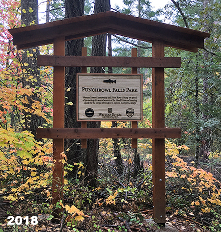
Not far from Old Vista Ridge, another “lost” spot was saved in 2015 when the Western Rivers Conservancy rescued it from Weyerhauser through a direct land purchase. Western Rivers later sold the land to Hood River County at a deep discount, thanks to a Oregon Parks and Recreation Grant, which in turn was submitted on behalf of the county by another non-profit, Thrive Hood River (then called the Hood River Valley Residents Committee). Trailkeepers of Oregon (TKO) was in the mix, too, offering to build a trail system in the new county park as part of matching contribution toward the state grant.

34_PunchbowlSign2018

This sign marks a new era for Punchbowl Falls

Sound complicated? It was! But the good news today is that most of the trails envisioned in the original park concept are now complete, and can be explored today. There are still a few finishing touches (notably, trail signs, which are currently in progress thanks to a Hood River scout troop — this is very much a DIY park!), but the main pieces to this new nature park are in place for all to enjoy.

The main focus of the new park is dramatic Punchbowl Falls, a powerful waterfall on the West Fork of the Hood River that has carved an enormous amphitheater from solid basalt. The area just below the falls is also reserved for tribal fishing, a native tradition here that spans millennia and continues to plays a central cultural and economic role for local tribes.

35_PunchbowlFalls

The massive basalt amphitheater at Punchbowl Falls

When the new trail network at Punchbowl Falls Park was first scouted in 2016, great care was taken to respect fishing paths used by the tribes to access the falls, while also providing a way for park visitors to enjoy the many views in this beautiful canyon. Another goal was to consolidate the confusing maze of user trails in the area. All of the work was completed by volunteers from 2016 through last fall.

36_ScoutingTrip2016

Volunteers scouting the proposed trail network

37_DogwoodTrail2017

Building the Dogwood Trail in 2017

38_AHS_BeforeAfter

Building the lower Yew Trail last year

The newest trail was completed last November, and follows the West Fork to the confluence of the East and West Forks of the Hood River, another popular feature in the park. Though the trails won’t be signed until early next year, they’re easy to follow and explore, and the park is especially peaceful in winter if you’re looking for a quiet walk in the forest. You can read about the hike here in the Oregon Hikers Field Guide.

39_WestForkTrail2018

The completed Yew Trail along the West Fork this fall

The new Punchbowl Falls Park spans roughly two miles of river, forever protecting land that had been left to the mercy of private timber corporations for more than a century. As if to underscore this point, Weyerhauser promptly logged off an entire hillside that rises directly above the new park before the site had even been transferred to county ownership.  Thankfully, they spared the Punchbowl property from a similar fate before selling it to Western Rivers.

40_WeyerhauserClearcutBridgeView

Thanks for the new view from Punchbowl Bridge, Weyerhauser…

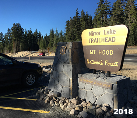
Another big change over the past decade came to perhaps the most popular trail on Mount Hood, the venerable Mirror Lake trail, located near Government Camp. For nearly a century, this beloved trail to a small mountain lake was a “first hike” to thousands visiting the mountain for the first time, including me!

41_MirrorLakeHood2008

One last snowshoe trip to Mirror Lake before ODOT closed winter access

A series of early articles in this blog focused on an ill-conceived ODOT project to widen Highway 26 in the Laurel Hill section, just west of Government Camp. The original Mirror Lake trailhead was part of the collateral damage of this now-completed road widening project. Even before the widening project, ODOT began closing the old trailhead during the winter months, cutting off access to legions of snowshoers and skiers who had used it for years. Later, the widening project finished the job permanently, and the old trailhead is now closed – including removal of the old footbridge over Camp Creek.

42_MirrorLakeSnoPark2008

Dogged snowshoers were not easily deterred by the winter closure in 2010

While ODOT focused on highway widening, a little known federal highway agency known as the Federal Lands Division worked with the Forest Service to design and build a new Mirror Lake trailhead at the west end of the Mount Hood Ski Bowl parking lot. This arm of the Federal Highway Administration also oversaw the recent replacement of the White River Bridge and restoration of the Historic Sahalie Falls Bridge, near Hood River Meadows. The new Mirror Lake Trailhead opened just a few weeks ago, and was immediately filled to overflowing with visitors.

43_NewMirrorLakeTrailhead01

The new Mirror Lake Trailhead

44_NewMirrorLakeTrailhead02

The new trailhead features toilets and handsome stone work

I’ll post a proper review of the new trailhead and trail once the snow melts this year, but perhaps the best outcome is restored winter access to the Mirror Lake area. Another important element of the project is a barrier-free design from the trailhead to a new footbridge over Camp Creek, a much-needed addition to the very limited number of accessible trails in the Mount Hood area.

45_NewMirrorLakeTrailhead03

Paved, barrier-free section of the new Mirror Lake Trail

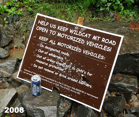
One of the more profound changes of the past ten years came when President Obama signed a major wilderness bill into law in 2009 that greatly expanded wilderness protection in the Gorge and around Mount Hood. That law protected several small areas on the margins of existing wilderness that had been left out of earlier legislation. One such area is along the western margins of the lightly visited Salmon Huckleberry Wilderness, which ironically is the closest designated wilderness to the Portland metropolitan area. The expanded boundary incorporates forested slopes of Wildcat Mountain and McIntyre Ridge that had long been tempting targets for Forest Service timber sales.

At about that time in the late 2000s, the Bureau of Land Management abruptly closed a northern access point to the Salmon-Huckleberry Wilderness, where an old logging spur provided access to the McIntyre Ridge Trail. Hikers soon discovered a new way to access McIntyre Ridge from another logging spur located on Forest Service land, which in turn led to an ancient roadbed from a long-ago era when a forest lookout tower stood on Wildcat Mountain.

46_NewMcIntyreTrailhead01

This section of the McIntyre Ridge Trail follows a former lookout access road

The Forest Service still has not embraced the “New McIntyre Trailhead”, as it is known to hikers, but this unofficial trailhead has restored public access to this newly protected corner of the Salmon Huckleberry Wilderness. More importantly, this is an area where “eyes on the forest” are especially important, as the Wildcat Mountain area has a long history of lawlessness and abuse from shooters, dumpers and 4-wheelers.

47_NewMcIntyreTrailhead02

Blaze along the McIntyre Ridge Trail

48_NewMcIntyreTrailhead03

Shooters can’t seem to resist destroying public property… and anything else they can shoot

The good news is that hikers have continued to use the McIntyre Ridge trail over the ensuing years, though there are still too many reports of illegal activity. Just last summer, a local hiker came across a pair of pickups that had driven at least a mile into the Salmon Huckleberry Wilderness along McIntyre Ridge and set up a camp in the middle of the trail! Worse, off-roaders have cut completely new roads into the wilderness on the margins of the Salmon Huckleberry, especially in this area. These are federal crimes, of course, though Forest Service resources for enforcing the law are minimal.

49_NewMcIntyreTrailhead04

Rogue off-roaders well inside the Salmon Huckleberry Wilderness earlier this year (photo: Walrus)

Fortunately, public land law-breakers are well aware of their illegal behavior and tend to shy away from busy recreation areas. Therefore, my hope is that the Forest Service will eventually recognize and champion the New McIntyre trailhead as for protecting the wilderness through “eyes on the forest”. More to come in future articles on this little corner of Mount Hood country..

And the next 10 years..?

Looking at the many profound changes in the Gorge and around Mount Hood over the past ten years, it’s easy to feel a bit overwhelmed and discouraged by the pace and scale of change. The 2017 Eagle Creek Fire was especially traumatic for so many who love the Gorge. But the changes are also a reminder of the ongoing need for vigilance in protecting these special places and the role we all have to continue moving Mount Hood and the Gorge toward a new vision of restoration and renewal and away from our exploitive, often destructive past.

I’m optimistic that we’ll continue making progress in coming years, just as we have over the past decade that I’ve documented with this blog.  I plan to continue posting articles here to track the changes and make regular deep dives into the lesser known corners of the Gorge and Mount Hood. And I’ll also dream a bit about how we might better care for these places that we all love while making our public lands more accessible to everyone.

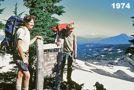
50_TomDarlene1974

Hiking with Mom on Park Ridge in my formative years!

Over the course of the past ten years, I’ve tried to post at least once per month, but you might have noticed that I haven’t quite kept that pace over the past year or two.  That’s largely due to the fact that my elderly folks have suddenly needed more help as they both struggled with failing health. In September, my mom passed away after a long and cruel struggle with memory disease, so we’ve now shifted to supporting my 89-year old dad as he adjusts to suddenly living alone after 68 years of marriage.

While sorting through family memories of Mom, I came across a photo (above) from a family backpack through the Mount Jefferson Wilderness, way back in 1974 when I was 12 years old. I was already an experienced hiker and backpacker at that point in my life, thanks to the love of the outdoors my Iowan parents shared in their beloved, adopted Pacific Northwest.

51_TomCarolDarlene1975

Me (standing on the rock, of course!) with my mom and sister on a Timberline Trail backpack in 1976

That’s a precious gift my folks gave to me and I’m thankful every day for my good fortune to have been raised with boots on my feet and a pack on my back! Too many in our spectacular corner of the world take our public lands for granted, and barely make the time or effort to explore them, often because they don’t really know how to. That’s another motivation for the blog and the Mount Hood National Park “idea campaign”. Our public lands are a gift for all of us, and I’ll also continue to post articles that celebrate this legacy and provide tips for how to explore the lesser-known corners of WyEast country.

52_TomRiversideTrail2007

Older, grayer but ready for another 10 years of celebrating WyEast!

Well, that’s probably more than enough for this retrospective article. But if you’re read this far, thank you for taking the time to visit the blog and especially those who’ve reached out with a comment or e-mail over the years. Much appreciated! I’ve got a bunch of articles and a few surprises in the works heading into 2019, and I’m looking forward to another 10 years!

I hope to see you here along the way — and on the trail, too!

_________________

Tom Kloster • January 2019

Horkelia Meadow… or is it Hackelia?

Horkelia01UpperSouthHoodView

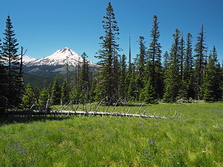
Mount Hood from Horkelia Meadow

On the east side of Mount Hood lies a pretty mountain meadow that is visited by thousands each year, but known to very few. Right about now, this little meadow is in its peak summer bloom, thanks to a low snowpack this year. The place is Horkelia Meadow, a modest, subalpine gem in the Fire Forest country of the eastern Cascades.

If you’ve ever traveled Lookout Mountain Road to the High Prairie trailhead, you’ve passed right through Horkelia Meadow, though you can be forgiven for not being familiar with the name. Years ago, a Forest Service sign marked the spot, but only a discarded signpost remains today.

Horkelia02LookoutRoad

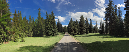
Horkelia Meadow straddles popular Lookout Mountain Road

Horkelia Meadow marks an area where a layer of underlying volcanic rock forces the water table to the surface at the top of the steep western scarp of Lookout Mountain. The geology creates a number of springs in the vicinity, and at rolling Horkelia Meadow, the soils are just moist enough to keep the surrounding conifer forests at bay.

The resulting meadow is the perfect habitat for an array of wildflowers and wildlife. You’re likely to see elk and deer sign here, as well as raptors in the big trees that edge the meadow, preying on mice, voles and even the snowshoe hare that live here.

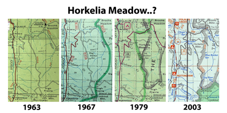
Horkelia03TopoMap

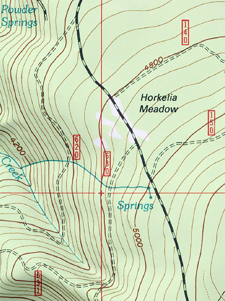
Horkelia Meadow is located in the subalpine forests on the north slopes of Lookout Mountain

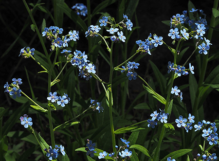
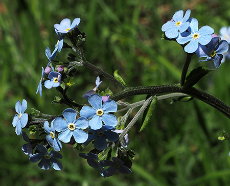
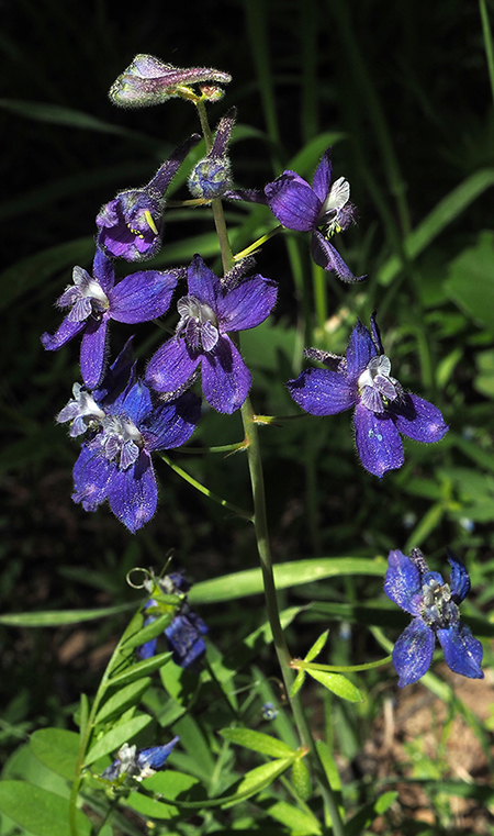
Among the earliest blooms of summer at Horkelia Meadow come from a wildflower commonly known as Jessica Sticktight, Blue Stickseedof simply Stickseed. These are showy flowers that line the borders of Horkelia meadow, along the forest margins.

Horkelia04HackeliaMicrantha

Blue Stickseed

Horkelia05HackeliaMicrantha

Blue Stickseed flower detail

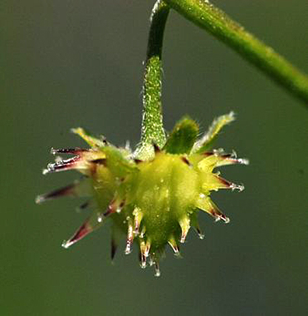
The common name “Stickseed” is self-explanatory when you look at the seed pods that form after the bloom, with each fruit covered in sticky spikes (below). When they dry out in late summer, they’re well designed to hitch a ride on passing wildlife — or your hiking socks!

But what caught my eye after a recent visit to the meadow was the botanical name for Blue Stickseed: Hackelia micrantha.Surely, there must be a connection to the naming of Horkelia Meadow?

Horkelia06HackeliaMicranthaCaliforniaNativePlantSociety

Seed pod on Blue Stickseed (photo: California Native Plant Society)

After searching through a stack of wildflower guides and web resources, I learned that Horkelia fusca or Tawny Horkelia does, indeed, grow in the area. It has been spotted at nearby Bottle Prairie and Brooks Meadow, both located to the north of Horkelia Meadow and about 1,000 feet lower in elevation.

So, a return trip was in order to see if Horkelia fuscaactually grows at Horkelia Meadow. Sure enough, it’s scattered throughout the lower sections of the meadow, far from Lookoout Mountain Road. Where Blue Stickseed is abundant throughout the meadow, Tawny Horkelia is scattered about, sometimes in open forest along the meadow edges, sometimes in dry spots near the center of the lower meadow.

Horkelia07TawnyHorkelia

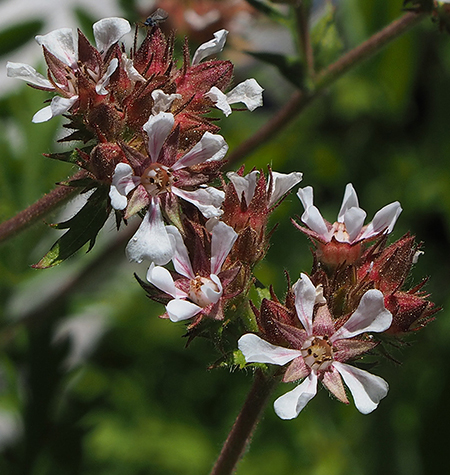
Tawny Horkelia at its namesake meadow

Compared to the showy Blue Stickseed, Tawny Horkelia is a humble bystander in the meadow. These are modest little plants, happy to fill a niche in the ecosystem, but mostly noticeable to wildflower fans.

Therefore, my hunch is that a case of mistaken identity made its way onto Forest Service maps, as Hackelia micrantha— the Blue Stickseed — is lush and very prominent in the meadow during its bloom, and worthy of being its namesake. It’s also dominates along the heavily traveled upper meadow, where Lookout Mountain Road passes through, and where Tawny Horkelia doesn’t seem to grow.

Meanwhile, it also seems that Horkelia Meadow was named fairly recently. The original primitive road was built through the meadow in the 1930s as part of the Bennett Pass Road (see this article on the blog), but Forest Service maps suggest that the Horkelia Meadow was named sometime in the early 1970s.

Horkelia08MapHistory

[Click here for large view]

This is when industrial logging and associated road building went into high gear in the Lookout Mountain area (see below), and the old dirt road to Lookout Mountain was rebuilt and graveled to handle log trucks. During this period, named landmarks were helpful for logging crews navigating the tangle of new roads. I think Horkelia Meadow was (mis)named for that very purpose.

Horkelia Meadow has a bouquet of wildflower species and is a fine spot for a casual ramble to explore its secrets — hidden in plain sight! In early summer the Blue Stickseed are joined by Larkspur sprinkled throughout the meadow. Later, Scarlet Gilia, yellow Buckwheat and blue Lupine take over in a second wave of flowers.

Horkelia09Larkspur

Larkspur in early June at Horkelia Meadow

Horkelia10Lupine

Lupine just beginning to bloom in early June at Horkelia Meadow

Horkelia11ScarletGilia

Scarlet Gilia in late June at Horkelia Meadow

In addition to the wildflowers, low thickets of Sticky Currant also grow on the meadow margins and along fallen trees that have dropped into the meadow (below). The summer berries on this species of currant are (as the name suggests) sticky and not edible, but the flowers put on an attractive show in early summer.

Horkelia12Currant

Sticky currant at Horkelia Meadow

The summer wildflower show also extends into the shade of the forests that surround Horkelia Meadow, with lush carpets of Vanilla Leaf (below), white Anemone and other wildflowers more commonly found in the wet forests along the Cascade crest.

Horkelia13VanillaLeaf

Vanilla Leaf at Horkelia Meadow

Fire suppression in the 20th century combined with aggressive clear cutting by the Forest Service over the past four decades has disrupted much of the Fire Forest ecosystem on the east side of Mount Hood. In many areas, the result is a crowded thicket of true firs, replacing the fire-dependent species of Ponderosa pine, Western larch, Lodgepole pine and Douglas fir that used to dominate. This, in turn, has triggered a cycle of beetle infestations among the crowded, weakened fir forests across the mountains of Eastern Oregon, often followed by catastrophic fires that kill even the fire-dependent tree species.

The good news is that the Forest Service has begun thinning some of these unnatural forests in an effort to restore the Fire Forest structure, including the use of controlled burns in some areas (see “Fire Forests of the Cascades”) Over time, this could help restore the natural forest ecosystem.

Horkelia14BurnedStump

A walk around Horkelia Meadow shows remnants of the old Fire Forest cycle that once dominated the area, creating open, park-like forests under towering trees. If you look closely, you can even find a few traces (above) of the last forest fire to sweep through the area, decades ago, when the forests were much different than today.

Horkelia15LarchGrove

A trio of fire-dependent Western Larch along the east margins of Horkelia Meadow

Whether fire returns to the areas as a planned burn or natural event, the Fire Forest species are still here and ready to resume their role as the dominant trees of this ecosystem… if we will allow it.

Exploring Horkelia Meadow

Horkelia16SmallMap

[Click here for a handy, large map to print for your tour!]

The old Fire Forest remnants scattered around Horkelia Meadow, some living and some standing as skeleton trees, provide easy landmarks for a tour. The starting point for exploring the meadow is the high point at the east end of the meadow, just off the Lookout Mountain road (from the recommended parking spot described at the end of the article, follow the road uphill for 100 yards).

At this upper end of Horkelia Meadow stands a gnarled, burly skeleton of what I call the “Big Bear Tree” (below), as it looks like it might be lumbering off into the woods, having lost his top. The low, dense branching on this ancient skeleton suggests this was an enormous Englemann spruce, a species that thrives in forests along the Cascade crest, especially along meadow margins. A living Englemann spurce can be found at the lower edge of of the main meadow, below.

Horkelia17BigBearTree

The “Big Bear” skeleton tree at the upper end of Horkelia Meadow

In early summer, the meadows around the “Big Bear Tree” are also filled with Blue Stickseed and Larkspur.

Heading downhill and across the road, pass a larch grove and head toward the bones of a very large, double-trunked Ponderosa pine (below). I call this old tree the “Patriarch” because it clearly ruled over Horkelia Meadow until fairly recently. Air photos show this giant still standing and alive in 2005, but toppled by 2010. The amount of bark left on the trunk is a good indicator of how recently this tree died.

Horkelia18PatriarchTree

“Patriarch Tree” at the center of the meadow, a huge, double-trunked Ponderosa pine that has toppled within the last decade or so

Horkelia19PatriarchTree

Newly toppled Patriarch Tree at Horkelia Meadow

Next, head downhill into the main meadow, located to the west and tucked away from the road, out of sight to passing travelers. Here, a large, multi-trunked Ponderosa Pine I call “The Flyswatter” towers over the scene at the north end of the meadow. This big snag is a favorite of raptors, especially owls, and is actually two snags, with the tall, single-trunked skeleton of what was likely a Grand fir wrapped in the bleached limbs of the old Ponderosa.

As you walk toward “The Flyswatter”, look for a couple of handsome Lodgepole pine growing along the east margin of the main meadow, another important species in Fire Forests.

Horkelia20Flyswatter

“The Flyswatter” skeleton tree and the lower part of Horkelia Meadow

Horkelia21FlySwatter

“The Flyswatter” tree skeleton

Just beyond “The Flyswatter” (and over a large, collapsed trunk you’ll need to navigate) is the mostly hidden northwest meadow. This pretty spot used to be guarded by another large Ponderosa pine that has long since become a skeleton, and now lies across the meadow. Based on air photos, it looks to have fallen sometime in the 1970s (below). I call this one the “Dragon Tail” tree (below).

Horkelia22Dragon

The “Dragon Tail” tree in the hidden northwest meadow

Returning to the main meadow, a pair of big Ponderosa pine come into view (below) at the top of the slope. I call these the “Odd Couple”, as one is a nearly perfect Ponderosa specimen, while its twin is anything but, with a twisted, leaning top and huge, gnarled branches. Both were once in the shadow of the massive “Patriarch Tree”, whose skeleton lies just a few yards away.

Horkelia23OddCouple

The heart of Horkelia Meadow, with the “Odd Couple” to the left of center

Horkelia24OddCouple

The “Odd Couple” at the center of Horkelia Meadow

The grassy, shaded landing between this pair of Ponderosa makes a nice spot to relax and enjoy the surrounding meadow. From here, you can appreciate the tortured life of the southernmost tree of the pair. The deep scar running down the west side of its trunk and deep wound at the base of the trunk suggest a lightning strike — a common cause of demise for big trees that grow in exposed places like Horkelia Meadow (below).

Horkelia25OddCouple

Scarred trunk of the southernmost “Odd Couple” pair

Lightning may have taken out the nearby Patriarch Tree, too — seen here from the Odd Couple:

Horkelia26OddCouple

The “Patriarch Tree” skeleton lies just beyond the “Odd Couple”

Look up into the tortured twin and you can see (below) that the main trunk is really a surviving limb that took over to replace the main trunk after the original top was destroyed — whether by lighting or simply a windstorm.

Horkelia27OddCouple

The curvy, leaning top of the southern “Odd Couple” twin

The base of this old tree (below) shows another familiar trademark of big Ponderosa pine, a broad dome of “puzzle pieces” that have accumulated around the tree over the decades. These platforms of accumulated bark chips and pine needles give these handsome trees their park-like appearance, as if the meadow has been carefully trimmed around the tree.

Horkelia28OddCouple

Ponderosa bark piled up to form an apron around this giant at Horkelia Meadow

Ponderosa don’t choose to be multi-trunked, but they can adapt this way when topped by weather or lightening. The extra load of lateral limbs adapting to become a replacement trunk results in some very impressive trees, with upturned limbs 18″ or more across emerging from the trunk of the twisting “Odd Couple” twin (below). Over time, though, these trees are still more prone to collapse than single-trunked trees from heavy snow accumulation or wind on their bulky branch structure.

Horkelia29OddCouple

Heavy-duty limbs on the more gnarled of the “Odd Couple” Ponderosa pair

The bark on Ponderosa pine is both fascinating and beautiful. The puzzle-like flakes (below) continually shed as the bark on the tree grows. The dark furrows in the bark form as the tree expands under its thick bark jacket, pulling it apart

Horkelia30OddCouple

Bark detail on the more gnarled of the “Odd Couple” Ponderosa pine

Ponderosa pine bark on a mature tree can be several inches thick, and this is the main defense against fire, a needed and necessary part of the Fire Forest ecosystem. The combination of protective bark and high crown allows the biggest trees to survive multiple fires and thrive to produce offspring after each successive burn. In this way, the recently fallen “Patriarch Tree” could easily be the parent of the “Odd Couple” and other big Ponderosa pine around Horkelia Meadow.

Horkelia31OddCouple

Recent cones from the more gnarled twin of the “Odd Couple” Ponderosa pine at Horkelia Meadow

The gnarled sibling in the “Odd Couple” has had a harder life that its twin, for sure, but it continues to generate cones and seeds (above). In the end, that’s all a Ponderosa Pine lives to do, no matter how funky its shape. Over time, the toughest, most resilient trees decide the future of the forest with their offspring.

Horkelia32OddCouple

Old fire rings between the “Odd Couple” Ponderosa pine trees

If you do find yourself having a snack or picnic under the “Odd Couple”, you won’t be the first. Nearly lost in a thick carpet of Ponderosa needles is a pair of old fire rings (above). How long since these were uses? Decades, perhaps? They could even date back to a time when herders brought sheep up from the Dufur Valley to graze the slopes of Lookout Mountain in the early 1900s, and have since been forgotten in this little meadow (and just in case, please leave them be as remnants from an earlier time).

So, where’s the mountain?

Horkelia33SouthMeadowHood

Mount Hood from the lower south meadow

The upper and main meadows offer occasional peeks at the top of Mount Hood, but the best views are from the south meadows, located downslope from Lookout Mountain Road, beyond a curtain of trees. Here, the western scarp of Lookout Mountain begins to fall away quickly, with the south meadows perched above steep forested slopes, below.

To reach the hidden south meadows, head across the main meadow through a gap in the trees that is directly in line with the Odd Couple. Here, you’ll arrive at the top of the upper south meadow, and you can then meander downhill through another gap to the larger, lower south meadow. Mount Hood Views abound here, and the lower meadow is also a fine spot for a picnic.

Horkelia34LowerSouthMeadowBluegrassRidge

Bluegrass Ridge from the lower south meadow

The view from the lower south meadow also includes Blue Grass Ridge, which forms the eastern edge of the Mount Hood Wilderness. From here, you can see the traces of the 2006 Bluegrass Fire that burned most of the crest of Bluegrass Ridge, and the 2008 Gnarl Fire that burned the eastern slopes of Mount Hood all the way to Cloud Cap Inn, on the northwest horizon.

These recent burns are recovering quickly, with a bright green understory of Western larch, Lodgepole pine and White pine emerging under a ghost forest of bleached snags. While these were the first fires to burn the east slope of the mountain in more than a century, the landscape they left behind is what the area looked like before fire suppression in the 20th Century — a diverse mosaic of mature and recovering Fire Forests.

Horkelia35SouthMeadowSharkFishing

Shark fishing in the south meadow… can you see “Jaws”?

There are a few more name-worthy skeleton trees along the way as you drop down to the lower south meadow. First, you’ll pass a bleached stump that I originally called “Jaws”, but then spotted a “fisherman” complete with a deep sea fishing rod just up the hill — and thus, “Shark Fishing” for this trio (above).

At the top of the lower meadow a pair of stout Ponderosa skeletons are the “Goal Posts” (perhaps because it’s World Cup season). The meadows just below the “Goal Posts” have an excellent mix of wildflowers right now, too, and are where the Scarlet Gilia were in bloom on my last visit.

Horkelia36SouthMeadowGoalPosts

The Goal Posts in the lower south meadow

I know it’s a little silly to name all of these ghost trees, but hopefully it will help navigate the meadows if you choose to visit. It’s also a way for me to stop and appreciate the story each of these silent old patriarchs has to tell… and it’s just fun, too!

Horkelia Meadow at Work

I used to worry that fallen trees would eventually consume precious meadows with the accumulating debris, but it turns out that the meadows do just fine in consuming the trees, instead. One phenomenon you might notice as you explore Horkelia Meadow is log traces. These look like very straight trails, at first, but are really just places where fallen trees have nearly been absorbed into the meadow, and the grasses and wildflowers have all but covered what’s left of the fallen log.

There’s a prominent log trace in the upper south meadow that tells the story nicely. Fuzzy air photos from the mid-1990s (below) show a pair of fallen, bleached skeleton trees lying intact across the meadow. These trees could easily have stood as snags for decades after they died, but once on the ground, trees begin to decompose much more quickly.

Fifteen years later, in 2010, air photos show that the smaller of the two skeleton trees had really begun to fall apart, while the larger tree was mostly intact and still many of it’s bleached limbs.

Horkelia37LogTraceComparison

[Click here for a large view]

By last summer, however, air photos show the smaller tree had faded to a line of decaying wood in the meadow and the larger tree has lost most of its remaining limbs over the previous seven years. Today, the smaller tree has left just a trace in the meadow, and will soon completely disappear.

This cycle has played out countless times at Horkelia Meadow over the centuries, with many trees falling and fading into the meadow, each adding more valuable organic matter to the soil in the process. While new trees continue to emerge along the meadow margins, they’ll eventually suffer the same fate, too. The meadow is holding its own in this battle with the surrounding forest!

Horkelia38SnagSeedling

Young Grand Fir growing where an old giant once stood

As you explore the lower south meadow, you may notice a lot of blowdown along the lower margins of the meadow. These trees weren’t brought down by old age or meadow moisture, but instead were victims of a late 1980s clearcut. The extent of the clearcut is obvious on the map at the top of the article, and as you can see, it is littered with blowdown.

The fallen trees in the clearcut all point uphill. That’s because the prevailing winds coming from the west pushed them that way after the surrounding forests were logging, leaving the remaining trees suddenly exposed them to the full brunt of winter storms. Some of these could have simply been left behind by loggers — perhaps they too small to bother cutting — and larger trees might have been left to reseed the clearcut. Most have since toppled.

Horkelia39ClearcutBlowdown

Heavy blowdown on the edges of the 1980s Horkelia clearcut

Other blowdown along the margins of the meadow occurred in areas where trees were clearly left standing as a failed “buffer” to protect the meadow — a common practice that has destroyed thousands of trees along similar clearcut margins throughout the Mount Hood area. And after thirty years, the clearcut is just beginning to recover from logging, yet another reminder that high elevation clearcuts in the Cascades were never a sustainable practice, and never should have happened. Let’s hope we’ve seen the end of it here.

If you walk through the old clearcut, you’ll also notice hundreds of what look like small, nylon mesh bags sprinkled about. These were used to protect new  seedlings when the clearcut was stocked with a new “plantation” of trees. It’s another failed effort, as most of these seedlings did not survive the harsh winters and dry summers here.

Horkelia40ReplantingBag

Non-biodegradable seedling nets from the 1980s logging at Horkelia Meadow

Unfortunately, you will also notice these little mesh bags throughout the lower south meadow. Whether intentional or simply through sloppy incompetence, the Forest Service actually “replanted” a natural meadow when the adjacent clearcut was replanted. What were they thinking? Fortunately, all that survives are the dozens of nylon bags, and the meadow remains intact and thriving today.

If you’re looking for a community service, scout troop or other group project and want to help Horkelia Meadow out, I suspect the Forest Service would give you the okay to retrieve these bags from the meadow. Unfortunately, they are not biodegradable, so will be there until they are removed. They’re held down by metal stakes, but can be pulled out by hand if you wear a pair of heavy gloves. Give the Hood River Ranger District a call if you’re up for the task!

How to get there…

Horkelia Meadow is easy to visit, and makes for a nice add-on to your trip to Lookout Mountain or other hikes in the area. It’s best visited in morning or evening, as the southwest exposure is often hot during the summer. You can walk the margins of the meadow in under an hour and gain a nice appreciation of flora, large and small, of this lesser-known spot.

Horkelia41SignPost

All that’s left of the old Horkelia Meadow sign is this old signpost

To find the meadow, follow paved Forest Road 44 about 3.5 miles from the Highway 35 junction, toward Dufur. Just beyond the busy Surveyors Ridge Trailhead (on the left), watch for the poorly signed Lookout Mountain (Road 4410), on the right. Horkelia Meadow straddles this dusty, sometimes bumpy gravel road 1.3 miles from the Forest Road 44 junction.

Horkelia42Road140

Park at the marked Forest Road 140 spur

I recommend parking at the junction with primitive road 140, on the left as just as you reach Horkelia Meadow. There’s room to park here without impacting the meadow wildflowers, but be sure you don’t blog the spur road.

To tour the meadow, walk up the road to the upper end, watching for the “Big Bear” skeleton on the left, then use the map at the top of this article to find your way.

Horkelia43BotanyClass

Botany class exploring Horkelia Meadow

To help protect the area, please follow these basic rules of meadow etiquette when exploring, as there is no developed trail at Horkelia Meadow:

  • Hose or brush off boots before every hike to help slow the spread of invasive species, especially when hiking off-trail
  • Don’t gather flowers, seeds or anything else in the meadows — “take only memories (and photos) and leave only footprints”
  • Don’t step on flowering plants, step between them
  • Try not to follow faint paths you might encounter in the meadows — while they are likely deer or elk trails, repeated walking on them could make them permanent
  • No fires, dogs, loud voices or drones (aargh!) that might disturb the wildlife and other visitors when venturing off-trail, especially in meadows

You’ll undoubtedly have the place to yourself — but if you should see a car parked along the road, consider stopping another time for your visit.

Thanks, and enjoy Horkelia Meadow! Or is it Hackelia Meadow…?