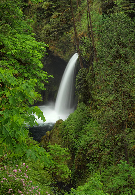
A view of Metlako Falls from days gone by…
The Eagle Creek canyon is the undisputed jewel of the Columbia River Gorge, thanks to a string of dramatic waterfalls and a precarious, cliff-hugging trail built over 100 years ago by visionary Forest Service pioneers. But starting in late 2016, a series of calamities over the course of just a year reshaped Eagle Creek for the foreseeable future.
The first of these events came in late December 2016, when a huge section of cliff at Metlako Falls calved off, damming Eagle Creek with a massive pile of debris and erasing the iconic viewpoint of the falls (where the above photo was taken in 2013) forever.
Round two was the sprawling Eagle Creek Fire the followed in September 2017, burning all but a few strips of streamside forest in the Eagle Creek draining. Then, sometime in early 2018, another massive cliff collapse occurred at Punchbowl Falls, rerouting the entire creek and forever changing still another iconic view.
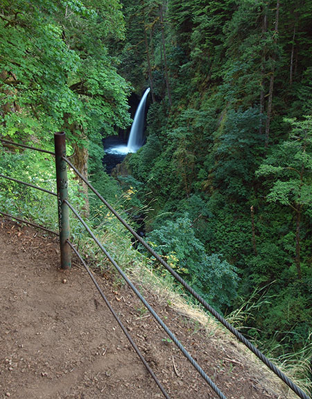
The old viewpoint at Metlako Falls
Changes on this scale are nothing new in the Gorge. In fact, they are the very processes that created the scenery we enjoy today. Without fire, we wouldn’t have cliff top meadows, gnarled Oregon white oak groves and huckleberry fields on the highest ridges that rim the Gorge. Without landslides and cliff collapses, we wouldn’t have vertical basalt canyons and the towering waterfalls within them. In this way, the changes at Eagle Creek have given us a rare look at the natural forces behind the beauty, and a chance to better understand and appreciate the ongoing evolution of this very unique place.
Since the 2017 fire, volunteer trail crews have been working with the Forest Service to restore the Eagle Creek Trail. The fire heavily impacted the trail (see Eagle Creek: One Year After the Fire), and volunteers have invested thousands of hours clearing logs and debris and rebuilding much of the trail tread. For its part, the Forest Service is working to replace several large footbridges that were destroyed by the fire.
With the reopening of the trail imminent (perhaps as early as this year) there remain plenty of questions about how Eagle Creek will be better managed in the future to prevent a recovering ecosystem from being impacted by swarms of visitors. This article focuses on anticipating and managing these impacts at Metlako Falls, where hikers will almost certainly create a cobweb of user trails in search of an alternative to the collapsed viewpoint, especially now that the dense understory that once hid the falls from the trail has burned away in the fire.
Opportunity from calamity..?
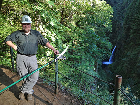
The author trimming brush at the old Metlako Viewpoint in 2013 (Photo: Christopher Alley)
The joy of the old Metlako Falls overlook was in the discovery. A pair of modest spur trails dropped through forest to a sudden and spectacular overlook, where a pair of braided cable railings stood between you and the sheer, 200-foot drop into Eagle Creek.
As iconic as the view up the narrow gorge to Metlako Falls was, it was also tedious to maintain. The cliff top just below the railings was dense with understory, which regularly grew to obscure the view of the falls. Trimming the brush required professional crews equipped to descend the cliff with ropes or volunteers willing to pack a pole pruning saw up the trail. It was an ongoing battle, with the understory winning — and hikers inevitably crawling over the railing for a better look. It’s a miracle that nobody (that I know of) slipped over the side at the old overlook!
In this way, the cliff collapse in 2016 and fire in 2017 offer an opportunity to create a new viewpoint at Metlako Falls that is both easier to maintain and provides less incentive for hikers to explore beyond the trail. I believe such a spot exists and that a spur trail to this new viewpoint could easily be developed by the volunteer crews already working to restore the Eagle Creek Trail. I also believe that without creating a new viewpoint, the crush of hikers who use this trail will seek one out, creating a hazard for hikers and harming the recovering landscape in the process.
Cue the helicopter!
Here’s a not-so-secret scoop: for the past decade or so, daredevil kayakers have been sailing over Metlako Falls as part of the “extreme kayaking” phenomenon of waterfall jumping. These stunts at Metlako Falls have been regularly recorded for social media (of course!) and thus a well-worn user path already descended to a viewpoint directly opposite the falls well before the Eagle Creek Fire swept through the area.
The post-fire absence of forest understory will make this user trail all the more obvious, and thus my confidence that it will become a heavily used boot path when the main trail reopens if a planned alternative isn’t provided. The time to act is now, before hordes of hikers are allowed back into Eagle Creek.
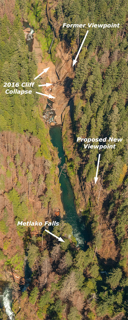
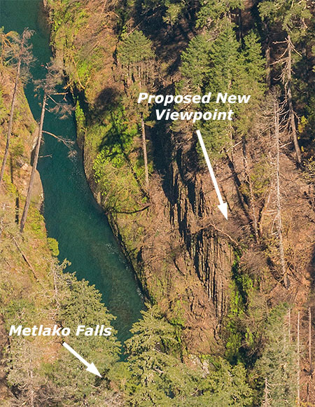
So, where is this not-so-secret user path? The following views from one of the State of Oregon helicopter surveys of the Eagle Creek Burn were taken in 2018, and show the unofficial Metlako Falls viewpoint nicely.
This wide view (below) is looking downstream, with Metlako Falls hidden in trees, but the deep pool created by the 2016 cliff collapse showing up prominently. I’ve marked both the site of the original viewpoint and where the proposed new viewpoint would be, roughly located where the kayaker path now leads:
This closer view (below) shows more detail of the proposed new viewpoint. Notably, it’s located atop a sheer basalt cliff that would provide a clear view, but could also discourage hikers from venturing beyond the viewpoint. Also notable are the many surviving conifers on the bench that forms the viewpoint that will help stabilize this area in coming years as the understory recovers from the fire.
What does Metlako Falls look like from this new perspective? It’s a straight on view that resembles a verytall Punch Bowl Falls, based on the many kayaker photos out there. This unattributed social media image shows a kayaker jumping the falls from the not-so-secret viewpoint in about 2015:
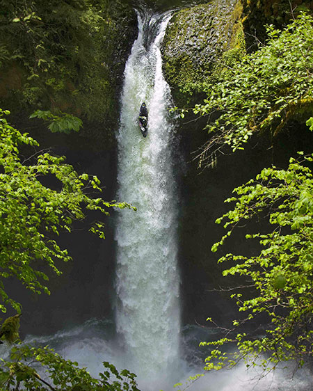
Metlako daredevil as viewed from the proposed viewpoint (Source: Unknown)
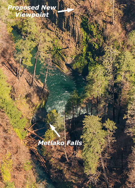
This State of Oregon aerial view (below) was taken from almost directly above Eagle Creek as is rushes toward the brink of Metlako Falls and provides another good look at the basalt columns that are the foundation for the proposed new viewpoint:
This aerial view (below) is from above the proposed viewpoint, looking back at Metlako Falls. From this angle, it really does resemble a very tall Punch Bowl Falls, complete with a deep amphitheater behind the falls and rock fins hemming in the splash pool on the downstream side:
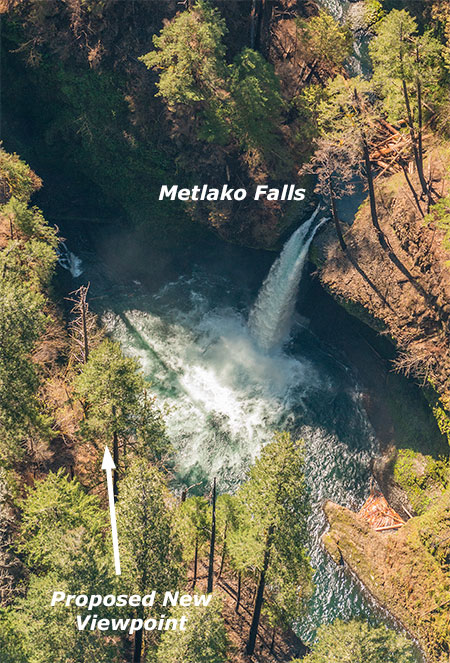
This wide view (below) is the reverse of the opening State of Oregon aerial, looking upstream toward Metlako Falls. This view shows the debris from the 2016 cliff collapse and the dammed section Eagle Creek above the debris pile.
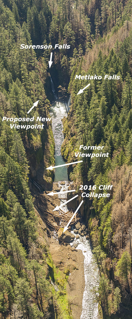
But there’s also a surprise next to Metlako Falls in this view. The slender cascade dropping into the opposite side of the Metlako amphitheater is Sorenson Falls, a seldom-seen beauty not visible from the old viewpoint. Could the new viewpoint be designed to allow this beautiful falls to be seen, as well? I think so — and in that way, the new viewpoint might be even more spectacular than the old one!
So, how do we do this?
While the Forest Service has been reluctant to even consider new trails in the Gorge in recent years, the Eagle Creek Fire may have created a window of opportunity for rethinking the status quo. However, the need for a formal environmental assessment is often a Forest Service obstacle to building new trails, even if the agency is open to the idea. But there’s a shorter path for the proposed Metlako Falls viewpoint. The National Environmental Protection Act (NEPA) calls out “categorical exclusions” for certain activities that exempts them from having to complete an environmental assessment. The proposed viewpoint easily meets this test.
This is because one of the “exclusions” under NEPA are trails negatively impact by natural events (like a fire or cliff collapse) and the Act gives great latitude to the Forest Service when relocating or realigning trails in response to such events. The Forest Service would still need to rely on agency scientists to complete a site evaluation of a proposed spur route for soil stability and other design considerations, but much of the expensive and effort required for a full environmental assessment can be avoided.
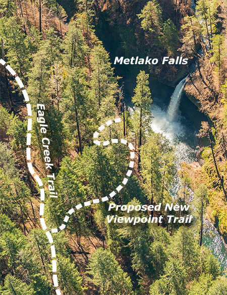
The new spur trail would be very short — only about 100 yards in length and descending about 50 feet in elevation from the existing Eagle Creek Trail (see schematic, above). This not only helps make the case for a categorical exclusion, it also puts the proposed trail within reach for volunteers to both design and construct in cooperation with the Forest Service.
The viewpoint, itself, would likely require the Forest Service to design of some sort of cable railing, perhaps similar to the old viewpoint and the Punch Bowl Falls overlook, or possibly a deck similar to the structure at Panther Creek Falls. But even this detail is within reach for trail volunteers to constructing, with the Forest Service simply providing the design and materials.
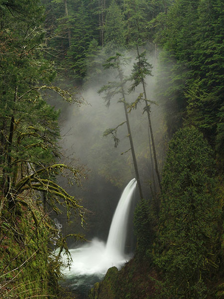
Misty Metlako Falls in the winter of 2014
If some other alternative isn’t provided, hikers will almost certainly follow the kayaker’s user trail to the unofficial Metlako Falls viewpoint when the Eagle Creek Trail is reopened. With volunteer crews already working to reopen the trail, it makes sense to build this viewpoint spur now. My hope is that we can be proactive and create a stable, sustainable way for hikers to view the falls before thousands of boots on poorly aligned user trails force the Forest Service to react.
______________________
Postscript: I probably should have included this when I posted the article, but you can comment directly to the Forest Service in support of this proposal on their website:
