
Hidden in plain sight near the west entrance to the Columbia River Gorge are a string of waterfalls that flow from the slopes of Devils Rest and Angels Rest, yet are virtually unknown. At least one of them, Dalton Falls, is named. But nobody seems to agree which waterfall is the real “Dalton”.
A closer look at a 1916 touring map (below) published when the original scenic highway opened in the Gorge shows this area in detail, including a few name changes: “Fort Rock” is now Angels Rest and the domed butte at the top center-right edge is Devils Rest, which forms the headwaters of well-known Wahkeena Falls — then known as “Gordon Falls”.

Multnomah, Mist Falls and Coopey Falls are also shown, and still carry their original names (Mist Falls is one of the few landmarks in the Gorge that still carries a name given by the Lewis and Clark expedition). But tucked between Coopey Falls and Mist Falls on this old map is “Dalton Falls”, shown to be flowing from a prominent canyon on the east flank of Angels Rest (then “Fort Rock”).
This is where the confusion begins, as the stream in this canyon does have several small cascades, but nothing that could have been easily seen from below, along the old Columbia River Highway, which seems to argue against this falls being the real “Dalton Falls” Meanwhile, one of the lesser-known waterfalls in what I am calling the “Heaven and Hell” section of the Gorge is quite prominent, and to many waterfall admirers is the rightful “Dalton Falls”.
The photo below is from state aerial surveys taken after the Eagle Creek Fire in 2018, and shows both the familiar Mist Falls and nearby “Dalton Falls”, just to the west.
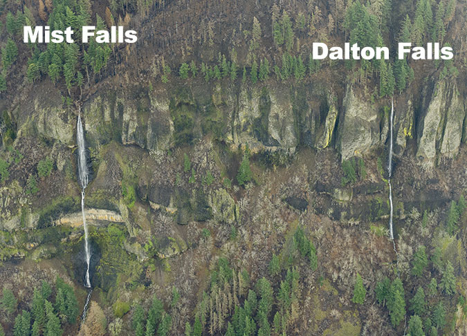
Like Mist Falls, Dalton Falls is a two-tiered waterfall with a total height of 350 feet — not as tall as nearby Mist Falls at 520 feet, but quite tall compared to other waterfalls in the Gorge. In most years, Dalton Falls is seasonal, going dry in late summer. This is has been the main argument against this waterfall being the “real” Dalton Falls in the many debates that have unfolded over the years.
A Closer Look at Heaven and Hell
The Eagle Creek Fire and the State of Oregon’s aerial surveys that followed have pulled back the curtain on this area. With much of the once-dense forest canopy burned away, waterfall lovers can finally see just how many waterfalls have been hiding here. The following panorama is stitched together from several of these aerial photos and reveals a labyrinth of deep canyons and cliffs that make up the “Heaven and Hell” Gorge face, between Devils Rest and Angels Rest:

[click here for a very large version of the panorama]
Mist Falls is just beyond the left edge of the panorama and Coopey Falls just beyond the right side of this view. But beginning with Dalton Falls on the east, the composite photo reveals a total of seven unnamed waterfalls that can now be clearly seen in aerial images. For the sake of describing them, I’ve attached informal names to the most notable cascades (which I will explain, for better or worse).
This topographic map shows the same “Heaven and Hell” section of the Gorge face with the location of each of these waterfalls identified. Some are on seasonal streams while some some flow year-round, though even the perennial streams are not mapped in most cases. So, I’ve added them to this map, as well, for clarity:

[click here for a large version of the map]
Given the general location of these waterfalls, here’s a closer look at each one, as captured in the State of Oregon surveys, starting from the west. The first is Foxglove Falls, located near Angels Rest (below).

“Foxglove Falls” is a working name I attached to this falls several years ago after first hearing it from Angels Rest, then getting a few glimpses of falling water through the trees. The name comes from a trail by the same name, and crossing this stream just upstream from the falls. Waterfall explorers have since scrambled down to Foxglove Falls and found a modest 50-foot cascade among a string of smaller drops as Foxglove Creek bounds down the very steep ravine below Angels Rest.
The old Gorge touring map suggests that Foxglove Falls might be the illusive “Dalton Falls”, but it’s clearly too small and out of view to have been given this name.
Moving east along the Gorge face, another very small, unnamed falls forms a seasonal cascade just beyond Foxglove Creek. I’ve simply labeled this as a “falls” on the panorama, as it’s one of dozens (perhaps hundreds) of seasonal falls of this scale that appear throughout the Gorge.
Moving just a bit further east in the panoramic view, a more impressive falls emerges, with an upper tier of perhaps 80 to 100 feet in height and a lower tier of 150-200 feet. I’ve given this one the working name of “Chalice Falls” (below) for the distinct shape of the bowl carved into the basalt cliffs by the falls, which, combined with the basalt layer below, looks like a chalice to my eye.


The lower tier of “Chalice Falls” is quite prominent, leaping out into space in a cascade that can easily be seen from below. For this reason, this is probably the best alternate candidate as the “real” Dalton Falls. However, this stream appears to be seasonal in most years, and has a smaller drainage than the suspected Dalton Falls to the east, so I’m still convinced that the presumed Dalton Falls is the real thing.
Heading east from Chalice Falls, another small waterfall appears that I’ve simply called “falls” on the panoramic view, before a much more pronounced canyon appears below the northwest slopes of Devils Rest. Most of the forest canopy survived here, so the secrets of this remote canyon aren’t revealed as readily as the rest of the “Heaven and Hell” section, but two large waterfalls are easily seen. I’ve given these the working name of “Lucifer” (with a nod to Devils Rest, upstream), with distinct upper and lower waterfalls (below).

Of the two Lucifers, the upper falls is the most interesting. Though it is partly hidden in the mist in this photo, the main Lucifer Falls (below) has a beautiful, spreading upper tier and horsetail-shaped lower tier that combine for a height of perhaps 150-200 feet.

Lower Lucifer Falls (below) is more of a long cascade, but has a tall upper tier of perhaps 70-100 feet that kicks off as much as 300 feet of continuous cascades.

The two Lucifer waterfalls are quite hidden from view from below in a deep, forested canyon, so while this appears to be a year-round stream, it doesn’t seem like a likely candidate for as the “real” Dalton Falls, either.
Moving east from Lucifer Falls, the next prominent waterfall in the “Heaven and Hell” section leaps off a very tall basalt cliff in several twisting tiers that could easily combine for a height of 250-300 feet. I’ve given this falls the working name “Cordial Falls” for tall alcove the stream has carved here, resembling a glass cordial to my eye (below). Cordial Falls is quite graceful, fanning out along the basalt layers as it cascades down the Gorge cliffs.


Look closely to the right of Cordial Falls and you can see a sizable landslide, with whole trees scattered in its wake. This event made it all the way down to the Historic Columbia River Highway, temporary blocking the road in the months after the Gorge fire.
Cordial Falls occurs on a stream that might flow year-round, so it’s possible that this stream could be the “real” Dalton Falls. But like the Lucifer waterfalls, it’s also somewhat hidden in its alcove, surrounded by big conifers. It therefore seems like another unlikely candidate for being named in those early days in the Gorge.
Which leaves the next falls to the east as the “real” Dalton Falls (below), and the State of Oregon aerial photos provide terrific detail of this very tall, two-tiered waterfall. The falls can also been seen prominently from below, along the Historic Columbia River Highway and modern I-84.

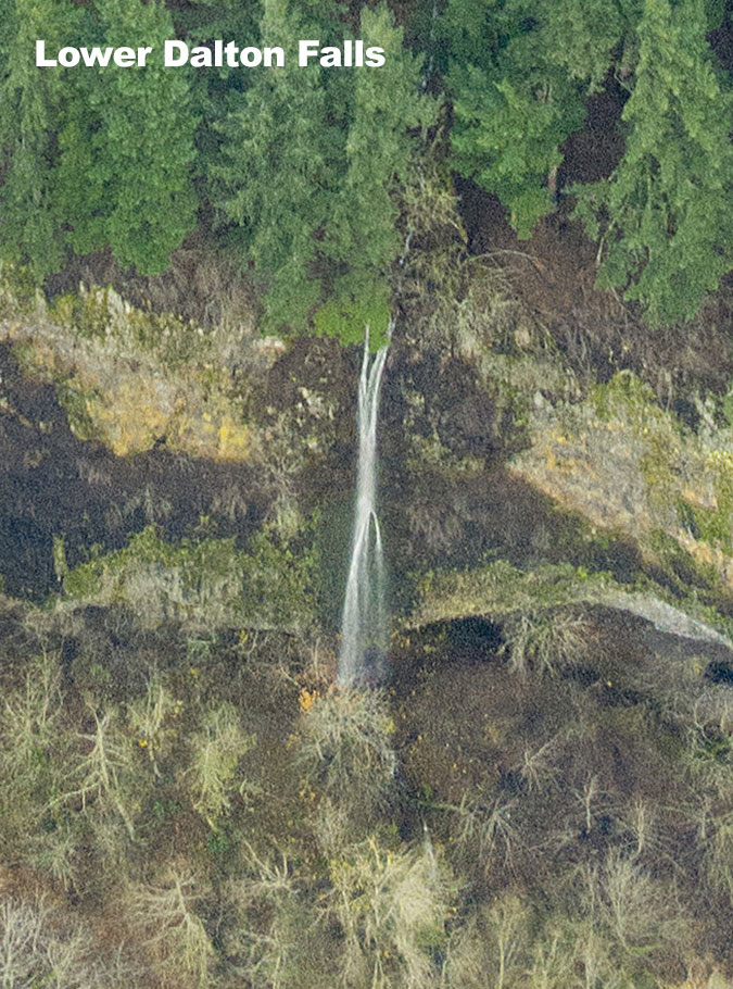
Just off to the left of the panoramic view is another falls on Dalton Creek. Lower Dalton Falls (below) is easily seen from the Historic Columbia River Highway, dropping from a cliff just west of Mist Creek, near a wide pullout on the highway.
So, there you have it — the “Heaven and Hell” waterfalls of the Columbia River Gorge. You might be able to glimpse them during the winter months from I-84 (so long as you’re not doing the driving!), but for the most part these are “hidden” gems… in plain sight!
What’s in a Name?
So, why map obscure waterfalls in the Columbia River Gorge? Party, because it’s fun and interesting to make new discoveries in places we think we know so well. But it’s also true that knowing (and naming) these places can help us better care for them and protect our public lands.
In recent years, a new generation of waterfall enthusiasts has uncovered hundreds of “new” waterfalls in the Gorge and throughout Mount Hood country. Part of this new era of discovery comes from new tools, like detailed satellite images and LIDAR mapping now freely available online. But finding these hidden gems still requires old-fashion exploring on the ground, ensuring that most of these off-trail waterfalls will continue to be known first-hand to just a few.

Scores of these “new” waterfalls are in places like the Clackamas River basin, where the forest is still recovering from brutal logging and road construction that swept through Mount Hood country from the 1950s through the early 1990s. Had we known these waterfalls (and so many other magical places) existed when industrial logging was underway on our public lands, would we have tolerated the massive clear cuts and logging roads that marred these beautiful places? Perhaps.
But it’s also possible that better public understanding of what was at stake might have slowed the bulldozers and chainsaws long enough to spare just a few of these places. These threats still exist for much of Mount Hood country, so long live the modern era of exploration and true appreciation for what is at stake!
___________________________

Postscript on COVID-19 from the author: we’ve all heard the words “unprecedented” and “challenging” too many times over the past few weeks, though both words do aptly describe our lives under a global pandemic. And with our public lands closed and Oregonians ordered to stay at home, you’ll be seeing few more articles on this blog.
However, I don’t plan to tie blog themes to the global health crisis in any way, as I’m quietly honestly enjoying the opportunity to focus on something other than the crisis. Hopefully that won’t seem disrespectful or insensitive to readers. That is certainly not my intent. Instead, I hope the blog can provide a temporary distraction from the truly “unprecedented and challenging” situation that we’re all struggling through, something I think we can all use.
As always, thanks for taking the time to stop by, and of course, stay safe!
Tom Kloster | March 2020

Nice info and good work again!
LikeLiked by 1 person
Thank you for the new education about the Gorge and it’s hidden falls as you graciously distract us from our quiet isolation. Hope to see you soon, healthy and happy.
LikeLiked by 1 person
Tom,
Thanks for sharing this. I’ve always wondered about Dalton Falls. When on Angel’s Rest, I can hear and see a waterfall across the canyon. I’ve always assumed this was Dalton Falls.
-Regis
LikeLiked by 1 person
Thank you Mark, Claudia and Regis! Appreciate you stopping by! 🙂
LikeLike
I think it was Ira Spring and Harvey Manning who, citing the “Fantastic Erratic” in the Issaquah Alps, said something to the effect, “The first thing you do in conservation is name things.”
LikeLiked by 1 person
Eric, our new Friends of Vista House Volunteer Coordinator is going to be a new and avid reader for your blog. What a grand resource it will be for his interest and energy! Thanks again!
LikeLiked by 1 person
Good go hear, Claudia! I’ve got a reference to Friends of Vista House in a piece I’m working on right now — thanks for all the good work you do! 🙂
LikeLike
Tom, that’s a great quote! Thanks! 🙂
LikeLike
Great groundwork once again, Mr. Kloster. It is interesting that almost right next door to Portland there are year-round waterfalls yet to be named! Thanks for the blog!
Jim Rhodes
LikeLiked by 1 person
Thank you, James! 🙂
LikeLike
Tom, this is great! I’ve always been curious about this stretch and all the slightly hidden falls. This is a great piece of writing. These blogs are always a welcome surprise in my inbox.
LikeLiked by 1 person
Thank you, Dan! 🙂
LikeLike
As a native born Oregonian… born in Hood River Hospital in 1947… I was delighted to come across your piece on Maples today. I quickly shared it with my friend David in Maine who has been unfamiliar with the Northwest’s bounty of maples. So glad to have found you and will be a follower… I live on the Olympic Peninsula now, a stone throw from the Strait of Juan de Fuca.
LikeLike