
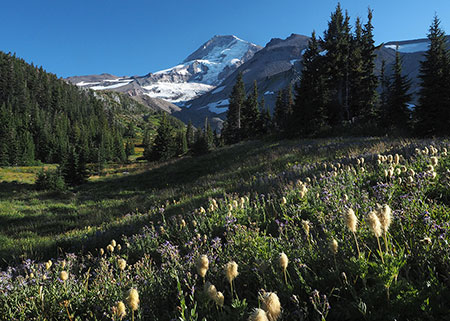
Mount Hood’s imposing west face is featured on the cover
[click here for a large image]
Each year since the Mount Hood National Park Campaign began in 2004, I’ve published a wall calendar to celebrate the many reasons why Mount Hood and the Columbia River Gorge should be our next national park. You can pick up this year’s calendar here:
2018 Mount Hood National Park Campaign Calendar
The monthly layout remains the same as last year, with a classic “grid” design that serves nicely as a working calendar for kitchens or offices. The finished calendar hangs 14 inches wide by 22 inches tall, with a white wire binding, and the print quality of the photos is excellent!

In the past I’ve used calendar sales help cover some of the modest costs of keeping the campaign website and WyEast blog up and running, but beginning this year I will shift to sending all proceeds to Trailkeepers of Oregon, and in turn, TKO’s coming efforts to help recover our Columbia River Gorge trails from the impacts of the 2017 Eagle Creek Fire.
The great thing about putting these calendars together is that it ensures I continue exploring new places in the gorge and on the mountain, as each calendar consists exclusively of photos I’ve taken over the previous year. In this year’s calendar article, I’ll provide some of the stories behind the photos in the new Mount Hood National Park Campaign Calendar — sort of a visual year-in-review!
The WyEast Year in Images
The following is a rundown of the 12 images inside the calendar by month, with a link to a large version of each image, too (you can see them by clicking the link beneath each preview image).
The 2018 calendar begins with the cover image (at the top of the article), featuring the steep Sandy Headwall on Mount Hood’s imposing west face. This is the view Portlanders have of their mountain from afar, but a close-up look from along the Timberline Trail reveals the crevassed Sandy and Reid glaciers tumbling down the slopes and the deep Muddy Fork canyon, almost directly below. This is Mount Hood’s “tallest” side, with a vertical rise of more than 7,000 feet from the Muddy Fork valley floor to the 11,250-foot summit.
The January image in the new calendar features a chilly Cold Spring Creek on Mount Hood’s east slope:

Cold Spring Creek in Winter
[click here for a large image]
Only a few years ago, the snowshoe hike along Cold Spring Creek to Tamanawas Falls was completely off the radar for most, but in recent years its popularity has soared, and the trailhead is now packed on winter weekends.
One twist this year was a Forest Service noticed tacked up at the trailhead:

Hmm…
As it turned out, what apparently was a difficult rock fall to negotiate over the summer was much easier to travel with a couple feet of snow covering the debris. The rocks fell in a section of canyon just below the falls that experienced an enormous cliff collapse in the early 2000s, and continues to be active.
For February, I selected a photo from a near-perfect winter day in the upper White River Canyon, along the popular Boy Scout Ridge snowshoe route:

Upper White River Canyon
[click here for a large image]
The day began with clear blue skies, which is glorious, of course, but not so great for photography. After reaching a favorite viewpoint in the upper canyon, though, bands of clouds began floating in, making for some memorable scenes of a cloud-framed mountain. The photo below was taken on the way out that day, as evening shadows began to stretch across the lower canyon.

White River and Mount Hood
[click here for a large image]
As covered in previous articles, fire in the Columbia River Gorge is as much a part of the ecology as the trees, themselves. But if you had told me the extent of the Eagle Creek Fire last spring, I wouldn’t have believed you.
For hikers, it’s almost like the Eagle Creek Fire was connecting dots among favorite Columbia River Gorge beauty spots, with only a few of the iconic waterfalls that make the Oregon side of the Gorge famous escaping the flames. So, even knowing and accepting that fire is a necessary and beneficial part of the ecosystem still doesn’t blunt the harsh reality that this fire felt personal. And it’s going to take awhile to heal.
As the fire raged west toward Portland last September, my immediate thought was Tanner Creek, the next drainage to the west of Eagle Creek and directly in the path of the inferno. If I had to pick a spot that embodies almost everything that defines the Columbia River Gorge, Tanner Creek’s lower canyon is it, culminating with spectacular Wahclella Falls.
This canyon is as fine a temple as nature can create, and it’s a sanctuary I visit many times each year. This is my most treasured place in the Gorge… and now I wondered “Would it burn?”

Wahclella Falls on Tanner Creek
[click here for a large image]

Waterfall enthusiasts visiting the altar at Wahclella Falls last spring
I didn’t know the answer to that question until a week or two ago, when I came upon some aerial photos of the Gorge taken sometime this fall. My scientific acceptance — embrace, in fact — of fire in our forests aside, I was selfishly relieved to see that the deep gorge surrounding Wahclella Falls had somehow been missed by the fire. Or had simply resisted it.
This photo shows Wahclella Falls and its iconic grove of Western Red Cedar mostly intact, though much of the surrounding Tanner Creek canyon was severely burned:

Wahclella Falls after the fire
Wahclella Falls is at the bottom of the photo, and Tanner Creek’s lesser-known upper gorge and the string of waterfalls that continue above Wahclella Falls can also be seen in this view. This is a place where I hope to see a trail, someday. Maybe in the destruction of the forest we’ll see new trails to places like this, where we take in new sights while also watching our Gorge recover?
For the March image, I selected another Gorge waterfall. This is the last in a string of waterfalls on Moffett Creek, located immediately to the west of Tanner, Creek. This falls is generally known as Moffett Creek Falls or simply Moffett Falls:

Moffett Falls
[click here for a large image]
This waterfall is off-trail, and requires walking a mile or so up the streambed of Moffett Creek to reach it. I first visited this falls in the early 1980s, and have returned several times over the years. Sometime in the late 1980s or early 1990s, a massive rock fall occurred here, and completely changed the landscape below the falls and the canyon slopes to the west.
Before the fire, the scene was already one of recovering forests, with young groves of Red Alder flanking the falls and lining the rearranged creek for 100 yards downstream. The Eagle Creek fire was just the most recent calamity to sweep through this spot, and such is the dynamic, often cataclysmic nature of the Columbia River Gorge.

Snowdrifts on Moffett Creek in mid-April!
Our trip last April was complicated by an extremely late snowpack, following a very wet and snowy winter in the Gorge. The canyon, itself, was a tangle of downfall from the harsh winter, making it a rough trip compared to previous years.
How did the fire affect Moffett Falls? Much more significantly than Wahclella Falls, on nearby Tanner Creek. Like Tanner Creek, Moffett Creek is located just west of Eagle Creek and was in the direct path of the fire during its most explosive, early phase. As this aerial photo taken sometime this fall shows, the entire forest around Moffett Falls appears to have been killed by the flames:

Someday, I hope to see a trail to Moffett Creek’s waterfalls, too. Who knows, maybe the changes wrought by the fire will allow the Forest Service to consider that possibility? It turns out this idea isn’t new, at all. In fact, it was proposed in January 1916, when the brand new (now historic) Columbia River Highway was about to open:

Excerpt from The Oregonian (January 30, 1916)

Map excerpt from The Oregonian showing the proposed Moffett Creek Trail (January 30, 1916)
More about that trail concept, and the need for a long-term trail plan for the Gorge in a future article…!
Did you know that today’s Silver Creek State Park has been proposed to become a national monument or park at least a couple of times in the past? It makes sense, given the spectacular concentration of waterfalls within this beautiful preserve, and especially with the legacy of trails and lodges left by the Civilian Conservation Corps (CCC) during their 1930s heyday. Many believe it to be a national park or monument today!
With this in mind, I selected a scene from a May visit to Silver Creek’s North Fork as a reminder that there are more than simply the show-stopper waterfalls to this amazing place:
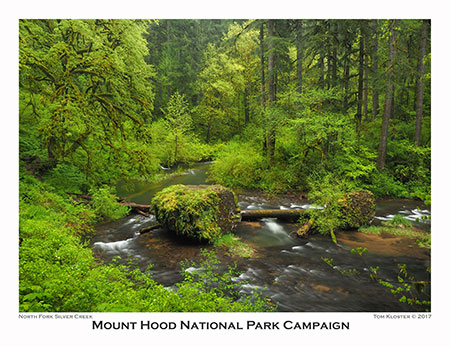
North Fork Silver Creek
[click here for a large image]
While our current regime in Washington D.C. is more focused on tearing away protections from our public in order to sell our resources off to corporate interests at bargain prices, it’s also true that the exploitation/conservation pendulum in our country swings both ways.
In some ways, the outrageous anti-environment, anti-science and anti-public lands extremism we’re seeing with the Trump administration has already kicked off a counter-movement. It can’t come soon enough, and hopefully you’ve joined in the opposition, too.

Misty Silver Creek Forest
Someday, when the pendulum does swing, Silver Creek would make an excellent unit of a future Mount Hood National Park. Why? Because the current park contains just a small slice of Silver Creek’s larger ecosystem, and today’s beautiful scenes of waterfalls and mossy glades are increasingly threatened by upstream development and industrial-scale logging. Watch for a future article on this topic, too!
While on the subject of threatened places, the June image in the 2018 calendar captures another such spot on the other side of Mount Hood: Bald Butte, located along the east wall of the Hood River Valley:

Mount Hood in late May from Bald Butte’s sprawling meadows
[click here for a large image]
This lovely butte rises directly above the Hood River Ranger Station, so close that Forest Service workers can enjoy the expansive wildflower spectacle from their offices, about a mile-and-a-half away as the crow flies, and some 2,200 vertical feet below.
You’d think being at the Forest Service’s front door would give pause to those who view our public lands as their personal playground to destroy. But Hood River County has a lot of off-highway vehicle (OHV) enthusiasts, and some in that community make a point of illegally driving their jeeps, quads and dirt bikes up the fragile slopes of Bald Butte — despite prominent signage prohibiting their use and periodic efforts to block them.
This is an ongoing battle with rogues that will someday be won, but it will take the OHV community policing itself to make the change happen. There will never be enough Forest Service crews to fill that void.

Growing OHV damage to Bald Butte
How bad it is? Well, the old lookout track that serves as the hikers trail to the summit has become deeply rutted by illegal jeep and motorcycle users, which in turn, has inspired them to form parallel tracks on the open wildflower slopes (above). It will take decades for the damage to recover, even if the law breakers were stopped today.
Meanwhile, dirt bikers have hauled in chainsaws in order to carve new trails through the forests on the east slopes of Bald Butte. It’s not a pretty picture, and so far, nobody in the OHV community seems to be stepping up to confront the lawlessness.

Dirt bike tracks don’t lie…
The Forest Service has indicated an interest to work with trail organizations (like TKO) to step up the efforts to keep OHV vandals out of Bald Butte, but in the meantime, they’re doing a lot of damage — which, in turn, is a black eye for anyone who enjoys using OHVs responsibly. Let’s hope they will join in the effort to protect Bald Butte, too.
For more about Bald Butte, and comparison photos that show the rapid progression of the OHV damage there, please see this earlier article on the blog – you can read it here.
For the July calendar image, I picked this 3-part composite of the Muddy Fork and Mount Hood. Look closely and you can see the series of towering waterfalls that drop from the hanging valleys on Yocum Ridge, in upper right. This is one of Mount Hood’s most rugged and untamed spots:

Mount Hood’s Muddy Fork canyon
[click here for a large image]
Though we had a decent snowpack in the Cascades in 2017, it melted fast when summer arrived, and many trails on Mount Hood’s west slopes were opening by late June. So, when college friends David and Robin, from Colorado, called to say they would be in Portland and wanted to spend a day on the mountain, the hike to the Muddy Fork Crossing was the perfect choice!

Old friends and The Mountain
It turned out to be a bluebird day, but what I found most interesting as we caught up on our parallel lives was their reaction to being in Pacific Northwest alpine country, again. Though David grew up here, he still marveled at the magnificence of our forests, especially the huge Noble fir groves we passed through, and Robin was especially taken with the amount of water, everywhere!
It was a timely reminder for me to never take our unique ecosystems for granted. Colorado has more big peaks than most any state of the country, but we are unique in our abundance or water and the verdant landscape it brings, from our rainforests, streams and lakes to the glaciers that hang from our peaks.
As we head into the uncertainty of climate change in coming decades, we’ll need to learn to view these seemingly abundant resources as precious and threatened, and no longer something to take for granted.

Finally!
Another surprise along the hike was a new sign — finally! — marking the well-trod “cut off” that shortcuts the Timberline Trail where Bald Mountain (not to be confused with Bald Butte) meets McGee Ridge. I’m sure there was some official slight-of-hand required for the Forest Service to post this junction, as it is simply a user trail, and thus unsanctioned. But it’s a good call that will help hikers better negotiate the maze of trails in this area.
For August, I selected a photo from a favorite meadow perched along a ridge I call the White River Rim. A fragile island of Whitebark Pine, Mountain Hemlock and Subalpine Fir groves grow here, hemmed in on both sides by deep, perpetually eroding canyons of loose sand and boulder.

Lupine fields on the White River Rim
[click here for a large image]
To the east of the rim is a maze of deep ravines that make up the White River Canyon. As the White River continues to cut into the loose volcanic slopes, here, whole sections of the ridge-top forests and wildflower meadows perched on the rim slide into the canyon.
The Salmon River is gradually eroding the rim from the west, as well, though less voraciously than the White River. In some spots, the flat ridge top is just a few feet wide, and losing ground fast. This is one of the most dynamic areas on the mountain.
The image below is also from along the rim above the White River, looking south and away from the mountain. This view captures the skeleton of a magnificent Mountain Hemlock and its still-surviving grove companions:

Sentinel Whitepark Pine on the White River Rim
[click here for a large image]
Mountain Hemlock often growth in tight, circular groves, and I suspect botanists will someday discover that these groves communicate in some way as part of their collective strategy for survival, just as Douglas Fir are now known to communicate. Forest ecologist Suzanne Simard summed it us this way:
“I wondered, could Douglas fir recognize its own kin, like mama grizzly and her cub? So we set about an experiment, and we grew mother trees with kin and stranger’s seedlings. And it turns out they do recognize their kin.
“Mother trees colonize their kin with bigger mycorrhizal networks. They send them more carbon below ground. They even reduce their own root competition to make elbow room for their kids. When mother trees are injured or dying, they also send messages of wisdom on to the next generation of seedlings.
“So we’ve used isotope tracing to trace carbon moving from an injured mother tree down her trunk into the mycorrhizal network and into her neighboring seedlings, not only carbon but also defense signals. And these two compounds have increased the resistance of those seedlings to future stresses. So trees talk.”
Botanists once viewed a dying or dead tree in a grove like this as one whose biomass had grown too large to support in drought periods, but could another explanation be that the larger tree simply opted to turn over the future of the grove to its younger siblings? We still have so much to learn from our forests…
The September image in the new calendar captures an intersection of three threads of good fortune: an afternoon away form work to visit the mountain, clear weather after an early autumn snowstorm and moonrise over Illumination Saddle, the narrow ridge that connect Illumination Rock to the main summit ridges of Mount Hood.

Moonrise over Illumination Saddle
[click here for a large image]
Time off from work on a clear autumn day was by design, but the moonrise was pure luck. While there are web tools for figuring out celestial paths from any point on the ground, I do confess that I’m not likely to use them. I simply sat at a favorite spot on the summit of Bald Mountain (not Bald Butte!) for an hour or so, waiting for the sunset, and was suddenly treated to the moon emerging over the saddle as an unexpected surprise!
So, why not use the modern tools? Partly, it just seems like a chore in what should be an enjoyable hobby. But I’d also be turning what was a wonderful surprise into one more thing to worry about — and that’s not why I head into the woods, after all. There’s something to be said for turning over the keys to Mother Nature, right?
And on that point, perhaps the best memory from that cold evening on Bald Mountain last fall was watching the sun set through the trees on the hike back down through the ancient Noble Fir forest.
Winter sunset in the Noble forest
This grove of 300-year old giants somehow escaped the chainsaws when the Clear Fork valley, below, was logged in the 1960s, 70s and 80s. It remains as a rare reminder of what used to be — and what will be again, if we allow it.
For the October image, fall colors were in order, and with the Gorge trails mostly closed by the Eagle Creek Fire, I headed south to Butte Creek, located just north of Silver Falls State Park in the Santiam State Forest. I picked a serene scene along the creek…
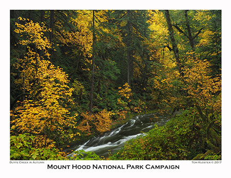
Butte Creek in autumn
[click here for a large image]
…though this peaceful spot is just 100 yards or so above Butte Creek Falls, which was raging that day, after a series of Pacific fronts had rolled through.
Butte Creek Falls is among my favorites, anywhere, and I’ve included it in past calendars. So, thus the quieter stream scene for 2018, but here’s a look at the high water at the falls that day:

Butte Creek Falls
[click here for a large image]
Even more than nearby Silver Falls State Park, the Butte Creek canyon (and its twin, Abiqua Creek, just over the ridge) is in desperate need of a better management vision, and would make for an excellent extension of a future Mount Hood National Park. More about that in a future article, as well..!
Though I’ve hiked the short loop trail at Butte Creek many times, the fire in the Gorge had forest ecology and the role of fire in my mind on this visit, and noticed a small army of “legacy trees” throughout the rainforest here.

The skeletons of Butte Creek’s “legacy trees” are hiding in plain sight
These ancient stumps and snags are from the last big fire to come through the area are called “legacy trees” for the benefits they bring from the old forest to the new. This area likely burned more than a century ago, yet the skeletons of the old forest still serve a crucial role in the health of the new forest.
As they slowly decay, old snags and stumps provide habitat for birds and other wildlife, and once fallen, they become “nurse logs”, upon which new trees grow. They also provide nutrients to the precious mountain soil as they decay — something a log hauled off to become lumber or cardboard can never do.
For November in the new calendar, I selected an image from the upper Hood River Valley, with Mount Hood rising above fields owned by a family that has continuously farmed the valley since the 1800s. On this day in late October, the Cottonwood grove at the center of the photo was in peak form, and the fresh coat of snow on the mountain was softened by a light haze in the air from farmers burning orchard trimmings.

Upper Hood River Valley in autumn
[click here for a large image]
But this wasn’t my first attempt at the photo! As shown below, I’d stopped here a couple of weeks earlier, after another early snowfall had blanketed the mountain. At that point, the Cottonwoods were still in their summer green, but what a different two weeks makes! I’ve cropped images from both visits identically for comparison:
Hood River Valley scene in mid-October…

…and two weeks later!
Notice how much sharper the mountain was on the earlier visit? It could have been wind conditions sweeping away smoke from orchard fires that day, or perhaps the burning season hadn’t begun, yet? Nonetheless, I liked the depth created by the haze in the second view, too.
For the December image, I picked this view of Tamanawas Falls on Cold Spring Creek, captured the same day as the opening photo of the creek in the January image. This is always a magical spot, but I’ll share a couple of details about the trip that made the day memorable.

Tamanawas Falls on Cold Spring Creek
[click here for a large image]
First, it’s always an icebox in Cold Spring Canyon in winter. Why? Because the low sun angle in winter months can’t reach the canyon floor due to the steep terrain in all directions. So, while the above image looks like it was taken on an overcast day, the view straight up was of a bright blue sky.
The image below shows the cliff section where the recent rock fall occurred, and you can see that the trees on the canyon rim are basking in sun and have shed much of their snow.

Sunshine above, icebox below…
For slow shutter speed waterfall photographers (like me), this icebox canyon effect means a perpetually cold canyon in winter, but also very good photo conditions. There is one exception to the shady icebox, and that’s when the sun very briefly finds its way through the upper canyon of Cold Spring Creek and lights up the top of the falls for a few minutes. Here’s what that looked like on a trip in 2015:

Patience pays if you want to catch the winter sunburst at Tamanawas Falls!
The other story behind this photo is found in the following image. The black metal wand is actually part of a tripod leg (and possibly a piece of my pride, too) that snapped off when I took a fairly long, unscheduled slide down the ice-covered slopes near the falls that day.

Winter gear, somewhat intact…
My mistake was trying to get a little too close for a different angle on the falls, and my humility was only magnified by the fact that a young snowshoeing family watched the whole thing unfold in front of them. As I pretended to calmly fold up my mangled tripod as if it were all a planned event, I overheard their young son say to his parents “Woah! Did you see that man crash and burn??” Yes, I’m afraid everyone did..!
The Zazzle calendar format I’ve been using for the past couple of years also offer a back page, so I’ve continued to use that for wildflower photos that otherwise wouldn’t make it into the calendar.
From the top left for the 2018 calendar, reading right, they are Arrowleaf Balsamroot, Mariposa Lily, Oregon Sunshine, Bicolor Triteleia, Paintbrush, Lupine, Tiger Lily, Larkspur and Bleeding Heart:

[click here for a large image]
That’s it for the 2018 calendar, but what about the photos I couldn’t fit in..?
One that didn’t make it…
Elk Cove on Mount Hood’s north side
[click here for a large image]
I’ve made at least one trip to Elk Cove every summer for as long as I can remember, and have a particular spot that I always shoot from (though I also try new spots each year, too!). It’s a favorite scene, but has also been in many calendars in past years, so Elk Cove is taking the year off from the 2018 calendar.
But worse, it seemed like bad luck to use this photo, given the somewhat scary tumble I took on the way back to the trailhead later that day.
It began with staying too late on the mountain for that gorgeous early evening light, then getting waylaid on the way down the Vista Ridge Trail trail by (more!) plump huckleberries. I filled another water bottle, then hoofed it at high speed in the growing darkness, hoping to avoid digging that annoying headlamp out of my pack.
That was my final error. Just 3/4 mile from the trailhead, where the Vista Ridge Trail crosses a rocky, dusty section in the Dollar Lake Burn, I tripped on a particularly sneaky rock and went airborne, crashing into the base of a bleached snag. Fortunately for my head, I had put my arm out ahead of me in the fall. Unfortunately for my arm, it took the brunt of the blow.
It hurt a LOT, and I just laid there for a moment, trying to figure out if I was seriously hurt. Nope, all parts seemed to be functioning… except better my better judgment, of course!

Ridiculous… but functional!
What followed was a frantic search, first for my tripod (which I had hurled into the ravine below the trail during the fall), then in my pack for my headlamp (where WAS it?) as my right forearm ballooned up to alarming dimensions. Then came a very long 3/4 mile down the trail to the car.
Once there, I was further chagrined to see that I was, in fact, the last person on the trail that day… more humble pie on the menu! Fortunately, I wasn’t more seriously injured in the fall, or worse, knocked unconscious. Gulp. I ran through a list of the emergency supplies I keep in my pack in my mind…
Meanwhile, my bloated arm was now turning purple, so I turned an extra boot sock into a makeshift wrap and packed a couple of ice bricks from the cooler. I feared a broken arm — after all, I’d broken this arm twice as a kid (don’t ask). The long drive down the mountain was “interesting” without the benefit of an opposing thumb on my sore arm, and I let out a big sigh of relief when I finally arrived at home later that night.

The radiologist remarked on my unusually curvy bones, courtesy a pair of childhood breaks… but no break this time!
X-rays a few days later confirmed that I just had a very deep bruise (to both forearm AND pride, it turns out), and several weeks of alternating hot and cold packs followed as things gradually got back to normal.
But MORE importantly, I was able to return to the scene of the crash a couple weeks after the event and recover my tripod — yes, the tripod I purchased to replace the one I smashed at Tamanawas Falls!
Here are a couple of schematics that tell the embarrassing story:

The scene of the crash…

…and my poor tripod!
The Elk Cove trip was my most painful fiasco of 2017, but not the only one over the past summer. The other would belong to…
…an epic eclipse fiasco!

Recon data for the eclipse!
You may have heard: we experience a total eclipse in WyEast Country last August! I thought long and hard about setting up camp somewhere south of Mount Hood, in the path of totality, but having taken just one day off work, decided to avoid the predicted crowds and traffic jams (which did happen!)
Instead, I set up at my beloved Owl Point, on the north edge of the Mount Hood wilderness, and just outside the path of totality (as shown in the map, above). I’m not sure what I expected, but I came prepared with two cameras and two tripods (below) to document the scene at five-minute intervals. I left home at 5 AM and was on the trail by 7:30, anticipating great things!

Dual camera setup, weird light underway
It did turn out to be a memorable experience, but certainly not the beautiful spectacle I had imagined.
First, the strange light during the eclipse was not really pleasant — more just weird and eerie. It made sense to me later, that simply blocking out the sun mid-day would create a cast more like what we see when there’s heavy forest fire smoke in the atmosphere — harsh reddish-yellow — as opposed to the soft colors we see at sunset, when the sun’s rays are filtered through a lot more atmosphere.
I also learned what the scientists had been telling us: that even with near totality, the sun is blindingly powerful, so from this point just outside the path of totality, it was more “dimmed” than “dark” outside. That said, the birds did go quiet, as advertised. That part was surprisingly creepy.
While I plunked away at intervals with my big cameras, I also captured a few with my phone — including this panorama as totality approached. An eerie scene, yes, but what really jumped out is that I also captured the image of the sun in the lens reflections. I’ve enlarged a section, below:

Just short of totality… note the blue dots!

Close-up of blue dots reveals the to be reflections of the eclipse in the camera lens!
The following views capture the scene just before and during totality from Owl Point:
The view from Owl Point just before totality… weird!
The view from Owl Point at totality… kinda creepy!
What I found most interesting (beyond the weird colors) is that I could see the far side of the path of totality over the west shoulder of the mountain during totality. That gave me the best sense of what the event was all about, and I was glad to have experienced it, though it was definitely not what I was expecting. Just a very interesting experience.
On the way out that day in August, I took the opportunity to pick a water bottle full of plump huckleberries, and also some time to reflect on my place in the universe. I had lost a close family member in July, and a day alone on the mountain was just what I needed to sort out my feelings and replay some good memories in my mind.

Tasty consolation prize!
The mountains are great for that sort of thing, and we’re so lucky to live in a place where we have that luxury right in our backyard.
And the huckleberries? They were converted into tasty muffins the next day!
Looking ahead to 2018
I’m looking forward to posting a few more articles in the coming year than has been my recent pace. There’s a lot to cover on the WyEast beat, and I’ll be refocusing my volunteer efforts a bit more on advocacy this year, including this blog.
The Eagle Creek recovery effort will be a recurring theme, of course. There is so much to learn from the fire, and there are many crucial choices ahead for land management, too. In particular, I’ll be weighing in on a few topics that I think our non-profit advocates have a blind spot for, or perhaps are shying away from.

The author at Abiqua Falls a week or so ago…
Most importantly, I’ll spend as much time as I can out in WyEast Country, exploring, documenting and celebrating our precious public lands. As always, thanks for reading the blog, and I hope to see you out there, too!
See you on the trail in 2018!
Tom Kloster
WyEast Blog

Merry Christmas Day! Thanks for your post late last night. When I tried to access the calendar order page this morning, I couldn’t find it.. You may want to check it (again, I would guess). Enjoyed your annual review/preview. Happy holidays! Bruce
Sent from my iPad
>
LikeLike
Thanks, Bruce! And thanks for catching the dead link — should be working now. Happy holidays to you, too!
LikeLike
I always look forward to your blog entries, Tom. This was a great review of the year with wonderful photos. I’ll order a calendar. Thanks so much for all of your work on behalf of TKO and for all Oregon hikers.
LikeLike
What wonderful photos! Thanks for sharing them and the stories.
Do you know how Elowah Falls and the canyon fared? That is my temple in the Gorge.
LikeLike