
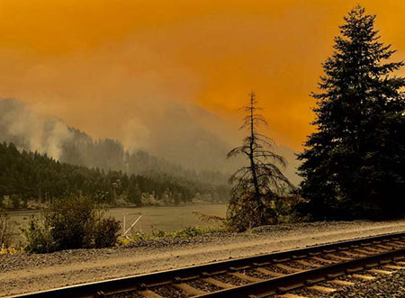
Eagle Creek Fire during the initial, explosive phase (US Forest Service)
Officially the Eagle Creek Fire in the Columbia River Gorge is still fully involved, now at 35,000 acres and just 10 percent contained by firefighters. Rain in the forecast for the coming week suggests that the fire will continue to slow as October approaches, and our attention will turn toward the changes that fire has once again brought to the Gorge.
The Gorge is a second home for many of us, and in some ways the fire was akin to watching our “home” burn. But that’s a human perspective that we should resist over the long term if we care about the ecological health of the Gorge. Fire is as natural and necessary as the rain in this amazing place, though that’s a truth that we have been conditioned to resist. I’ll post more on that subject in a subsequent article.
Surreal Gorge landscape under smoky skies from the Eagle Creek Fire (US Forest Service)
For now, we’re just beginning to learn about the impact of the fire, even as it continues to burn. Thankfully, no lives have been lost, no serious injuries reported and very few structures have been lost. That’s a testament to our brave emergency responders (many of them volunteers) and the willingness of most Gorge residents to abide by evacuation orders. It has surely been a frightening and stressful time for those who call the Gorge home.
The impact on public lands is still largely unknown, but the Oregon side of the Columbia River Gorge has one of the most concentrated, most heavily used trail systems in the world, and the damage to trails is likely to be significant. The Forest Service is likely to close affected trails for months or even years in order to assess the damage and determine how best to restore them.

1930s hiker at a viewpoint along the Perdition Trail (with Multnomah Falls beyond)
If you’ve lived here for awhile, you’ll also recall that we lost the Perdition Trail, an iconic, prized connection between Wahkeena Falls and Multnomah Falls, to the 1991 Multnomah Falls Fire. The reasons were complex, and it will tempting for the Forest Service to let some trails go, given their shrinking trail crews. We should not allow this to happen again.
Every trail should be restored or re-routed, and new trails are also needed to spread out the intense recreation in the Gorge. Trails advocates will need to work together to ensure this. Trailkeepers of Oregon (TKO) has set up a mailing list dedicated to Gorge trail restoration, if you’re interested in working on future volunteer projects. You can sign up for periodic updates and events here.
______________________
On September 10, I drove SR 14 on the Washington side of the Gorge for my first look at the fire, starting in Hood River. Below each of the following annotated photos, I’ve linked to much larger versions that I encourage you to view if you’re reading this on a large monitor, as they provide a better sense of the fire’s impact.
As hoped, much of the burn is in a patchy “mosaic” pattern, a healthy and desirable outcome for the ecosystem. This is how fires used to occur in our forests, before a century of suppression began in the early 1900s. Mosaic burns allow for mixed forest stands and exceptional wildlife habitat to evolve, even as we might mourn the loss of familiar green forests.
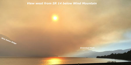
The wind pattern on Sunday had shifted from westerly to a northwesterly direction, producing a bizarre effect: smoke from the fire hugged the vertical wall that is the Oregon side of the Gorge, while the Washington side was cleared of smoke and under a bright blue sky. The view, below, shows this split-screen effect from near Wind Mountain.
Moving west, the combination of ongoing wildfire and back-burning by firefighters was producing a continuous plume along the base of the Oregon cliffs, from Herman Creek east to Shellrock Mountain, as seen below. The Pacific Crest Trail traverses this section, and is undoubtedly affected by the fire.

From the Bridge of the Gods wayside, opposite Cascade Locks, the impact of the fire on the canyons that fan out from Benson Plateau is visible. Some areas (below) show a healthy mosaic burn, while some of the upper slopes show wider swaths of forest impacted. The alarming proximity of the fire to the town of Cascade Locks is also evident in the scorched trees visible just above the bridge in this view. This was a close call for those who live here.

Turning further to the east from the Bridge of the Gods wayside (below), the ongoing wildfire and back-burning shown in the previous photos can be seen in the distance, beyond the town of Cascade Locks.

The scene at the Bridge of the Gods bridgehead (below) is an ongoing reminder that we’re a long way from life returning to normal for Cascade Locks residents. For now, I-84 remains closed and this is the only route into town, and only open to those with proof of residency.

Moving further west, the 2000-foot wall of cliffs in the St. Peters Dome area that stretches from McCord Creek to Horsetail Creek (below) come into view.
Here, the fire has also burned in mosaic pattern, with many patches of green forest surviving. But the frightening effects of the firestorm that occurred in the first days of the fire is also evident, with isolated trees on cliffs hundreds of feet above the valley floor ignited by the rolling waves of burning debris that were carried airborne in the strong winds that initially swept the fire through the Gorge.

A second view (below) of the St. Peters Dome area shows the burn extending toward Nesmith Point, nearly 4,000 vertical feet above the Gorge floor.

Moving west along SR 14 to the viewpoint at Cape Horn, the impact of the fire on areas west of Horsetail Falls comes into view (below), along with a better sense of the mosaic pattern of the burn. This view shows the Horsetail Creek trail to be affected by the first, as well as the slopes on both sides of Oneonta Gorge.
In this earlier piece on Oneonta Gorge, I described the dangerous combination of completely unmanaged visitor access and an increasingly dangerous logjam at the mouth of the Gorge. The fire will almost certainly trigger a steady stream of new logs rolling into Oneonta Gorge and adding to the massive logjam in coming years.

Moving further west, the area surrounding iconic Multnomah Falls and Wahkeena Falls comes into view (below). As with other areas, the fire burned in vertical swaths along the Gorge face, leaving more mosaic patterns in the burned forest. From this view, trees along the popular 1-mile trail from Multnomah Falls Lodge to the top of the falls looks to be affected by the fire, as are forests above Wahkeena Falls.

This wide view looking east from above Cape Horn (below) shows most of the western extent of the fire, with the north-facing slopes of Angels Rest heavily burned, while the west and south-facing slopes were less affected.

A closer look at Angels Rest shows that the burned area in the current fire closely matches the area that burned in the 1991 (below), along with slopes on the opposite side of Coopey Falls. The Angels Rest Trail was heavily impacted by the 1991 fire, and will clearly need to be restored after this fire, as well.

I’ve marked an approximation of the 1991 fire extent at Angels Rest in this closer look (below) at the summit of Angels Rest, based on tree size. Tall conifers burned in today’s Eagle Creek fire survived the 1991 fire, and mark the general margins of that earlier fire.
Areas within the 1991 burn were still recovering and consisted largely of broadleaf trees, like Bigleaf and Vine maple. Depending on the heat of the fire and whether their roots survived, these broadleaf trees may be quick to recover, sprouting from the base of their killed tops as early as next spring.
The recurring fires at Angels Rest offer an excellent case study for researchers working to understand how natural wildfires behave in successive waves over time. This, in turn, could help Gorge land managers and those living in the Gorge better plan for future fires.

Finally, a look (below) at the western extent of the fire shows a few scorched areas in Bridal Veil State Park, including the forest around the Pillars of Hercules. Bridal Veil Canyon appears to have escaped the burn, though some trees near Bridal Veil Falls may have burned.

I’ve titled this article as my “first look” because the story of the Eagle Creek fire is still being written. Only after the fall rains arrive in earnest will we have a full sense of the scale of the fire.
As new chapters in the Eagle Creek saga unfold, I’ll continue to post updates and share perspectives on this fire and our broader relationship with fire as part of the natural systems that govern our public lands. With each new fire in close proximity to Portland, we have the opportunity to expand and evolve how we think about fire, and hopefully how we manage our public lands in the future.
More to come…

Your post here has exactly the details I wanted to see! I drove through the Gorge twice in the last 3 days out of necessity and wasn’t able to take quality time to stop and look. I really appreciate all the labeling. I can pick out a few features but wish I could name all that I’m looking at. Thank you! Will eagerly watch for more.
LikeLiked by 1 person
Thanks for pointing out that fire has always been part of our PNW forests. Yes, the landscape we were familiar with has been altered but remember we had the same feeling of loss after the 1980 eruption of Mount St. Helens. Consider how amazing it has been to watch and learn from the natural recovery of that area; we have the same to o look forward to in the Gorge! The mosaic of green, unburned areas among burned areas will help speed the recovery of vegetation.
Right on – we must NOT allow ANY LOSS OF TRAIL MILEAGE AFTER THE FIRE!!! WE need to keep the pressure on the Forest Service and Congress to make trail restoration a funding priority.
LikeLiked by 1 person
Excellent source of information. Thank you for taking the time. I was just curious if you know the name of the mountain in the background of the photo titled “Bridge of the Gods at SR 14”. It seems very prominent in the city, but I cannot seem to find a name.
Thank you
LikeLiked by 1 person
@Doug, that is an unnamed (but rugged!) ridge that leads up to Benson Plateau from the Historic Columbia River Highway. The Ruckel Creek Trail climbs the backside of it, but at one point pokes out at one of the notches for a tremendous view of Cascade Locks, a couple thousand feet below. It deserves a name, right? 🙂
@Russ, thanks for commenting and couldn’t agree more on the trails! Much more to come…
@Margi, thanks for reading! 🙂
LikeLike
I live in Michigan but spend summers in the Gorge windsurfing and hiking. This summer I hiked just about all the trails affected by this fire. Thanks so much for the excellent photos and details. It will never be the same, but change is a fact of life.
LikeLiked by 2 people
I am quite horrified at the suggestion that the trail system to be expanded to meet the increasing demand of people who live in Portland. The gorge may be a “second home” to Portlanders and other outsiders, but for the residents of Corbett, Cascade Locks, and Hood River, it is our first and only home. You are all outsiders. I remember what the the Gorge was like before it was strewn with broken glass and used condoms from Portland people who saw the pristine wilderness as their personal playground. MANAGE AND RESTRICT ACCESS TO THE GORGE. If the people of Portland demand the right to fill up our sacred spaces with their dog’s feces, they should pay dearly for it.
LikeLike
USFS. I worked ‘trail crew’ in the Southwest for the FS. Funding was minimal and we covered a large area. It was seasonal work. We were all experienced and dedicated to our task. With all the money the federal government garners through taxes, funding adequate trail crews requires a minuscule amount of cash from a big fat budget dedicate to numerous questionable activities (count those as you wish). The emphasis on ‘volunteers’ is ludicrous, no matter how laudable, there is plenty of funding to dedicate to hiring dedicated experienced individuals or training crews. The means to applying public pressure to provide such resources is difficult to muster, but should be encouraged. There is a lot of work to be done.
LikeLiked by 1 person
I would agree with that, “Raoul” — in the long term. Right now, the fact is that Gorge trail crews are about one third of what they were as recently as the early 1990s. That’s a result of budget priorities in Washington DC and within the USFS. So, until we turn those ships, volunteers are all we’ve got to stem the tide.
@Dia Holly — public lands are owned by all of us, so I respectfully disagree that anyone is an “outsider” in the Gorge. Not everyone has the luxury of owning a private slice of what I would agree is a “sacred space”, and trails are one of the best ways for all to appreciate the Gorge, no matter their financial means.
LikeLiked by 1 person
Excellent, informative article with a long-term perspective. The photos very helpful, too.
Once again, WyEast lives up to long-time traditions of good stewardship.
Robert Kanzler Lancefield
LikeLiked by 1 person
Thank you, Rob!
LikeLike
Yes, fire is a natural occurrence and dryer summers have resulted in more and larger fires. However, the Eagle Creek fire was an entirely avoidable human caused fire. This fire has a clear cause (idiot teens throwing fireworks off a cliff into dry brush on the Eagle Creek Trail). Important to keep this fact in mind, the devastation caused by these foolish young arsonists (who had started previous fires in natural areas) and suffering were not the result of natural forces (unless you include Climate Change).
Hoping these foolish teens and their parents are held accountable. It won’t bring back the Gorge, but appropriate justice
might deter others from repeating their actions.
LikeLiked by 1 person
Thank you! Very good interpretation from a knowledgeable person.
LikeLike
Thank you so much for this extended information and regarding
the gorge fire. I loved my time driving thru it a number of years ago.
I loved it and found it spectacular. I’ve never been able to forget
the beauty even from the road.
LikeLike
This is a really useful and welcome overview. Thanks! I’m hoping we learn some lessons from this, and perhaps that it becomes a turning point for better management of the Historic Highway area. Like many people, I feel the conflicting desire for better infrastructure to deal with the increasing usage and the realization that perhaps we need less people out there which would likely be accomplished through a fee system.
Either way, I hope we don’t lose too much trail access and that when it’s safe, people are able to get out there and watch it regrow over the next few years.
LikeLike
The public lands in the Gorge belong to the citizens of this country. Some individuals are lucky to own private property in the Gorge. The problems described above are from a few people who, unfortunately, never learned to respect nature, nor the rights of others. Please, do not paint all of the public as careless because of a few individuals. Many of us carry our trash out responsibly, and pick up after our dogs.
Great photos and information. Suprression of wildfires has set us up for conflagrations, and we pretty much lucked out this time.
Inasmuch as most of us did stupid things as teens, isn’t it reasonable to consider this a natural occurrence as well as a human-caused fire?
LikeLike
It’s been hard to find such informational pictures and updates. My friends and I have been hiking this area extensively for 30+years and know just how special it is. It of course is a lost to the way it once looked but hope that in time it will rebound and become special again. God bless for your time to inform us.Jerz
LikeLike
JP Moore: Human idiocy and white male privilege are certainly natural occurrences in our country, but let’s not malign Mother Nature in this. It is vital to the future protection of our Gorge to acknowledge that this was a human-caused fire. Actions NEED to be taken to prevent ANYONE from playing with fireworks in our public lands and forests. While many fires cannot be prevented, this one could have been entirely prevented- and any speculation of whether another devastating fire of this scope could have occurred in the Gorge naturally is entirely speculative and beside the point at hand. Those culpable include the dimwitted teens playing with smoke bombs in a forest in the peak of a dry season during a burn ban, their negligent and complacent parents, the vendors who sold them the smoke bombs, and our society that benignly pats our boys on the back and says “boys will be boys” when we should be saying “enough is enough.” If these children were old enough to drive a vehicle without parental supervision and to set off smoke bombs without parental supervision, they’re old enough to realize and understand the scope of their actions. We need to teach our children to be good stewards of the earth, not to be little sociopaths who like to film themselves making things go boom! and then laughing as they burn.
To the original poster: thank you for sharing your photos. It’s so hard to see the Gorge like this, but among the charred sticks it’s encouraging to see the green scattered throughout.
LikeLike