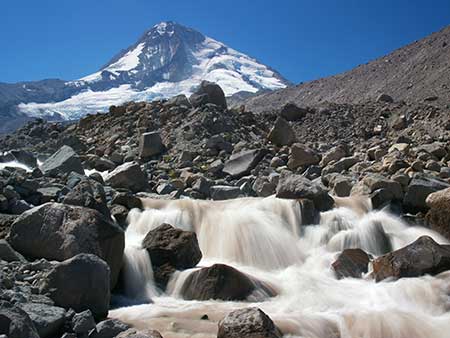
Eliot Branch and Mount Hood before the 2006 washout
Another hiking season has passed, marking eight long, inexcusable years since an intense November storm washed out the Timberline National Historic Trail near Cloud Cap in 2006.
Since then, countless hikers from around the world have arrived at this world-class destination only to find cryptic temporary notices stapled to trailhead signs announcing that the segment of the trail crossing the Eliot Branch has been closed indefinitely by the U.S. Forest Service.

Hikers on the seasonal bridge over the Eliot Branch that was in place from the mid-1990s until 2006
Most round-the-mountain hikers start at Timberline Lodge and hike clockwise, and therefore often learn of the Eliot Branch closure halfway through their 40-mile trek. Understandably, many of these hikers began working their way across the deeply eroded canyon in the years following the closure. Today hundreds of hikers each hear ignore the Forest Service notices and follow sketchy boot paths across the Eliot Branch to complete the Timberline Trail circuit.
Why the delay in repairing the trail at the Eliot Branch? The Forest Service claims lack of funding, suggesting in 2010 that “studies were underway” for a million dollar suspension bridge at the current crossing location. Such a project would “require an appropriation by Congress” to fund, according to a Forest Service district ranger at the time.
A second, more practical option under consideration was a significant reroute of the Timberline Trail at the Eliot Branch, which according to the Forest Service at the time, would require “constructing 1.5 miles of new trail to a lower crossing of the creek, then 1.5 miles back up to the existing trail”.
Eight years have passed since the 2006 washout, and four since the Forest Service last gave any indication of working toward a solution for the Timberline Trail. Since then, neither option proposed in 2010 for restoring the crossing has materialized. Instead, Oregon’s premier hiking trail remains an embarrassment, and a testament to the frustrating inability of the Forest Service to set agency priorities that match those of the public they serve.

These seasonable bridge footings were bolted to a pair of huge boulders that were swept away in the 2006 washout
The 2006 flood event wasn’t the first time the Eliot Crossing had washed out in recent years. In the mid-1990s, a similar washout erased an earlier crossing that had been in place since the Timberline Trail was constructed in the 1930s. The Forest Service responded to the first washout by appropriating sections of a pair of climber’s trails that ascend moraines on both sides of the Eliot Canyon, and constructing a new crossing between the two trails, above the original crossing.
This new crossing (pictured above) lasted only a few years, until the 2006 storm further deepened the Eliot Branch canyon, this time much more substantially. The new crossing featured a pair of bridge anchors bolted to boulders that straddled the Eliot Branch, and a seasonal bridge that could be reassembled and installed on site each year, similar to the Sandy River bridge near Ramona Falls.

The sorry state of the “closed” Eliot Branch crossing today: a sketchy scramble up a crumbling 300 foot slope, aided by a rope left by hikers
Removable, seasonal bridges are an excellent solution to the dilemma of keeping the Timberline Trail open in an era when retreating glaciers and increasingly erratic weather promises to continue deepening all of Mount Hood’s newly exposed glacial valleys.
This point was underscored earlier this year when an unusually strong summer storm washed out the seasonal Sandy River crossing. While one hiker was tragically killed in the incident, dozens were able to cross to safety because of the seasonal bridge.
For this reason, studying elaborate permanent solutions, such as the “million dollar” suspension bridge, are an exercise in futility. Whole sections of the Eliot Branch canyon have collapsed into the stream over the past two decades during heavy flooding, and there is no reason to assume that this pattern won’t continue to rearrange the landscape for decades to come.
This article proposes a more modest and immediate fix that mirrors the re-route option once considered by the Forest Service. This is a project that could have been constructed shortly after the 2006 floods with minimal cost and an excellent ability to adapt to future flood events.
Lessons from Up North

Wonderland Trail bridge across the Nisqually River in Mount Rainier National Park (Wikimedia)
The Eliot Branch crossing is a perfect example of how the U.S. Forest Service and National Park Service differ in their budget priorities and working relationships with volunteers. It’s instructive to look at how the Park Service responded to the same 2006 storms and flooding that impacted Mount Rainier National Park.
The damage to the 92-mile Wonderland Trail around Mount Rainier was exponentially worse than anything on Mount Hood. This is largely because several of Mount Rainier’s 26 glaciers dwarf even the Eliot Glacier, Mount Hood’s largest, and the Wonderland Trail has three times the glacial stream crossings of the Timberline Trail.
The Wonderland Trail not only crosses many more glacial streams in its circuit around Mount Rainier, it also has bridges across most of them, where most of Mount Hood’s glacial streams have no bridges (requiring hikers to ford most of the glacial streams). So, not only did the Park Service have a trail more than twice as long to restore, but also many times the number of bridges to repair along the Wonderland Trail.
Despite the much greater challenge, the Park Service managed very little disruption for hikers. The Wonderland Trail uses a reservation system, and the Park Service took the precautionary step of not accepting reservations for the 2007 hiking season, in light of the scope of damage to many trail sections and crossings. Yet, the Wonderland Trail was reopened to hikers on August 3, 2007, less than a year after the 2006 floods!

The National Park Service continually maintains dozens of wilderness bridges on the 92-mile long Wonderland Trail around Mount Rainier, despite much worse washouts and much more difficult crossings than anything found on Mount Hood (Wikimedia)
The rapid repairs to the Wonderland Trail happened because re-opening the trail was a top priority for the Mount Rainier National Park. To manage this feat, the staff enlisted some 1,700 volunteers in the effort, with tens of thousands of volunteer labor from organizations like the he Washington Conservation Corps and Student Conservation Association.
The proposal described in this article for the Eliot Branch could easily have been completed in 2007, too, had restoring the trail been a priority for the Forest Service, and especially if volunteer labor had been tapped from any number of organizations involved in trail work in Oregon. Instead, the repairs have waited eight years, with no end in sight.
It’s time to finally fix the Timberline Trail to ensure the safety of hikers determined to make the crossing, and to end the embarrassment of visitors to our region from around the world experiencing this national treasure in such a shameful state of disrepair.
A Simple and Affordable Solution!

[click to see a large version]
The simplest solution to finally restoring the Eliot Branch crossing is to go lower and low-tech. Instead of waiting for a dubious “million dollar” suspension bridge to be funded, a better option would be a new crossing downstream with a simple, seasonal plank bridge.
Why go low? Mostly because the durable bedrock layers that form Stranahan Falls (located about a mile downstream from the current crossing) have also checked down-cutting of the canyon in that stretch by the Eliot Branch. Where the upper canyon has been carved some 150 feet deeper since the 1990s, the lower canyon section, just above Stranahan falls, shows much less erosion during this period.
As shown on the proposal map (above), this new section of the Timberline Trail would depart from Cloud Cap Saddle trailhead, initially following a shallow ravine to the rim of the Eliot Branch canyon. The new trail would then switchback down the east wall of the canyon, reaching the new crossing (shown below) about 0.5 miles from the start of the new trail.
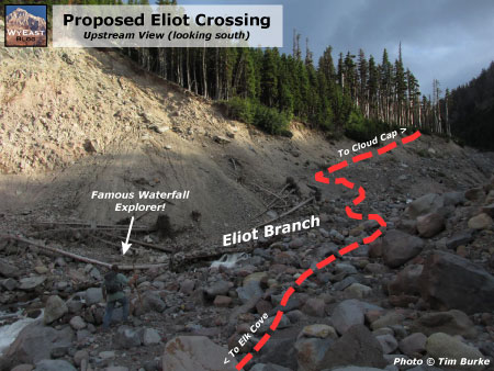
[click to see a large version]
The new, lower stream crossing would be similar to most other glacial fords on the Timberline Trail, except that a bridge is proposed here (as they should be at all glacial crossings on Mount Hood – watch for a future article on that topic!).
This is in part because a bridge has traditionally been provided at this crossing, but also because the crossing location is very close to the Cloud Cap Saddle trailhead, and located at the wilderness boundary, so it would present fewer obstacles to build and maintain. Until the Eliot Branch settles down, however (and that could decades from now – or never), it makes sense to install a season bridge similar to that used on the Sandy River.
From the proposed lower crossing of the Eliot Branch, the new trail would traverse along a side stream that enters the main canyon from the west, climbing approximately 0.8 miles to the resumption of the existing Timberline Trail.

[click to see a large version]
The 600-foot elevation loss (and subsequent gain) for this proposed new alignment of the Timberline Trail would be comparable to what was already required for the old, upper crossing, though the overall mileage of the new route would be slightly longer (by about 0.3 miles). However, the length of the proposed new trail would be less than half of what the Forest Service was considering for a lower crossing option in 2010.
The key to the new crossing location is its proximity to Stranahan Falls, and the massive band of andesite bedrock that not only forms the falls, but also prevents further down-cutting in the area above the falls. As shown the illustrations (above and below), this location is the one spot in the upper reaches of the Eliot Branch canyon that has a reasonable chance of stabilizing in the near term.

[click to see a large version]
As an aside, the area near the brink of Stranahan Falls is arguably the most stable in terms of down cutting, with the streambed now scoured to bedrock for some distance above the falls. But a crossing here would not only add to the elevation loss/gain and distance for the new trail, it would also require some challenging trail construction in the very steep and complex terrain that surrounds the top of the falls.
There are also additional waterfalls to negotiate in the area immediately above Stranahan Falls, including a 25-foot waterslide just above the main falls and a 35″ upper falls just upstream from the waterslide. While it would surely be a spectacular location for a trail crossing, it would also very difficult to build and maintain over time.
A crossing at Stranahan Falls would also encourage more off-trail exploring of the falls area than is desirable, both for public safety and environmental concerns. So, based on these considerations, the crossing location proposed in this article seems to be the best spot for ensuring long-term stability and reasonably straightforward design and construction.
What will it Take?

Sadly, this fine bridge over Clark Creek is among the few surviving on Mount Hood, and the only surviving permanent crossing on a glacial stream.
What would it take to actually build this simple solution for reconnecting the Timberline Trail? Not as much as we’ve been led to believe by the Forest Service. Here’s how the proposal described in this article could be built right away, in 2015:
The total length of the proposed new Timberline Trail section is approximately 1.3 miles, with the first (and most rugged) half mile occurring outside the Mount Hood Wilderness boundary. This would allow for mechanized equipment to be used on that section of new trail, while only hand tools could be used to construct the sections west of the Eliot Branch, inside the wilderness.

These young hikers are experiencing a tainted rite of passage with the long and often treacherous detour required to complete the Timberline Trail (Photo courtesy Christopher Alley)
One Forest Service source (the USFS Trails Unlimited enterprise program) estimates the cost of building new trails to be between $2,500 to $12,000 per mile. That’s a big range, to be sure. So for the purpose of this article, I used the top of that range to put the cost of actually constructing the proposed trail at just over $15,000, given that the trail would involve both wilderness construction and steep terrain.
Other costs would include environmental analysis (if needed – this proposal may qualify as a categorical exception), design and surveying. But even if these administrative and technical costs were to triple the cost of the overall project, restoring the Timberline Trail along this alignment might still be possible for well under $100,000, using Forest Service cost estimates. That is a relatively manageable amount that could reasonably be funded from an annual Mount Hood National Forest operating budget of more than $20 million.
So, what’s the delay? First, it’s hard to believe the Forest Service hasn’t considered an inexpensive option like the one proposed here. Yet, no such project has been formally proposed by the agency.
It’s also possible that the Forest Service is still fixated on the more dramatic, elaborate fix described by forest officials in 2010. Such projects are known to bring political favor back at the USFS headquarters in Washington D.C. for their “wow factor” over more mundane projects, after all. Unfortunately, such a project does not appear in the Forest Service schedule of proposed actions (SOPA) where a proposal of that scale would almost surely have to be listed.

This is the frustrating map that still greets Timberline Trail hikers on the Mount Hood National Forest website after eight years
[click here for a large version]
A third possibility is that the Forest Service is holding the trail hostage in protest to budget cuts that have affected most federal agencies over the past several years. While this might seem far-fetched, consider that Oregon Congressmen Earl Blumenauer and Greg Walden made a much-publicized 4-day trek around the Timberline Trail in July 2005 to highlight issues facing the mountain, just one year before the Eliot Crossing washed out.
Whatever the reason, fixing the Timberline Trail doesn’t seem to be a real priority for the Forest Service. Why else would the most important trail in the Mount Hood National Forest have languished for the past eight years? In that time, the agency has spent tens of millions on other forest projects.
The sad saga of the Timberline Trail closer at the Eliot Branch is also another reminder of just how different the situation at Mount Hood might be if it were under National Park management… which is the much better solution in the long term.
________________
Special thanks to Tim Burke and Melinda Muckenthaler for use of your photos – and for some of the most amazing waterfall exploring anyone has ever done on Mount Hood!

crossing Eliot Branch is trivial in late summer when the water levels are low. I think the current user trail is OK the way it is. Some people who lack route-finding skills are scared off by the ‘closure’, but there are plenty of nanny-state trails elsewhere to walk if you need everything to be easy. Wilderness Areas should stay wild.
LikeLike
Great article, Tom! It is maddening and crazy that the Timberline trail has languished for so long. Thank you for continuing to highlight these issues.
LikeLike
I wish the Forest Service would listen to you. I guess it is going to take someone getting killed to make them listen. As far as macho man Eric, why does he bother to hike on trails at all? There are plenty of wilderness peaks and ridges with no trails for the 1% of the hiking population that enjoys his type of adventure.
The sad thing is there were more trails in the 1930s than there are now. The problem isn’t just in Oregon. There are large waterfalls in the Gifford Pinchot forest that formerly had trails to them that now are accessible only to people like Eric.
LikeLike
I totally agree with your assessment and recommendation. I hope the USFS is listening!
One minor correction; when the Ramona Falls bridge washed out this summer, the temporary bridge had nothing to do with the rescue of the 23 stranded hikers. The bridge was then gone, and the hikers were transported across the raging waters on pontoon rescue boats provided by Hoodland Fire. I was there!
LikeLike
I share the frustration with this situation. I disagree with the assertion that the FS was trying to use the “Wow” factor to get funding. As you mentioned, it has not even made it to the list of potential projects. Someone may have had a “dream bridge” thought, but with the budgets the way they are, the likelihood of it being taken serious was not likely.
I have been watching this since it blew out in 1996. The canyon has not stabilized since then, although activity has slowed in recent years. The condition of the area you suggest crossing appears a lot more stabile now than before. I think the FS is looking into such a reroute (as of late this summer) that you suggest.
One of the issues I have heard is that many traditionalist (like Eric?) do not think bridges are appropriate in Wilderness. I think that the large number of hikers warrant a bridge across this easily accessible portal to minimize injury. I would be surprised if the FS did not accept any help in fixing the problem.
LikeLike