
Looking west from the summit of Viento Bluff
This is the third in a series of new trail proposals for Oregon State Parks land in the Columbia Gorge. This article follows previous proposals for a Bridal Veil Canyon Trail and Angels Rest Loop. All three have the potential to fit into the Oregon State Parks and Recreation (OSPRD) master planning for the Columbia Gorge that is happening right now.
Like the Angels Rest Loop and Bridal Veil Canyon proposals, this trail would be aimed at families, vacationing visitors to the region and those trying out hiking for the first time. Unlike the earlier proposals, the Viento area is little known to most who visit the Gorge. For a moderate effort, this proposal would provide explore the unique, transitional ecosystem found in the mid-section of the Gorge, as well as some sweeping views and towering cliffs.

Trail map of the proposal
The Viento proposal stitches together several rustic service roads that already exist with new trail segments that would take hikers to three separate, cliff-top viewpoints. All three viewpoints rise high above the popular campgrounds at Viento State Park, and would provide an excellent, moderate hiking challenge for campers and day-visitors, alike.
The map above shows the proposed network of trails, and the oblique view, below, gives a sense of the steep topography that would make the Viento area so interesting as a hiking destination.

Perspective view of the proposal
The proposed Viento Bluff trails would also build on a planned extension of the mostly-complete Historic Columbia River Highway (HCRH) State Trail, providing bike-and-hike opportunities along this emerging, world-class facility. A six-million dollar extension of the trail will soon extend east from the Viento Trailhead to Perham Creek, completing another link in a route that will eventually extend from Troutdale to The Dalles.
A bit of history on the name “Viento” is in order. While the word means “windy” in Spanish — an often fitting name for this narrow spot in the Gorge — the name was actually coined in the 1800s for an early railroad stop in the area using the first two letters from the surnames of railroad builder Henry Villard, one of his investors, William Endicott, and a local railroad contractor named Tolman (the origin of the name and other local history can be found on an interpretive display near the entrance to Viento State Park).
The following is a detailed description of the three viewpoints that make up the Viento Bluffs and proposed trails that would lead to them.
Viento Bluff Trail

Viento Bluff is a familiar landmark to those traveling I-84
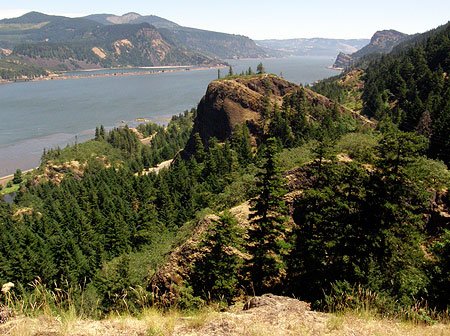
The main focus of the proposed trail network is Viento Bluff, the most prominent of the rocky outcrops that rise above Viento State Park, and a familiar landmark to travelers passing through the Gorge.
While Viento Bluff rises as sheer, 300-foot vertical wall on its north face, the steeply tilted basalt flows that form the bluff have a relatively gentle, meadow-covered south slope. The proposed summit trail would circle the bluff to reach this southern approach.

Historic CCC path along Viento Creek
The trail would begin at the existing day use parking area at the Upper Viento Campground, initially traveling on an existing footpath that follows Viento Creek into its shady, forested canyon. Here, the project would consist of a new footbridge connecting the existing trailhead to the old footpath, and improving the existing tread to basic trail standards.

Historic CCC path
The existing footpath appears to be one of the many vestiges of the Civilian Conservation Corps (CCC) in the Viento area. The CCC was created by Franklin D. Roosevelt as part of his Great Depression-era “New Deal” to put young men to work making infrastructure improvements to public lands across the country.
Several stone retaining walls in the area, the original (upper) Viento campground and a collapsed campground water house still remain from the CCC period. The surviving footpath originally led to the water house, but now terminates at its moss-covered ruins, along a pretty section of Viento Creek.

Remains of the old CCC water house along Viento Creek
From near the end of the existing footpath, the proposed route would turn east, climbing the slope to Viento Bluff in an easy traverse along a heavily used game trail. The deer and elk have done a find job in this section, with a grade that works well as a hiking trail!

Game trail leading from Viento Creek to the bluff
Soon, this game trail reaches a forested saddle behind Viento Bluff, and enters one of the most lush, abundant stands of poison oak anywhere in the Gorge — one of the few obstacles to realizing the Viento Bluffs trail.
While it’s an ominous sight for anyone sensitive to poison oak, routing a trail to the bluff through this section would be less difficult than appearances might suggest. The open, meadow-covered south slope of the bluff is only about 20 yards beyond the poison oak section, so the exposure would be no more than many trails in the Gorge that pass through poison oak patches. But it would need to be built carefully, and maintained accordingly.

Poison Oak heaven in the saddle south of Viento Bluff!
From the saddle, the route reaches the stuff of a dirt service road approaching from the east (more about that in a moment), and from this point, the proposed summit trail would begin an exceptionally scenic ascent of Viento Bluff’s south slope, traversing a steep meadow in switchbacks through scattered White Oak and Ponderosa Pine.

The south slope of Viento Bluff as viewed from the East Bluff
The summit of Viento Bluff is exposed on three sides, with vertical drops into the forest below. If this were a remote wilderness viewpoint, simply terminating the viewpoint trail at the top would be safe enough. But because it’s a state park with families and less-experienced hikers, some sort of cable or wood railing would probably be needed here. The wood railings at the Bridal Veil State Park overlook might be a good model for this site, and easily constructed here.

Gorge panorama from Viento Bluff
The view from the summit of Viento Bluff is impressive, especially given the relatively moderate climb required. The rocky slopes of Dog Mountain dominate the view across the Columbia River, and the sweeping panorama extends as far west as Table Mountain and east to Mitchell Point and the town of White Salmon, beyond.
The summit is quite spacious, providing room for visitors to sit and spend some time taking in the scene or having a trailside picnic. It is also far enough above the busy river corridor to be largely beyond the noise of traffic, while still allowing for interesting views of trucks, trains and barges passing by in the busy transportation corridor provided by the Columbia River Gorge.
East Bluff Trail
The East Bluff as seen from Viento Bluff
The second trail in this proposal would lead from the Upper Viento Campground and trailhead to the East Bluff, an impressive basalt outcrop that is nearly as imposing as Viento Bluff. The East Bluff rises directly above I-84, yet is oddly less visible from the freeway, and therefore less familiar to travelers.
The route to the East Bluff would begin along the proposed extension of the HCRH State Trail, east of the Upper Viento Campground. From a point along the State Trail route, about one quarter mile beyond the campground, a primitive service heads south, climbing the steep ravine between the East Bluff and Viento Bluff. This spur road soon reaches in the power line corridor that crosses the saddle to south of the two bluffs.

Mitchell Point and White Salmon in the distance from the East Bluff
From the saddle, one fork of the service road heads to the right, to Viento Bluff, as mentioned previously in this article. Along with the proposed new trail from Viento Creek, this route would create a loop hike to Viento Bluff, and a connection to the East Bluff (see map).
The left fork of the service road heads toward the East Bluff. This proposal calls for a new trail here, leaving the service road and traversing the open south slopes of the East Bluff in switchbacks.

The view west toward Dog Mountain and Stevenson from the East Bluff
The views from the East Bluff are expansive, encompassing the same stretch of the Gorge as the view from Viento Bluff, but including a unique perspective of Viento Bluff, itself.
The true summit of the East Bluff has a brass 1939 U.S. Geological Survey marker stamped “Viento”. The survey marker dates to the year when Bonneville Dam had just been completed, along with the old power line corridor behind the bluffs that took power from the new dam to Hood River and points east — likely the reason for a survey marker in this spot.

USGS marker on the summit of the East Bluff
The summit of the East Bluff is quite broad, and even somewhat brushy in spots. But several dramatic viewpoints ring the edges — much like Angels Rest in the western Gorge, but with a lot less effort. Like Viento Bluff, the cliffs are extremely exposed, and would require some sort of cable or wood fencing, given the location in a state park and relatively easy access.
The loop connection to the proposed Viento Bluff trail (from Viento Creek) would allow for both summits to be included on a longer hike, or simply a hike around Viento Bluff for those who don’t want to climb the actual summit.
West Bluff Loop Trail

West Bluff from the Viento interchange
The third piece of the Viento proposal is a short loop trail to the west bluff, a basalt wall rising 250 feet above the Viento interchange and Upper Viento Campground trailhead.
The purpose of the West Bluff trail is to provide a more approachable destination for less ambitious or able-bodied hikers and families with small children. While not as imposing as Viento Bluff and the East Bluff, the West Bluff still delivers impressive views of the Columbia Gorge and an interesting, almost aerial view into the Viento Campground and interchange area, directly below.

This service road would form the east leg of the West Bluff trail loop
The east leg of the loop would follow an existing dirt service road south from the existing trailhead, then fork uphill along a second service road that crosses within a few hundred yards of the West Bluff crest. A spur trail would climb the last stretch to the cliff-top viewpoints. Like the other summits, some sort of fence or railing would be in order here, as the cliffs drop over 200 feet to the trailhead below.
The west leg of the loop would be a new trail climbing a ravine directly below the West Bluff, connecting to the new summit spur. The complete West Bluff loop would cover less than a mile, and gain less than 300 feet elevation, yet give hikers a real sense of achievement. The West Bluff loop would also be the closest of the proposed trails to the main Viento Campground, so well situated to serve campers interested in a modest hike.
An interesting option for the West Bluff trail would be a barrier-free route. While this would be a much more substantial undertaking, it would be one of the few viewpoint trails in the Columbia Gorge available for visitors with limited mobility.
What would it take?
Much of this proposal builds on the repurposing of existing service roads to become wide trails — at least most of the time. The idea is to allow utility workers to access these roads when needed, but functioning as wide trails as their primary purpose. The service roads are owned and maintained by the Bonneville Power Administration (BPA), and see little use by the agency, so a shared purpose might be a way for the BPA to partner with Oregon State Parks to enhance and maintain these routes.

Historic retaining wall at Viento from the CCC era
There are also several new hiking trail segments in this proposal. All would be straightforward to build, with few topographic or environmental obstacles. Because they are located in a highly accessible area (access from I-84), these new trails could be excellent candidates for construction by volunteer groups like Trailkeepers of Oregon.

Upper Viento Campground restroom is within a few yards of the trailhead

The HCRH State Trail already has a major trailhead at Viento
One of the advantages of expanding hiking opportunities in the Viento area is the potential to take advantage of the existing recreation infrastructure: two campgrounds, a day use area, a large supply of trailhead parking, restrooms within a few yards of the trailhead, access to the HCRH State Trail and direct freeway access to I-84. Adding new trails to the area would simply make better use of these existing amenities in addition to enhancing the camping experience at Viento State Park.
What can you do..?
If you like this proposal, there is a unique opportunity to weigh in right now and make your voice heard: share your comments with Oregon Parks & Recreation Division (OPRD), the state agency that operates Viento State Park, and the sole agency responsible for trail planning in the park.

Seldom-seen rubber boa spotted along Viento Creek
Over the next year the state is conducting a long-range planning effort to scope future recreation needs in the Gorge. [url]You can weigh in with your thoughts over here.[/url] So far, the State Parks have had fairly light participation in their public outreach, so it’s important to make your views known!
Please consider including links to the Veinto Bluffs, Bridal Veil Canyon and Angels Rest Loop proposals in this blog when you comment — here are the quick links to paste into your message:
https://wyeastblog.org/2012/01/15/proposal-bridal-veil-canyon-trail/
https://wyeastblog.org/2013/08/31/angels-rest-loop-one-way-trip-to-heaven/
https://wyeastblog.org/2013/09/22/proposal-viento-bluff-trails/
And as I’ve pitched in previous articles, please consider supporting Trailkeepers of Oregon, a non-profit, grass-roots organization that offers meet-up trail stewardship projects in the Gorge and around the region (full disclosure: the author is a founding and current board member of TKO and number one fan of the organization!)

I’ve liked your trail suggestions, but have any of them ever been acted upon? Seems like we lose more trails each year than we make.
LikeLike
Thanks for stopping by, Gordon — and yes, that’s true, but changing that mindset with our federal land agencies (in particular) is half the battle. My goal is to raise expectations among hikers and turn the trend around by simply demanding better.
I do expect to see some of these proposals become reality, but the first step is simply putting an alternate vision out there to counter the downward trend that we’ve seen in recent years. My involvement with TKO is another avenue for reversing the trend, too… it’s all about being heard!
The good news is that the Forest Service picture for the Gorge is better than at Mount Hood, with the agency still funding a small trail crew (there have been no USFS trail crews for Mount Hood for at least two year – at all!) So, we’re losing less ground on federal lands in the Gorge.
But the better news is that Oregon State Parks is actively looking to revisit their recreation plans, so this is a perfect time to weigh in — I’ve posted links to the proposals from this blog at the end of this article, and I’d encourage anyone concerned about trails in the Gorge to go to the State Parks website and make your views known!
Tom
LikeLike
Tom – Are you sharing these ideas with Jaime English at State Parks? I hiked up the east butte and discovered a rock by the Powerline pole that seem like it came from the bottom of the lake…it had crystals and little seashells stuck in it. Those Missoula Floods were incredible..
LikeLike
Thanks, Kristen – nope, not yet, but apparently I need to!
Tom 🙂
LikeLike
Pingback: Proposal: Mitchell Point Loop Trails | WyEast Blog
Pingback: Gorge Plan hits crucial stretch! | WyEast Blog