
Today’s wayside is located at the east end of the Latourell Bridge, where the Falls Chalet roadhouse once stood in 1914 (shown here)
Over the past few years, Oregon Parks & Recreation has set the high bar for recreation improvements on the state lands it manages in the Columbia River Gorge Scenic Area. The latest project is a handsome, thoughtful makeover of the Latourell Falls wayside, located along the Historic Columbia River Highway (HCRH) in Talbot State Park.
The Latourell wayside serves thousands of Gorge tourists each year, and also functions as the trailhead for the very popular Latourell Falls loop trail. The site has a long history, and was once home to a pair of roadhouses during the heyday of Samuel Lancaster’s world-class highway in the early 1900s.

The Falls Villa roadhouse was located across the road from today’s wayside through the 1930s, now marked only by a stand of mature bigleaf maple
Modest improvements to the wayside over the years included interpretive historic signs added in the 1990s that tracked the colorful human history of the area, but for the most part, the site was dated and dingy. The restoration work completed last summer is thus a major upgrade that deserves a review here. The work was completed with a special grant secured by the Oregon State Parks department
Makeover Review
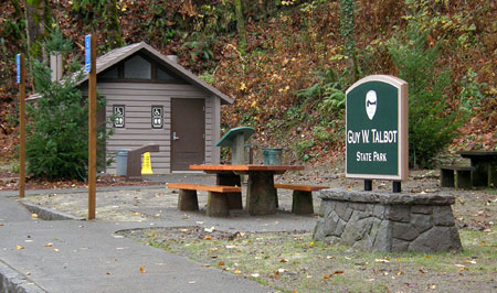
Front and center in the rebuilt wayside is the official state park sign, constructed in the standardized style used for both national forest and state park units throughout the Columbia Gorge National Scenic Area (CGNSA). The sign is mounted on a newly constructed basalt base, also designed in the uniform CGNSA style.

Welcome (again) to Guy W. Talbot State Park!
One missed opportunity in repurposing the existing entry sign was the chance to tell the story of Guy Talbot (picture below, in the early 1930s), one of the business titans of early Portland. Talbot donated the land containing Latourell Falls and the gorgeous canyon above the falls, so deserves more than passing mention in the human story of the area (along with other benefactors who donated the lands we now know as the state parks gems dotting the Historic Columbia River Highway).

Guy W. Talbot as he appeared in 1933 on the front page of the Oregonian, announcing his retirement
Two enamel interpretive panels installed at the wayside in the 1990s were salvaged and reinstalled in the new layout. One focuses on the history of the historic highway (the photos of the roadhouses, above, are from this display) and is now mounted in outside a new restroom (below). It’s a well-trafficked location, albeit sorely lacking in aesthetic appeal! The second interpretive sign is located at the main falls overlook, and briefly describes the history of private land donations for parks in the Gorge.
The new restroom is located at the east end of the wayside, tucked away from most of the picnic tables and a good distance from the new falls overlook plaza. While modern budgets probably require the low-maintenance advantage of pit toilets, the more civilized flush toilets that were removed were an aesthetic notch above the smelly nature of a chemical toilet.
The new restroom is (unfortunately) the standard pit-toilet style found elsewhere along the old highway
Considering the volume of visitors to this park, plumbed toilets may be essential — we shall find out soon enough! Fortunately, flush toilets at historic highway waysides still survive at Bridal Veil, Multnomah Falls, Ainsworth State Park, Eagle Creek, Bridge of the Gods and Starvation Creek.
But a major improvement that comes with the new restroom is the location on the south side of the old highway, adjacent to the parking area — the old restroom required crossing the highway. The new toilets are also ADA accessible, along with the drinking fountain located outside the restroom and two of the nearby picnic tables.

Accessible drinking fountain located outside the restroom
An unexpected benefit from the relocated restrooms: it turns out the old restrooms blocked a very nice view of the Latourell Bridge (below), framed by mossy bigleaf maple trees. The old restroom site is marked only by a flat spot below the highway. The low-headroom trail under the bridge that once accessed the restroom has also been decommissioned.

The view that used to be behind the restroom..!
Other details of the new wayside design include basalt curbs that edge the repaved parking area (below), and bicycle racks for cyclists touring the old highway to safely stop and admire the upper viewpoint, fill water bottles, picnic or use the restrooms.

Stone curbs show the attention to details paid by the designers
One thoughtful aspect of the new bicycle racks is the central location: too often, bicycle parking is relegated to an unused corner. This makes for much less secure parking than a more prominent location, where the public eye is more likely to deter sketchy behavior.

Centrally located bike racks front the main parking area
The west end of the wayside is the primary focus for visitors, with a handsome plaza and several new visitor amenities. A concrete-capped stone wall in the Gorge style wraps around the plaza, with notched insets for visitor information and interpretive sign installations.
An attractive, new visitor information sign (below) is an excellent addition to the wayside. While it contains the standard park information found at most state parks, an excellent trail map describing the Latourell Creek loop hike is also featured. Even better, the map isn’t of the cartoonish variety often found at tourist waysides. Instead, it shows accurate trail information and even includes elevation contours!

The handsome new visitor information sign at the Latourell wayside
The visitor map does a good job of showing the hiking options and trail highlights, as well as helpful tips on the multiple (and somewhat confusing) trailheads that provide access to the loop. A nice cartographic touch is attention to showing private lands that abut the park (though hopefully some future version of this map will show those lands in public ownership, through the Columbia Gorge Scenic Area acquisition program!)

The excellent, new Latourell Falls Loop map
One minor map glitch exists: the labeling of “Upper Falls” and “Lower Falls” may work for most people, but using the proper place name for Latourell Falls (instead of “Lower Falls”) would be more accurate and informative to those visiting the park for the first time (the upper falls is known unofficially as “Upper Latourell Falls”, so not an issue). There’s rarely a good reason to deviate from official geographic names on maps, after all.
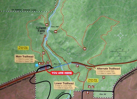
A closer look at the excellent detail on the new park map
Hopefully, the State Parks folks will also provide a downloadable, online copy of this map at some point — one that non-profits like Portland Hikers could also offer on their user-created Field Guide, for example.
Another nice touch on the visitor information sign is the high-profile shout-out to the Columbia Group of the Sierra Club, the volunteer trail stewards for the Talbot State Park (thanks, Sierra Club!). Not only are the signs a welcome recognition of trail volunteers, but also a subtle tool for raising public awareness to the unfortunate reality that volunteers have become an essential partner to public agencies in keeping our trail system open.

Kudos to the Sierra Club volunteers!
The photo below shows the new visitor information sign from the perspective of the new plaza, with the restrooms visible in the far distance.

The view toward the visitor signboard and steps leading to the upper falls viewpoint from the new plaza (interpretive sign in foreground)
This view also shows the second notched inset in the curving basalt wall that defines the plaza overlook, where the second refurbished interpretive sign has been installed. This sign briefly describes how Latourell Falls and other nearby parks came into public ownership in the early 1900s, and is the only mention of Guy Talbot in the wayside beyond the entry signs — an oversight that is a missed opportunity in the redesign (more about that coming in Part 2 of this article).

Latourell Falls from the new plaza overlook (with the interpretive sign on the left)
The new plaza corrects many serious problems with the old design, starting with the need for a more spacious falls overlook that respects the historic design of the Samuel Lancaster’s Columbia River Highway. The new plaza meets this test with flying colors, including a subtle, but helpful detail of steps replacing ramps at both the upper and lower loop trailheads.

Another view from the plaza showing the interpretive sign (in the distance) and steps leading to the lower end of the Latourell Falls loop
Because the opening segments of the loop in both directions are paved, there has always been a temptation for people with strollers (or worse, wheelchairs) to assume the trail is safe for wheeled vehicles — it is not! Thus, the new steps will help visitors with strollers and mobility devices to avoid the dangerous mistake of venturing onto the loop trail.
The plaza forms a semi-circle in order to incorporate a second view of the spectacular Latourell Bridge in addition to the falls view. This is an unexpected discovery for visitors arriving over the bridge, unaware of its soaring height and graceful arches.

Wayside details: Samuel Lancaster would approve!
On this detail, the designers hit a home run, with a series of arches built into the basalt walls that beautifully echo the bridge design, and seamlessly tie the wayside into the highway, itself, as a natural extension of Samuel Lancaster’s masterpiece. Each arch also includes a painted steel grate – a nice detail that will keep kids and pets on the plaza-side of the stone walls.
A newly installed, arch-back bench at the head of the lower loop trailhead gives a similar nod to the historic bridge, while also helping terminate the decommissioned path that once accessed the old restroom, via a narrow, sketchy path that ducked beneath the bridge (the wood post rails in the photo below block the route of the old path).

This stately bench salutes the old highway bridge, a nice touch!
In the center of the new plaza, the designers have incorporated a long planter-bench (below) that will be a welcome respite for visitors to sit and enjoy the view. However, the design of the bench planter is problematic: The narrow planting compartment is not irrigated, and thus presents a tough landscape dilemma. The designers planted mahonia nervosa, or longleaf Oregon grape that should be drought-tolerant enough to survive, and compact enough to fit the narrow space. But it will also a prickly companion to share the bench with! Perhaps this was intentional (as a means to keep the plants from being crushed)?
The other dilemma with planters of this type is the frustrating reality that it will become an oversized ashtray over time. In the end, it might have made more sense to simply design a wide bench with a solid top for the plaza (which is certainly an option for retrofitting this bench, as needed).

A large planter bench anchors the new plaza
The revamped wayside also includes improvements to the popular upper viewpoint, located just east of the visitor information sign. The upper viewpoint path is also the trailhead for the upper portion of the Latourell Falls loop.
The stairway to the upper viewpoint path (below) also forms the terminus of the stone wall that defines around the plaza, and is nicely designed to simply lead wandering visitors to the overlook. Like the steps at the opposite end of the plaza that lead to the lower trail, these steps may help deter wheelchairs and strollers from the steep, unsafe climb to the upper viewpoint.

New steps leading to the upper falls viewpoint and loop trail
Unfortunately, the upper viewpoint path is one of the disappointments in the Latourell makeover. The short, existing section of paved trail to the viewpoint is steep and slick even for able-bodied hikers. Worse, it becomes a terrifying skating rink in winter ice conditions — which happens to be a time when the Gorge is often crowded with visitors admiring the spectacle of waterfalls transformed into ice cathedrals.
While the new handrails help, a home-run design here would have been a series of steps and landings all the way to the viewpoint — picture a scaled down version of the stairs approaching the lower Multnomah Falls viewpoint as an example. Instead, the improved steps at the base of the path taper onto the old path in a fairly awkward transition, an understandable budget constraint, no doubt, but a missed opportunity, nonetheless.

Unfortunately, this ugly, occasionally dangerous path remains a sore thumb…
After walking the brief section of old paving, visitors suddenly reach a completely reconstructed upper falls viewpoint (below) with nice attention paid to views. The basalt surround at the viewing platform has a subtle cutout where a steel fence allows the falls to be more fully viewed when approaching the overlook. This design replaces an old stone wall that once blocked the view from the trail, so is an especially thoughtful detail.

The revamped upper viewpoint platform is a major upgrade, albeit marred by the ugly approach on a steep, outmoded old trail
The awkward transition from the ugly remnant section of the old pathway to the new platform detracts from the otherwise beautiful scene, but is also something that can be remedied with future enhancement to the viewpoint.

The disappearing Latourell Falls view: a thorny problem?
Some unfinished business exists at the upper viewpoint, and it might fit into the State Parks operations budget: any photographer will attest to some much-needed “view management” here. Over the past decade or two, the brushy slope below the viewpoint (below) has swallowed up the bottom third of the falls. It’s something that a bit of pruning would greatly enhance. As recently as the 1990s the splash pool at the base of Latourell Falls was clearly visible from the viewpoint.
A Legacy Achievement
Though there will always more work to do in bringing the Gorge trails and byways closer to the national park standard, the Latourell Falls makeover is a terrific step in that direction. The project achieves a level of quality and permanence that few improvements manage.

Latourell Falls from the new wayside plaza
The new space created and constructed by the State Parks team will easily last for decades, joining the rest of the historic Columbia River Highway as a stunning blend of nature and architecture that continue to thrill visitors from around the world. It’s truly a legacy project, and all who were involved in the design and construction deserve our kudos – thank you!
______________________________
(Next up in the Part 2 of this article: a look at the Latourell Loop trail and possible improvements that would bring this popular trail to its full potential)
______________________________

We are volunteers at The Vista House who have learned of your blog through a friend. Your information on the Latourell Falls renovation is dynamically written and so appreciated. What an education you gave us! Thanks so much.
LikeLike
Thank you, Claudia! Glad you found the blog, and kudos to you for dedicating your time to the Vista House — volunteers like you are my heroes! 🙂
LikeLike
Pingback: Mount Hood Loop Interpretive Signs | WyEast Blog